Report on the ascent of Peak "50 лет ВЛКСМ" (5801 m) via the eastern edge (first ascent) by the sports group of the Tomsk Alpinade
Khrebet Kommunarov
June–August 1968
Group leader (E.F. Kharchenko) Team coach (G.G. Andreev) Tomsk
1968
1. Geographical location of Peak "50 лет ВЛКСМ" (5801 m)
Peak "50 лет ВЛКСМ" is located in the main ridge of the Khrebet Kommunarov, it is the highest point of the ridge. The western edge of the summit faces the Baygashka River, and the eastern ones — the Karadzhilga River.
The snow line in this area lies at an altitude of about 5000 m. The ascent was made from the base camp located in the Baygashka River valley at an altitude of 4900 m during the expedition.
2. Climbing conditions
a) Relief
The ascent was made along the eastern ridge, which mainly consists of rocks, partly destroyed, and partly made of solid granite, with ice and snow with rocks in the upper part. The rocks up to the pre-summit ascent are cleared of snow. The ascent path to the summit from the base camp has a difference of 1600 m and an average steepness close to 50°.
b) Weather
From July 13 to August 13, during the period of the expedition and ascent, the weather was good: sunny, warm, light breeze, on the last day — rare cloudiness.
3. Organization and tactical ascent plans
3 days were planned for the route. The group was well acclimatized. The route was viewed from the base camp. The auxiliary group, remaining in the base camp, kept direct observation of the signals throughout the ascent.
Communication was carried out using rockets. The group on the route had a tent and a three-day supply of food and gasoline. Equipment was used according to tested samples, no new equipment was tested.
4. Group composition:
- Kharchenko E.F. — leader, 1st sports category
- Kholmansky G.N. — participant, Candidate for Master of Sports
- Vernov A.A. — participant, 2nd sports category
- Melkov V.I. — participant, 2nd sports category
On August 7 at 16:00, the group, after a one-day rest, left the base camp and, crossing the Baygashka River, began the ascent to the unnamed glacier. The path went along the bank of the stream flowing from the glacier. Before the tongue of the glacier, we crossed the stream to the left and walked along the boundary of the coastal moraine and the glacier. After 3 hours of walking from the base camp, we stop for the night opposite the talus couloir, which opens onto the western shoulder of Peak "50 лет ВЛКСМ".
The next day at 6:00 am, we left the overnight stay and began to climb the talus couloir. The talus is very fine, it flows underfoot, and the ascent is very difficult. After 1 hour, we approach the "ram's foreheads". We overcome the "ram's foreheads" with insurance for ledges in 30 minutes. Further, the path lies again on the talus and after 1 hour we reach the isthmus. From the isthmus begins, directly, the route along the eastern ridge of Peak 5801 m.
Section R0–R1. Photo №3
The beginning of the section — rocks with a steepness of 30–50°. Four ropes passed by free climbing with alternate belay, the route is chosen between the gendarmes, constantly encountered on the way. After 1 hour, we approach a chimney (30 m) with a steepness of 60–70°. We pass the chimney with piton belay. After the chimney, we reach a rocky edge with a steepness of 40–45°, which we pass by free climbing with alternate belay for ledges.
Section R1–R2. Photo №4
It is a wall with a steepness of about 80°, height about 60 m. The section is passed on the left side (along the route) with piton belay and installation of fixed ropes. On the wall, there are several shelves filled with snow.
Section R2–R3
After the wall, we reach the ridge with destroyed rocks. On the way, there are "ram's foreheads", we pass between them or bypass, all the time going either to the right or to the left. The gendarme is bypassed on the right along the shelves. Belay is piton and for ledges.
Section R3–R4. Photo №5
It is a chimney at the base with a section of flow ice. One rope passes along the ice with piton belay (2 ice screws) and cutting steps. Further along the chimney, there is climbing in "expansion" with piton belay and organization of fixed ropes.
Section R4–R5
A sharp ridge with destroyed rocks with a steepness of 40° to 60° is passed simultaneously with belay for ledges. The rocks are destroyed, in some places quite difficult.
Section R5–R6. Photo №6
The gendarme is bypassed along the couloir on the right with an exit to the wall. The wall is an inner corner 130–150°, with a steepness of up to 80°. It is passed first along a sharp destroyed ridge, then to the left 20 m and up along the corner to the ridge itself. The talus ridge with rocks dividing the talus. There are good places for setting up a tent and organizing an overnight stay. In 2000, we set up a tent and stop for the night.
Section R6–R7. Photo №7
On the morning of August 9 at 7:00, we go on the route. The loose ridge turns into steep rocky "foreheads", which are passed with simultaneous and alternate belay. The route approaches a chimney with a cork, which is passed with piton belay. After the chimney — an exit to the ridge, from which it immediately turns into a steep snowy ascent (avalanche-prone). The snowy ascent turns into a sheer rock, which is passed head-on with piton belay.
Section R7–R8
After a sheer rock, we reach again a sharp ridge with dips and ascents of 10–15 m. We pass simultaneously and with alternate belay for ledges, overcoming ledges.
Section R8–R9. Photo №8
The ridge turns again into a steep snowy ascent, ending in a sheer rock. It is impossible to bypass on the right. On the left — an avalanche-prone snowy slope. Under the dense snow layer, the snow is loose and goes underfoot. We decide to pass head-on. A difficult transition from a snowy ridge to a rock. We hammer 4 pitons in a 10 m section. The rock has very small icy footholds.
Section R9–R10
After passing the rock, we reach the pre-summit ridge. The pre-summit ridge is destroyed rocks, partly covered with snow. Before the summit, we pass a snowy plateau, on which the summit with cornices is located. At 14:22, we reach the summit.
Descent
At 15:22, we begin the descent. The descent goes along the eastern ridge, which is destroyed rocks. Then we go to the right onto a snowy slope, which is covered with small "kalgasporas". Snowy "kalgasporas" go onto a slope with small talus. The descent is quite easy. After 3 hours, we approach the glacier to the overnight stay on the talus couloir. After a short rest, we return to the base camp.
By right of first ascenders:
- Peak 5801 m is named in honor of the 50th anniversary of the Komsomol — Peak "50 лет ВЛКСМ".
- On the summit, we left a memorial plaque with the inscription: "Alpinists of Tomsk — to the 50th anniversary of the Komsomol 1918–1968. Regional Committee of the Komsomol".
- The route along the eastern edge to Peak 5801 m, the group of first ascenders estimates at 4B category of difficulty.
Team captain (E.F. Kharchenko) Team coach (G.G. Andreev)
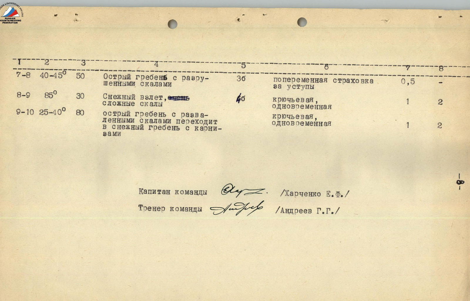
| Passed sections | Average steepness of the section | Height difference | Character of relief | Category of difficulty | Method of belay | Time taken | Pitons |
|---|---|---|---|---|---|---|---|
| Approaches to the route | 20–30° | 650 м | moraines, talus (small and large), "ram's foreheads" | 2А | without belay and belay for ledges on "ram's foreheads" | 6 h 30 min | — |
| R0–R1 | 30–70° | 250 м | loose rocks, 30 m chimney, rocky edge | 4А | belay for ledges, pitons, fixed ropes | 2 h | 4 |
| R1–R2 | 80° | 60 м | rocky wall with snow on shelves | 5А | piton belay | 2 h | 5 |
| R2–R3 | 45–85° | 150 м | destroyed rocks, rockfall hazard, steep ascents, gendarme is bypassed on the right along the shelves | 4А | piton belay and for ledges | 1 h 30 min | 6 |
| R3–R4 | 50–80° | 80 м | section of flow ice, chimney | pitons (ice and rock), cutting steps, fixed ropes | 1 h 30 min | 3 | |
| R4–R5 | 45–60° | 150 м | sharp ridge, rocks are heavily destroyed | 4А | belay for ledges, alternate | 2 h | — |
| R5–R6 | 75° | 50 м | gendarme is bypassed along the couloir, walls with an inner corner | 5А | piton belay, fixed ropes | overnight stay | 4 |
| R6–R7 | 30–45° | 50 м | talus ridge, divided by rocks of medium difficulty | 3А | simultaneous belay for ledges | 30 min | — |
| R6–R7 | 60–85° | chimney with a cork, snowy avalanche-prone ascent turns into steep rocks with an exit to the ridge | steps, piton belay | 2 h 30 min | 7 | ||
| R7–R8 | 40–45° | 50 м | sharp ridge with destroyed rocks | 3Б | alternate belay for ledges | 30 min | — |
| R8–R9 | 85° | 30 м | snowy ascent, very complex rocks | 4Б | piton belay, simultaneous | 1 h | 2 |
| R9–R10 | 25–40° | 80 м | sharp ridge with destroyed rocks turns into a snowy ridge with cornices | piton belay, simultaneous | 1 h | 2 |
Peak 5801 m
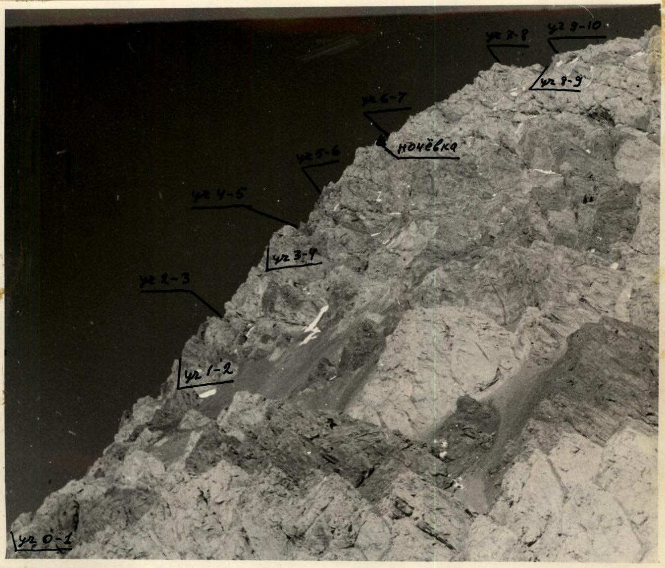
View from the unnamed glacier (from the north). The route passed along the ridge, so only the sections are marked here.
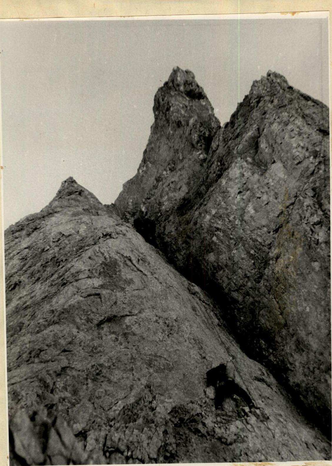
Photo №2. Section R0–R1. Chimney.