Report
On the ascent of the MAI Climbing Club team
to Lenin Peak (7134 m) via the Southwest Ridge of the West Crest (first ascent) from August 31 to September 2, 2012
Captain: A. Lebedev, Coach: A. Lebedev
Ascent to Lenin Peak (7134 m) via the Southwest Ridge of the West Crest (first ascent)
Passport
- Region: Trans-Alay Range (Pamir)
Valley: Malaya Saukdara, category according to the 2011 classifier — 4.4
- Name of the peak: Lenin Peak (7134 m)
Name of the route: via the Southwest Ridge of the West Crest
- Proposed category: 5A (op)
- Character of the route: snow-ice
- Height difference of the route: 1134 m (according to GPS)
Route length: 3130 m. Average steepness:
- total route — 25°
- main part (6090-6740) — 30°
- Number of pitons left on the route: 0
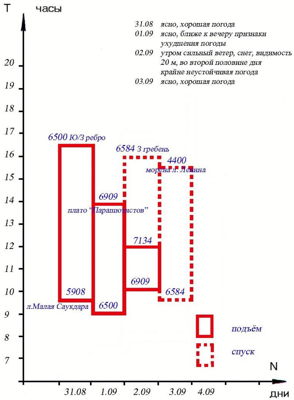
- Total climbing hours: 14 h 30 min, 2.5 days
- Leader: Lebedev A.A. (Moscow, Master of Sports of Russia in Tourism, 1st sports category in Alpinism)
Team members:
- Babich M.V. (St. Petersburg, 1st sports category in Tourism)
- Zhdanov I.N. (Moscow Oblast, 1st sports category in Tourism)
- Lavrinenko V.V. (Moscow, Master of Sports in Alpinism)
- Maximovich Yu.A. (Moscow, 1st sports category in Tourism)
- Coach: Lebedev A.A.
- Start of the route: 9:30 August 31, 2012
Summit: 11:30 September 2, 2012
Return to the Lenin Peak camp (4400 m): 18:30 September 3, 2012
Technical complexity and labor intensity of the route
To briefly recall, after completing a 19-day (from July 30 to August 17) preliminary acclimatization cycle of the entire event, namely:
- making two first ascents to the peaks of Peak 4765 and Panorama Peak (5027),
- passing a variant on Obruchev Peak (5459),
- making an ascent to Spartak Peak (6134),
The team, after an overnight stay at 6500 m on the eastern shoulder of Lenin Peak, descended to Achik-Tash via the Lipkin Rocks. One day of rest (August 18) and the start of the ascent to Lenin Peak. In 15 days of complete autonomy, with a starting weight of 35 kg in their backpacks, passing the Minjar Pass, the team approached the southwestern slopes of the Trans-Alay Range.
Then, overcoming numerous difficulties of the Kuzgun Glacier and the Sauksay River rapids, passing the Przhimny Pass, the team approached the southern slopes of Razdelnaya Peak (6120) via the Dzerzhinsky Glacier.
The route further included:
- Lenin Pass (6400)
- Descent to the upper plateau of the Malaya Saukdara Glacier (5900 m)
On the upper plateau of the Malaya Saukdara Glacier, a new "thread" of the route to Lenin Peak was planned, namely via the Southwest Ridge of the West Crest.
The aforementioned approach is well-illustrated in the previous chapters, described in detail, and richly photo-illustrated.
As for the ridge itself, it is also described in the corresponding section.
Once again, it is worth noting that this is one of the last unclimbed routes to the peak. The ridge is very logical, beautiful, and safe. The height difference, up to the exit to the Parachutists' Plateau, is more than 1 km, with an average steepness of 25–30 degrees.
The condition of the snow and ice cover is extremely diverse:
- soft deep snow;
- hard firn.
Particular "inconveniences" were caused by the breaking crust of snow (even when moving in snowshoes) under the not-so-small weight of the athletes. There is no avalanche danger, although there are sufficiently wide ice crevasses.
From approximately 6300 m, the following start to appear:
- outcrops of the rocky ridge;
- small wall sections, iced over (on some of them, for the group's acceleration, perila were hung).
Practically the entire ridge was traversed by autonomous rope teams and in crampons. When necessary, snowshoes were worn. The ridge itself was traversed in a day and a half, with an overnight stay at 6500 m.
There are no serious technical difficulties on the route, but at the same time, the route is quite labor-intensive (based on the format of our autonomous ascent).
From the ridge, to the south, a stunning panorama of the entire Pamir opens up:
- Peak Russia;
- Peak Communism;
- Peak Korzhenevskaya;
- Peak Revolution;
- Peak Marx, etc.
To the left of the direction of movement, Peak Dzerzhinsky is constantly visible, and to the right — Peak Zhukov, which serve as своеобразные landmarks for gaining height. Below is the Malaya Saukdara Glacier. This is well visible in the photographs.
At a height of 6900 m (with the exit to the Parachutists' Plateau), the route coincides with the "classic" route. This is a sufficiently dissected and wide West Crest with rock outcrops. In bad weather, problems with orientation on the route may arise (especially on the descent from the summit).
In conclusion of this section, it is worth noting again the not-so-simple and lengthy approach to the start of the route (two options were mentioned above), which completely excludes the use of both motor vehicles and a caravan with porters (they will not pass through the Minjar Pass).
In the opinion of all team members, who have extensive experience in high-altitude ascents, the proposed category of difficulty fully corresponds to the 5A category.
Technical photography of the route.

Heightmarks break the route into sections: 6000, 6090, 6144, 6222, 6400, 6500, 6740. The 6500 mark is the overnight stay from August 31 to September 1.
General photo
of the summit.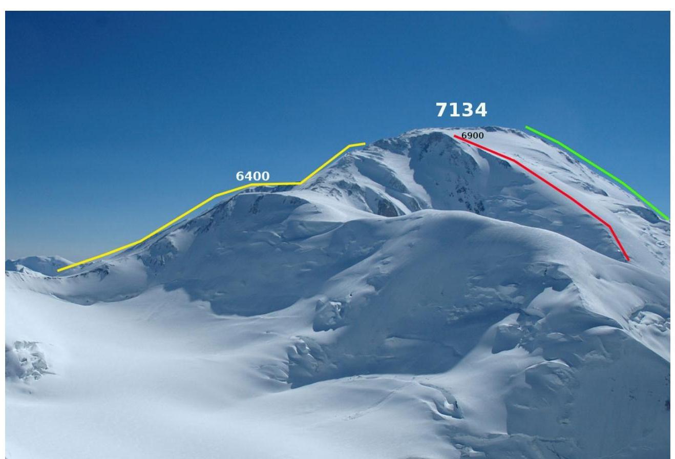 View
of Lenin Peak from Peak Dzerzhinsky (photo by D. Zelentsov, 2007). The following routes are marked:
View
of Lenin Peak from Peak Dzerzhinsky (photo by D. Zelentsov, 2007). The following routes are marked:
- Red line — route via the Southwest Ridge of the West Crest.
- Yellow line — route via the West Crest (V. Kovalev, 1954).
- Green line — route via the Southwest Crest (N. Yushin, 1967).
Ascent schedule