CS "DSO "Zalgiris""
ASCENT TO LENIN PEAK (7134 m) FROM THE SOUTH 5A cat. sl. IN HONOR OF THE 25th ANNIVERSARY OF SOVIET LITHUANIA
(report for the 1965 USSR Climbing Championship)
Vilnius, 1965
II. BRIEF GEOGRAPHICAL DESCRIPTION AND SPORTING CHARACTERISTICS OF THE LENIN PEAK REGION
Lenin Peak, with an elevation of 7134.3 m above sea level, is located in the middle part of the Trans-Alai Range and is its highest peak. The peak is connected to Peak Dzerzhinsky (6713 m) to the west and, via the Krylenko Pass (5820 m), to the ridge of Peak Edinstva (6673 m) to the east. To the south, in a spur of the Lenin Peak massif, lies the Moscow-Peking Peak (6852 m). The Lenin Glacier flows from the northern massifs of Lenin Peak. The southern slopes of the peak are drained by the glaciers:
- Big Sauk-Dara (to the east)
- Small Sauk-Dara (to the west)
The elevation difference between Lenin Peak and the middle part of the Sauk-Dara Glacier is about 3000 m. The slopes of the peak are covered with glaciers and thick layers of firn snow. In some places, the slope steepness reaches 55°. The slopes are cut by crevices up to 100 m or more in depth. Snow avalanches and ice collapses are frequent. Atmospheric pressure at the summit (7134 m) is 290 mm.
Lenin Peak is the third highest seven-thousander in the USSR and is quite popular among climbers due to its relatively easy access to the starting points of the ascent. Most ascents are made from the northern side, from the Lenin Glacier.
Ascents from the southern side:
- involve significantly longer approach routes with a crossing of the 5000 m Profsoyuzov Pass;
- require more preliminary work to transport food and equipment from the end of the Oktyabrsky Glacier tongue, where the base camp is set up, to the Sauk-Dara Glacier and further up to the Krylenko Pass.
At the same time, an ascent from the southern side provides an opportunity to explore an extensive mountain region that is relatively little researched and of significant mountaineering interest.
From a sporting perspective, the ascent to Lenin Peak requires the use of exclusively snow and, in some places, ice climbing techniques.
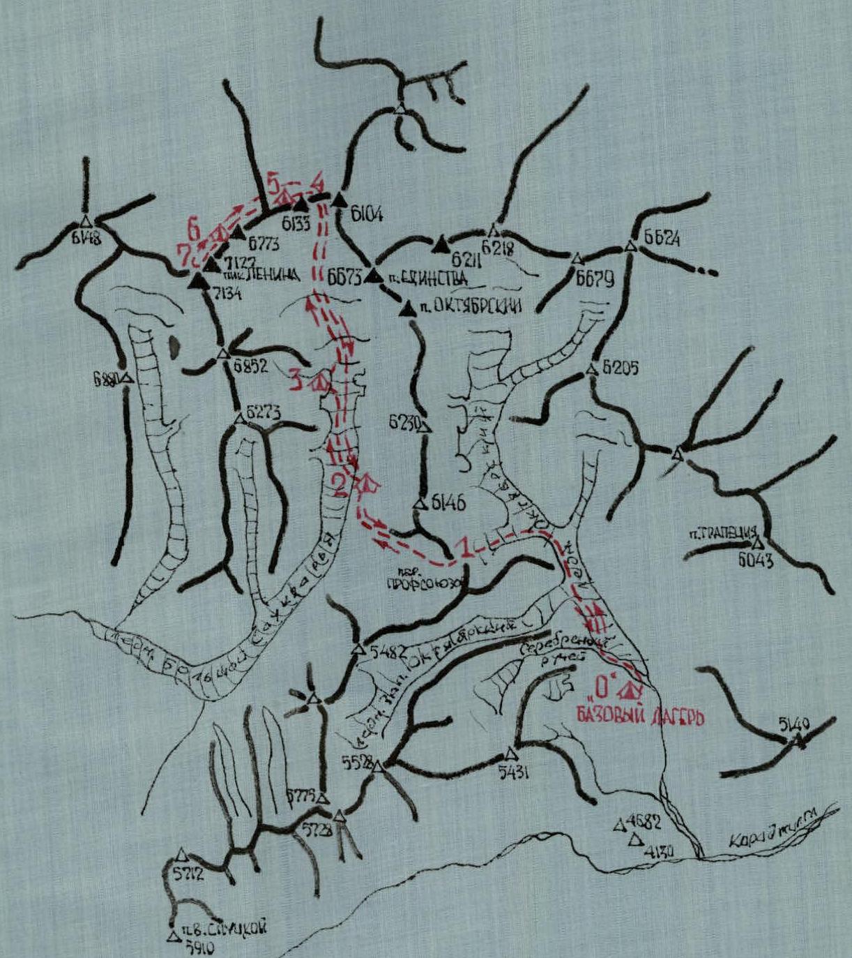
SCHEMATIC DIAGRAM OF THE ASCENT ROUTE TO LENIN PEAK FROM THE SOUTH
At the same time, the ascent requires high physical and mental preparedness and serves as a test of a climber's high-altitude capabilities.
III. ASCENT CONDITIONS
The final point accessible by transport is the tongue of the Oktyabrsky Glacier at an elevation of 4200 m, 50 km away from the Pamir Highway.
From a mountaineering perspective, the region south of the Lenin Peak massif began to be explored in 1955 (not counting the 1928 expedition, which worked mainly in the southwestern part of the Sauk-Dara Glacier). Despite the fact that in recent years, mountaineering expeditions have visited the Oktyabrsky Glacier region almost annually, and the nearby Baygashky River valley and the Sauk-Dara Glacier cirque, most peaks in the area have not been climbed.
The climate of the region is characterized by sharp contrasts and variability. On clear days, it is very hot, and the sun is followed by frost at night. In August, heavy snowfalls are possible at elevations from 4000 m and above. The region is characterized by constantly blowing strong winds (6–8 m/s) and gusty hurricane-force winds on the ridge of Lenin Peak.
In July-August 1965, the weather in the Oktyabrsky and Sauk-Dara Glaciers region was extremely unstable. Despite the characteristic dryness of the air for this region (15–30%), the number of days with precipitation exceeded the number of sunny days. For example, on the night of August 1-2, a snowstorm raged for 1.5 days, and up to 700 mm of fresh snow fell in some places at the Krylenko Pass. Strong fogs were frequently observed. At the same time, during 2–3 sunny days, the snow cover warmed up significantly up to an elevation of 5000 m, making movement on it practically impossible after 14:00.
The main danger encountered during the crossing of the Profsoyuzov Pass and in the upper cirque of the Sauk-Dara Glacier is the large number of hidden crevices covered by unreliable snow bridges.
The significant remoteness of the peak from the base camp (40 km in distance and 3 km in elevation) necessitates the transportation of a large amount of cargo.
Even with a well-chosen high-calorie diet, the weight of backpacks when starting the ascent is about 30 kg.
IV. RECONNAISSANCE AND SUPPLY RUNS
The first reconnaissance and acclimatization trip to the upper reaches of the Oktyabrsky Glacier was conducted on August 13, 1953, with the goal of:
- scouting the route to the Profsoyuzov Pass;
- selecting routes for training ascents.
On August 15, 1953, a trip was made to the Baygashky River valley to familiarize ourselves with the area.
On August 17, 1953, a supply run was made to the foot of the Profsoyuzov Pass.
On August 20, the first batch of supplies, along with an additional shipment, was transported to the Sauk-Dara Glacier basin.
On August 27, supplies were delivered, and a snow cave was built on the Krylenko Pass.
All team members participated in the reconnaissance and supply runs.
V. COMPOSITION OF THE CLIMBING TEAM
For participation in the championship, the USSR Climbing Federation approved 12 athletes and a coach. From the approved roster:
- one participant did not leave Vilnius;
- one fell ill in the base camp and was sent to Osh.
Thus, the group made the ascent in the following composition:
- ALKHUTOV Nikolai (coach), born 1930, Russian, senior engineer at p/ya 3731 in Moscow, has been involved in mountaineering since 1950, Master of Sports.
- ANTANAVICHUS Iozas, born 1940, Lithuanian, musicologist, senior laboratory assistant at the State Conservatory, has been involved in mountaineering since 1959, 1st category.
- BINKAUSKAS Boleslavas, born 1939, Lithuanian, leading engineer at the Institute of Physics and Mathematics, Lithuanian Academy of Sciences, has been involved in mountaineering since 1960, 1st category.
- VARANKA Antanas, born 1937, Lithuanian, mountaineering instructor, has been involved in mountaineering since 1958, 1st category.
- GUCHAS Augis, born 1940, Lithuanian, teacher at the Siauliai Music Technicum, has been involved in mountaineering since 1958, 2nd category.
- KUBILIS Augustas, born 1933, Lithuanian, engineer at p/ya 304 in Kaunas, has been involved in mountaineering since 1959, 1st category.
- MIGLINAS Stasys, born 1930, Lithuanian, head of the PPO at Construction Department No. 6 in Vilnius, has been involved in mountaineering since 1959, 1st category.
- MONSTVILAS Kazys (team leader), born 1934, Lithuanian, geological engineer at Promproekt, has been involved in mountaineering since 1959, 1st category.
- OKULICH-KAZARINAS Jaroslavas, born 1931, Lithuanian, engineer at p/ya 304 in Kaunas, has been involved in mountaineering since 1958, 1st category.
- SHADUIKIS Vilus, born 1940, Lithuanian, senior engineer at the Design and Construction Bureau for Mechanization and Automation, Lithuanian SSR, has been involved in mountaineering since 1960, 2nd category.
- SHTEIN Alexander, born 1928, Jewish, chief project engineer at ENIMS in Vilnius, has been involved in mountaineering since 1951, 2nd category.
VI. ORGANIZATIONAL AND TACTICAL PLAN FOR THE ASCENT
In the winter of 1964-1965, intensive preparations began for the ascent to Lenin Peak. The Climbing Federation of the Lithuanian SSR approved 22 candidates for the expedition in January, who actively participated in its preparation.
A plan for physical training was developed, which included running 80-100 km cross-country per week to increase of endurance for long loads. The experience of previous ascents to Lenin Peak and other highest peaks in the world was studied, and necessary mountaineering equipment was acquired and prepared.
Upon arrival at the base camp, a specific ascent plan was developed (Appendix 1). The plan allocated the first 24 days for gradual acclimatization, training ascents, and preparation for the ascent to Lenin Peak.
The second part of the plan included the ascent. Reserve time, remaining after the ascent, was planned to be spent in the Baygashky River valley.
As the plan was executed, some changes were made to it (Appendix 2).
The ascent of the second group to Peak 6004 m was abandoned. It was deemed more expedient to lay the path to the Krylenko Pass, organize a preliminary supply of food and equipment, and open a snow cave.
The ascent of our team was to be conducted in coordination with the team from the Estonian SSR. At that time, the Estonian climbers were on the section of the route between the "Gruzinskie nochi" (Georgian Nights) and the Krylenko Pass and served as a rescue team. Communication was planned to be maintained using flares.
On July 31, a strong snowfall and snowstorm forced the group to leave the Krylenko Pass and descend.
A small supply of food, deep and loose snow, and an abundance of avalanches forced us to temporarily abandon the ascent and return to the base camp.
On August 6, after resting in the base camp, the group, together with the Estonian climbers, set out for a second attempt to climb Lenin Peak.
Four intermediate camps were established along the route:
- a snow hut on the Profsoyuzov Pass;
- at "Gruzinskie nochi";
- at "Tsvetnye skaly" (Colored Rocks);
- a snow cave on the Krylenko Pass; and 2 assault camps (at elevations of 6100 m and 6700 m).
As high-altitude footwear, ordinary valenki boots with elongated covers made of rubberized fabric were used. Crampons were attached to the valenki. Three participants ascended in shekeltowns.
All participants had:
- down-filled assault suits;
- woolen suits;
- underwear.
Everyone used face masks to protect against frostbite and sunburn. Eight participants slept in down-filled sleeping bags, and three in wadded ones.
In addition to personal gear and equipment, the team had the following group equipment:
- High-altitude tents — 2 pcs.
- Main ropes — 3 pcs. × 40 m
- Carabiners — 6 pcs.
- Hammers — 2 pcs.
- Ice screws — 4 pcs.
- Rock screws — 6 pcs.
- Avalanche shovels — 2 pcs.
- Snow saws — 2 pcs.
- "Febus" primus stoves — 2 pcs.
- Cooking pots — 4 liters
- Gasoline — 7 liters (from the Krylenko Pass)
- Flares — 15 pcs.
The group was provisioned for 9 days, with a ration of 3 rubles × 1 person × 1 day and a ration weight of 1 kg × 1 person × 1 day.
VII. DESCRIPTION AND ORDER OF PASSAGE OF THE ROUTE
On August 6, at 7:45, the team of the aforementioned composition, together with the remaining participants of the Lithuanian and Estonian expeditions, left the base camp for the second attempt to climb Lenin Peak. The main characteristics of the route are given in the attached table and profile diagram of the route.
The previously marked path follows the left side (in the direction of travel) of the riverbed flowing from the Oktyabrsky Glacier. We cross the Serebryany Stream via a constructed bridge and then continue up along the flat riverbed alluvium. Occasionally, the path is blocked by ice tunnels, which we have to bypass from above. Above the western Oktyabrsky Glacier, we ascend left onto the lateral moraine. First, we follow it, then traverse the slope with scree, snow, and ice ( местами up to 30°), and reach the turn leading to the Profsoyuzov Pass. From here, in teams, we ascend along the glacier, which is covered in snow, to the Profsoyuzov Pass. In some places, the snow does not hold, and people sink up to their knees or deeper. Crevices are frequently encountered.
The descent from the pass is to the right onto a scree slope. A noticeable trail runs along the slope, leading to the Big Sauk-Dara Glacier, and from there, also along the right moraine, to "Gruzinskie nochi".
The day's journey took 7-15 hours. On August 7, at 8:45, we headed to "Tsvetnye skaly".
At first, it was somewhat difficult to ascend to the Big Sauk-Dara Glacier. Then we moved to its left part, onto a winding, relatively flat moraine. Along the moraine and glacier, we approached "Tsvetnye skaly". Here, the glacier is steeper, open, and cut by crevices. In teams, we ascended onto the scree of "Tsvetnye skaly". We stopped for the night on pre-arranged platforms.
The day's journey took 4-15 hours. On August 8, at 7:45, we continued to the Krylenko Pass. The weather was clear, the snow was firm, and we did not experience the previous difficulties (during the supply runs).
After resting in the snow cave on the Krylenko Pass and replenishing our supplies and equipment from the previous cache, we began our ascent along the eastern ridge of Lenin Peak. The ridge is winding, with huge cornices on the right side. The great steepness (up to 45°) and deep snow made movement very difficult. We moved to a rise in the ridge (6133 m) and, in a poorly defined saddle at an elevation of 6100 m, we set up a camp.
The path from the Krylenko Pass to an elevation of 6100 m was laid by the Estonian climbers.
The day's journey took 8-15 hours (including 2-4.5 hours of rest in the cave on the Krylenko Pass).
On August 9, a strong snowfall, dense fog, and extremely low visibility (20-30 m) forced us to take an unplanned rest day at an elevation of 6100 m. The snowfall continued throughout the day. Only occasionally could we glimpse the upcoming rise on the ridge.
On August 10, at 7:40, we continued our ascent. The ridge was winding, steep (in some places up to 40°), and covered with very deep, loose snow. The group maintained a strict pace: each team laid the path for 1 hour, exerting maximum effort (15-20 minutes per participant).
Those in front frequently sank up to their waists. At noon, clouds covered the ridge, and visibility was occasionally 40-50 m.
We moved to a fairly pronounced rise on the ridge (6773 m) and, at a saddle, in a small depression, stopped for the night.
The path was laid by our group. The day's journey took 8-20 hours. On August 11, a hurricane-force gusty wind with snow blowing along the ground raged from the morning, having started the previous evening. The air temperature dropped to -22 °C. Attempts to exit the tents were unsuccessful.
Around 11:00, the wind subsided. Ahead, "Zanyataya" — the last steep rise on the ridge before the summit — was clearly visible.
At 12:10, we began our ascent. The rise was direct and very steep (up to 55°); on the right side, it ended in sheer cliffs with snow cornices.
In the first half, the snow was dune-like, blown by the wind. Movement was very difficult and slow. The snow crust sometimes held, and sometimes we sank into the snow up to our knees or deeper.
In the second half of the ascent, the snow crust became more stable, and we often had to climb on the front teeth of our crampons.
Towards the end of the ascent, a team of Estonian climbers took the lead.
At 15:40, we reached the summit of Lenin Peak (7127 m). We found a note from climbers from Dubna.
We spent an hour on the summit, searching for a cairn with a bust of V.I. Lenin. Although we traversed the summit from one end to the other and back, we were unable to find the second cairn.
The weather deteriorated, and a cold wind picked up. At 17:00, we began our descent along the ascent route. At 18:00, we descended to our camp.
On August 12, the morning was sunny and cold (-22 °C). At 9:30, we began our descent to the Krylenko Pass. We descended within 2 hours. After a short rest in the cave, at 17:00, we descended to "Gruzinskie nochi".
On August 13, through the Profsoyuzov Pass, the group returned to the base camp.
VIII. CONCLUSION
The team successfully ascended Lenin Peak under complex meteorological conditions and on the second attempt.
Good physical preparation and prolonged acclimatization helped all participants to confidently complete the entire route.
All participants tolerated the altitude well, and no one showed clear signs of altitude sickness.
Each participant took turns leading and laying the path.
There were no injuries or frostbite.
Following the debriefing, the ascent was confirmed for all participants.
The ascent was conducted in coordination with the Estonian team.
Team captain and ascent leader (K. Monstvilas)

Big Sauk-Dara Glacier