Passport
- Climbs — high-altitude
- Climbing area — Eastern Pamir, Trans-Alay Range from the south
- Climbing routes — via the western slopes of the unnamed peaks 6205 and 6042
- Climbing characteristics:
HEIGHT
| 6205 | — 1095 m |
|---|---|
| 6042 | — 932 m |
| average steepness — 45° |
- Number of trekking hours — 9
- Number of overnight stays and their characteristics — three on the moraines of the Eastern branch of the Oktyabrsky Glacier
- Names, initials of leaders, participants, and their qualifications:
- Expedition leader — Putinchev V.G. USSR Master of Sports, mountaineering instructor
- Senior expedition coach — Svetlakov V.A. USSR Master of Sports, senior mountaineering instructor
- Expedition rescue chief — Kazakov A.E. Master of Sports, mountaineering instructor
- Expedition doctor — Gaytsev N.N. Doctor at the Krasnoyarsk Medical and Physical Education Dispensary
- Expedition coaches: Bagaev B.A. Candidate for Master of Sports, instructor
- Ushakov V.A. USSR Master of Sports, instructor
- Andreev V.I. — 1st sports category, instructor
- Expedition participants: Elagin S.P. 1st sports category, instructor
- Rozhalskaya G.K. — Honored Master of Sports, senior instructor
- Milko V.S. Candidate for Master of Sports, instructor
- Shumovich S.E. Candidate for Master of Sports, instructor
- Rossiyskiy L.I. — 1st sports category, instructor
- Kokorev V.K. Candidate for Master of Sports
- Shalygin A.A. USSR Master of Sports
- Nikityuk P.M. — 2nd category
- Sorokina V.G. — 2nd category
- Antonyan M.B. — 1st category
- Shturma G.V. — 2nd category
- Mironchik O.N. — 2nd category
- Graverman V.Ya. — 2nd category
- Date of departure and return — July 30 — August 3, 1978
Note:
- Due to the illness of coach Andreev V.I., relieve him of group leadership, appoint coach Milko V.S. — Candidate for Master of Sports-instructor as coach of group No. 3
- Expedition doctor Gaytsev N.N. remains in the base camp with Andreev V.I.
REGION
GLACIER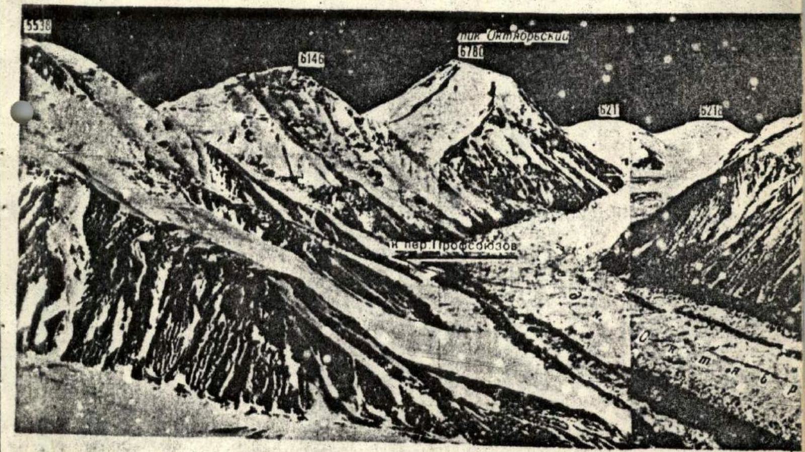
Brief Geographical Description
Comprehensive characterization of the expedition area
The Alay Valley, which we encountered on our way, stretches from the Tauk-Murun ridge (rooster's beak), merging with the low ridge of the Alay and Trans-Alay Ranges. From the foot of this ridge, 3378 m high, the Alay Valley stretches westward for 135 km. Between the foothills of both ranges, the valley widens from 8–10 to 20–22 km; its total area is 1600 sq. km. The lower part of the Alay Valley lies at an altitude of 2362 m near the village of Katty-Keramyk. The Kyzyl-Suu River, which we crossed via a reinforced concrete bridge, originates in the upper reaches of the Alay Valley beyond the Tauk-Murun ridge.
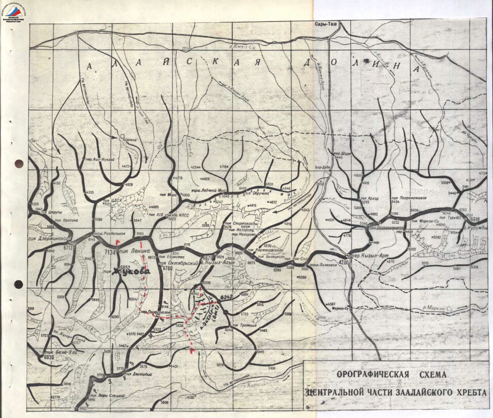
The Trans-Alay Range in its central part has the highest point — Peak Lenin (7134.3 m) and forms the northern border of the Pamir. This range stretches in a latitudinal direction for 150 km, borders on the east with the extreme western spurs of Kokshaal-Tau (Tien Shan), and tapers off on the west near the confluence of the Muk-Suu and Kyzyl-Suu rivers. The heavily glaciated northern slope of the range faces the Alay Valley, above the bottom of which, at an altitude of 6000–7000 m, rises its relatively unbroken crest.
Over a considerable extent, the average absolute heights of the Trans-Alay Range exceed 6000 m; the southern slope, facing the Pamir, rises 2000–2500 m above the bottom of the high-altitude valley in the extreme east of the range. In the upper reaches of the East Kyzyl-Suu River rises the trapezoidal peak "Zarya Vostoka" (6346 m). To its right — the huge snow massif of Kurumdy (6610 m), which means "Visible" in translation. Further to the right, opposite the village of Sary-Tash, above the deep gorge through which, according to old legends, the smugglers' trail passed, towers the pointed Peak "Pogranichnik" (5434 m). Further west of Peak "Pogranichnik" lies a fairly wide valley through which the Pamir Highway "Gory Korzhenevskogo" (highest point of the ridge 6075 m) passes, named after the tireless explorer of the Pamir. These peaks lie west of the Pamir Highway. The snow ridge "Gory Korzhenevskogo" almost immediately turns into the giant peak Kyzyl-Achyn or "Red Stream" (6679 m). From Kyzyl-Achyn extends the "Barricade Ridge", followed by Peak Lenin (7134.3 m). In the southern direction from the Kyzyl-Achyn peak are the objects of our ascents.
The slopes of the Trans-Alay Range are steep, cut by a system of short, wide valleys, closing with almost sheer walls of cirques. Numerous glaciers descend along the valleys.
Geological structure:
- The southern slope of the Trans-Alay Range is composed of Paleozoic deposits, adjacent to the north with a band of metamorphic schists.
- The axial part of the Trans-Alay Range and the southern slope of the western part are composed of Permian deposits.
The Oktyabrsky Glacier, lying on the southern slope, is one of the largest valley glaciers in Central Asia. It is rapidly disintegrating — melting. The tongue of the Oktyabrsky Glacier now constitutes 30.3% of the area it occupied in 1946.
The area of the Oktyabrsky Glaciers is the work site of our Krasnoyarsk expedition. To approach the southern slopes of the Trans-Alay Range, we had to:
- Cross the Alay Valley,
- Cross the Trans-Alay Range via the Kyzyl-Art Pass (elev. 4280.3 m),
- Traverse the Mark Walley (what means "valley of death"),
- Overcome the harsh climate of the high-altitude desert: average annual temperature — 8 °, average summer temperature — +5 °, annual precipitation — 40 mm.
At the 247th km of the Pamir Highway, we turn west into the valley of the Kara-Dzhilga River. From the Pamir Highway, the cars move along the terrible off-road and make their way directly to the terminal moraines of the Oktyabrsky Glacier (50 m). Here, at an altitude of 4200 m, next to the rampart of the terminal glacial moraine, we set up a base camp on the right (orographic) bank of the Kok-Sai River, flowing from the Oktyabrsky Glaciers.
The greatest difficulty lies in fording the Kok-Sai River. The wide floodplain of the Kara-Dzhilga River, where it meets the Kok-Sai River flowing from the north, also receives the waters of the Boygakshee River, which originates from the Volodarsky Glacier, and the Karoym River, which begins under the Karoym Pass from the south. Having replenished its muddy waters, the Kara-Dzhilga sweeps them away, breaking through from northwest to Lake Karakul.
The area of our work is characterized by a fairly low amount of precipitation. Apparently, that is why the vegetation here is scarce, and the area looks quite harsh and, at first glance, lifeless.
The path from the camp at the glacier tongue to the intermediate camp, which we set up on the moraine of the Oktyabrsky Glacier below the Profsoyuzov Pass, located in the Zulumart crest, takes 5–6 trekking hours. From here, the area of the unnamed peaks planned for ascents is visible. These peaks are located in a small spur extending in a southwest and then southeast direction from the peak Kyzyl-Agyn (6679 m).
The ridge has a number of peaks that are interesting from an alpinist's perspective, 40 of which are not included in the alpinist classification of peaks and descriptions of the KSP area.
To the east of the base camp, there is a classified peak — Pik Trapeziya (6048 m), located in the spur of the Trans-Alay Range. In the Zulumart Range, there are peaks previously climbed and representing interest for climbers from a sporting perspective: Pik Edinstva, Pik Oktyabrsky, etc.
In the gorge of the Boygakshee River, there are several interesting peaks, the most beautiful of which is the Pamir "Ushba" or Vera Slutskaya Peak (5910 m); its walls await their ascenders.
In conclusion, I would like to say that this area is very interesting in all sports respects and can serve for the training of high-altitude climbers.
Route Reconnaissance
When the objects of ascents on the unnamed peaks 6205 m and 6042 m were identified, we could not obtain exhaustive data on the climbing area. According to the map-scheme in the book "Pik Lenina" by V.I. Ratsek, Honored Master of Sports of the USSR, corresponding member of the Geographical Society of the USSR, we decided to conduct a reconnaissance of the approaches for successful ascents.
The peak 6205 m is located in a spur extending in a southwest and then southeast direction from the peak Kyzyl-Agyn (6679 m). From the available image in V.I. Ratsek's book, it was clear where the peaks were located.
On the map-scheme, the height indicated for one peak — 6042 m — is apparently plotted erroneously. Reconnaissance and on-site recce would provide complete clarity.
We acclimatized in this range.
According to Order No. 26 of July 26, 1978, and the implementation of the approved work plan of the expedition, it was necessary to:
- Set up an intermediate camp,
- Deliver necessary supplies and equipment,
- etc.
On July 26, the entire expedition team, 19 people (except for senior coach V. Svetlakov, who felt unwell — fell ill), set out on the route. Senior was appointed coach B. Bagaev. The path from the base camp to the intermediate camp on the Oktyabrsky Glacier passes along the right (orographic) side of the Kok-Sai River.
Previous expeditions have laid a clearly visible trail, which is practically impossible to lose. The trail follows the slope of the peaks, along the Zulus-Art ridge:
- Passing the Western Oktyabrsky Glacier,
- Further along the trail, traversing the slope, it enters the middle part of the Main Oktyabrsky Glacier.
Here, on a small moraine, we set up an intermediate camp at an altitude of 4700 m. The journey from the base camp to the intermediate one takes 4–5 hours. According to the tactical plan, the entire team was divided into two groups.
B. Bagaev's group was to conduct a reconnaissance of the approaches and paths to the unnamed peaks. V. Milko's group was to survey the approach to the Profsoyuzov Pass and make deliveries for the planned ascent to Peak Lenin via the Bolshaya Saukdara Glacier.
From the intermediate camp, Peak 6205 m and Peak 6042 m are clearly visible; both peaks are in the same spur, separated by a pass. This was confirmed after reconnaissance. Having identified the approach route under the peaks, on July 27, the group left the intermediate camp lightly loaded, with the intention of returning to the base camp on the same day.
The main task of the group was to find a passage to the eastern branch of the Oktyabrsky Glacier, flowing from the slopes of the peaks we had identified. Three hours later, we traversed the seracs and a small randkluft of the Main Oktyabrsky Glacier and found a path leading to the median moraine of the eastern branch of the glacier. Another two hours of walking along the moraine, and the group reached the upper part of the glacier. Further, the approach route was clearly visible. The task was accomplished, and the group returned to the base camp on the same day.