
Climbing Passport
I. Climbing type: technical II. Climbing area: Western Pamir, Mazarsy ridge, Mazar valley III. Peak, altitude, route: Peak Soviet Olympians (p. 5347) via the right buttress of the southern wall; name proposed by the first ascenders IV. Proposed difficulty category: 5B cat. diff., first ascent V. Route characteristics: height difference 1420 m, length – 1625 m (of which V and VI cat. diff. – 1425 m)
Steepness – 61°; in the lower and middle part of the route, there is no water for 850 m (in the second half of summer). VI. Number of pitons: 203 (rock pitons – 191, bolt pitons – 12), of which 33 for creating artificial anchors (ITO) VII. Number of walking hours: 74 h 30 min VIII. Number of bivouacs and their characteristics:
- August 2, 1978, 3920 m – on a ledge, normal, water available, preparation time – 1 h 20 min
- August 3, 1978, 4200 m – on a ledge, normal, no water, preparation time – 3 h
- August 4, 1978, 4550 m – on a ledge on the wall, sitting in a tent, no water, preparation time – 4 h
- August 5, 1978, 4700 m – on a ridge, semi-reclining, no water, preparation time – 2 h 30 min
- August 6, 1978, 4920 m – on a ridge, normal, water available, preparation time – 40 min
- August 7, 1978, 5100 m – on a ridge, normal, water available, preparation time – 1 h 40 min
- August 8, 1978, 4300 m – descent, on a ledge, in a couloir, sitting in a tent, no water, preparation time – 3 h
IX. Team leader: Makhonovich L.A. – Candidate Master of Sports
Team members:
- Ivanchin I.A. – Candidate Master of Sports
- Krivoruchenko V.S. – 1st sports category
- Kuzmin A.S. – Candidate Master of Sports
- Romanov A.A. – 1st sports category
X. Team coach:
- Penchuk V.L. – Master of Sports
XI. Date of departure and return: from August 2 to August 9, 1978
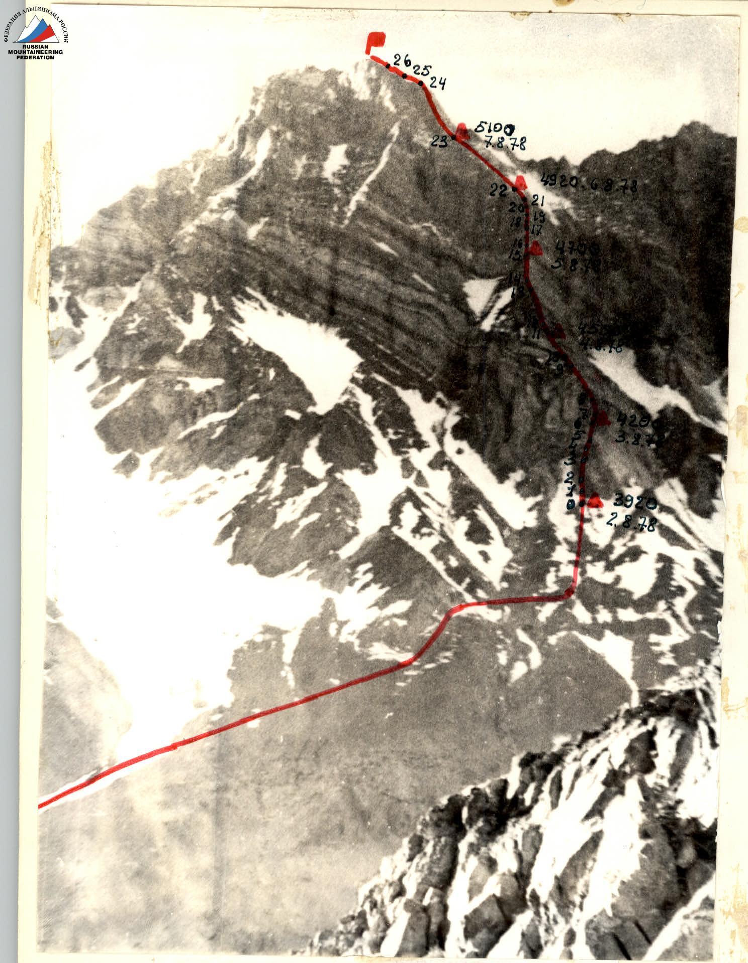
Peak Soviet Olympians (5347 m), route via the right buttress of the southern wall.
Geographical Description of the Area
The upper reaches of the Obi-Mazar river were chosen as the location for the mountaineering expedition for the second time. In 1974, an expedition from the Leningrad "Trud" society led by G.A. Chunovkin operated in this area. This team completed an ascent as part of the USSR mountaineering championship on Peak Arnavad Severny via the northeastern wall and took first place in the high-altitude technical climbing category.
The information obtained from the Leningrad mountaineers was deemed insufficient by the expedition leadership, and in early May of the same year, a reconnaissance trip was organized with three people to:
- study the access routes and approach to the base camp;
- choose a method for delivering goods to the base camp (helicopter or caravan option);
- conclude an agreement for further radio communication.
The second task of the reconnaissance was to gather additional photographic materials about possible climbing routes. The reconnaissance found that obtaining a helicopter was practically impossible, and a long journey (about 35 km) with goods on donkeys from Upper Sangvor (the confluence of the Obi-Mazar and Obi-Khingou rivers) to the confluence of the river from under the Arnavad glacier into Obi-Mazar was anticipated. The Leningrad team, on the other hand, reached the base camp by helicopter from Djirgatol and had a significant time advantage.
The Mazar valley is located between two ridges: the Darvazsky ridge (to the south) and the Mazarsy ridge (to the north). In the eastern part, the ridges converge, closing the valley. From here, one can access the Vanch valley through the Tekharvi, Arnavad, or Buna passes located in the Darvazsky ridge.
The Mazarsy glacier, located in the upper reaches of the valley, gives rise to the rather turbulent Obi-Mazar river, a left tributary of the Obi-Khingou river, which flows from the Garmo glacier. The Mazarsy ridge in this area is a continuous chain of peaks with heights ranging from 5200 to 5800 m. One of the peaks,
 Suraysha, was climbed in 1977 from the north from a neighboring valley by a team of Kharkov mountaineers as part of the USSR championship. Many of these peaks are interesting from a mountaineering perspective.
The southern slopes of the ridge drop into the valley with steep walls. In some places, there are cirques with hanging glaciers. The northern slopes of the Darvazsky ridge, on the other hand, are abundant with spurs, canyons, forming a tangled network of ridges, cirques, and small glaciers.
Two lateral valleys branch off to the south from the Mazar valley. One of them leads from the north to the Arnavad massif, forming a large cirque in the upper part, surrounded by peaks, most of which were to be climbed for the first time, as it was known that only Arnavad and Suraysha had been climbed, and a few other training routes of 1-2 categories that were not classified, and even the climbers themselves could not accurately identify the locations of these mountains. The second lateral valley leads to the first Arnavad pass. The Arnavad glacier, lying in the valley, gives rise to a full-flowing southern tributary of the Obi-Mazar river.
Just below the confluence of these two valleys, in a shaded aspen and birch grove, the base camp was set up. The peak that caught our attention, somewhat reminiscent of Peak Engels, was visible right above the base camp in the Mazarsy ridge and was later named Peak Soviet Olympians. 10 km downstream, a large tributary flows in from the left from the Darharvag valley. Halfway from Darharvag to our base camp, on the edge of a high and gradually crumbling cliff, stands a shrine with the sarcophagus of Hozrati Burkh ("Saint Burkh") – a place of pilgrimage for Muslims. On some days, up to 50 or more pilgrims would come here, so the trail was well-trodden, but it was still difficult for donkeys, and in many places it had to be literally cut out to ensure the passage of donkeys with cargo.
The journey uphill took a full 7 days. All participants had to shuttle back and forth because the number of donkeys was limited; this took a lot of effort and time but also allowed all participants to acclimatize well.
A suspension ropeway was set up across one of the tributaries flowing into Obi-Mazar from the Mazarsy ridge, and the entire cargo and participants were transferred across this ropeway, while the donkeys were eventually led across, empty, above the air crossing with great difficulty.
The return journey with donkeys took about 4 days + 2 days by bus on a fairly decent road. Before this, buses had not run on this road, so the driver was reluctant to drive. After 70 km of difficult road, the bus arrived in Tavil-Dara, and from there, it was a quick drive on asphalt to Dushanbe. The delivery and evacuation took just under 2 weeks, and this transportation method is unlikely to be recommended for subsequent expeditions to this area.
There are still many unclimbed peaks and unexplored cirques in the area where the expedition operated, such as:
- Darharvag;
- the cirque of the Arnavad glacier.
In the upper reaches of the Mazarsy glacier, most of the main peaks and the most interesting routes of 5B cat. diff. were climbed by participants of our gathering (5 routes of 5B cat. diff. + 4 training routes from 3B to 5A cat. diff.).
Table of Main Characteristics
| Date | Section | Avg. steepness, ° | Length, m | Terrain characteristics | Difficulty | Condition | Weather | Rock pitons | Ice pitons | Bolt pitons |
|---|---|---|---|---|---|---|---|---|---|---|
| August 2 | Processing sections R1–R4 of the wall for 5 h 30 min | |||||||||
| August 3 | R1 | 80 | 50 | Rock of blocky structure, inner corner | 5 | crumbling rocks | normal | 5 | – | – |
| R2 | 70 | 60 | Wall, yellow rocks with few holds and cracks | 5 | fragile rock | 6 | – | – | ||
| R3 | 80 | 60 | Inclined ledge on the wall (5–15 cm) | 5 | easily crumbling rock | 7 | – | – | ||
| R4 | 85 | 30 | Slab, smooth without holds | 6 | monolith | 3, 5 | – | – | ||
| R5 | 40 | 20 | Sharp ridge part of the buttress | 5 | fragile, easily crumbling rock, covered with dust. | 3 | – | – | ||
| R6 | 80 | 50 | Couloir | 5 | tile-like overhanging rocks | 6 | – | – |
Departure at 7:00. Bivouac stop at 16:00. Processing sections R7, R8 from 16:00 to 20:00. Preparation of the platform for the tent from 16:00 to 19:00. Normal bivouac. 270 m of the route was covered (including 200 m processed the day before), 35 pitons were driven, 5 of which were for passing section R4 on ladders. Hauling of backpacks on section R4. Total work time – 13 h.
| Date | Section | Avg. steepness, ° | Length, m | Terrain characteristics | Difficulty | Condition | Weather | Rock pitons | Ice pitons | Bolt pitons |
|---|---|---|---|---|---|---|---|---|---|---|
| August 4 | R7 | 70 | 65 | Wall, inner corner | 5 | tile-like rocks | normal | 6 | – | – |
| R8 | 80 | 60 | Wall | 5 | –"– | 5 | – | – | ||
| R9 | 50 | 200 | Sharp ridge part of the buttress | 5 | fragile, easily crumbling rock, covered with dust. | 16 | – | – | ||
| R10 | 80 | 30 | Ridge ascent | 5 | –"– | –"– | 6 | – | – | |
| R11 | 60 | 60 | Sharp ridge part of the buttress | 5 | –"– | –"– | 5 | – | – |
Departure at 7:00. Bivouac stop at 18:00. Processing section R12 from 18:00 to 21:00. Preparation of the platform for the tent from 18:00 to 22:00. Bivouac on a ledge, sitting. Total work time – 15 h. 415 m of the route was covered (including 125 m processed the day before). 38 pitons were driven.
| Date | Section | Avg. steepness, ° | Length, m | Terrain characteristics | Difficulty | Condition | Weather | Rock pitons | Ice pitons | Bolt pitons |
|---|---|---|---|---|---|---|---|---|---|---|
| August 5 | R12 | 100 | 12 | Wall on the buttress with negative steepness | 6 | smooth wall with easily crumbling rock | normal | 2, 9 | – | – |
| R13 | 60 | 80 | Sharp ridge part of the buttress | 5 | fragile, easily crumbling rock, covered with dust. | 7 | – | – | ||
| R14 | 90 | 8 | Wall on the buttress | 6 | smooth wall with easily crumbling rock | 2, 1 | – | – | ||
| R15 | 70 | 60 | Sharp ridge part of the buttress | 5 | fragile, easily crumbling rock, covered with dust. | 7 | – | – |
Entry onto the route at 9:00. Bivouac stop at 16:00. Processing sections R16, R17 from 16:00 to 20:30. Preparation of the platform from 16:00 to 18:30. Semi-reclining bivouac. Total work time – 11 h 30 min. 160 m was covered. 28 pitons were driven, including 10 rock pitons for movement on ladders. Backpacks were hauled on sections R12 and R14.
| Date | Section | Avg. steepness, ° | Length, m | Terrain characteristics | Difficulty | Condition | Weather | Rock pitons | Ice pitons | Bolt pitons |
|---|---|---|---|---|---|---|---|---|---|---|
| August 6 | R16 | 90 | 20 | First wall of the "bastion" | 6 | monolithic vertical wall without holds | normal | 4, 8 | – | – |
| R17 | 90 | 50 | Second wall of the "bastion" | 5 | monolithic wall with cracks, easily crumbling ledge in the upper part | 9 | – | – | ||
| R18 | 100 | 10 | Red slab | 6 | monolith | – | – | 2, 4 | ||
| R19 | 80 | 30 | Grey slab | 6 | –"– | 4 | – | 1 | ||
| R20 | 80 | 30 | Ledge on the wall | 6 | easily crumbling, loose rock | 6 | – | – | ||
| R21 | 100 | 10 | Overhanging part of the wall | 6 | monolithic but soft rock | 2 | – | 5 | ||
| R22 | 50 | 100 | Ridge part of the buttress | 4 | jagged, easily crumbling ridge | 4 | – | – |
Entry onto the route at 7:00. Stop for bivouac at 21:00. Normal overnight stay. Total work time – 14 h. 250 m was covered. 49 pitons were driven, of which:
- for movement on ladders – 8 rock pitons and 10 bolt pitons. Backpacks were hauled on sections R16–R22.
| Date | Section | Avg. steepness, ° | Length, m | Terrain characteristics | Difficulty | Condition | Weather | Rock pitons | Ice pitons | Bolt pitons |
|---|---|---|---|---|---|---|---|---|---|---|
| August 7 | R23 | 50 | 250 | Ridge | 5 | jagged, easily crumbling ridge | normal | 23 | – | – |
Departure at 9:00. Bivouac stop at 16:00. Processing section R24 from 16:00 to 20:00. Normal bivouac. Total work time – 11 h. 250 m of the route was covered. 23 pitons were driven.
| Date | Section | Avg. steepness, ° | Length, m | Terrain characteristics | Difficulty | Condition | Weather | Rock pitons | Ice pitons | Bolt pitons |
|---|---|---|---|---|---|---|---|---|---|---|
| August 8 | R24 | 70 | 150 | Pre-summit wall | 5 | monolithic but light rock | normal | 22 | – | – |
| R25 | 30 | 40 | Ridge | 4 | jagged rocks, easily crumble | 1 | – | – | ||
| R26 | 50 | 30 | Gendarme | 5 | slab-like structure | 4 | – | – | ||
| R27 | 45 | 60 | Summit ridge | 4 | jagged rocks | 3 | – | – |
Departure onto the route at 8:00, reaching the summit at 12:30.
- Pitons driven: 30
- Time taken to ascend: 4 h 30 min
- Distance covered: 280 m
- Total route length: 1625 m
- Height difference: 1420 m
- Average steepness: 61°
- Total ascent time: 74 h 30 min
- Total pitons driven: 203, of which 12 were bolt pitons
- Descent took: 19 h
- Number of rappels on descent: 14, each 60 m long
Brief Explanation of the Table of Main Characteristics
August 2. Processing of the 200-meter lower wall, sections R1–R4. Normal overnight stay at the initial bivouac. Water is available in the stream to the left of the direction of travel, about 100 m away. Further along the route, in the lower and middle parts, there is no water. We collect 4 liters of water for subsequent movement along the route.
August 3. Section R1. The beginning of the section is in the left part of the wall, about 20 m up. Then, via yellow rocks, straight up towards the center of the wall (photo №6). Section R2. Movement straight up to a platform convenient for receiving people and organizing belays. Here, the yellow rocks end, and the grey massif begins. The end of the second section and the start of the third are shown in photo №7. Section R3. Movement left and upwards. The center of the wall remains about 25–30 m away, but it is not passable directly. It is necessary to traverse the left part of the wall with a gain in height along small ledges and shelves on the wall (photos №7 and №8) to a smooth slab, where the central part of the wall is accessed. Section R4. Grey smooth slab, almost vertical, with few cracks, passed straight up using artificial holds (photo №9). Backpacks are hauled. Section R5. Sharp ridge part of the route, extremely difficult to navigate. Rocks are fragile, covered with dust. The principle of movement is similar to that on snowy or icy ridges, but complicated by the lack of convenient footholds. Additionally, driving pitons is challenging due to the fragility of the rock. Here and elsewhere on the route, ice titanium pitons and long "crutches" were used. Due to the above reasons, movement on sections R6–R8 was conducted along the right (in the direction of travel) part of the buttress, slightly below the ridge. Section R6. Descent from the ridge to the right along a ledge into a steep, upward-sloping couloir. The couloir has a tile-like microrelief. The leader cleans the route, making it relatively safe to follow. The couloir ends at an outcrop where a platform for a tent can be organized. The pair proceeds to process the further route while one team member remains to set up the bivouac. The slope's steepness at the platform is 35–40°, but the rocks are soft and can be processed, allowing for a normal overnight stay to be established within 3 hours. By evening, 120 m of the further route (sections R7 and R8) are processed.
August 4. Section R7. From the tent, move along the ledge up and to the right for 10 + 12 m, then up the wall towards the inner corner. The rock structure is tile-like, and everything is cleaned. The inner corner turns left at the top and ends at a bridge between the wall and the outcrop to the right. Section R8. A wall section leading to the ridge part of the buttress. The exit is near a group of rocks resembling "ram's foreheads." Section R9. Sharp ridge part of the buttress. Movement is on top or on all fours, with insurance using ice pitons directly into the rock, with mandatory duplication of pitons at the end of the rope. Section R10. Steep ridge ascent. There are no bypass options; it is taken head-on. The rock is very loose; footholds are cleaned of dust and then hammered into the rock. Section R11. Sharp ridge part of the buttress, similar to section R9. After this section, there is a negative wall that cannot be overcome "in stride." We are forced to stop for the night on the right slope of the buttress, about 20 m below the wall (photo №10). Processing the wall and organizing a sitting bivouac continued late into the evening.
August 5. In the morning, we drank the last gulp of water and continued. The lack of water is increasingly felt. Section R12. The negative wall on the ridge of the buttress is passed on the right side using ladders. Only ice pitons are used, with duplication and utmost caution. After the wall, the ridge continues with even greater steepness. Section R13. Sharp ridge section of the buttress. Section R14. An eight-meter wall, resembling an open book. The first climber stands on the shoulders of the second and hangs a ladder, climbs up, and moves to the left part of the "book." Section R15. Again, a sharp ridge part of the buttress. Ends with an exit to the key section of the route, the so-called "bastion" – a 150-meter overhanging wall. Before the wall, there is a platform that is turned into a comfortable semi-reclining bivouac over several hours. The leading pair processes the "bastion." The remaining two rappel down to the left from the buttress to fetch water.
ATTENTION! This operation can only be conducted after 18:00 when the slopes of the huge bowl-shaped couloir cease to be illuminated by the sun, and the rockfall danger decreases to reasonable limits.
August 6. Section R16. The first wall of the "bastion" is slightly offset from the main rock massif and is climbed directly using ladders. At the top of the wall, the first station for hauling backpacks is organized (photo №11). Further movement is carried out as follows: the leading pair passes the next section and moves on, while the trio ensures the hauling of backpacks stage by stage, from station to station, along the entire path through the "bastion." Section R17. Movement through the "bastion" upwards to the right under the overhang to a protruding red slab. Section R18. A 10-meter red slab extending upwards to the right with monolithic rock is passed using bolt pitons and ladders (photo №12). The bolt pitons are reusable and are screwed into the rock, creating a smooth load on the wall around the hole (ordinary driven bolt pitons destroy the rock and come loose). After the section, there is a station for receiving backpacks. Section R19. A grey slab is passed similarly to section R18, only slightly easier (photo №13). There is a station for hauling backpacks. Section R20. A ledge on the wall, partially destroyed in places. The general direction of movement is upwards to the right. Backpacks are received. Section R21. A 10-meter overhanging wall section. Passed using ladders and reusable bolt pitons. Section R22. The first relatively easy section on the route (4 cat. diff.). Movement is not along the ridge but slightly below – along the right part. Normal overnight stay. For the first time since the fourth day on the route, there is water nearby.
August 7. Section R23. The ridge part of the route; the ridge is heavily jagged. It is advisable to move slightly below the ridge along the right side; although it's more challenging, it significantly saves time. We proceed to the summit wall, process it, and stop for the night. Tomorrow is the decisive day.
August 8. Section R24. The summit wall, monolithic soft rock, is taken head-on. Section R25. The ridge part of the route; rocks are of medium difficulty. Movement is to the right of the ridge. Section R26. A gendarme. A relatively non-steep section, but the rocks are overhanging, slab-like. Movement is either directly or by bypassing to the right, with equal difficulty. Section R27. The exit to the summit; rocks are of medium difficulty. There is no note on the summit. This fact, along with prior familiarity with the area and consultation, confirms that we have achieved a first ascent.
Descent:
- we begin by following the ascent route (up to section R15);
- then (after 18:00), we continue the descent into the right (in the direction of descent) couloir;
- on a ledge, we organize a sitting bivouac;
- at 6:00 on August 9, we traverse horizontally to the left, cross the buttress in the area where section R9 ends, and descend into the left (in the direction of descent) couloir, passing the rockfall-prone section before it is illuminated by the sun.
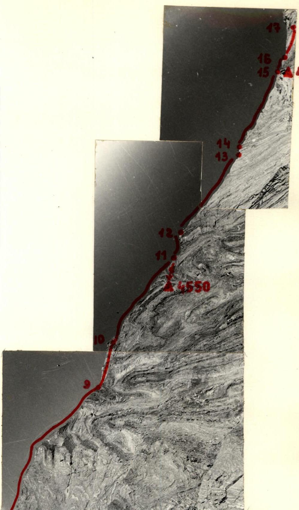
Photo №4. Profile shot of the middle part of the route (sections R9–R17).
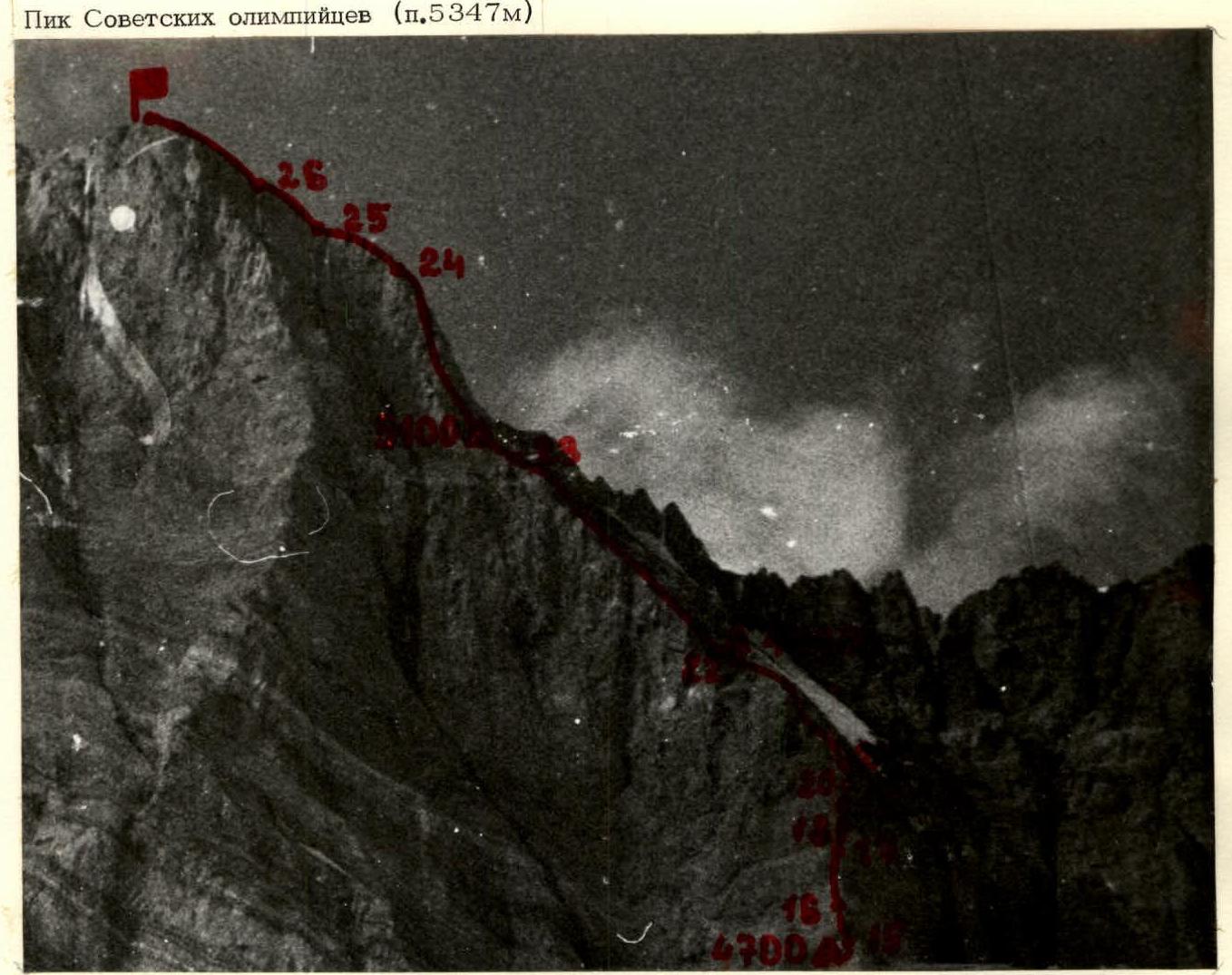
Photo №3. Profile shot of the lower part of the route (sections R1–R9).
Photo №5. Profile shot of the upper part of the route (sections R15–R27).

Photo №8. Passage of section R3.
I. General Characteristics of the Route
The route via the right buttress of the southern wall is a rock massif shaped like an inverted integral with alternating bands of yellow and grey rocks, resembling a waffle (clearly visible in frontal and profile photographs). Both types of rock are very soft: the yellow is more crumbled, while the grey typically has few holds and cracks. There are no reliable places for driving pitons; everything is covered in dust. Holds are first cleaned of dust, and then hammered into the rock. Pitons are reliable only if they are ice pitons or long special "crutch" pitons. In the report, the term "rock piton" is conditional: 80% of the pitons used on the route were ice pitons and special "crutches" about 18 cm long. 20% were steel thick rock pitons. In the absence of cracks, the soft rock allows the use of only reusable bolt pitons, which smoothly load the rock when screwed in. Driving ordinary bolt pitons destroys the rock around the hole.
The route consists of four walls, approximately 150–200 m high, connected by sharp ridge sections of the buttress. The steepness of the wall sections is 70–100°, and the ridge sections are 50–70°. The ridge sections are no less challenging to navigate than the wall sections (the ridge has a vertical drop to the west and a 50–80° slope to the east). The width of the ridge is 0.05–0.5 m.
The key section of the route is the "bastion" (sections R16–R21). In the middle part of the "bastion," there is an overhang. There is no water in the lower and middle parts of the route (850 m of the path to the "bastion").
II. Recommendations for Passing the Route
Equipment:
- main ropes: 2–3, 60–80 m long;
- auxiliary rope: 1, 60–80 m long;
- ice titanium pitons and "crutches": 25–30 pcs;
- steel rock pitons (12 cm long, 4–5 mm thick): 10–15 pcs;
- general carabiners: 20–24 pcs.
Two- and three-step ladders: 3–4 pcs. Reusable bolt pitons: 15–20 pcs.
Provisions:
- food for 8–10 days, at 0.5–0.6 kg per person per day, with a caloric content of at least 2500 kcal.
- water: 6–8 liters per group of 5–6 people. Total backpack weight – 10–12 kg.
Passage of wall sections in Vibram shoes or similar footwear. Water is available in the couloir to the left of the direction of travel when approaching the "bastion." To acquire it, one must rappel about 60 m down, then traverse about 100 m horizontally. Descent into the couloir is only possible after 18:00. When descending from the summit via the first ascenders' route, note that:
- after passing the "bastion," descent into the right (in the direction of descent) couloir is possible after 18:00;
- further descent via the left couloir is safe until it is illuminated by the sun.
Alternatively, the descent can be made from the summit along the western ridge.
According to the team, the ascent of Peak Soviet Olympians via the right buttress of the southern wall has no analogues among the routes they have climbed. In terms of the complexity of the rock relief, the route is comparable to Dykh-Tau (via the Georgians), Peak Kommunisticheskoy Akademii, and any route on Tash-Tam-Bek-Torbashi, and the soft nature of the rocks, difficulty of organizing belays, and lack of water further increase the difficulty and complexity of the ascent. According to the team's assessment and the coaching council, the route undoubtedly deserves a 5B category of difficulty.
Comments
Sign in to leave a comment