

Vanch Range
UNNAMED PEAK 5231 m (previously 5211)! (FIRST ASCENT) VIA WEST RIDGE ROUTE APPROXIMATELY CATEGORY 5A DIFFICULTY
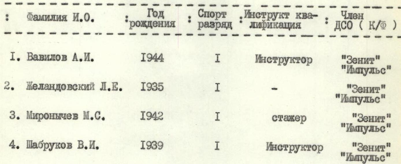
Team Composition
| Name | Sport Rank | Role |
|---|---|---|
| Vavilov A.I. | 1st sport rank | — team leader |
| Zhelandovskiy L.E. | 1st sport rank | — participant |
| Mironychev M.S. | 1st sport rank | — " — |
| Shabrukov V.I. | 1st sport rank | — " — |
Gorky, 1976
Map-Scheme of Vanch Region

Legend to the map-scheme: A/L "Vysotnik", intermediate base camp, path of the assault group, backup descent route.
From August 3 to September 1, a group of climbers from the Gorky Regional Council of the DSO "Zenit" conducted sports training at the Vysotnik alpine camp on the Central Pamir.
The goal of the training was to improve the athletes' skills and organize an ascent for the CS DSO "Zenit" championship.
Brief Characteristics of the Region
The Vysotnik alpine camp base was located in the upper reaches of the Vanch valley, near the left-bank moraine of the Geographical Society glacier.
The region is very interesting for climbers, with many peaks in the nearby ranges and spurs that have not been climbed before.
The slopes of the ranges are steep: inaccessible valleys with glaciers at the headwaters have slopes of 1500–2000 m.
They are composed of Lower Paleozoic crystalline and sedimentary rocks. The weather is stable in summer, with an average July temperature of +22 °C. Annual precipitation at an altitude of 1800–2000 m is 160–220 mm. The vegetation is semi-desert. Along the riverbeds on the cones and terraces, there are dense thickets (tugai) of willow, sea buckthorn, birch, and poplar.
Above 2500 m, the semi-desert vegetation zone gives way to tall grasses and mixed steppes. The fauna is relatively poor. Characteristic animals include the mountain goat (kiik), brown bear, snow leopard, and lynx, and birds such as the uлар and stone partridge.
The location of the base camp is very convenient for organizing ascents to the peaks of the Darvaz, Vanch, Yazgulem ranges, and the Academy of Sciences range.
Peak 5231 m is visible from the base camp and is one of the most beautiful peaks in the region. It had not been climbed by climbers before.
I. Training Process
THE CLIMBING TEAM, upon arrival at the high-altitude base of the Vysotnik alpine camp, began to implement a pre-compiled plan of training and sports work, which included a cycle of training sessions on rock and ice-snow techniques, as well as a training ascent to Peak Krasnoarmeytsev (category 3A difficulty).
To familiarize themselves with the region and undergo active acclimatization, the team planned sports ascents to:
- 5025 m, category 5A difficulty (successfully completed);
- 5200 m (Peak Cherepovets) via the center of the north face (first ascent, approximately category 5B difficulty) — the group returned from the route due to bad weather.
II. Route Reconnaissance
From August 2 to 13, the sports group led by Vavilov completed an ascent to 5025 m — category 5A difficulty. During the ascent, they observed Peak 5231 m (Peak Khrustalny).
On August 20, they conducted a reconnaissance of the West Ridge's condition, outlined an approximate route, and planned a movement schedule. It was established that:
- the northern slopes of the ridge are very steep and fairly solid;
- the southern slopes are heavily damaged;
- to the south of the West Ridge, another ridge leads to the summit, apparently very challenging.
To the left of the ridge lies a wide, rockfall-prone couloir, beyond which other ridges lead to the summit, but they are not of significant sporting interest due to their severe degradation and erosion.
The height difference is 1700 m, with an average steepness of 50°. The descent route was planned via Peak 5025 m or the saddle between Peaks 5231 m and 5416 m.
III. Organization of the Base Camp
During the reconnaissance, the location of the base (intermediate) camp was determined. The camp was set up on the right bank of the Dustiroz River, near a stream flowing from the slopes of Peak 523 m, a 6-hour walk from the Vysotnik alpine camp. The bivouac site is picturesque and convenient, providing good conditions for overnight stays.
IV. Organization of Interaction and Communication
The group was equipped with a "Vitalka" radio station. The upper third of the route is visible from the base camp, allowing for direct communication. To communicate with the "base," interaction was established with groups:
- from Voronezh, with the call sign "Chuk";
- from Donetsk, with the call sign "Don-I," climbing Peak 5025 m.
Later, radio stations with the following call signs were used:
- "Artem" — for the group ascending Peak 5231 m via the north face;
- "Artem-I" — for the observation group monitoring "Artem," maintaining constant communication with the base.
This organization of interaction and communication enabled constant monitoring of the assault group's location and the ability to provide assistance quickly if needed.
Ascent Plan by Days
Day 1 — Approach and setting up camp near the confluence of the stream and the Dustiroz River. Route reconnaissance. Days 2–4 — Completing the route. Day 5 — Reserve day for bad weather. Equipment preparation.
The route utilized standard equipment received at the Vysotnik alpine camp, as well as a set of titanium rock pitons and clamps, ensuring reliable safety insurance on all sections of the route and relatively quick progress.
All participants had down gear and high-altitude, crampon-compatible boots and galoshes.
List of Used Equipment
Group equipment:
- "Pamirka" tent — 1 pc.
- Main rope 40 m — 2 pcs.
- Auxiliary rope 40 m — 1 pc.
- Carabiners — 20 pcs.
- Rock pitons — 18 pcs.
- Ice pitons — 4 pcs.
- Bolt pitons — 4 pcs.
- Bolts — 2 pcs.
- Ladders — 3 pcs.
- Rock hammers — 2 pcs.
- "Shmel" primus stove — 1 pc.
- Gasoline — 2.6 l
- "Vitalka" radio station — 1 pc.
- Autoclave — 1 pc.
- Pot — 1 pc.
- First aid kit — 1 set
- Crampons — 2 pairs
Total weight of group equipment: 29.6 kg.
Personal equipment:
- Down suit — 4 sets
- Woolen suit — 4 sets
- Woolen sweater — 4 pcs.
- Down mittens — 4 pairs
- Canvas mittens — 4 pairs
- Helmets — 4 pcs.
- High-altitude boots — 4 pairs
- Sunglasses — 5 pcs.
- Climbing harnesses — 5 pcs.
- Ice axes — 4 pcs.
Nutrition
When selecting food, the group considered the individual tastes of the participants and the available supplies at the Vysotnik alpine camp base. The food was high-calorie, easily digestible, and vitamin-rich. The group had a 6-day food supply on the route, weighing 17.3 kg in total.
Team Composition
The participants have sufficient experience in climbing in the Caucasus, Tian Shan, and Pamir-Alai, including first ascents and first traverses on the Central Pamir. The group has been climbing together for three consecutive seasons. Three of the four team members arrived at the Vysotnik alpine camp after working or interning at Caucasian climbing camps.
The team members know each other well from joint training sessions and climbs.
| Name | Year of Birth | Sport Rank | Instructor Qualification | Member of DSO (K/F) |
|---|---|---|---|---|
| Vavilov A.I. | 1944 | 1st sport rank | Instructor | "Zenit" "Impulse" |
| Zhelandovskiy L.E. | 1935 | 1st sport rank | — | "Zenit" "Impulse" |
| Mironychev M.S. | 1942 | 1st sport rank | Trainee | "Zenit" "Impulse" |
| Shabrukov V.I. | 1939 | 1st sport rank | Instructor | "Zenit" "Impulse" |
Route Description
August 23, 1953. Departure at 4:00. Pack up the bivouac; after breakfast, at 5:00, we leave the campsite. We move along the Dustiroz River bank to two large boulders, then ascend steep grassy slopes into a couloir and continue up the couloir to the "black rocks." To the right of the "black rocks" lies a ledge. We rope up before the ledge. The rope teams are Vavilov — Zhelandovskiy and Mironychev — Shabrukov. The initial section features fairly solid rocks. We ascend 80 m via an inner corner, with a steepness of 70°. The upper part involves difficult climbing with piton protection. On the ledge, the group reunites and then ascends a 30 m wall with a steepness of 75°, reaching the ridge and completing R1. Time: 7:30.
We continue along the ridge, staying on the left side. The right side is heavily damaged and rockfall-prone; the ridge is very narrow, with an average steepness of 50°. Protection is via pitons and rock outcrops. We hammer in 11 pitons. At times, the climbing is difficult, and the backpacks are cumbersome. We approach a steep wall along the ridge. Here, we take a break. R2 is complete. Time: 12:30. It's possible to set up a bivouac here — there's snow.
We then approach a gendarme with a western face that is a steep, trapezoidal rock face. The right part of the face is heavily damaged; the left upper part of the ridge drops off to the north with smooth, polished slabs. The average steepness of the face is 75–80°, spanning 200 m. The climbing is very challenging; we traverse the face on a double rope, using artificial holds and ladders. The backpacks are cumbersome. We hammer in 27 rock pitons. The section takes 6 hours.
On the summit of the tower, we build a cairn. We then continue along the ridge for another 2 hours to a stream. We set up a bivouac by the stream, constructing a platform for the tent out of rocks. Time: 20:00. Total pitons driven for the day: 43.
August 24, 1953. Departure at 5:00. At 6:00, we continue along the ridge. The average steepness of the ridge is 30–50°, with walls of 60–70° steepness over 20–30 m sections. Movement is alternating, with protection via outcrops and pitons. The presence of "live" rocks demands extra caution during movement and belaying.
After traversing a slope with walls (150 m), we move along a damaged, not-too-steep part of the ridge (150 m) and approach a jagged section with a steepness of 50°. We move simultaneously (200 m) on a full rope length, securing it to outcrops. We approach a snow-ice slope along the ridge. The section is completed in 4 hours, with 6 rock pitons driven.
Next, we ascend the snow-ice slope with a steepness of 60°. The first climber ascends in crampons with piton protection over 40 m and sets up vertical fixed ropes. We ascend via the fixed ropes onto the snow-ice slope. The slope is constantly exposed to falling rocks. Rocks fall randomly and unpredictably!" The section is very dangerous! We traverse the slope to the right (40 m) toward the rocks. Along the ridge, without entering the snow, we approach a gendarme consisting of three steps. The first and second steps are ascended directly. The third step is climbed first to the right along a 40 m ledge, then left up a steep inner corner (40 m), exiting into a gendarme crack, and then onto the ridge. The section is complex, requiring constant attention. Protection is via pitons.
We continue along a non-steep snowfield toward a double-toothed gendarme of very light-colored rock. Near the gendarme is an excellent rock "mulda" just larger than the tent. We set up a bivouac here. Time: 19:00.
The rocks surrounding the tent protect it from the wind. We construct a level area for the tent and melt snow for water. On the second day, we drive 16 rock pitons and 3 ice pitons.
The summit is less than a 30-minute walk away. We review possible descent routes.
August 25, 1953. Departure at 6:00. We review the descent options again and decide on descending via the couloir leading from the saddle on the south ridge of Peak 5231 m. At 7:00, we begin the ascent to the summit. The ridge leading to the summit has a steepness of 25° and is uncomplicated. Movement is simultaneous. We reach the summit at 7:30. We leave a note for the first ascenders and build a cairn.
We examine the descent route along the East Ridge, which leads into the Abdukagor valley above the Medvezhiy glacier. However, the descent via the hanging glacier's icefall appears problematic.
At 8:00, we begin our descent to the bivouac site. We dismantle the bivouac and head toward the couloir. The couloir is steep but can be descended "on foot." Caution is necessary due to numerous "live" rocks. The couloir's slopes are shaded until the afternoon, so an early start is recommended.
Traversing the scree slopes of the couloir to the left and crossing small ridges, we reach a small stream flowing from the slopes of Peak 5416 m. We cross the stream and ascend a grassy slope on the left bank, which ends in steep "ram's foreheads" dropping into the valley.
We set up two sport rappel ropes and continue along the stream bank toward the Dustiroz valley.
After organizing three rappel points, we descend to the Dustiroz River bank and follow it downstream to our first bivouac site under the route. We bivouac here. The descent from the summit to the river took 8 hours. The total time for the third day was 12 hours and 30 minutes.
August 26, 1953. At 9:00, after packing up the bivouac, we headed to the base camp. At 13:00, the group successfully completed the ascent of Peak 5231 m and returned to the Vysotnik alpine camp base.
Table of Main Characteristics of the Ascent Route
Ascent route: Unnamed Peak 5231 m via the West Ridge.
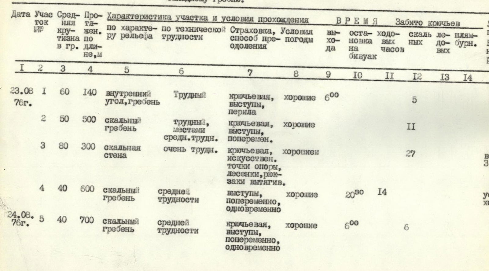
| Date | Section | Avg. Steepness | Length, m | Characteristics of the Section and Climbing Conditions (by Relief Type) | Technical Difficulty | Protection, Method of Climbing | Weather Conditions | Departure Time | Bivouac Stop Time | Climbing Hours | Rock Pitons Driven | Ice Pitons Driven | Bolt Pitons Driven | Bivouac Conditions, Weight of Daily Rations |
|---|---|---|---|---|---|---|---|---|---|---|---|---|---|---|
| 23.08.1953 г. | R1 | 60° | 140 | Inner corner, ridge | Difficult | Piton protection, outcrops, fixed ropes | Good | — | 7:30 | — | 5 | — | — | — |
| R2 | 50° | 500 | Rocky ridge | Difficult, местами средней трудности | Piton protection, outcrops, alternating | Good | — | 12:30 | — | 11 | — | — | — | |
| R3 | 80° | 300 | Rocky wall | Very difficult | Piton protection, artificial holds, ladders, cumbersome backpacks | Good | — | 18:30 | 6 | 27 | — | — | Weight 3.5 kg | |
| R4 | 40° | 600 | Rocky ridge | Medium difficulty | Outcrops, alternating, simultaneous | Good | — | 20:00 | 14 | — | — | — | Conditions good | |
| 24.08.1953 г. | R5 | 40° | 700 | Rocky ridge | Medium difficulty | Piton protection, outcrops, alternating, simultaneous | Good | — | 6:00 | 6 | 6 | — | — | — |
| R6 | 50° | 300 | Snow-ice ascent | Medium difficulty | Piton protection, fixed ropes, outcrops, alternating | Good | — | 19:00 | 3 | — | 3 | — | — | |
| R7 | 55° | 400 | Stepped, rocky gendarme | Difficult | Piton protection, fixed ropes, alternating | Good | — | 19:00 | 10 | 16 | — | — | Weight 4 kg | |
| 25.08.1953 г. | R8 | 25° | 300 | Summit ascent, rocky ridge | Easy | Simultaneous | Good | — | 7:30 | — | — | — | — | Conditions good |
Team Captain: (Vavilov) Team Coach: (Sidorov)
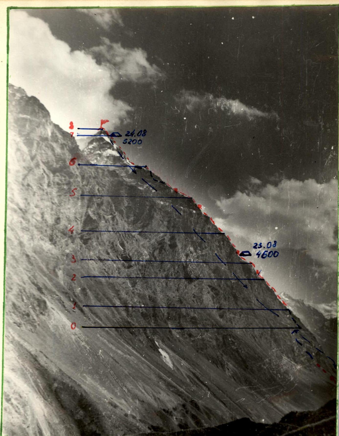
View of Peak 5231 m from the Dustiroz Valley
Legend: — Visible path — Invisible path Bivouac on August 23, 1953 (5200 m)
Comments
Sign in to leave a comment