REPORT ON THE FIRST ASCENT OF PEAK ROVANG (4796 m) VIA THE NORTH-WEST COUNTERFORT OF THE WEST RIDGE, APPROXIMATELY 4B CATEGORY OF DIFFICULTY.
Peak Rovan'g is located in the northern spur of the central part of the Vanchsky ridge in the upper reaches of the left tributary of the Rovan'g-Dara river. The peak is visible from the village of Garmchashma. It is a partially snow-covered rocky massif, significantly higher than the pass points in the ridge, has 3 not very pronounced peaks and several counterforts extending to the North-West. To the North, a rib extends, dividing the Rovan'g-Dara river gorge into two branches.
DESCRIPTION OF THE APPROACH TO THE ROUTE
From the village of Garmchashma along the road up to the Rovan'g-Dara gorge. Before reaching the fork in the gorge, cross to the left (orographically) bank of the river (until mid-July - via a snow bridge) and, ascending along the grassy rib, reach the "letovka". From the village, it takes 2-2.5 hours. Then, traverse left along the grassy slope to the left tributary of the Rovan'g-Dara river and along the tributary to the moraine, bypassing 3 canyons along steep grassy and clayey slopes with rocky outcrops. On the moraine, a place for a tent is cleared, and an overnight stay is set up. Water is available under the snow to the left and right of the moraine. From the village, it takes 7-8 hours. On the approach, it is advisable to wear crampons (steep grassy slopes, lack of trails, hard clay-pebble ground).
Route Description
From the overnight stay, ascend along the moraine to a rocky outcrop - the start of the route.
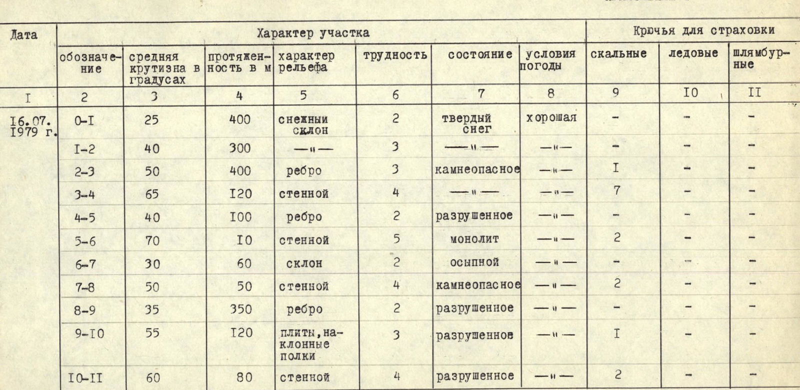
Along a snowy slope of moderate steepness (section R0-R1), ascend left upwards to the right of a large triangular wall. Further (section R1-R2), along a steep snowy slope (in some places ice, step cutting required) to the base of a narrow counterfort. Along the counterfort (section R2-R3), ascend (protection via protrusions) to a small saddle. On the saddle, there is a control cairn. Do not enter the snowy couloir to the left of the counterfort - it is prone to rockfall!
From the saddle, ascend right upwards for 2 ropes along steep smooth rocks (pitons!) - exit to the West Ridge in a "sag". Further upwards along the outer corner (pitons!) for 1.5-2 ropes (section R3-R4) and along the ridge (section R4-R5) - under the wall of a gendarme (section R5-R6).
The wall is climbed "head-on" (8-10 m, pitons!), then:
- traverse right upwards to the ridge (section R6-R7);
- under a rocky ascent (section R7-R8, 25-30 m).
Along a steep inclined ledge (pitons!) right upwards, then upwards to the ridge (control cairn, snow cornice to the left) and along the ridge (section R8-R9) with small gendarmes (climbed "head-on" or to the right along ledges, pitons!) - ascent under a heavily destroyed rocky ascent.
The rocky ascent (section R9-R10) is climbed to the right along inclined slabs and ledges. Further along a not very pronounced steep inner corner to the right of the ridge (section R10-R11) - exit to the summit tower (loose rocks!). From the overnight stay, it takes 9-10 hours.
Descent is via the ascent route. On section R11-R10 - sport climbing, then on section R9-R8 - descend from the ridge along a steep couloir left downwards and along scree ledges and a wide couloir along the ridge, descend to the "sag" in the ridge. Ascend to the "sag" along an inclined ledge, from the "sag" 2 abseils to the saddle of the counterfort and downwards along the counterfort via the ascent route. From the summit to the overnight stay, it takes 4-4.5 hours.
Appendix 1
Ascent Passport
- Ascent class - technical
- Ascent area - northern spur of the central part of the Vanchsky ridge
- Peak - Peak Rovan'g (local name), height 4796 m, route - via the North-West counterfort of the West Ridge
- Estimated category of difficulty - 4B
- Route characteristics:
- height difference - 1100 m
- length of sections:
- 2nd category of difficulty - 910 m
- 3rd category of difficulty - 820 m
- 4th category of difficulty - 250 m
- 5th category of difficulty - 10 m
- average steepness - 40°
- Number of pitons used for protection - 15 rock pitons
- Number of climbing hours - 9.5
- Route completed without overnight stays on the route
- Climbers:
- Leader - Vladimir Anatolyevich Lelyakov - 2nd sports category.
- Participants:
- Vladimir Ivanovich Evstifeev - 1st sports category.
- Alexander Yuryevich Podkaminer - 1st sports category.
- Team coach - Master of Sports of International Class Alexander Stepanovich Demchenko
- Departure to the route and return from the route on July 16, 1979
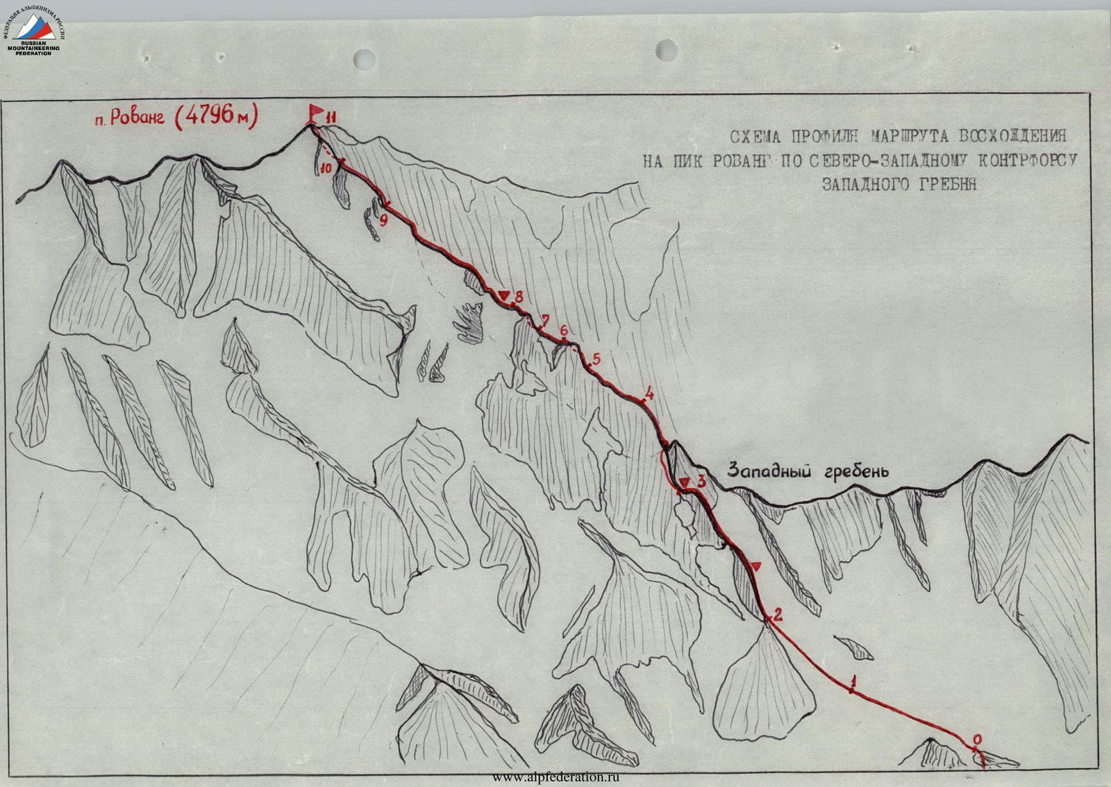 Profile diagram of the ascent route to Peak Rovan'g via the North-West counterfort of the West Ridge
Appendix 2