4.2.16
Report
Ravok East. Group of climbers SK A-18 SibVO on the first ascent to the peak 5223 m via the eastern ridge, route approximately category 3B.
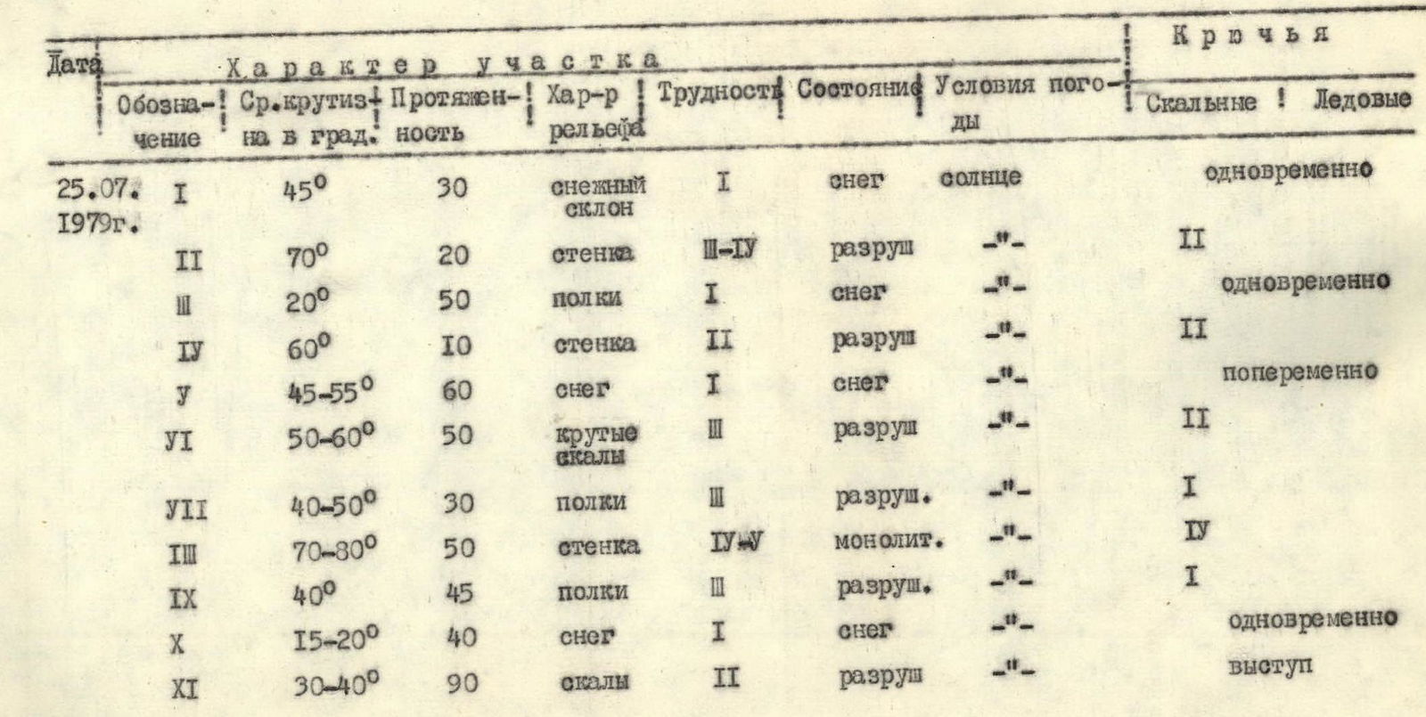
Table of main characteristics of the ascent route.
Map of the ascent area.
 Ascent and descent route.
Route description.
From the base camp, down the road to the Ravak River (1 hour walking). Then along the right (orographic) bank of the Ravak River into the eponymous gorge. Further, via snowfields and moraines consisting of small and medium-sized stones, exit to the snowy plateau of the cirque of peaks. The travel time is 4-5 hours. Bivouac.
The route begins at the foot of the peak with overcoming a pre-peak crevasse along an avalanche chute. It is recommended to start the route early in the morning, as rockfall from the peak wall is possible, as well as from the left from the spurs of the Cherepovets peak. Movement in teams on snow, to the left of the rocky island, then to the right of the avalanche chute upwards to the snowy saddle between p. 5223 m and p. Cherepovets. The distance along the snowfield is 600-700 m, covered in 4-5 hours, and in the second half of summer, above the rocky island, dense firn and ice are possible for up to 40-50 m (insurance via ice screws, crampons). Exit to the saddle to the left of the overhanging snow-ice cornices to the north, which are partially collapsed. The last 300 m of the snowfield are overcome alternately, with insurance via ice axe. Bivouac on the saddle is possible either on snow or on stones. Exit from the bivouac to the eastern ridge, first on snow at 45°, then on steep rocks (70°). 20 m upwards (shout), then traverse left to a ledge 15 m. Climbing is of medium difficulty; rockfall is possible due to the friable structure of the rocks. Then, bypassing the protruding rock to the left (first sentinel) along the snow along the rocks. Further along the rocks (insurance, hook) at 60° to the right - exit to the ridge and along it 30 m to the second sentinel. Control cairn. Further, 60 m of steep snow at 45-55° and exit along the ridge to the third sentinel (attention, snow cornice to the right). Then movement along the ridge, simple rocks, 40 m, the first "finger" is bypassed to the right along the snow, the second "finger" is bypassed to the left along a ledge. The height of the "fingers" is 5-8 m. Then 50 m straight up steep rocks, climbing of medium difficulty, steepness up to 50°-60° (insurance, hook) and exit to the fourth sentinel straight up 30 m along ledges and snow at 40°-50°. The exit itself has a snow-firn wall 2-3 m high. Then 40 m down via rope descent and through a "finger" 8 m high - approach to the key section of the route - a wall 50 m high at 70°-80° steepness. Directly from the ridge along a crack 6 m (wedge, chockstone), then through an inclined ledge into a chimney (10 m), with accreted ice and snow, a second ledge with lying stones (attention!). And further, insurance is possible through a protrusion. Then left upwards 15 m along rocks and then along a snowy ridge at 40° steepness, 30 m upwards, further along rocks to the top of the fifth sentinel. Further along the ridge, a 12 m sports descent, then 40 m along snow at 15°-20°, bypassing a "finger" to the left along ledges and 90 m along rocks to the left - exit to the sixth sentinel. Then along a gentle section of snow (attention, cornice to the right!), then along rocks 70 m, steepness up to 70°, exit to the summit along steep snow 15 m. Cairn. Descent is possible via two options:
- along the ascent route and takes 7-8 hours to the bivouac below the route;
- along the southern ridge, descent into the DUSTIREZ river gorge, via the Medvezhiy glacier, along the road to the base camp - 10-11 hours.