Ascent Passport
- Ascent class: Training.
- Ascent area: NW Pamir, spurs of the Darvaz Range.
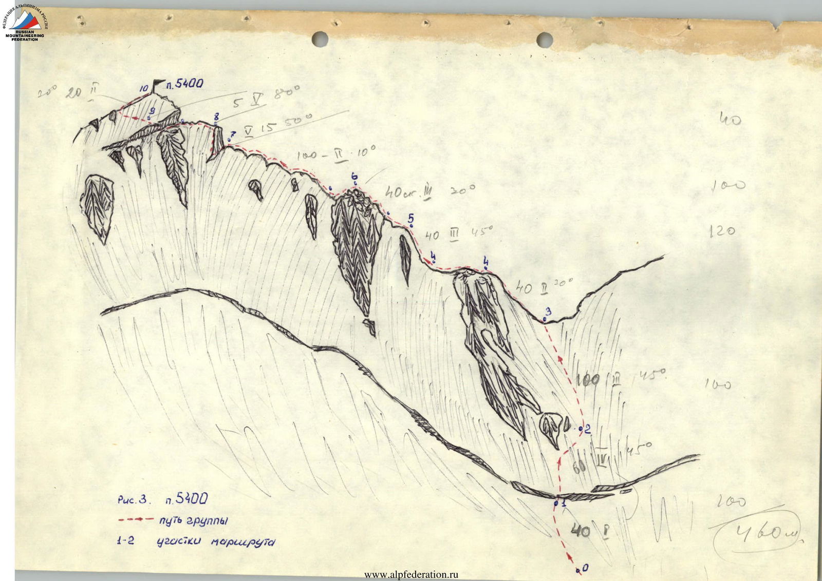
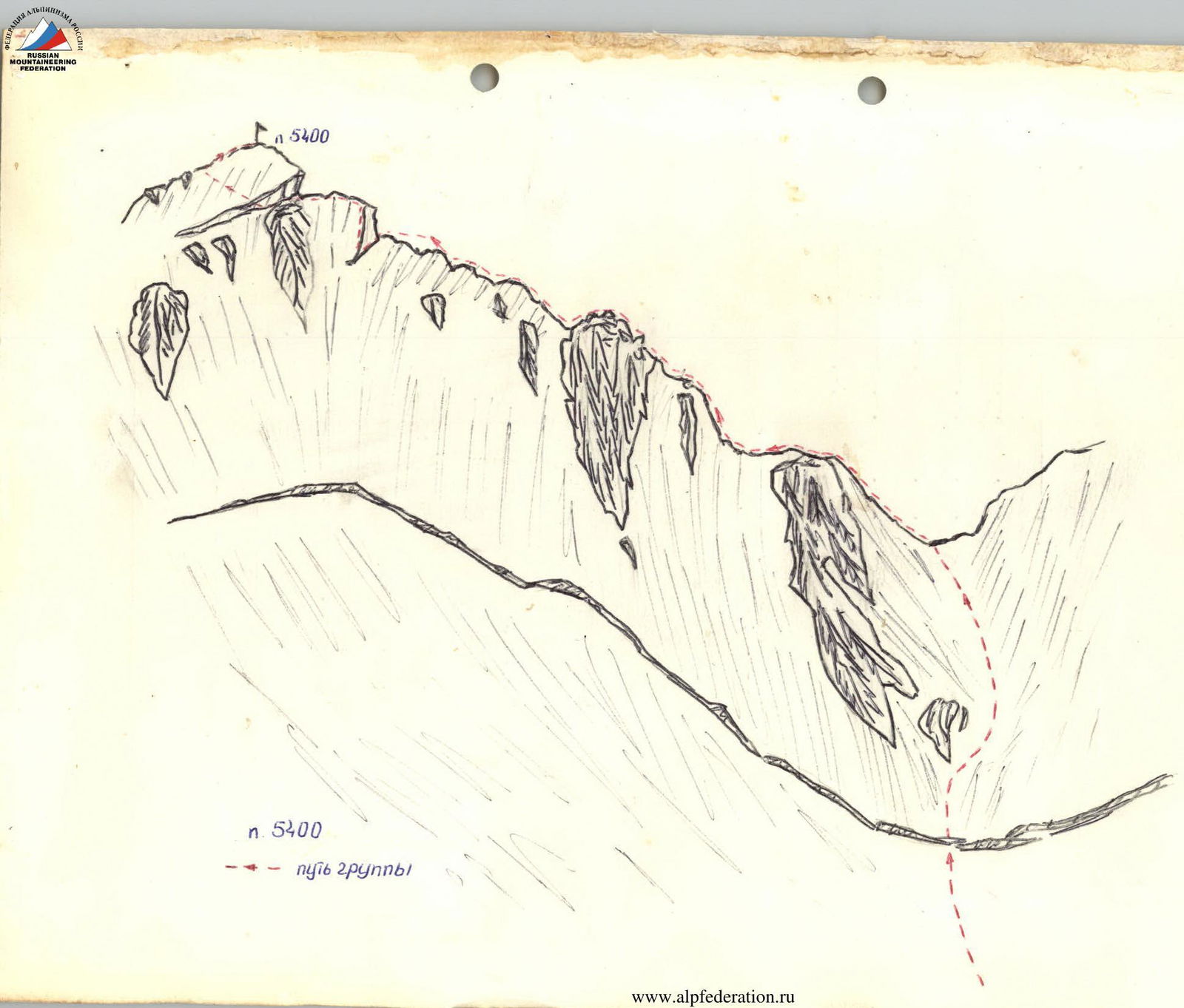
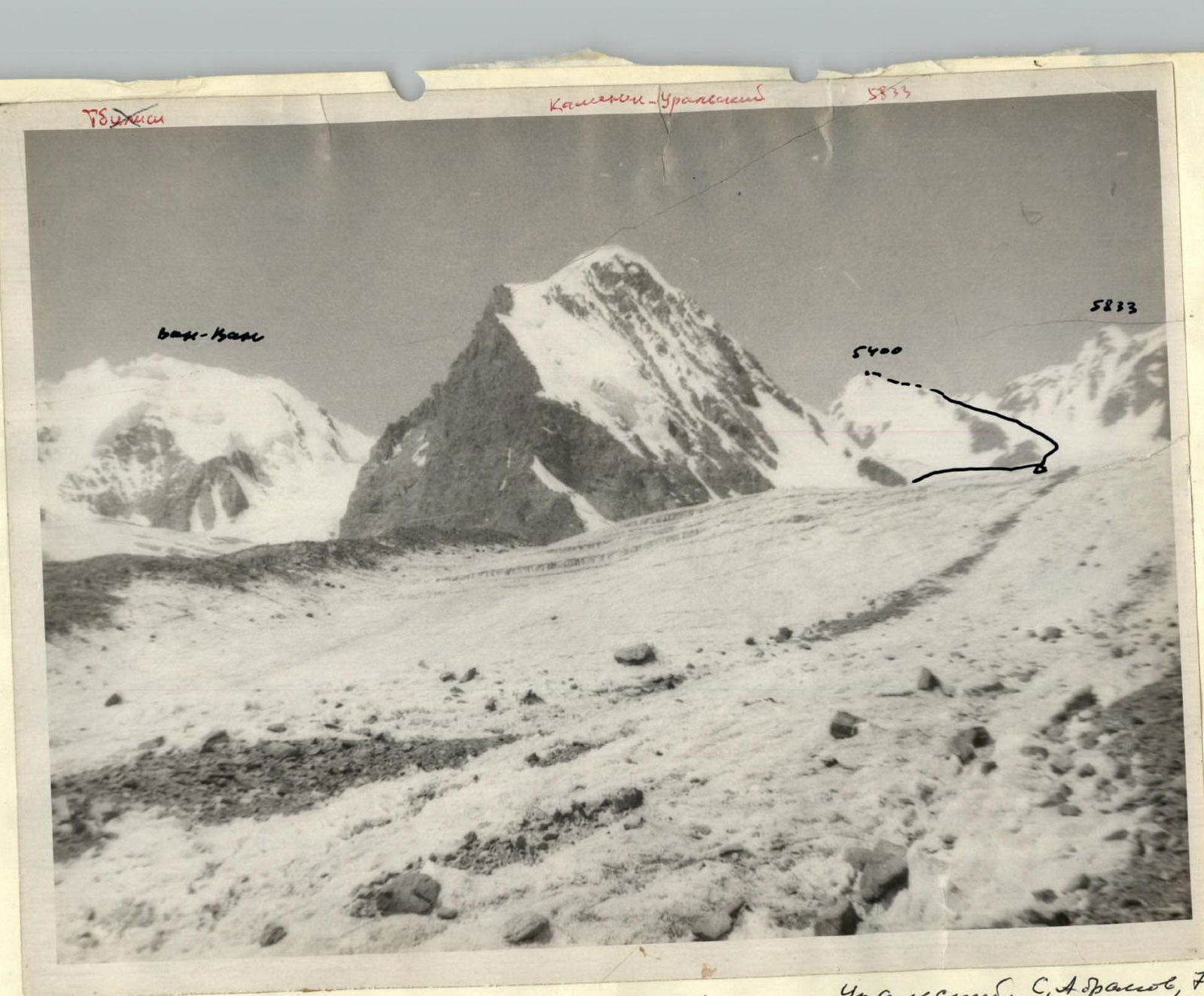
- Peak, its height, ascent route: p. 5400 (p. Ledovyy, name is conditional) via the north-eastern ridge.
- Estimated difficulty category: 3B cat. diff.
- Route characteristics:
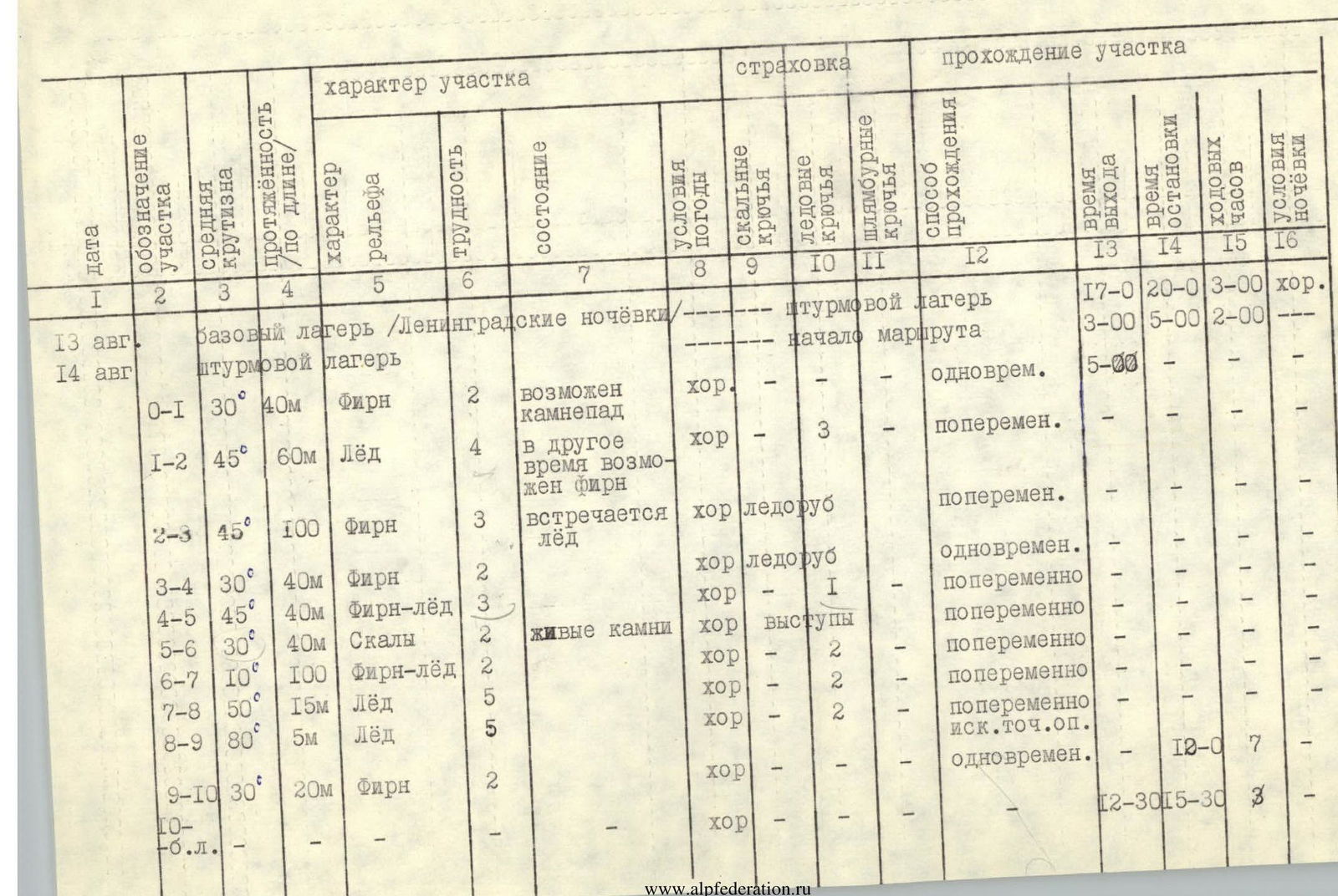
- height difference 600 m.
- average slope 40°
- length of sections with 5 cat. diff. – 20 m.
- Number of pitons driven for belaying, for creating artificial holds:
- rock: —
- ice: 9
- bolt: —
- rock: —
- ice: 1
- bolt: —
- Number of climbing hours: 7 h
- Number and characteristics of bivouacs: —
- Full name of the leader, participants and their qualification:
- Bogomaz V.V. — 1st sports category/leader
- Trifonova V.L. — 1st sports category
- Kazak G.F. — 1st sports category
- Braverman V.V. — 1st sports category
- Suvorkina L.D. — 1st sports category
- Team coach: Bezzubkin V.V.
- Date of departure and return: August 14, 1976
Brief geographical description and sports characteristics of the ascent object
The Geographical Society Glacier is located in the upper reaches of the Vanch River valley (100 km from the settlement of Vanch). From the north, G.S.G. receives a fairly large tributary, the Komsomolsky Glacier, in the basin of which our ascent object, p. 5400 (p. Ledovyy), is located. The peaks of the Komsomolets cirque began to be explored quite recently, and routes of various difficulty categories have already been completed: Peak 5962 via 4 and 5 cat. diff., p. Kamensk-Uralsky and p. Van-Van via 4 cat. diff., and others.
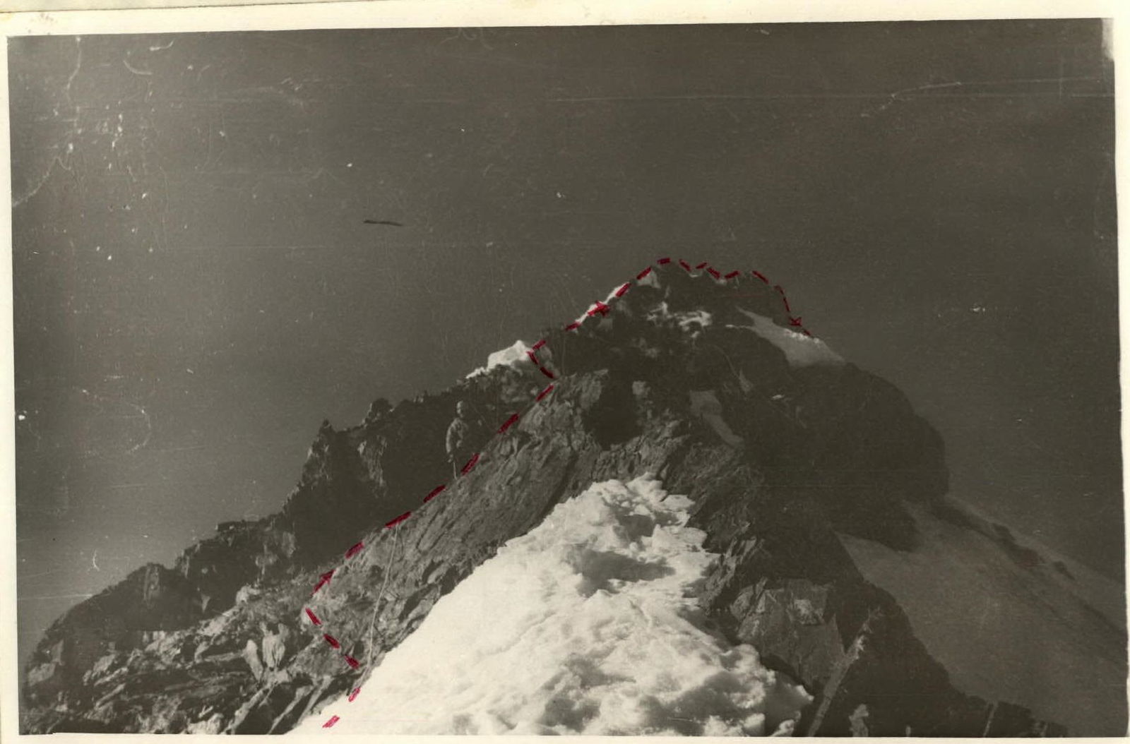
Peak 5400, located in the upper reaches of the Komsomolsky Glacier in the Darvaz Range, had not been conquered until now due to its remoteness. It is a snow-ice dome, to the summit of which two ridges lead from the Komsomolsky Glacier: the north-eastern ridge — our group's route, and the south-eastern ridge corresponding to 3 cat. diff. in terms of difficulty. However, the route from the north-eastern ridge is more logical and interesting, which is why it was chosen by us.
The weather in the G.S.G. area is quite stable; during the 30-day gathering (August), there were only 2–3 "non-climbing" days. The approach from the "Vysoтный" alpine camp to the Komsomolsky Glacier is quite challenging, as it requires gaining a considerable height (about 2 km).
We recommend ascending the Komsomolsky Glacier, and in particular the conquered p. 5400, for training and acclimatization. The routes here are diverse: wall routes (p. Kamensk-Uralsky on 4B), snow routes on Van-Van, ice routes on p. 5400, combined routes on p. 5962, and so on.

Description of the route passage
From the "Vysochnik" alpine camp along the Geographical Society Glacier to the Komsomolsky Glacier, and along it to the "Leningrad bivouacs" under the Kamensk-Uralsky Peak. 9 h of climbing time.
From the bivouacs along the Kamensk-Uralsky Peak to the icefall, 1 h. Crossing the icefall 30 min., then along the closed glacier to the south-eastern ridge of p. 5400, bivouacs under the icefall (1 h 30 min).
From the bivouac through the icefall to the middle of the p. 5400 glacier, then along the closed glacier to the start of the route (2 h).
Along a gentle firn slope (R0–R1) to the bergschrund, which is passed via a snow bridge, from the bergschrund, bypassing a rock island, along an ice slope (pitons for belaying, R1–R2) to the firn, and along it to a saddle (R2–R3). Belaying via a driven ice axe.
From the saddle, a gentle snow ascent (R3–R4), a large platform, a control cairn, then a steep snow ascent, ice in the upper part (R4–R5). Exit under a rock gendarme (R5–R6), movement along it, many loose rocks. From the gendarme, movement along the ice ridge, which consists of three humps, bypassed on the right (R6–R7).
Approach to the pre-summit ice wall, which is passed along the left edge (R7–R8), pitons for belaying.
Further along the ridge to the summit ice wall (R8–R9) with a slope of 80°, 5 m, which is passed using artificial holds and chopping ice.
To the summit leads a gentle snow ridge. A cairn is located slightly lower, on a rock outcrop.
Descent via the ascent route.
An early start on the route is recommended, as sections R1–R2 and R0–R1 are exposed to rockfall.
The ascent was made at the end of the season; at the beginning of the season, there may be no ice on sections R1–R2 and R4–R5.