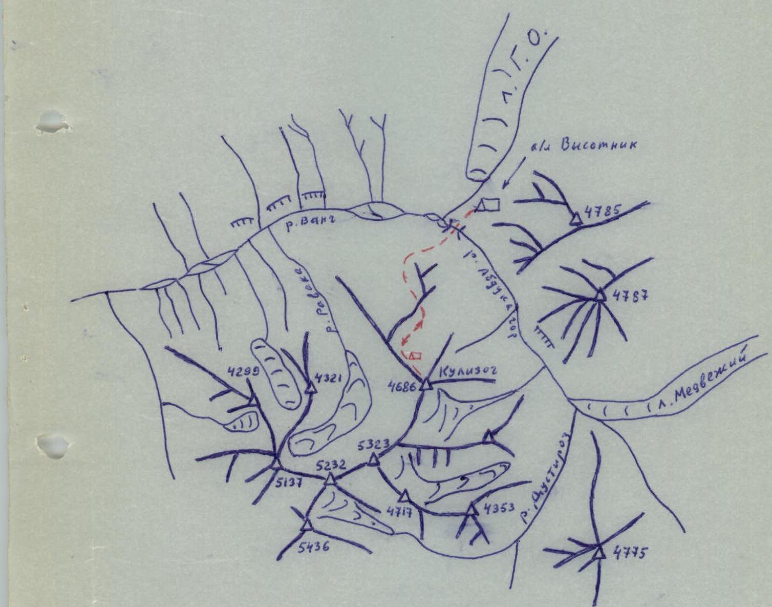
The peak Kulizog (4688 m) is located in the Northwest Pamir in the upper reaches of the Vanch River, in the northern spur of the Vanch Ridge. The Kulizog peak is the easternmost in a group of five peaks (p. 4321 m, p. 5137 m, p. 5232 m, p. 5323 m, and Kulizog peak) that frame a horseshoe-shaped glacier feeding the Rovak stream, a tributary of the Vanch River. To the east flows the Abdukagor River.
The first topographic survey of the area was conducted by N.G. Dorofeev in 1928. A more detailed topographic survey was carried out in 1949 by a group of topographers and glaciologists led by R.D. Zabirov.
The few mountaineering expeditions that have worked in this area have chosen objects on:
- the northern and middle parts of the Geographical Society glacier (G.O.);
- the area of the Fedchenko glacier;
- the Abdukagor River valley.
The first attempt to conquer Kulizog peak was made on August 2, 1972, by a group of climbers from the USSR Armed Forces: V. Golaktionov - leader, D. Tsamay, G. Chubinidze, A.M. Es'kin, V.A. Es'kin - from the upper reaches of the Rovak River. The group left their bivouac on the slope of the Rovak River at 8:00 and, reaching the first large gendarme, left a note by 15:00. The group did not reach the summit.
Description
Ascent to Kulizog peak (4686 m) via the northern ridge
A group of climbers from the LGS DSO "SPARTAK" gathering, consisting of:
- SILIN B.M. - 1st sports category, leader
- STEPANOV V.N. - 1st sports category
- GOLENETSKII S.V. - 1st sports category
- IGNAT'EV N.M. - 1st sports category, coach, observer
from the "VYSOOTNIK" alpine camp base, made an ascent to Kulizog peak (4686 m) on August 15, 1974, via the northern ridge.
The peak and the route along the ridge are clearly visible from the base camp. The northern ridge approaches the confluence of the Abdukagor River with the river flowing from the Geographical Society glacier.
The approach to the route from the "VYSOOTNIK" base camp takes 15-20 minutes.
The route begins with an ascent up a grassy slope to a green shoulder of the ridge and then traverses the shoulder to the left and upwards (2.5 hours). Then, it descends into a wide scree couloir leading to a depression in the northern ridge of Kulizog peak.
The exit to the depression in the ridge from the couloir is via a snowy slope of moderate steepness, to the left of a double-humped gendarme. From the base camp to the depression in the ridge takes 7-8 hours.
It is also possible to approach the depression in the ridge behind the double-humped gendarme by staying on the ridge without descending into the scree couloir. This variant does not require losing altitude, but the rocky ridge proves to be significantly more challenging than it appears, and overall, it takes 2-3 hours more. Moreover, on this detour, when approaching the depression, piton belays are required.
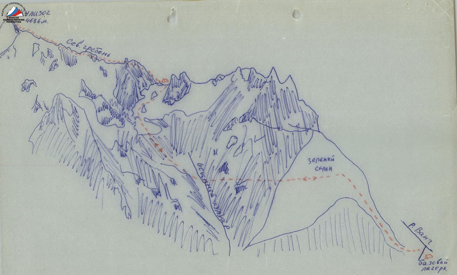
The northern ridge is quite sharp, representing a series of consecutive gendarmes. The rocks are heavily destroyed. Belays are made through ridge outcrops. On the ascent, most gendarmes can be bypassed, mainly to the right, along scree ledges with alternating belays through outcrops and pitons.
"Be cautious of live rocks!!!"
Bypassing the second gendarme:
- It is better to bypass.
- It is mandatory to organize thorough piton belays in combination with belays through outcrops, as the mountain's rock is not solid.
- Pitons and outcrops are not entirely reliable.
"Maximum caution!!!"
The ascent to the pre-summit ridge is via a steep rocky-snowy ascent on the ridge. The ascent is made from left to right. It is essential to move from left to right, as there are cornices on the left. The movement is on a full rope. Belays are made through an ice axe. Alternating movement.
From the pre-summit:
- slightly to the right through a small depression
- exit to the summit with a broad snow dome located to the left.
The ascent from the depression in the ridge to the summit takes about 5 hours. The ridge is 1200-1300 m long. The average steepness of the ascent to the gendarmes is 30°. On the route, 8 pitons are hammered.
The descent along the ascent route is equally laborious and takes almost as much time as the ascent. On the descent, it is safer to go on a shortened rope. From the depression in the ridge to the base camp, the descent takes about 3 hours.
The route is climbed with one overnight stay. Possible overnight locations:
- in the upper part of the scree couloir;
- at the depression in the ridge;
- on the ridge between gendarmes.
Climbing conditions in the area
A. Weather conditions
Weather conditions are determined by the location of the area in the center of the Northwest Pamir. Like in the entire Northwest Pamir, the weather is unstable. The average amount of precipitation in the Vanch River valley is greater than in any other Pamir region. However, in the summer, there is little precipitation on peaks up to 6000 m.
During the gathering, 4 fronts of bad weather with heavy cloudiness and winds were noted. At the same time:
- Constant flags formed on the peaks.
- Visibility on the routes was completely lost.
However, there were practically no snowfalls, and therefore, the avalanche danger did not increase.
B. Approaches and altitude differences
All expeditions working on the G.O. glacier and at the "VYSOOTNIK" alpine camp in 1974 had their base camp at the tongue of the G.O. glacier. This is a convenient location, directly accessible by car. There are no higher locations suitable for a base camp. However, the tongue of the G.O. glacier has an altitude of 2600 m. For the Pamir, this is a very low altitude. The altitude difference is very significant, and the initial acclimatization is very low.
C. Relief features
There is a lot of ice in the area. Practically all northern slopes are ice walls. The natural steepness of the ice slope in the area is higher than in the Caucasus. The ice is very dense. All this leads to many challenging and interesting ice routes. The entire Vanch Ridge and its spurs are composed of sedimentary rocks, some of which are very fragile.
Considering the complexity of the approach to the route, the length of the ridge, and the nature of the relief, this route can be classified as category 3B, as a good training route for this area, where most peaks consist of heavily destroyed rocks.