270530
Report
8
ON THE FIRST ASCENT OF KOMURZANG PEAK (4653 m) VIA THE WEST RIDGE, APPROXIMATELY CATEGORY 3B DIFFICULTY
Komurzan Peak is located in the northern spur of the central part of the Vanch Range. It is clearly visible from the Vanch River valley between the villages of Sungat and Garmchashma. It is a triangular peak with moderately pronounced counterforts between the West and Northwest ridges. A large snowfield lies between these ridges, transitioning into a canyon.
Approach to the Route Description
From the base camp in the Vanch River valley between the villages of Garmchashma and Sungat, proceed to the West ridge and follow it to the "letovka" (3–3.5 hours). Continue along the ridge with rock outcrops to the start of the ridge ascent (3–3.5 hours) — the overnight location. A tent site can be prepared on the ridge; snow is available on the northern slope, but there is no water.
Route Description
From the overnight location, ascend the severely damaged rock ridge with small (2–5 m) walls to the red wall (section R0–R1, 1.5–2 hours). Movement is simultaneous, with insurance through ledges at certain points. At the base of the red wall, there is a control cairn on a platform (rockfall hazard!).
The red wall (section R1–R2) — 1.5 ropes — is traversed on the right side, with an exit to the left at the top ("live" rocks, pitons!). There are no convenient locations for organizing insurance on this section.
Above the wall, exit onto a ledge and then proceed to the 1st gendarme (section R2–R3). Traverse the 1st gendarme on the left with a slight ascent; ascend the 2nd gendarme directly (piton!), then traverse left. Before the 3rd gendarme (section R3–R4), descend to the right onto a connecting ridge, then proceed to the right of the gendarme along a narrow ledge (piton!) to avoid the gendarme, reaching a talus ledge. Ascend a steep talus ledge to a snow-covered ridge with a slope of 30–35°.
Follow the left part of the ridge to approach a steep snow couloir. In the couloir (section R4–R5), move in three steps, chopping steps, with insurance via an ice axe. At the top of the couloir, exit left to a rocky ridge crest (piton!), then transition to the right and upwards to a steep rocky ridge (section R4–R5) with small wall sections. Do not descend to the snowfields on the left of the ridge — avalanche hazard! Ascend the ridge to the summit. The journey from the control cairn takes 6–7 hours.
Descend via the ascent route. On section R5–R4, use three sport routes, and on section R2–R1, use two rappels. The descent from the summit to the overnight location takes 4–5 hours.
Diagram of the central part of the Vanch Range
With northern spurs
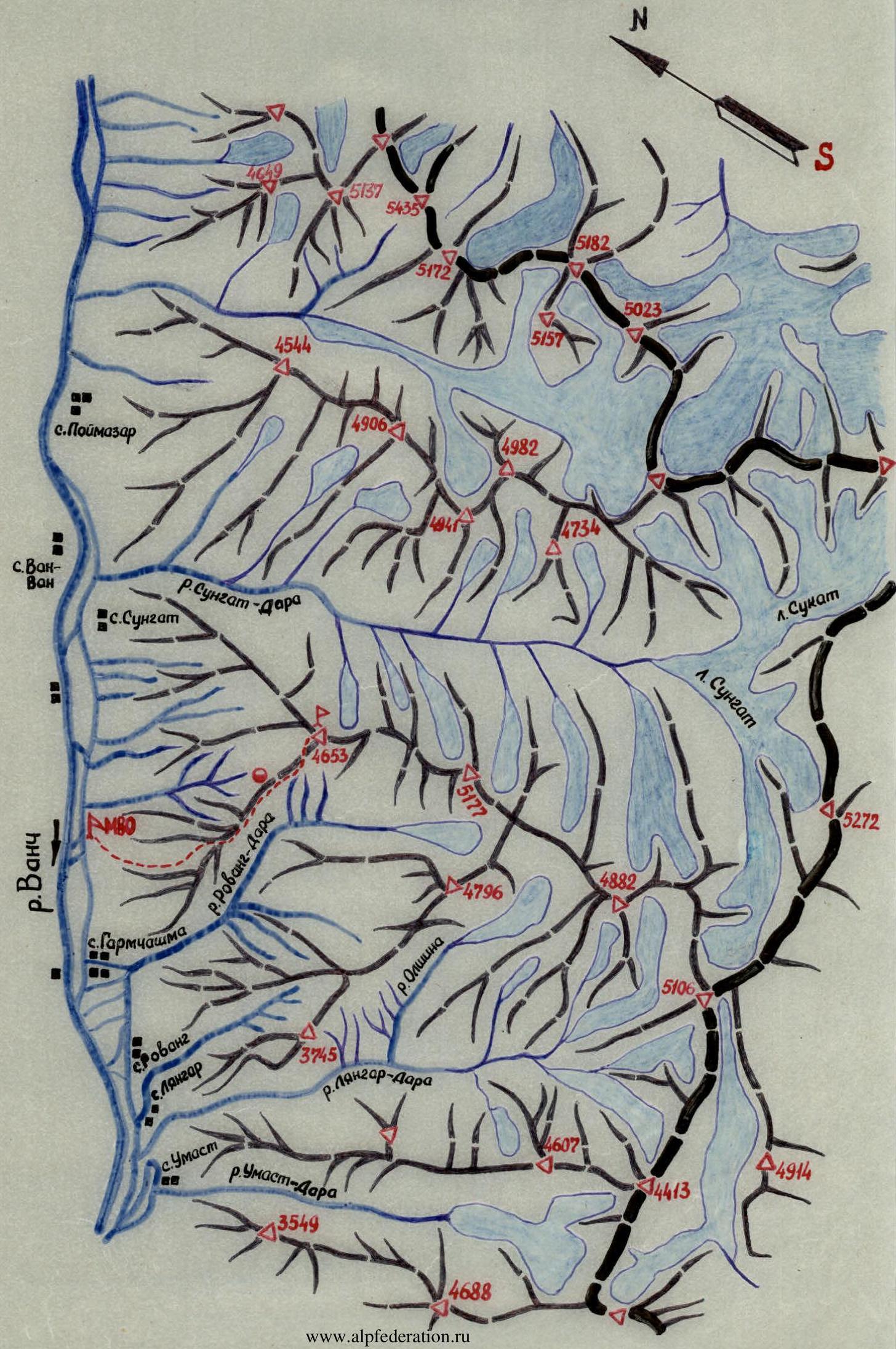
Diagram of the ascent route profile
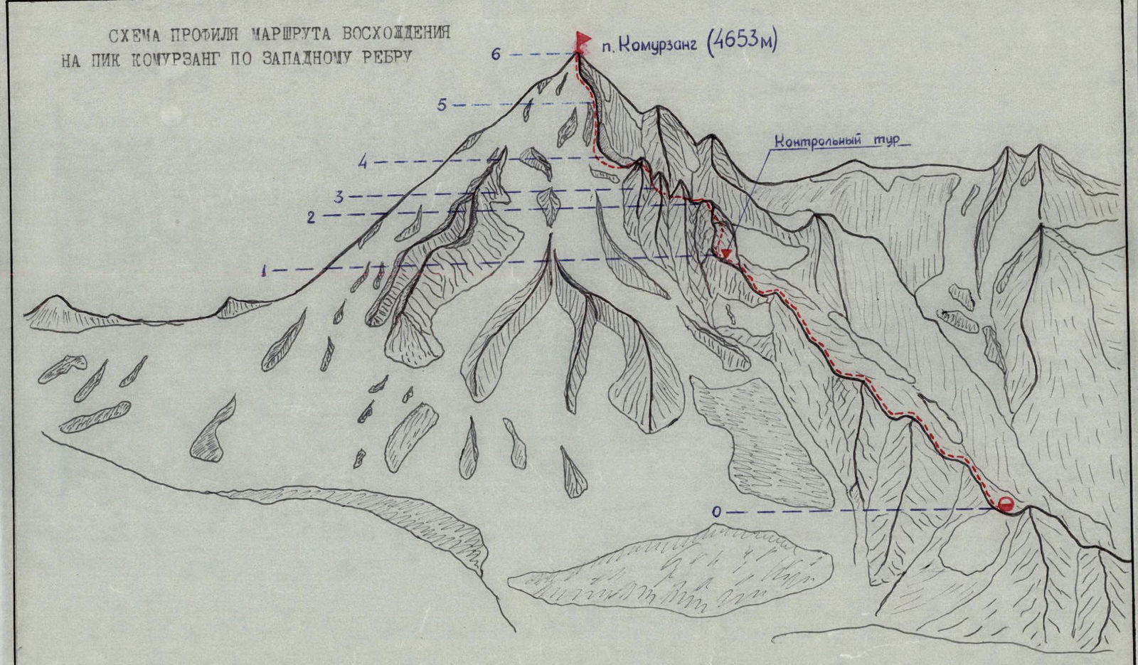
| Date | Designation | Average slope, in degrees | Length, m | Terrain character | Difficulty | Condition | Weather conditions | Rock | Ice | Bolted |
|---|---|---|---|---|---|---|---|---|---|---|
| July 12, 1979 | R0–R1 | 30 | 900 | ridge | 2 | damaged | good | – | – | – |
| R1–R2 | 70 | 60 | wall | 4 | rockfall hazard | "—" | 5 | – | – | |
| R2–R3 | 45 | 120 | "—" | 3 | monolithic | "—" | – | – | – | |
| R3–R4 | 35 | 250 | ledge, ridge | 3 | damaged | "—" | 2 | – | – | |
| R4–R5 | 45 | 120 | couloir | 4 | hard snow | "—" | – | – | – | |
| R5–R6 | 45 | 240 | ridge | 3 | damaged | "—" | 1 | – | – |
Notes
- The route was completed by a group from the Moscow Military District's mountaineering training camp. The group's release was supervised by the camp's head, first-released Master of Sports of International Class Demchenko A.S., and the head of the rescue team, senior instructor Nikolaev V.Ya.
- The route was repeated by a group from Tomsk on July 18, 1979, and subsequently by several groups during the Armed Forces championship training camp in July 1979.
- The ascent was reviewed at the Moscow Military District's base camp. The leadership and ascent were recognized (protocol of ascent review dated July 14, 1979).