-
Category of ascent
-
Area of ascent, ridge
-
Peak, its height, ascent route
-
Proposed category of difficulty
-
Route characteristics: height difference, average steepness, length
-
Pitons hammered for belay:
rock ice
-
Number of walking hours
-
Number of overnight stays and their characteristics
-
Surname, I.O. of the leader, participants and their qualification
-
Team coach
-
Date of departure and return
- High-altitude and technical.
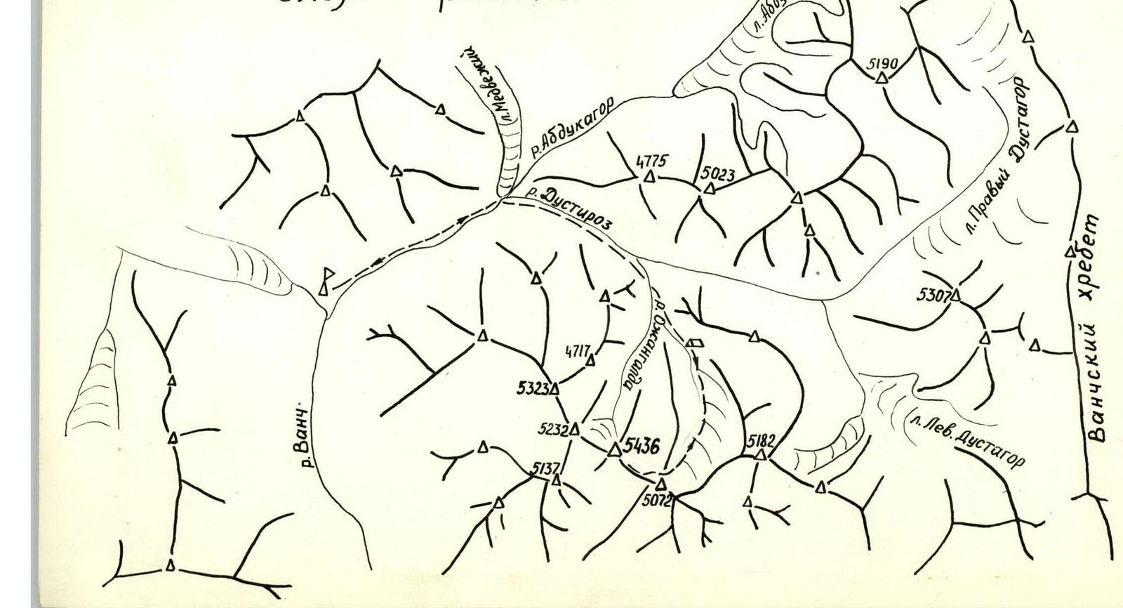
- Western Pamir, western spur of the Vanch Range.
- p. Vanchek, 5436 m, via the southern ridge.
- 5A cat. diff.
- 1585 m
- 40°
- 520 m
- 46 pcs.
- 13 pcs.
- 22 hours
- 2 bivouacs with lying down.
- Tunik A.L. Master of Sports, senior instructor, leader.
- Polin A.G. 1st sports category, participant
- Goldebaev V.I. 1st sports category, participant
- Beilin Yu.I. 1st sports category, participant
- Subbotin V.N. 1st sports category, participant
- Yushin Yu.I. Master of Sports, senior instructor, participant
- Master of Sports of the USSR, senior instructor Tunik A.L.
- July 16–19, 1976 (including approach)
Area Diagram
| Date | Section No.  | Section length, m | Average steepness | Altitude gain, m | Terrain characteristics | Rock  | Ice | Difficulty  |  | Condition |
|---|---|---|---|---|---|---|---|---|---|---|
| July 17 | R0–R1 | 650 | 40° | 400 | Snowy couloir | - | - | 1–2 | firn | |
| R1–R2 | 60 | 40° | 40 | Rocky ridge | - | - | 2 | destroyed | ||
| R2–R3 | 140 | 45° | 100 | Traverse of a snow-ice slope with exit to rocky islands | 2 | 1 | 3 | avalanche danger! | ||
| R3–R4 | 110 | 50° | 85 | Ice slope | - | 6 | 3–4 | thin layer of snow on ice | ||
| R4–R5 | 700 | 25° | 350 | Snowy ridge | - | - | 1–2 | deep loose snow | ||
| July 18 | R5–R6 | 110 | 0 | -20 | Descent into a hollow and passage along a corniche ridge of a snowy saddle | - | - | 3–4 | narrow ridge, cornices on the right | |
| R6–R7 | 100 | 45° | 20 | Traverse of a snow-ice slope | - | 4 | 3–4 | |||
| R7–R8 | 200 | 65° | 180 | Rocky buttress | 6 | - | 4–5 | rockfall danger! destroyed rocks | ||
| R8–R9 | 100 | 65° | 20 | Traverse left-upwards | 3 | - | 4–5 | «—» | ||
| R9–R10 | 160 | 75° | 160 | Wall of the summit tower | 14 | - | 5 | «—» | ||
| R10–R11 | 200 | 65–70° | 50 | Traverse to the right under the ridge | 12 | - | 5 | ridge heavily destroyed | ||
| R11–R12 | 80 | 80° | 80 | Pre-summit ascent | 9 | - | 5 | less rockfall danger | ||
| R12–R13 | 400 | 15° | 100 | Pre-summit ridge | - | - | 3 | destroyed | ||
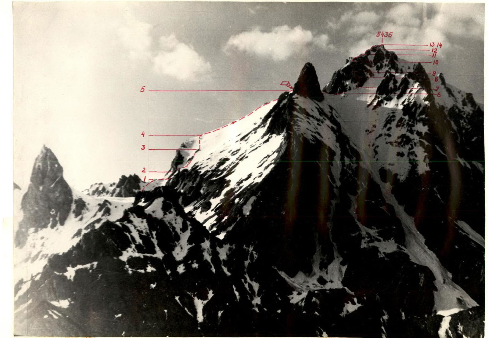
| R13–R14 | 70 | 60 | 20 | Traverse of an ice slope and exit to the summit | - | 2 | 3–4 | snowy corniche on the ridge. Dangerous! |
Brief description of the first ascent to p. Vanchek
Day 1 — July 16, 1953
From the "Vysochnik" alpine camp along the Dusti-Roz river valley to the summer pastures, then along the right bank of the Ojangalda river to the canyon. Opposite the abandoned mines — ascent to the moraine and glacier under the Eastern ridge of p. 5182. Overnight stay on the moraine.
From the "Vysochnik" alpine camp to the overnight stay 10–12 hours. In mid-July, fording the Abdukagor and Ojangalda rivers is difficult due to the abundance of water.
Day 2 — July 17, 1953
From the overnight stay on the glacier moraine — rightwards upwards under the western slope of p. 5072, bypassing the gentle western ridge extending from p. 5072. Crossing this ridge at the leftmost saddle. The saddle and ascent to it are snowy. From the overnight stay to the saddle — 4–5 hours.
From the saddle, a snowy descent of about 100 m to the glacier under p. Vanchek. Bergschrund! Approach along the glacier to the leftmost snowy couloir. Ascent via the couloir (section R0–R1) (firn) with steepness from 30° to 45–55° in the upper part. Exit to the southern ridge of p. Vanchek — 3 hours from the saddle.
A convenient place for a bivouac. A small lake. Further along the large-block destroyed rocky ridge (section R1–R2) under the wall. From it, traverse to the right into a snow-ice couloir (avalanche danger!) and then upwards along a snow-ice slope with rock outcrops (section R2–R3). Snow on the ice is less than 10 cm. Further along a snow-ice slope with a thin (2–5 cm) layer of snow in the lower part of the slope, exit again to the southern ridge of Vanchek (section R3–R4). The ridge (section R4–R5) is gentle, snowy with insignificant outcrops of simple destroyed rocks. Snow is местами loose and deep. To the left are steep rocky walls and cornices. To the right is a gentle (30°) slope that quickly becomes steep.
The ridge leads to the shoulder of a huge rocky gendarme, clearly visible from all southern approaches to Vanchek. On the shoulder is a convenient place for a bivouac. From the lake 5–6 hours. Here at 19:00, we set up for the night.
Day 3 — August 18, 1953
From the gendarme's shoulder, descent along a steep scree slope 10–15 m to the snowy ridge of the saddle (section R5–R6). The ridge is narrow, with large cornices on the right. The left slope of the ridge is 50–60° steep. The ridge abuts a snow-ice slope, above which the summit tower of Vanchek rises. The lower part of the tower — walls with individual steep, not obvious buttresses. The entire summit tower is extremely rockfall-prone. Rocks are brittle, layered. On the monolithic base of the rocks, there is everywhere a layer of destroyed, unstable rock. A large number of "live" stones.
Due to the high rockfall danger of further ascent, section R7–R8 is overcome by parallel rope teams along adjacent, not obvious buttresses, which merge with each other at the end of the section and abut the wall. Climbing is difficult. Piton belay is hampered and unreliable due to the brittle, upper crust of the rocks.
After 3–4 ropes, the buttresses merge with the wall. Traverse left-upwards along similarly destroyed rocks for 2–3 ropes (section R8–R9). Climbing is difficult, местами of moderate difficulty. Rockfall danger and belay conditions are similar to the previous section.
Exit to the ridge under the wall of the summit tower. The wall (section R9–R10) is overcome head-on. Climbing is difficult. The upper layer of rock is destroyed. Many "live" unstable large blocks and flakes. After overcoming this wall, one can move along the summit ridge, but it is more convenient to go 2–5 m under the ridge to the right, as the ridge is heavily destroyed and many large blocks overhang to the left under the western slopes of the ridge (section R10–R11). The ridge abuts a pre-summit wall less rockfall-prone than all previous ones. The wall (section R11–R12) is overcome head-on, then along a gently rising pre-summit southern ridge (section R12–R13) with rocks of moderate difficulty, местами snow-covered with individual cornices.
Before the very summit, on the ridge is a large snowy corniche to the right, which is bypassed by a traverse to the left along an ice-snow slope. On the summit are cornices to the north. A cairn is built in the crevices on the eastern slope of the summit, 2–3 meters below the summit. Descent is via the ascent route. From the summit to the overnight stay on the gendarme — about 4 hours.
Day 4 — July 19, 1953
Further descent to the base of the couloir takes 2–3 hours, ascent to the saddle and return to the first overnight stay location — 3–4 hours. In case of favorable conditions for fording the Ojangalda and Abdukagor rivers, it is possible to return to the camp on the same day.
Weather during the first ascent:
- 1, 2, 3 days (July 16–18): clear, calm.
- 4th day (July 19): cloudy.
Assessment of the route difficulty
The main technical difficulties on the route are concentrated in the upper part at an altitude of about 5000 m.
This is a pre-summit rocky tower with an overall steepness of about 65° and sections of difficult climbing up to 100 m long. Throughout the ascent to the tower, the rocks are heavily destroyed, layered, and brittle. Piton belay is hampered and unreliable. Ridge rocky sections are composed of large unstable blocks and layered flakes. Climbing and belaying require extreme caution.
In the middle part of the route, there are ice sections of moderate difficulty, which in mid-July are free from snow cover (southern and eastern exposure).
Compared to classified routes in this area, it is somewhat more difficult than the routes to Peak Tbilisi (5933 m) — 5A cat. diff. and the traverse of peaks 4775–5023 m — 5A cat. diff.
Compared to classical routes, it is overall more difficult than the traverse of Domбай and approximately equal to the route to Western Mizhirgi via the Sella pass according to the 5A cat. diff.
The group of first ascenders proposes to classify the route as 5A cat. diff.