
RUSSIAN MOUNTAINEERING FEDERATION 58 Б/4. 487 and 12 Without KSp protocol Entered on 01.04.80 Order of the Committee dated 06.11.80, 5B exists Appendix 1
dated 08.01.80 Championship of SA and Navy in mountaineering – ROCK CLIMBING CLASS – PAMIR, VANCH RANGE
Report
of the UralVO SCA team on the ascent to peak ARDABAG (Central) via the NW wall (first ascent)
Team leader: EVSYUKOV G.K., CMS Members:
- ZADVORYEV Y.V., CMS
- LENSKY S.V., 1st sports category
- POVOLOTSKY V.Y., CMS
Team coach: MIKHAILOV A.A., MS
1979
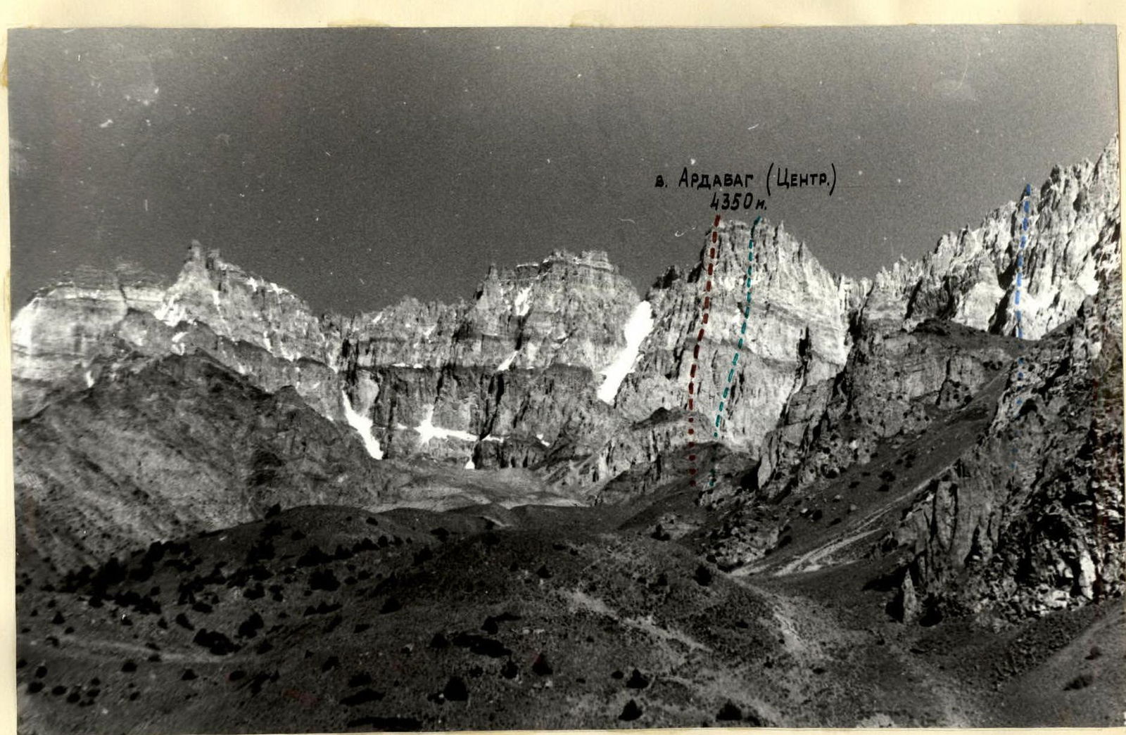 Peak ARDABAG (Central) 4350 m.
Photo 1. General view of the section of the C wall of the Ardabag massif
(routes of the teams of the SA and Navy Championship in mountaineering 1979)
Peak ARDABAG (Central) 4350 m.
Photo 1. General view of the section of the C wall of the Ardabag massif
(routes of the teams of the SA and Navy Championship in mountaineering 1979)
- LenVO
- UralVO
- PrikVO
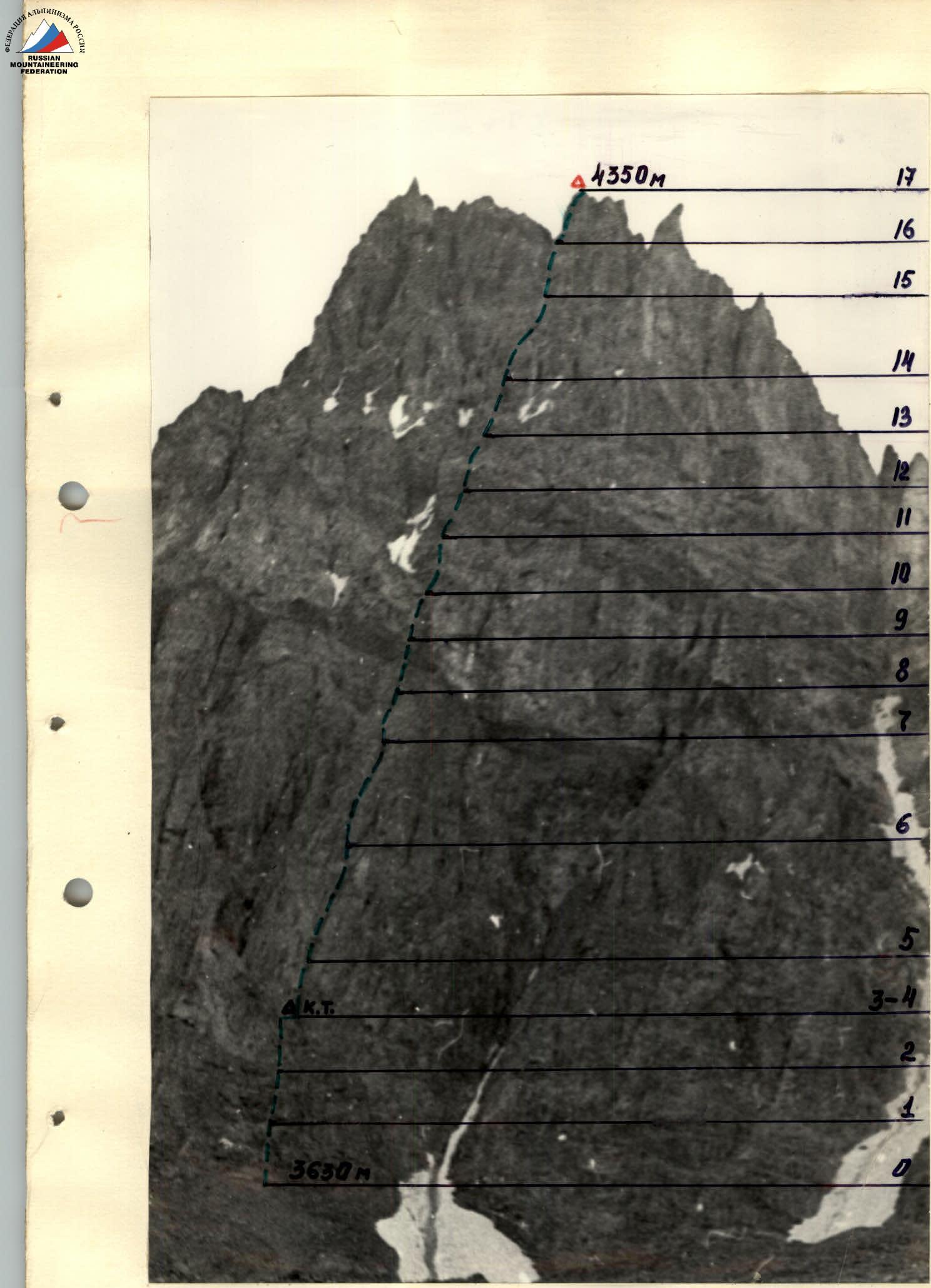 Profile of the ascent route via the NW wall of peak Ardabag (Central)
Summit: 4350 m (R17). Lower point: 3630 m (R0). Control point: K.T. (on R3–R4).
Section numbers: R0, R1, R2, R3–R4, R5, R6, R7, R8, R9, R10, R11, R12, R13, R14, R15, R16, R17.
Profile of the ascent route via the NW wall of peak Ardabag (Central)
Summit: 4350 m (R17). Lower point: 3630 m (R0). Control point: K.T. (on R3–R4).
Section numbers: R0, R1, R2, R3–R4, R5, R6, R7, R8, R9, R10, R11, R12, R13, R14, R15, R16, R17.
Map of the area
SA and Navy Championship in mountaineering 1979
(Vanch Range)
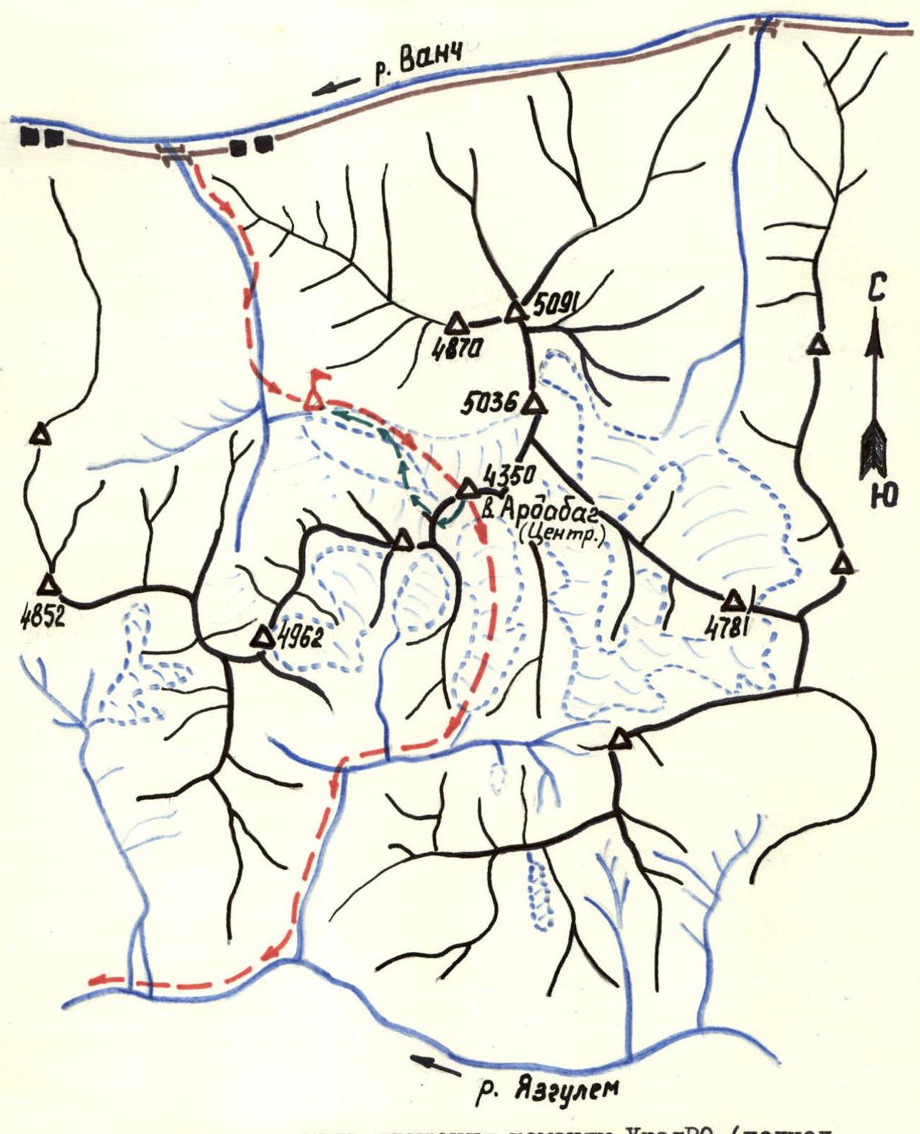
- – – – path of the UralVO team (approach and descent from the summit);
- – – – recommended path of return to the base camp;
- Δ – base camp The map shows the Vanch and Yazglem rivers, directions N, E, S (North, East, South), as well as peaks: 4852, 4962, 4870, 5036, 5091, peak Ardabag (Central) 4350, 4781.
Description of the approach to the route
The location of the 1979 SA and Navy Championship was chosen to be the Ardabag massif located in the Vanch Range. The route of the UralVO team was laid via the NW wall of its Central peak (4350 m).
The path to the route (see the map of the ascent area) lies through one of the gorges formed by the meridional spurs of the Vanch Range, descending north to the Vanch River. This gorge is rarely visited, and its slopes are used as pastures for livestock in the summer (in the upper reaches - a "kosh"). It is convenient to reach the beginning of the gorge by car, following the asphalt road from the district center of Vanch to the village of Ardabag.
The trail starts 300 m from the village at the car bridge and goes to the right (orographically) along the river through a stony slope of the gorge, sometimes hard and steep.
After 1 hour of walking, the trail, bypassing the pressure ridges, crosses to the opposite side of the river (there may be a small bridge) and returns back after 200 m (ford). It is recommended to pass this section in the first half of the day.
Further, there is a steep climb to the moraine, and the trail leads to a large clearing to a summer "kosh". To the south, the entire circus of the Ardabag massif is visible (photo 1), and sections of the ascent routes of the Championship can be distinguished. There is a convenient place for a base camp with water. From the motorway - 2.5-3.0 hours.
From the base camp, follow the trails to climb to the green hills, keeping to their right slopes, and from there, overcoming a series of moraine shafts of the circus (steeply), approach the Central peak of the Ardabag massif, guided by a characteristic snow "tie" at the foot of the peak (250 m to the left - the start of the route). The approach from the base camp to the route takes 3 hours.
The beginning of the route - the base of the steep inner corner - is accessed via scree shelves, with a gentle section of "ram's foreheads" in the lower part.
The descent from the summit was undertaken by the UralVO team on the opposite side of the route to the massif to its South circus, and then down to the right to the Yazglem River gorge and further down the river, bypassing several kishlaks, to the motorway on the Pyanj River. This path is quite simple and safe but lengthy, as it requires up to one and a half days to return to Vanch (with an overnight stay in a kishlak).
In this regard, another path is recommended from the summit. It also involves descending to the south to the upper stage of the moraine of the South circus of the Ardabag massif, then traversing to the right to the place of the greatest lowering in the massif with a climb back to the ridge and subsequent descent along the northern slopes of the massif and a small counterfort to the North circus and further to the base camp. Such a path is more complicated, as it requires the use of piton insurance and vertical ropes in many of its sections, but it is shorter and provides a return directly to the starting point - the base camp.
Table of main characteristics of the route
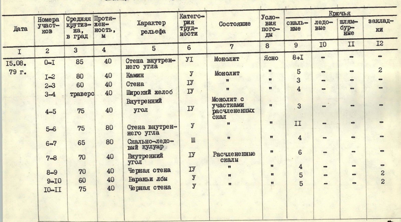
(continuation of the table)
| Date | Section | Steepness, ° | Length, m | Character of relief | Category of difficulty of the section | State | Weather conditions | Rock pitons | Ice pitons | Bolt pitons | Nuts |
|---|---|---|---|---|---|---|---|---|---|---|---|
| 15.08.79 г. | R0–R1 | 85 | 40 | Wall of the inner corner | 6 | Monolith | Clear | 8+1 | - | - | - |
| R1–R2 | 80 | 40 | Chimney | 5 | Monolith | " | 5 | - | - | 2 | |
| R2–R3 | 60 | 40 | Wall | 4 | Monolith | " | 3 | - | - | - | |
| R3–R4 | 40 (traverse) | 40 | Wide groove | 4 | Monolith | " | 4 | - | - | - | |
| R4–R5 | 75 | 40 | Inner corner | 4 | Monolith with sections of fractured rocks | " | 3 | - | - | - | |
| R5–R6 | 75 | 80 | Wall of the inner corner | 5 | " | " | 11 | - | - | - | |
| R6–R7 | 65 | 80 | Rock-ice couloir | 3 | " | " | 4 | - | - | - | |
| R7–R8 | 70 | 40 | Inner corner | 4 | Fractured rocks | " | 6 | - | - | - | |
| R8–R9 | 70 | 40 | Black wall | 4 | " | " | 4 | - | - | 1 | |
| R9–R10 | 60 | 40 | Ram's foreheads | 5 | " | " | 5 | - | - | 2 | |
| R10–R11 | 75 | 40 | Black wall | 5 | " | " | 5 | - | - | 2 | |
| 15.08.79 г. | R11–R12 | 75 | 40 | Inner corner | 5 | Monolith with sections of fractured wet rocks | Clear | 6+1 | - | - | - |
| R12–R13 | 70 | 40 | Chimney with a plug | 5 | " | " | 6 | - | - | - | |
| R13–R14 | 65 | 40 | Rock rib | 4 | Monolith with sections of rock fracturing | " | 4 | - | - | - | |
| R14–R15 | 70 | 80 | Groove | 4 | " | " | 7 | - | - | - | |
| R15–R16 | 70 | 40 | Wall | 5 | Fractured rocks | " | 4+1 | - | - | 3 | |
| R16–R17 | 70 | 40 | Rock tower | 5 | " | " | 4 | - | - | 3 |
Time of exit to the route - 8:30. Time of reaching the summit - 17:30. Total time of walking hours - 9 hours. (Overnight stay during descent from the summit - on the moraine of the South circus of the Ardabag massif)
Team leader
 G.K. Evsyukov
Description of the route passage
(explanation to the table of main characteristics of the route)
August 15, 1979
At 5:00, we started the approach and by 8:00, we approached the route. At 8:30, we began the passage of the route in pairs:
- Evsyukov - Lensky
- Povolotsky - Zadvoriev
The first two ropes represent a steep inner corner, turning into a wide chimney at the top - difficult climbing.
This key section of the lower rock belt of the wall was passed by the first (Evsyukov) without a backpack, mostly free climbing (1 ITO), with thorough piton insurance on a double rope (see photo 4). The other participants climbed with backpacks on the rope (on jumar) and with top insurance (see photo 5). This scheme of passing the most difficult sections of the wall was used further along the entire route.
On the next section of the wall after the chimney, the Povolotsky - Zadvoriev pair moved forward, and both pairs moved independently towards the large inner corner dissecting the wall, traversing to the right across a steep, stone-hazardous couloir - a groove. Before its beginning, they made a control cairn and left a note in it - 10:30.
Further, the path passed through a steep inner corner - lengthy and stone-hazardous due to the presence of many "live stones", which required increased caution during movement. They moved with alternate insurance and organization of ropes, periodically changing the lead. As they climbed, the climbing became more complicated, and soon, in search of reliable cracks, they had to move left to the wall with sections of difficult and steep rocks.
At the end of the wall, there was a depression filled with snow and ice - the beginning of a narrow rock-ice couloir.
Moving alternately along the left edge of the rocks, they passed the couloir (see photo 6) and through a peculiar "stone box" (live stones!) reached a small ledge in front of the black wall. Here, it is possible to organize an overnight stay; there is water nearby.
Directly in front of them was the "black belt" - an extended section of strongly fractured rocks and "ram's foreheads". From here, the West ridge of the massif is clearly visible, where the movement of other teams of the Championship is noticeable, to the left and below us is the route of the "duo" LenVO.
After a short snack and a radio session with observers (at 14:00), they moved on to the "black belt", the passage of which required significant effort and accuracy in climbing and selection of means for effective insurance, due to the continuous alternation of smoothed and heavily destroyed sections. Extended pitons and slings were used. The most serious obstacle was the inner corner adjacent to the "black belt", flooded with water and ice, to overcome which the first (Evsyukov) had to use a ladder.
The chimney followed the inner corner, with ice trickles inside and a firmly seated plug in the middle. It was passed by free climbing with the organization of ropes. Behind the chimney, the wall becomes gentler, forming an implicitly expressed rib, leading then to a long and steep groove, the right part of which overhangs in places, suggesting movement along the left part. When organizing ropes, their end points were taken several meters to the left due to the danger of dropping "live" stones.
The key section when passing the upper rock belt of the wall was the exit to the ridge of the massif. Characteristics of the section:
- Steep and heavily destroyed rocks
- Overhanging sections in the upper part
- Climbing is tense
- Pitons are difficult to hammer
At 17:00, they reached the ridge, and at 17:30, having overcome a steep rock tower, the entire team gathered at the summit.
Thus, in 9 hours of ascent, 17 ropes of the route (720 m in height) were passed, 92 rock pitons were hammered, and 12 slings were used.
After considering possible descent options, having received a consultation from the judges' panel and other teams on the routes via radio, the team decided to change the previously planned descent path (with a traverse along the West ridge), planning a simpler option with a descent to the South circus of the massif. It is recommended to traverse the moraine of the circus in a westerly direction, crossing over to the North circus of the massif through a lowering in the ridge.
Characteristics of the route and recommendations for its passage
The route passed by the team is logical and leads directly to the Central peak of the NW wall of the Ardabag massif. The entire route is purely rock with an alternation of:
- inner corners,
- chimneys,
- walls,
- ribs.
The route is safe; the team must have good rock climbing training to pass it. In August, there is very little snow on the route, and water is found only in the middle and upper parts of the wall.
In the middle part of the route, there are ledges suitable for overnight stays.
The team got great satisfaction from the passed route and rated it as 5B category of difficulty. According to the participants of the ascent, it can be compared with the following routes: In the Fann Mountains:
- with the route to peak Chimtarga via the 10th rib, 5B category of difficulty;
- with the route to peak Aurondag via the Central NW wall, 5B category of difficulty;
- with the route to peak Rudaki via the right counterfort - 5B category of difficulty. In the Matcha area:
- with the route to peak - Warsaw, 5B category of difficulty. In the Caucasus:
- with the first ascent of the team of the Armed Forces on peak Ak-Kaya 5B category of difficulty within the framework of the 30th USSR Championship in the rock climbing class in 1979 (here the upper and lower belts are comparable).
The passage of the route can be recommended to groups with significant experience in rock climbing.
It is advisable to build a tactical plan for the ascent, providing for one overnight stay in the middle part of the wall, as further, up to the exit to the ridge, there are no more places convenient for a bivouac.
For the convenience of returning to the base camp (see the map of the area), it is recommended:
- Descend by a simple path from the summit to the south;
- Then cross over through the lowering in the West ridge of the Ardabag massif;
- Return back to its North circus.
In conditions of bad weather, as well as with heavy snow cover on the wall (at the beginning and end of the season), it is not recommended to start the route.
Photo 4. Passage of section R0–R1