 Peak 5826 meters.
NORTH-WESTERN PAMIR. MALY TANIMAS VALLEY. FIRST ASCENT.
1967.
Peak 5826 meters.
NORTH-WESTERN PAMIR. MALY TANIMAS VALLEY. FIRST ASCENT.
1967.
Sports group of the Odessa DSO "Avangard".
Ascent leader V. Nelupov.
 Odessa. 1969.
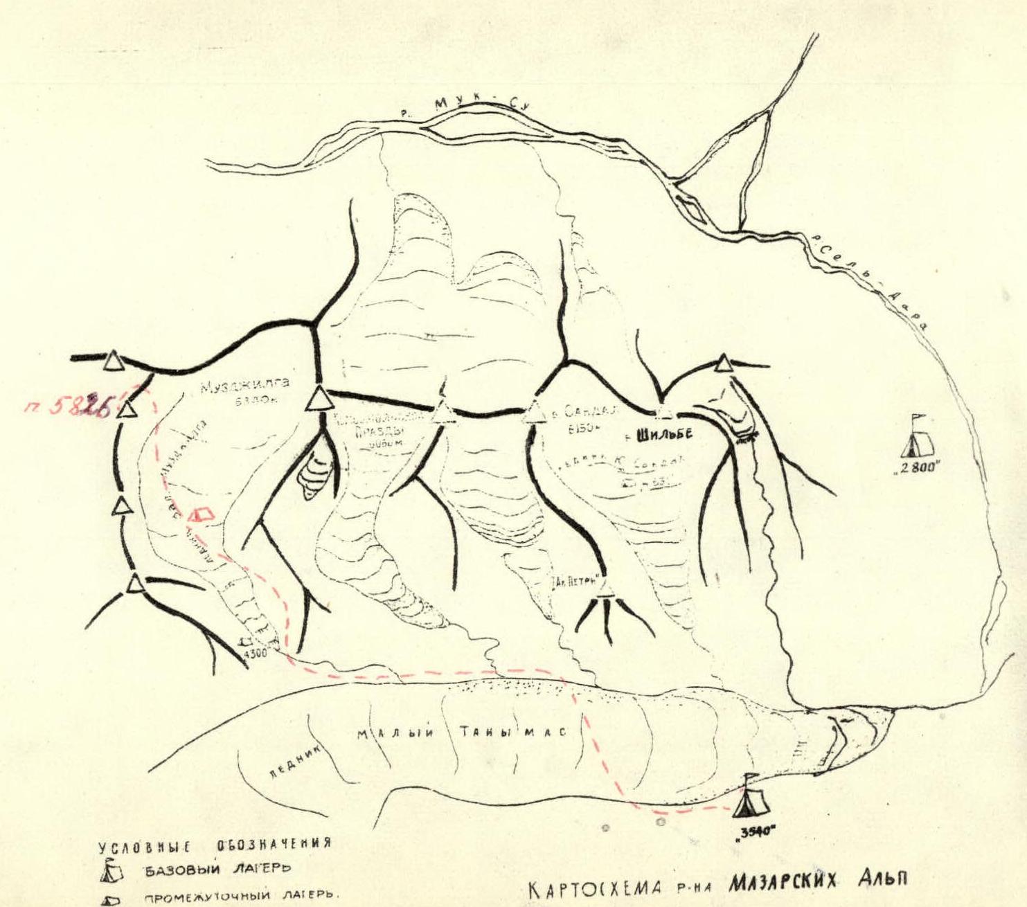
Peak "5826 m" is located in one of the ridges formed by the peaks:
- Muzzhilga (6340 m),
- Komsomolskaya Pravda (6050 m),
- Sandal (6150 m),
- Shilbe (6120 m),
in the so-called Mazarskie Alpy area, which is a spur of the powerful Akademii Nauk range.
To the north-east and south-west, the area is separated from the parallel-lying Maly Tanymas ridge by the glacier of the same name and the river flowing from it, which flows into the Sel-Dara river in the immediate vicinity of the Fedchenko glacier tongue.
The Mazarskie Alpy are separated from the Zaalaysky ridge by the wide Muksou river overflow to the south-west.
A characteristic feature of the area is the short length of the glaciers, which are quite steep in the upper part and gentle in the middle and lower parts, with a small number of crevasses. The surface of the glaciers in the lower part is covered with a shell of destroyed rocks.
Climbing conditions
The ascent route to peak "5826 m" is ridge-based, mainly snow-ice with rock outcrops on the pre-summit ridge; the rock texture is layered and heavily destroyed.
Due to the fact that huge cornices overhang on the south side of the ridge, the route runs along the north face of the ridge.
The ascent took place in July. Weather conditions throughout the month were excellent - warm during the day, -10°C at night.
During the day, snow on steep sections flows, there is a real danger of avalanches.
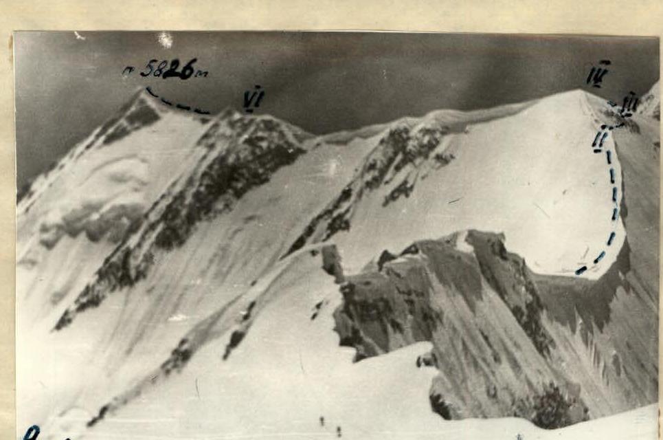
View of p. 5826 m from the saddle between p. Muzzhilga and p. 5881 m. The photo was taken during a reconnaissance trip.
 Section R4–R5
Ascent description
Day I
The ascent was carried out from the upper base camp of the expedition, located in the pocket of the lateral moraine on the right orographic side of the Maly Tanymas glacier (height 3500 m); to the right of the southern edge of p. Sandal.
From the base camp, the direction of movement is up the trail to the couloir in the moraine in front of the river flowing from the Maly Tanymas ridge. Descent to the Maly Tanymas glacier and crossing it in the direction of the side gorge - to the left of the southern edge of p. Sandal.
Further, movement along the loose slope of the foot of p. Sandal along the river flowing from the Zapadny Muzzhilga glacier.
There are places for organizing overnight stays on the right lateral moraine of the glacier.
The travel time from the base camp to the overnight stay is 6 hours. On the same day, a reconnaissance was carried out to determine the possible ascent route to the summit.
Day II
From the overnight stay, movement along the glacier in the direction of a clearly defined gendarme on the saddle along the glacier. Travel time - 2 hours. (Section R0–R1)
From the flat upper snow plateau of the glacier, bypassing crevasses, movement upwards in the direction of the gendarme on the saddle along a steep snow slope (40°, 400 m). Movement in rope teams is simultaneous. Exit to the saddle to the left of the gendarme. Travel time - 1.5 hours. (Section R1–R2)
From the saddle upwards along the left side of the edge along a steep slope (40°, 200 m), below the line of cornice break-off hanging on the right side, to the place where the cornices fork, overhanging on the left side. Exit to the ridge at the place where the cornices fork. Movement in rope teams is alternate. Belay through an ice axe. Travel time - 1.4 hours. (Section R2–R3)
From the ridge, transition to the right (in the direction of travel) side along a steep ice slope (60°, 80 m) by traversing in the direction of rock outcrops on the slope. Alternate movement on ice steps. Piton belay. Travel time - 0.6 hours. (Section R3–R4)
From the rocks upwards along a steep snow slope.
Sections R4–R5–R6–R7–R8
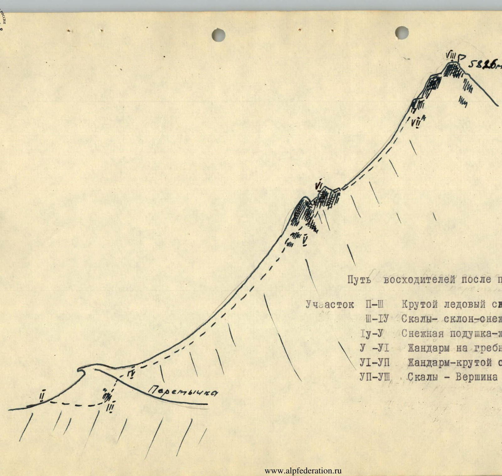
The path of the climbers after the saddle: Section R2–R3: Steep ice slope - rocks. Section R3–R4: Rocks - slope - snow cushion. Section R4–R5: Snow cushion - gendarmes. Section R5–R6: Gendarme on the ridge. Section R6–R7: Gendarme - steep snow slope - rocks. Section R7–R8: Rocks - Summit.
To the snow cushion of the saddle between peaks "5881 m" and "5400 m". Travel time - 0.5 hours. (Section R4–R5) From the saddle along the right (not visible in the photograph) side of the ridge, below the supposed line of snow-ice cornice break-off (cornices hang on the left side of the ridge), along a steep snow slope (40°, 600 m) - movement upwards in the direction of the gendarme on the ridge. Simultaneous movement. Travel time - 2.5 hours. (Section R5–R6) The first gendarme is bypassed on the right along the snow. The exit to the second gendarme is carried out along the rocks on the left upwards along the wall (70°, 20 m). Rocks are above average difficulty, heavily destroyed, with many loose rocks. Piton belay and through ledges. Time to overcome the section - 0.5 hours. (Section R6–R7) From the gendarme, descent to the right side of the ridge, then movement along a steep snow slope below the ridge in the direction of rock outcrops in front of the summit (45°, 200 m). Alternate movement, belay through an ice axe. Travel time - 1 hour. (Section R7–R8) Along steep, destroyed rocks, overcoming the rock wall, exit to the summit (55–60°, 40 m).
Descent from the summit and return to the overnight stay along the ascent route.
Total ascent time - 14 hours.
Conclusion
The route passed is a first ascent. The group believes that it corresponds to a category 3B route.
We made this conclusion based on a comparison of the route taken with the well-known Caucasian routes: Bzheduk - 3B category, Andyrchi - 3B category, as well as the routes taken by the group to the peaks of the South-Western Pamir - p. TGU (6148 m) - 4A category, p. Danilyaitisa - 3B category.
In terms of complexity, the route to "p. 5881 m" is not inferior to them, and taking into account the nature of the first ascent and the associated difficulties, make it a category 4B route for first ascenders.
Expedition leader: E. Sviridenko Coach-observer: E. Levitsky Ascent leader: V. Nelupov
Group composition
- Nelupov V. A. - 1st sports category, leader
- Stetsenko N. N. - 1st sports category, participant
- Cheskidov N. N. - 2nd sports category, participant
- Vlasenko A. V. - 2nd sports category, participant
- Orobey I. N. - 2nd sports category, participant
- Mozeson A. F. - 2nd sports category, participant
- Levitsky E. A. - Master of Sports, coach-observer