N512 4.57
AKADEMIYA NAUK RANGE. PEAK 5429 M VIA THE EAST RIDGE (approximately category 4A) Team of the Ukrainian Republican Council of the SDSO "BUREVESTNIK"
PAMIR 1981
Map of the ascent area
to p. 5429.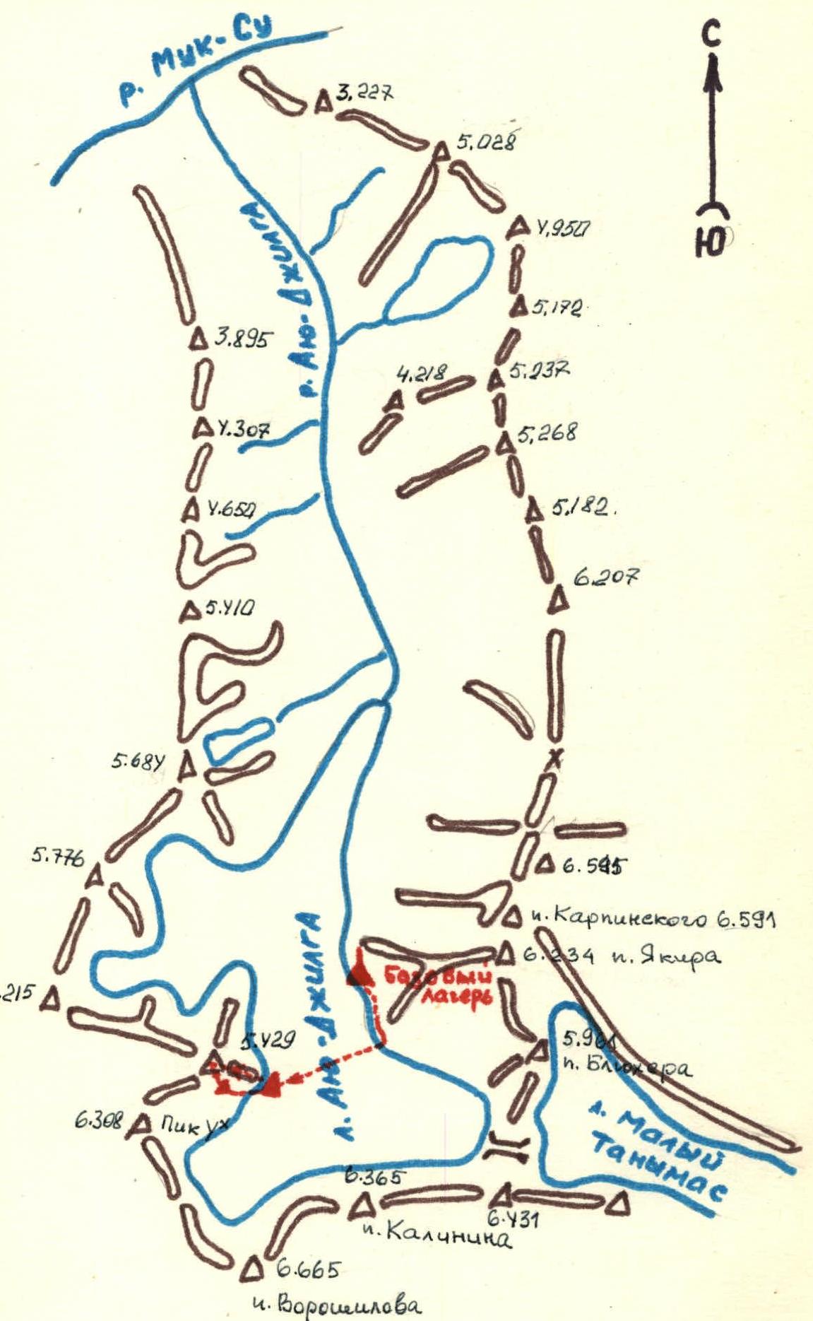
M: 1 cm – 1 km
Description of the approach to the route
Peak 5429 m is located in a spur of the Peter the First Range, in the cirque of the southern part of the Ayu-Jilga glacier, between peak 4×6308 m on the left and p. 6215 m on the right.
The length of the Ayu-Jilga glacier is about 9 km. It stretches from south to north and occupies an area of about 20 sq. km. The Ayu-Jilga river, flowing out of the glacier to the north, flows into the Muksu river, to which there are about 20 km along the Ayu-Jilga gorge. Ayu-Jilga is a rather full-flowing river, and it is not recommended to ford it; it is better to cross it on the glacier.
Our expedition was delivered by helicopter to a site on the moraine, located at the level of the northern edge of the glacier. The approach from the Muksu gorge is possible along the right (in the direction of travel) bank of the Ayu-Jilga river. This path was used by participants of the Dnepropetrovsk expedition in 1975. After ascending to the Ayu-Jilga glacier, it must be crossed in the lower part and moved to the left-bank (in the direction of travel) moraine. At an hour's walk up the moraine is the site of our base camp - the expedition of the Ukrainian "Burevestnik" in 1981.
About 1-1.5 hours of walking up the left-bank moraine, you need to cross the glacier to the right and approach a wide talus cone under the eastern slopes of p. 5429, which closes from below a long snowy couloir emerging on the snowy dome of the peak.
A place for a bivouac - on the moraine, in the area of the talus cone. It is not recommended to set up a tent closer to the wall due to powerful and prolonged rockfalls from the eastern slopes of p. 5429 and the couloir above the cone.
The tactical plan of the ascent was determined by the results of observing the route during the day through a 40x spyglass. The places and times of rockfalls and avalanches were observed, and the time of sunlight on the snowy slopes was determined. Taking into account the rapid thawing of snow in the sun and the avalanches and rockfalls that began soon after, the following schedule was adopted:
| Date | Time | Event |
|---|---|---|
| 18/07–1981 | 6:00 | Departure on the route. |
| 8:00 | Approach the beginning of the inclined snow plateau with a gully. | |
| 10:00 | Pass the snow plateau with a gully and approach the exit to the ridge. | |
| 12:00 | Reach the shoulder of the ridge. Set up a tent. After the sun leaves the slope, trample the tracks. Overnight stay. | |
| 19/07–1981 | 6:30 | Departure. |
| 8:00 | Reach the firn slope with rocky outcrops. | |
| 9:00 | Reach the rocky belt. | |
| 9:30 | Reach the pre-summit ascent. | |
| 10:00 | Reach the snowy dome. | |
| 10:30 | Reach the summit. | |
| 12:00 | Descent to the overnight stay. | |
| 17:00 | Descent to the base camp. |
The route was followed almost without deviations from this schedule. It is worth noting that the assessment of various sections of the route, made during observation, was confirmed during the ascent.
Description of the ascent
July 17. We leave the base camp after lunch, at 16:30. We ascend the moraine of the Ayu-Jilga glacier. About an hour later, we approach the place where we need to cross the glacier and cross onto the ice. The glacier is covered with fine debris and torn along the edges. We bypass the crevices and reach a flat glacial plateau. At this point, the glacier is quite wide, and its crossing takes 45 minutes. We cross a wide ridge of talus and approach a wide talus cone - the beginning of the route. We look for a place for a tent. Two rockfalls that have come down are good confirmation that the tent needs to be set up further from the wall. We clear a site on a small moraine on the glacier, set up a tent. From here to the start of the route is a 20-minute walk.
July 19. Rise at 5:30. We have breakfast, get dressed, gather, tie up, and depart on the route.
The beginning of the route is hard, compacted talus, covered with small stones (section R0–R1).
We approach the mouth of the couloir (section R1–R2). We pass it as quickly as possible, alternately, and exit to the rocks (sections R2–R3 and R3–R4).
In the lower part - rocks of medium difficulty, plate-like; in the upper part - above medium difficulty, smoothed. We pass with piton protection, but, remembering the rockfall that passed here yesterday, we try to do it as quickly as possible.
After 30 minutes of energetic climbing, we exit to the snow. We ascend the left side of the snow plateau with a gully in the middle (section R4–R5). The sun has not yet reached these places, so the snow is hard and holds well.
At the end of the plateau, we approach the beginning of the ridge. We cross an implicit snow-ice couloir (section R5–R6) and exit to a snowy slope leading to the ridge.
This slope (section R6–R7) is quite steep, with deep, already thawing snow. The depth of the snow is 80 cm, and in some places more. We have to literally "dig a trench".
We ascend to the ridge. Its steepness (section R7–R8) is a bit more, the character of the snow has not changed. We work in turns, laying tracks, passing "head-on" rocky outcrops. They, in most cases, are walls 10-15 m. Climbing is of medium difficulty, some sections - above medium difficulty.
The sun is rising higher, the weather is clear. We climb a rock shaped like a finger and at 12:30 reach the shoulder of the ridge.
On the shoulder, we clear a place for a tent, organize a bivouac. As we assumed during the observation of the route, it is impossible to move further - the snow is flowing. To the right and left of the ridge, small avalanches continuously descend, streams flow, and water-undermined stones roll.
We cook lunch and rest, waiting for the sun to leave the slope.
By about 18:00, the snow has frozen enough, and a pair departs to trample the tracks for tomorrow. Before dinner, they manage to pass the ridge to its junction with the yellow rock (section R8–R9), and traverse to the right to reach the rocky outcrops of the slope (section R9–R10). After 2 hours, the pair descends to the tent, leaving pitons hammered on the traverse. We have dinner and go to bed. The site is good, and four of us fit comfortably in the tent. We spend the night at an altitude of 4950 m.
July 19. Rise at 5:30. We have a quick breakfast, get dressed, put on crampons, and depart. We pass the sections processed in the evening and exit to a chain of rocky outcrops that stretches to the pre-summit rocky belt. Along the snowy slope along the rocky outcrops (section R10–R11), we pass 80 m, then another two ropes up with a transition to the left side of the slope (section R11–R12). The firn is dense, and it is very good to walk on the front teeth of crampons. Rocky outcrops allow for piton protection. In the upper part of the slope, we traverse a small icy couloir (section R12–R13) and approach the rocky belt. The height of the rocks is 40 m, steep, plate-like (section R13–R14). The first one passes with piton protection and secures a rope at the top so that the rest can pass without removing their crampons. We pass the rocky belt along the rope and exit to the pre-summit ascent. The ascent (section R14–R15) is steep, with a layer of accreted ice under a 10-cm layer of snow at the top. This is the last steep section. Further, along a gentle snowy dome (section R15–R16), we ascend to the summit. We build a cairn and leave a note. Just in time for the communication session, we report to the base camp that everything is fine with us. We begin our descent to the tent. Near the tent, we have tea, dismantle the bivouac, and begin our descent to the base camp.
During the observation of the route, a variant of descent along the talus shelves of the right (in the direction of descent) part of the eastern wall was considered. This path is shown in the photo. Descent from the ridge along the ascent route is rockfall- and avalanche-prone in the second half of the day.
Leader S. Gaev (Eremin S. N.)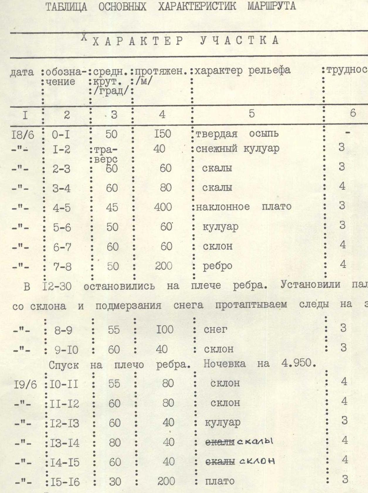
Table of main characteristics of the route
| Date | Designation | Average steepness, deg. | Length, m | Character of relief | Category of difficulty of the section | Condition | Weather condition | Pitons: rock | Pitons: ice | Pitons: bolt |
|---|---|---|---|---|---|---|---|---|---|---|
| 18/07 | R0–R1 | 50° | 150 | hard talus | 3 | Clear | simultaneous | |||
| R1–R2 | 40° | 40 | snowy couloir | 3 | icy; rockfalls | 2 | ||||
| R2–R3 | 60° | 60 | rocks | 3 | plate-like, destroyed | 5 | ||||
| R3–R4 | 60° | 80 | rocks | 4 | smoothed, monolithic | 8 | ||||
| R4–R5 | 45° | 400 | inclined plateau | 3 | snowy | simultaneous | ||||
| R5–R6 | 50° | 60 | couloir | 3 | icy | 4 | ||||
| R6–R7 | 60° | 60 | slope | 4 | thawing snow | 2 | ice axes | |||
| R7–R8 | 50° | 200 | ridge | 4 | thawing snow with rocky outcrops | 10 | ice axes | |||
| R8–R9 | 55° | 100 | snow | 3 | snowy slope | ice axes | ||||
| R9–R10 | 60° | 40 | slope | 3 | snow, rocks | 4 | ||||
| 19/07 | R10–R11 | 55° | 80 | slope | 4 | firn, rocky outcrops | 4 | |||
| R11–R12 | 60° | 80 | slope | 4 | firn, rocky outcrops | 4 | ||||
| R12–R13 | 60° | 40 | couloir | 3 | snow on ice, rocky outcrops | 4 | ||||
| R13–R14 | 80° | 40 | rocks | 4 | destroyed | 4 | 1 | |||
| R14–R15 | 60° | 40 | rocks, slope | 4 | snow, ice at the top | |||||
| R15–R16 | 30° | 200 | plateau | 3 | firn | simultaneous |
Explanations for the table of main characteristics of the route
R0–R1. Hard compacted talus. Movement is simultaneous, straight up, to the avalanche discharge from the couloir.
R1–R2. Traverse to the right - cross the mouth of the couloir with an avalanche gully. Rockfall is possible along the gully.
R2–R3. Destroyed plate-like rocks. Movement is alternate, with piton protection and through ledges. The plates are alive. Channel irons worked better.
R3–R4. Further movement - to the left and up. Steep smoothed rocks like "ram's foreheads". Piton protection, few cracks. Sections R2–R3 and R3–R4 are better passed early in the morning and as quickly as possible, as in case of rockfall, individual stones reach the route (there are many traces of stones on the rocks).
R4–R5. Long inclined snowy plateau with a pronounced gully in the middle. Movement is simultaneous, to the left of the gully, as far as possible, along the boundary of snow and rocks. In the absence of sun, the snow is hard, covered with firn. About 1.5-2 hours after being in the sun, the snow completely thaws and becomes avalanche-prone.
R5–R6. To the left and up, an implicit snow-ice couloir is crossed in the direction of a rocky outcrop. Rockfall is possible. Protection through pitons on rocky outcrops.
R7–R8. Movement along a snowy ridge with rocky outcrops. Protection - through pitons on rocky outcrops. Rocky outcrops are passed "head-on". On the shoulder of the ridge, behind a rocky outcrop, there is a convenient site for a bivouac.
R8–R9. Steep snowy slope. Protection through ice axes. Ascent along the snowy ridge to its junction with a rock of yellow color.
R9–R10. Traverse to the right along the snow under the yellow rock. Piton protection. Exit to a chain of outcrops on a steep pre-summit snowy slope.
R10–R11. Movement along a snowy slope along the left edge of rocky outcrops. Protection - pitons on rocky outcrops.
R11–R12. Movement to the left and up along a snowy slope to small rocky outcrops. Protection through pitons on rocks.
R12–R13. Traverse to the right to the pre-summit rocky belt. An implicit snow-ice couloir is crossed. Protection through pitons on rocks.
R13–R14. Rocky belt. Rocks are above medium difficulty, destroyed. Protection - chocks and ledges. To allow participants, except the first, to not remove crampons, a rope was organized on this section (40 m).
R14–R15. Pre-summit ascent. Steep snowy slope, with a layer of accreted ice at the top. Protection through an ice piton near a stone on a snowy "dome".
R15–R16. Summit dome. Firn plateau of medium steepness. Movement is simultaneous. Exit to the summit.