
ASCENT DOCUMENT
-
Ascent class: technical ascents.
-
Ascent area: 4.2.
-
Ascent object and route: p. 5000 m via the southwest buttress from Medvezhiy Glacier.
-
Estimated complexity category: 4B.
-
Route characteristics:
height difference — 1000 m; average slope — 60°; length of sections by category: 1 — 0 m, 2 — 560 m, 3 — 440 m, 4 — 540 m, 5 — 330 m.
-
Pitons driven: for belaying, for anchors, etc.
rock pitons 53, ice screws 9
-
Total climbing hours: 15 hours.
-
Number of nights: 1 overnight stay on the shoulder of the buttress.
-
Group composition: leader — SOLONNIKOV V.A., International Master of Sports,
participants:
| BURZOV | Yu.V. | Master of Sports | ORLOV | B.K. | Candidate for Master of Sports |
|---|---|---|---|---|---|
| GRACHEV | A.B. | Master of Sports | PAVILAINEN | V.D. | Candidate for Master of Sports |
| VEDERNIKOV | V.V. | Candidate for Master of Sports | STEPANOV | N.V. | Candidate for Master of Sports |
| MANOILOV | Yu.S. | Candidate for Master of Sports | CHUFARIN | V.A. | 1st sports category |
| NAZAROV | O.V. | Candidate for Master of Sports | EPSHTEIN | A.K. | 1st sports category |
-
Group coach: International Master of Sports SOLONNIKOV V.A.
-
Departure to the route: July 10, 1976.
Return to base camp: July 11, 1976.
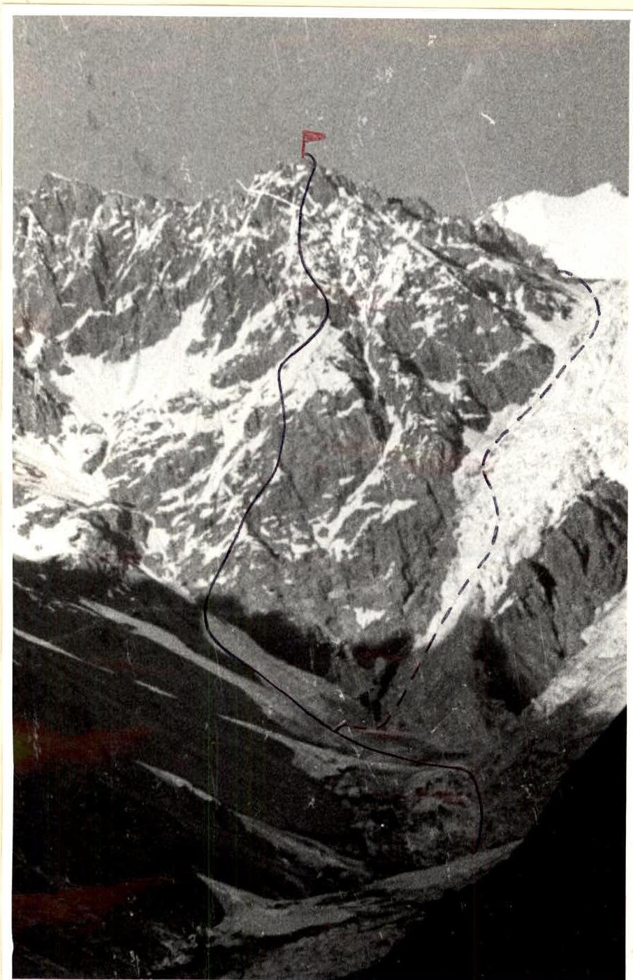
Peak 5000 m — first ascent route — descent route
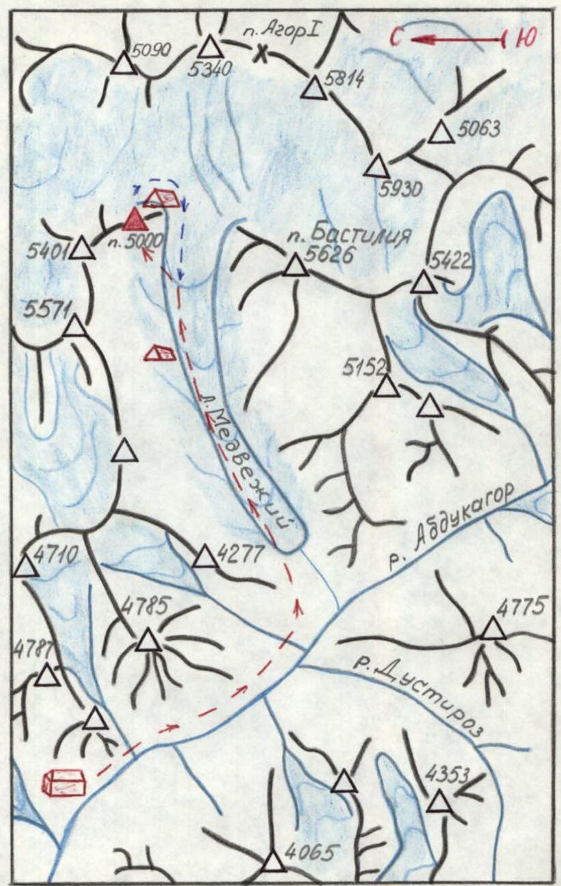
Route map — base camp — intermediate camps — approach route — descent route
Southwest buttress of Peak 5000 m — first ascent route — descent route — overnight stay on the route
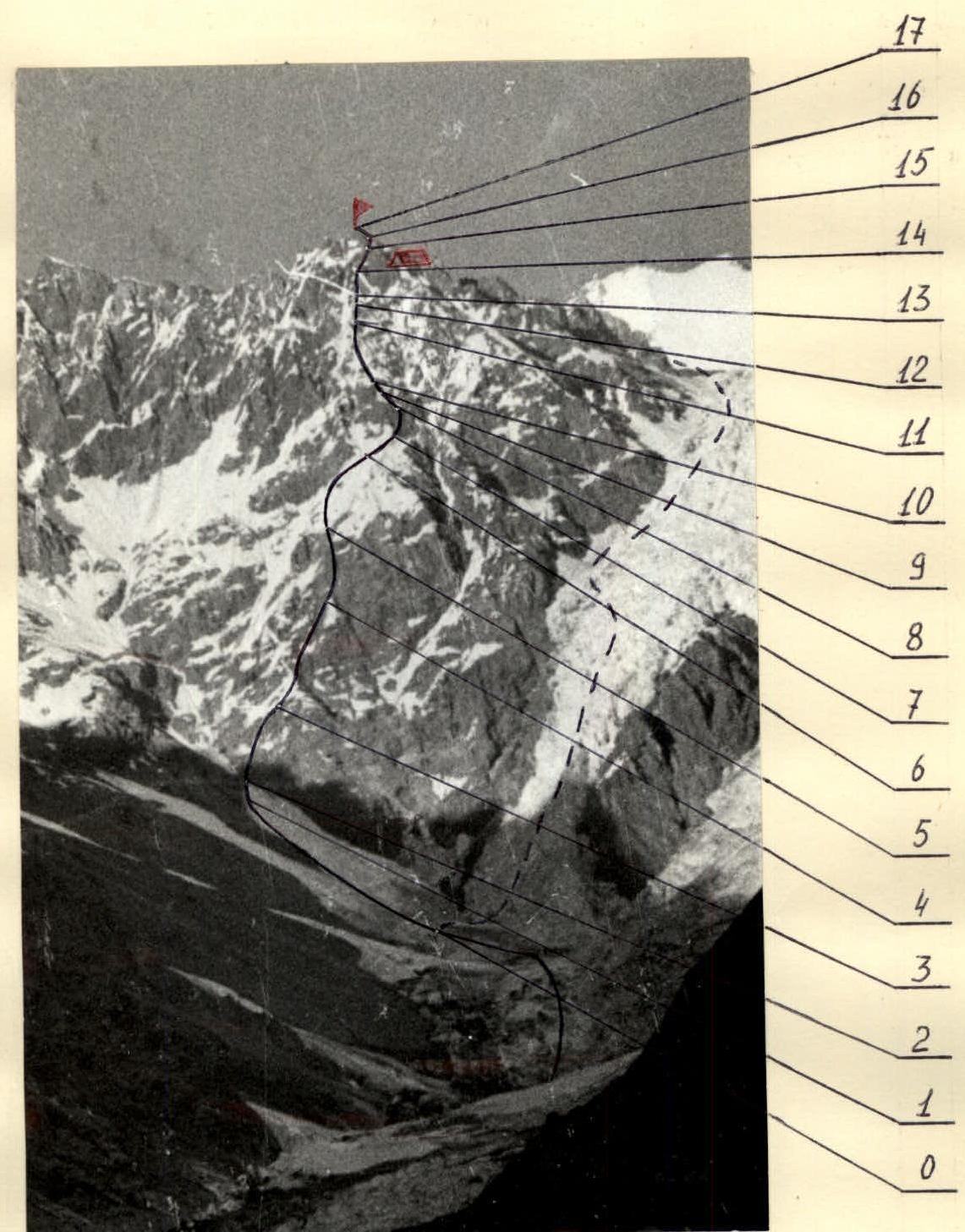
Profile of the southwest buttress of Peak 5000 m — first ascent route — descent route — overnight stay on the route
DESCRIPTION OF THE ROUTE
The route begins from the snowfields at the level of the beginning of the icefall in the upper reaches of Medvezhiy Glacier. The exit to the snowfields goes through the gaps and drops of the icefall to the left of the direction. This part of the icefall is traversed in crampons, sometimes with alternating belay.
Crossing the snow-covered bergschrund, we exit onto the snow slope of a wide, narrowing upward couloir (R0–R1). Movement is along the left side of the couloir under the slopes composed of destroyed rocks, to a narrow rock-ice neck.
The ascent up the couloir must be done early in the morning, as later there is a risk of wet avalanches.
Using a pendulum motion with careful belaying, we cross the narrow ice gully (R1–R2).
Then 80 m to the right and upward along the destroyed rocks of the eroded buttress (R2–R3).
- Belaying through outcrops and pitons.
- Alternating movement.
Further ascent is along the snowfields and not clearly defined ridges of the buttress (R3–R4).
- Simultaneous and alternating movement with belaying through an ice axe.
Passage of the rock belt (R4–R5):
- slabs
- inner corner
- wall
- destroyed blocks
Difficult climbing.
Further ascent is up the snowy couloir along the rocks of the buttress (R5–R6). In the upper part of the couloir, movement is alternating with belaying through an ice axe and pitons. Under the snow — ice. In August, the couloir will be icy. The couloir turns into an ice gully. Crossing it along a steep snow-ice slope (R6–R7), we exit onto a rock spur extending to the right from the buttress.
Then upward along the destroyed rocks (R7–R8), movement is alternating, rocks are of medium difficulty. Again, exit onto the buttress. First, a snow-ice slope, and then an ice slope to a rock island (R8–R9). Movement is on snow with belaying through an ice axe, and then with step-kicking in ice. On the rocks, piton belaying is organized. On the rocks, 30 m to the ridge (R9–R10).
Then along the snow-ice ridge (R10–R11), we approach under a rock pinnacle (R11–R12), which is first overcome directly (30 m), and then to the left along steep slabs (50 m).
Ahead is a loose slope and a steep destroyed rock ascent (R12–R13), which can be bypassed to the right along ice and loose snow.
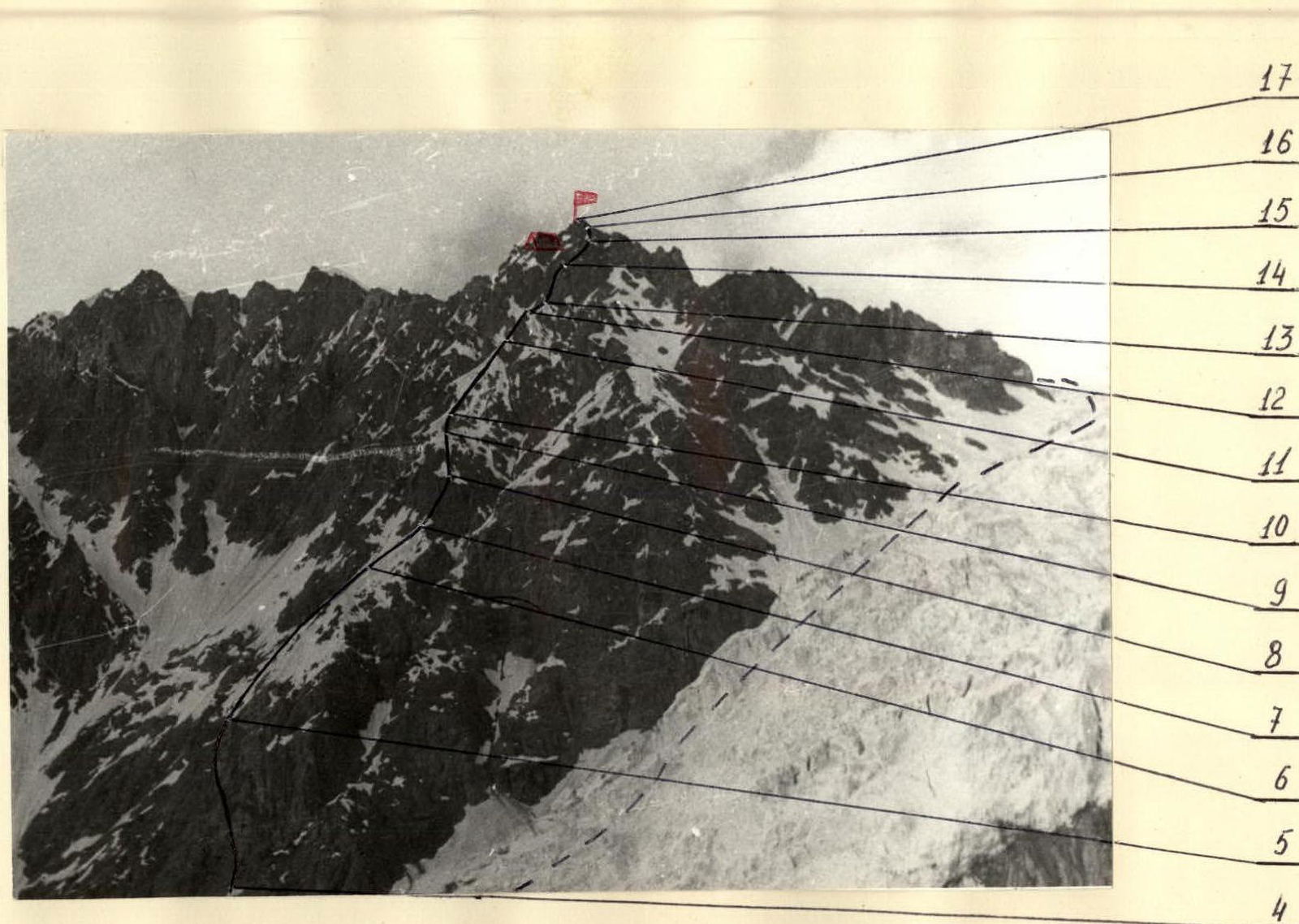
Ahead is the wall of the subpeak. Steep destroyed rocks (R13–R14). Movement is to the right and upward to a clearly defined shoulder in the ridge extending from the summit to the south towards the icefall. First, directly upward 15 m — wall, then traverse to the right under an overhanging belt — 10 m and then upward through a cornice along steep blocks to inclined slabs to a not clearly defined rock ridge. Difficult climbing. To pass the cornice, a ladder can be used. There is a high risk of rockfall.
Then upward along the not clearly defined rock ridge (R14–R15), consisting of large live blocks, and exit onto the shoulder. Here, an overnight stay can be organized.
Crossing the ice gully, along the rocks, we exit onto the south ridge (R15–R16) and along it, ascent to the summit (R16–R17).
Descent is along the snowy slopes to the upper plateau of Medvezhiy Glacier. Then along the right edge of the icefall, descent to the lower part of the glacier and further to the base camp.
Passage of the icefall is recommended in the first half of the day.
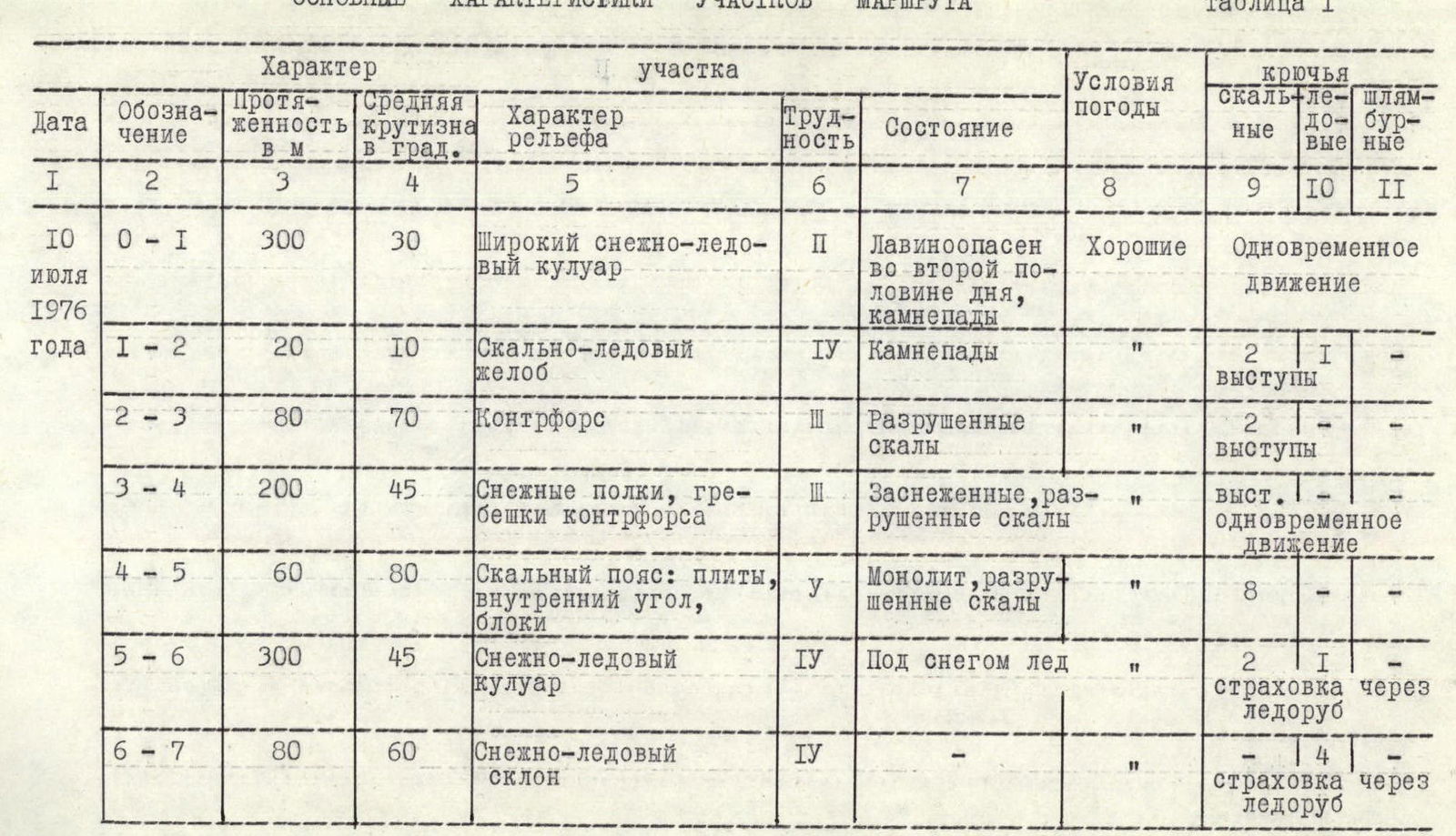
MAIN CHARACTERISTICS OF THE ROUTE SECTIONS
Table 1
| Date | Designation | Length in m | Average slope in degrees | Terrain characteristics | Difficulty | Condition | Weather conditions | Rock pitons | Ice screws | Bolts |
|---|---|---|---|---|---|---|---|---|---|---|
| July 10, 1976 | R0–R1 | 300 | 30 | Wide snow-ice couloir | 2 | Avalanche danger in the second half of the day, rockfall | Good | 10 | 11 | – |
| R1–R2 | 20 | 10 | Rock-ice gully | 4 | Rockfall | " | 2 | 1 | – | |
| R2–R3 | 80 | 70 | Buttress | 3 | Destroyed rocks | " | 2 | 1 | – | |
| R3–R4 | 200 | 45 | Snow shelves, ridges of the buttress | 3 | Snow-covered, destroyed rocks | " | 1 | 4 | – | |
| R4–R5 | 60 | 80 | Rock belt: slabs, inner corner, blocks | 5 | Monolith, destroyed rocks | " | 8 | – | – | |
| R5–R6 | 300 | 45 | Snow-ice couloir | 4 | Ice under snow | " | 2 | 1 | – | |
| R6–R7 | 80 | 60 | Snow-ice slope | 4 | – | " | 4 | – | – | |
| R7–R8 | 100 | 65 | Ridge of the buttress | 3 | Destroyed rocks | Good | 4 | – | – | |
| R8–R9 | 100 | 50 | Snow-ice slope | 4 | Rockfall | " | 3 | 3 | – | |
| R9–R10 | 30 | 75 | Wall | 5 | Monolith | " | 4 | – | – | |
| R10–R11 | 200 | 25 | Snow-ice ridge | 2 | Ice under snow | " | – | – | – | |
| R11–R12 | 80 | 75 | Pinnacle, slabs | 5 | Monolith | " | 10 | – | – | |
| R12–R13 | 60 | 50 | Ridge | 3 | Destroyed rocks | " | – | – | – | |
| R13–R14 | 100 | 85 | Wall, cornice, blocks, inclined slabs | 5 | Many loose rocks | " | 11 | – | – | |
| R14–R15 | 60 | 70 | Ridge of large blocks | 5 | " | " | 6 | – | – |
Departure from the overnight stay on Medvezhiy Glacier — 5:30. Stop for a bivouac — 19:30. Total climbing hours for the day — 13.5. Overnight stay on the shoulder of the buttress, conditions good.
Table 1 (end)
| Date | Designation | Length in m | Average slope in degrees | Terrain characteristics | Difficulty | Condition | Weather conditions | Rock pitons | Ice screws | Bolts |
|---|---|---|---|---|---|---|---|---|---|---|
| July 11, 1976 | R15–R16 | 40 | 65 | Rock-ice wall | 4 | Icy rocks | Good | 2 | – | – |
| R16–R17 | 60 | 20 | Snow ridge | 2 | Simultaneous movement | " | – | – | – |
Departure from the overnight stay on the shoulder of the buttress — 7:00. Arrival at the summit — 8:30. Total climbing hours — 1 hour 30 minutes.