PEAK CHETYREKH 6299
I. Brief Geographical Description of the Area and Climbing Object
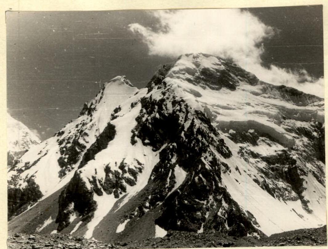
The object of our ascent — Peak Chetyrekh (6299 m) — is located in the northwestern Pamir, in the western branch of the Akademiya Nauk Range. The node dividing the range into western and eastern branches is the massif of Peak Ahmadi Donisha (6666 m), which is connected by saddles to both the eastern branch, ending with the peaks Muzzhilga, Sandal, and Shilbe (Mazarskie Alpy), and to its western branch, which begins with Peak Chetyrekh and ends with the grandiose peak of Peak E. Korzhenevskoi.
The southern slopes of Peak Chetyrekh drop down to the Moskvina Glacier, in the Fortambek valley, while the northern slopes descend into the Aiu-dzhilga valley, from where the ascent was made.
The summit of Peak Chetyrekh had already been reached from the south via the simplest route, but the path from the north, from Aiu-dzhilga, remained untrodden.
The reconnaissance showed that the virtually only path to the summit from the Aiu-dzhilga valley is an ascent to the saddle between Peak Ahmadi Donisha and Peak Chetyrekh, followed by an ascent along the ridge to the summit.
II. Brief Description of Climbing Conditions in the Area
a) Terrain Features
- The rocks forming Peak Chetyrekh and its surrounding peaks are very loose and fragile, resulting in abundant talus and moraines in the valley.
- Despite this, the massif of Peak Chetyrekh has many steep rocky walls and buttresses, but protection on them is quite challenging due to the fragility of the rock.
b) Weather Conditions
Since the Akademiya Nauk Range is a natural climatic barrier in the Pamir, the area of our ascent is one of the most humid regions of the Pamir.
Here, constant westerly winds prevail, sometimes reaching great strength.
Thus, the ascent area is characterized by unstable weather with the following characteristics:
- significant precipitation
- strong winds
- low temperatures
c) Exploration of the Area
The Aiu-dzhilga valley area was not visited by climbers until 1966. Currently, participants of the CS "Spartak" expedition, which included our group, made several first ascents to peaks in the area via routes of 3rd to 5th category difficulty.
III. Reconnaissance
On July 26, 1966, the group conducted a reconnaissance sortie to the foot of the saddle between Peak Ahmadi Donisha and Peak Chetyrekh. The goal was to find the simplest and safest path to the saddle.
The reconnaissance revealed that the path near Peak Ahmadi Donisha, which seemed simpler, was dangerous due to avalanches. Observations showed that avalanches on this slope do not start until around 10:00. Therefore, a more complex but relatively safe path (until 14:00–15:00) was chosen to ascend to the saddle on the right-hand side, above the ice falls.
IV. Tactical Ascent Plan
The reconnaissance showed that the most technically and tactically challenging and dangerous section of the route would be the part up to the saddle. The ridge section of the route, considering the high altitude and deep loose snow typical for these heights, would be more physically demanding.
Accordingly, it was necessary to devise an ascent plan that, while ensuring complete safety during the ascent to the saddle, would allow participants to approach the ridge section of the route relatively fresh.
Taking into account observations of avalanches, it was decided to ascend to the saddle over two travel days, so that on the first day, we could set up camp no later than 14:00 on a rocky outcrop under overhanging cliffs. The next day, we would pass the dangerous part of the ice slope early in the morning and camp on the saddle by the end of the day.
This tactical plan was executed.
V. Group Composition
The group set out on the ascent with the following composition:
- Shistko V.I., CMS, leader
- Konoplev K.A., CMS, deputy leader
- Kolchin A.M., 1st sports category, participant
- Akinfiev B.K., 2nd sports category, "
- Borisenok O.N., 2nd sports category, "
- Koltsov A.I., 2nd sports category, "
- Nechaev B., 2nd sports category, "
The rope team distribution was as follows:
- I rope team: Shistko—Borisenok
- II rope team: Koltsov—Kolchin
- III rope team: Konoplev—Akinfiev—Nechaev
All participants successfully completed the tasks set for the group.
VI. Route Assessment
The combined, mainly ice-and-snow route to Peak Chetyrekh taken by the group is very complex both technically and tactically: only during the ascent, 22 ice screws and 10 rock pitons were hammered in, and almost the entire descent was made using rope descents.
On the descent, 24 ice screws and 6 rock pitons were also hammered in. The steepness of the ice slope reached up to 70°, with a height difference of approximately 250–300 m on slopes of such steepness. The rocky sections on this route were above average difficulty, but during our ascent, all rocks were covered with ice.
Snow sections of the route are characterized by large cornices (in the ridge part) as well as deep and loose snow on the slopes. Therefore, we had to dig snow trenches up to 1 m deep or more.
The route is safe only with proper tactics for its passage. Due to the avalanche danger, it is necessary to correctly choose the time and path of movement, as well as the time and place to set up camp during a significant part of the daylight.
Otherwise, the group might be caught by daytime avalanches on the steep ice slope.
It is also necessary to consider that such heavy ice and snow work was carried out at an altitude of around 6000 m or more.
Taking all the above into account, the group assesses the route as category 5B difficulty.
Leader, CMS V.I. Shistko.
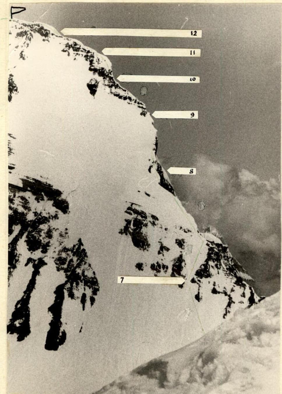
Eastern ridge of Peak Chetyrekh (photo from Peak Ahmadi Donisha)
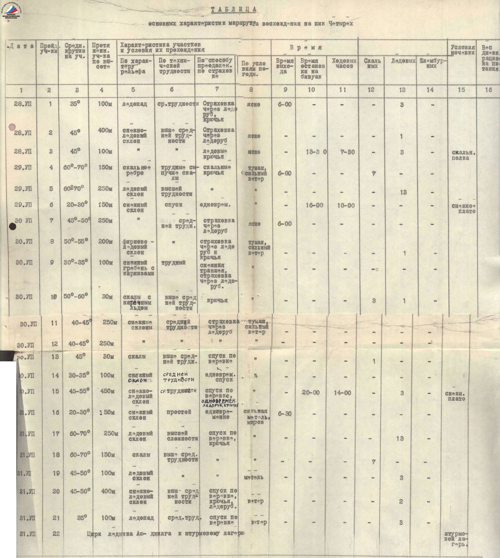
Table of Main Characteristics of the Ascent Route to Peak Chetyrekh
| Date | Section | Average Steepness | Length | Terrain Characteristics | Technical Difficulty | Method of Passage and Belay | Weather Conditions | Departure Time | Camping Stop Time | Travel Hours | Rock Pitons | Ice Screws | Bolts | Camping Conditions | Food Ration Weight |
|---|---|---|---|---|---|---|---|---|---|---|---|---|---|---|---|
| 28.VII | 1 | 35° | 100 m | icefall | medium difficulty | Belay via ice axe | clear | 6:00 | — | — | 3 | — | — | — | — |
| 28.VII | 2 | 45° | 400 m | snow-ice slope | above medium difficulty | Belay via ice axe | clear | — | — | — | 1 | — | — | — | — |
| 28.VII | 3 | 45° | 100 m | — | — | Ice screws | clear | — | 13:30 | 7:30 | — | 3 | — | — | — |
| 29.VII | 4 | 60°–70° | 150 m | rocky edge | difficult, loose rocks | rock pitons | fog, strong wind | 6:00 | — | — | 7 | — | — | rocky ledge | — |
| 29.VII | 5 | 60°–70° | 250 m | ice slope | highest difficulty | " | " | — | — | — | — | 13 | — | — | — |
| 29.VII | 6 | 20°–30° | 150 m | snow slope | descent | simultaneous | " | — | 16:00 | 10:00 | — | — | — | — | — |
| 30.VII | 7 | 45°–50° | 250 m | — | above medium difficulty | belay via ice axe | clear | 6:00 | — | — | — | — | — | — | — |
| 30.VII | 8 | 50°–55° | 200 m | firn-ice slope | — | belay via ice axe and screws | fog, strong wind | — | — | — | — | 1 | — | snow plateau | — |
| 30.VII | 9 | 30°–35° | 100 m | snowy ridge with cornices | difficult | snow trench, belay via ice axe | — | — | — | — | — | — | — | — | — |
| 30.VII | 10 | 50°–60° | 30 m | rocks with ice coating | above medium difficulty | pitons | — | — | — | — | 3 | 1 | — | — | — |
| 30.VII | 11 | 40°–45° | 250 m | snowy slopes | medium difficulty | belay via ice axe | fog, strong wind | — | — | — | — | — | — | — | — |
| 30.VII | 12 | 40°–45° | 250 m | " | " | " | " | — | — | — | — | — | — | — | — |
| 30.VII | 13 | 45° | 30 m | rocks | above medium difficulty | rope descent | " | — | — | — | — | — | 1 | — | — |
| 30.VII | 14 | 30°–35° | 100 m | snowy slope | medium difficulty | simultaneous descent | " | — | — | — | — | — | — | — | — |
| 30.VII | 15 | 45°–55° | 450 m | snow-ice slope | medium difficulty | rope descent, simultaneous, ice axe, screws | " | — | 20:00 | 14:00 | — | 3 | — | snow plateau | — |
| 31.VII | 16 | 20°–30° | 150 m | snowy slope | easy | simultaneous | heavy snowstorm, frost | 6:30 | — | — | — | — | — | — | — |
| 31.VII | 17 | 60°–70° | 250 m | ice slope | highest complexity | rope descent, screws | " | — | — | — | — | 13 | — | — | — |
| 31.VII | 18 | 60°–70° | 150 m | rocks | above medium difficulty | " | " | — | — | — | 7 | — | — | — | — |
| 31.VII | 19 | 45°–50° | 100 m | ice slope | " | rope descent, screws | snowstorm | — | — | — | — | 3 | — | — | — |
| 31.VII | 20 | 45°–50° | 400 m | snow-ice slope | above medium difficulty | rope descent, ice axe | wind | — | — | — | — | 2 | — | — | — |
| 31.VII | 21 | 35° | 100 m | icefall | medium difficulty | rope descent | wind | — | — | — | — | 3 | — | assault camp | — |
| 31.VII | 22 | — | — | Aiu-dzhilga glacier cirque | — | to the assault camp | — | — | — | — | — | — | — | assault camp | — |
Team Captain V.I. Shistko.