
Ascent
to Peak Kommunizma from Walter Glacier via the spur with an exit to the ridge between Peaks Izvestiy and 50th Anniversary of VLKSM.
Protocol No. 422 dated 09.11.1976. Classify the route: traverse of Peak 6700 m — Peak Kommunizma with ascent via the northwest spur and Voykov Ridge, ice and snow. Credit the group with the first ascent.
First Ascent
by the MGS SDSO "Burevestnik" group, led by N. Cherny.
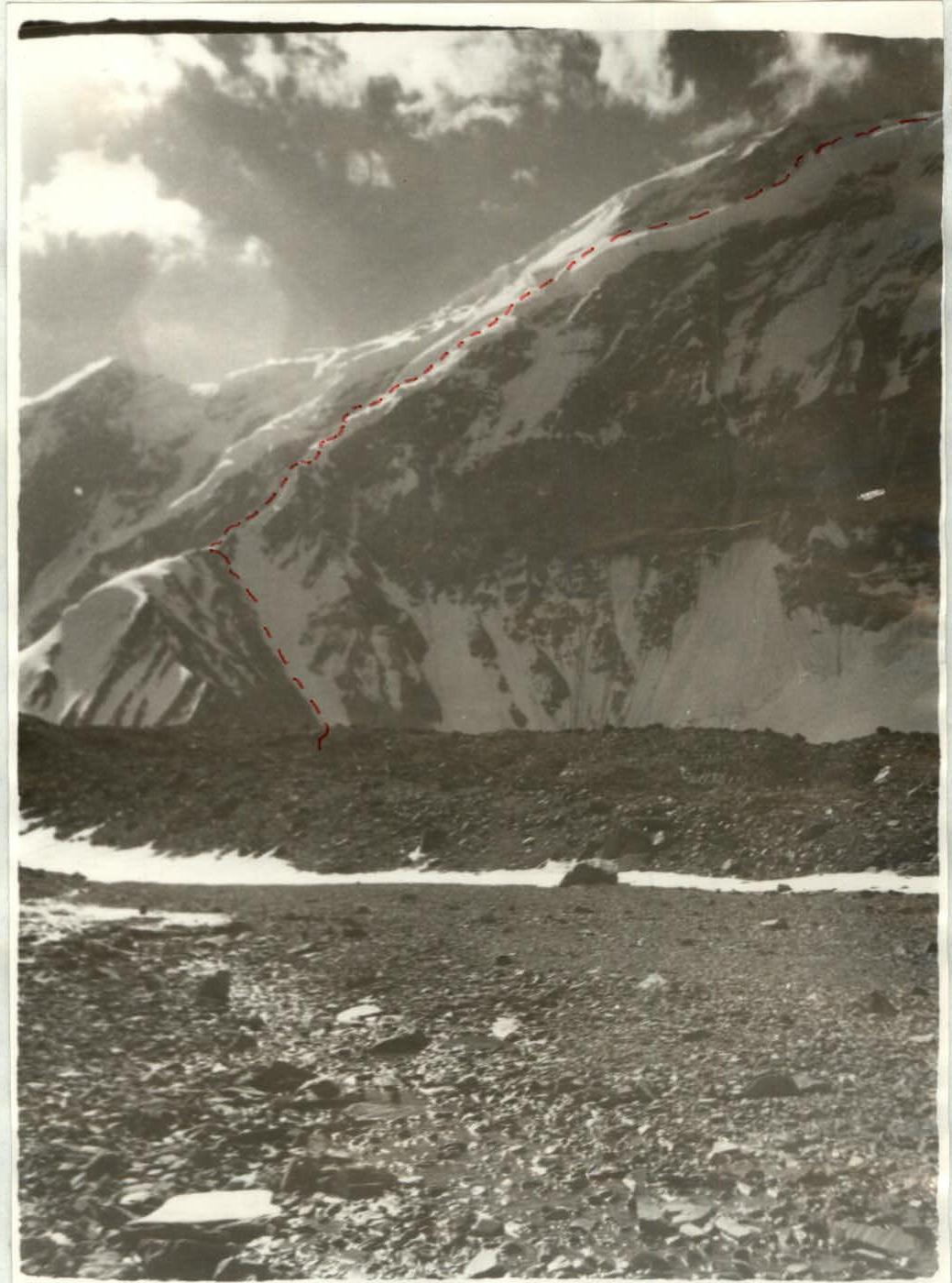
Peak Kommunizma is located in the central part of the Pamir Mountains, at the junction of the Peter I and Academy of Sciences ranges. Its northwest slopes descend onto the Pamir Firn Plateau. The plateau drops steeply to the north onto the Walter and Traube glaciers. The northern slopes of Peaks 50th Anniversary of VLKSM (6700 m) and Izvestiy descend onto the first glacier.
Two routes to Peak Kommunizma have been established from Walter Glacier: the Borodkin route, which exits onto the plateau, and the Bezzubkin route, which exits onto Peak 50th Anniversary of VLKSM. The MGS SDSO "Burevestnik" group made an ascent of Peak Kommunizma via a new route from Walter Glacier. The route follows a snow and ice spur that leads to the ridge between Peak Izvestiy and Peak 50th Anniversary of VLKSM. From there, the group followed a previously established path via Peak 50th Anniversary of VLKSM and then along the northeast ridge of Peak Kommunizma to its summit. The descent followed the ascent route down to the saddle between Peak Kommunizma and Peak 50th Anniversary of VLKSM, then the group descended onto the firn plateau and along the "Burevestnik" ridge to Fortambek Glacier.
The group departed from the base camp with the following members:
- Cherny N.D. — CMS, leader.
- Bogomolov A.M. — CMS, participant.
- Zasetsky V.G. — CMS, participant.
- Ivanova T.V. — CMS, participant.
- Rybinsky V.A. — CMS, participant.
- Tarkhnishvili D.I. — CMS, participant.
- Firsov V.P. — CMS, participant.
- Shpolyansky V.N. — CMS, participant.
Prior to the ascent, the group conducted acclimatization climbs on Peak MFTI and Peak Chetyrekh (6400 m) category 6B.
Day 1
June 17, 1976. The group departed from the base camp at 7:00 AM and, moving along the right (orographic) moraine of Walter Glacier, reached the foot of the route in 2 hours and 30 minutes.
The lower part of the spur appears as a large snow and ice cushion, rising 500–600 m above the glacier. There are alternative ascent options:
- to the right via a couloir;
- straight up from the glacier via a snow and ice slope.
The group used the first option. They crossed the glacier and, via a scree slope, approached the couloir leading to the start of the snow and ice ridge above the cushion. The couloir's steepness is 40–45°. Movement was mostly simultaneous, with some sections traversed alternately with protection using rock outcrops or pitons.
About 150 m from the top of the couloir, the group exited onto the snow cushion via its left-hand side and set up camp.
Day 2
June 18, 1976. The first rope team began moving at 9:00 AM. From the snow cushion where they had spent the night, they approached the start of the snow and ice ridge. The ridge is sharp, with a steepness of 40–45°, and ice under a layer of snow. Movement was alternate, with protection using ice screws.
The upper part of the ridge, where the steepness increased, was covered in a deep layer of loose snow. Moving through this snow and organizing protection was highly unpleasant. Therefore, from the last piton, Tarkhnishvili swung onto an adjacent lateral ridge that converged with the main ridge at the base of a rock wall. The lateral ridge proved more passable, and Tarkhnishvili reached the base of the rock wall. The other participants ascended to the same point via the main ridge using the rope.
The rock wall was steep (up to 75°) and heavily eroded. The entire group traversed it without backpacks, which were then pulled up. Protection was using pitons. The wall led to a short, scree-covered ridge where the group set up camp.
Day 3
July 19, 1976. From the campsite, the group moved along a broad snow and ice ridge to the first ice ramp. Movement along the ridge was simultaneous. The ice ramp appeared as a sheer drop in the spur, and ascent was possible via the right-hand slope. Since the slope faced northwest, the ice was very hard in the morning, requiring step-cutting for almost the entire ascent to the ridge crest. Ropes were fixed on the crest for the group's ascent. Further along the sharp snow ridge, about one rope length led to the upper part of the spur.
This section, R7, consisted of alternating snow ramps, gentler sections, and steep ice in places, with crevasses and small drops that could be bypassed. Movement was mostly alternate, with some sections traversed simultaneously with protection using ice axes or ice screws.
The group progressed along this section until 7:00 PM and camped on a relatively gentle slope (about 15–20°) at an altitude of approximately 6000 m.
Day 4
July 20, 1976. The altitude was already having an effect, and it was very cold at night. The weather remained clear. The group departed at 10:00 AM. Initially, they moved directly up a snow slope (4 rope lengths) and approached the firn drops encircling the shoulder of Peak Izvestiy. To the right, there was a passage through the drops leading to a snow slope with a steepness of 15–25°.
The slope was bounded below by drops and above by a series of crevasses and drops. The group moved up and to the right along this slope toward the saddle between Peak Izvestiy and Peak 50th Anniversary of VLKSM until 1:00 PM. They stopped for a snack among large seracs in the upper part of the slope and waited out the heat, which made progress very difficult on the snow fields.
At 3:30 PM, they began scouting a path to the saddle. Reconnaissance showed that the firn drops above the slope were impassable. Therefore, they planned to ascend via the rocks of Peak Izvestiy's shoulder, along the boundary with the drops.
At 4:30 PM, they began processing the route. Upon reaching the rocks, they had to cross a bergschrund via a snow bridge and then climb a 5-meter vertical rock face with a crack using pitons as footholds. From there, they ascended via icy rocks up and to the right onto a rock shoulder, from which they could exit onto snow slopes above the drops, descending directly from the saddle between Peak Izvestiy and Peak 50th Anniversary of VLKSM.
The rocks were steep, icy, and had few handholds. Their passage took a significant amount of time, so after processing the route, the participants descended to the daytime rest area and camped in a snow depression.
Day 5
July 21, 1976. In the morning, the group traversed the rocky section via the ropes laid the previous day and exited onto the slope descending directly from the saddle between Peak Izvestiy and Peak 50th Anniversary of VLKSM. Along the slope, moving up and to the right, the group reached the ridge between the two peaks by 12:00 PM. The snow on the slope was deep, requiring step-treading and regular changes of the lead.
Upon reaching the ridge, the group continued toward Peak 50th Anniversary of VLKSM and approached the rocks at the start of the ascent to its summit by 2:00 PM. Here, in a depression under the rocks, the group stopped for a daytime snack.
The ascent to the summit of Peak 50th Anniversary of VLKSM proceeded up its northern snow-covered slope, to the right and up along the route. The summit rock tower was bypassed on the right via snow, and they reached the summit at 5:00 PM. By this time, the weather had deteriorated: strong wind and overcast skies minimized their stay on the summit. They retrieved a note left by a team from Uzbekistan led by G. Petrov, who had traversed Peak Kommunizma — Peak E. Korzhenevskaya in 1975.
The descent from the summit to the saddle between it and Peak Kommunizma via large scree took about 30 minutes. The group camped on the saddle, utilizing prepared campsites for the first time.
Day 6
July 22, 1976. The group ascended along the north ridge of Peak Kommunizma to an altitude of 6900 m. The ridge consisted of a series of ramps with steepness varying from 20–40°, interspersed with gentler sections. Movement was possible both along the scree on the right-hand part of the ridge and on the snow on its left-hand part. The snow was very dense. The broad ridge allowed most of the group to proceed without being roped together. The weather was poor: overcast, cold, and strong wind. At 5:00 PM, the group camped on the scree ridge.
Day 7
July 23, 1976. The bad weather intensified overnight. The wind became stormy.
During the night, a guy line on one of the tents snapped, and the tent collapsed. Re-erecting it required significant effort.
At 9:30 AM, they set out for the summit but, after proceeding 300 m, decided to return to the tents due to the risk of frostbite in the strong wind.
Shpolyansky, who had felt unwell the previous day, reported feeling worse — apparently, altitude sickness. It was decided that he, along with Firsov, would descend with a tent and a stove.
At 1:00 PM, this pair began their descent.
At 4:30 PM, they were seen on the saddle between Peak Kommunizma and Peak 50th Anniversary of VLKSM.
Day 8
July 24, 1976. Second attempt to reach the summit. Departure was at 9:30 AM. The wind was almost as strong as the previous day. However, they couldn't wait any longer: supplies were running low, and the control deadline was approaching.
Moving along the northeast ridge of Peak Kommunizma:
- At 1:30 PM, they approached the final ramp — a sharp snow ridge with a cornice toward Bivachny Glacier.
- They moved alternately with protection using ice axes and rock outcrops.
- At 2:30 PM, the group reached the summit.
On the summit:
- They retrieved a note left by G. Petrov's team.
- The weather was poor: overcast, very strong wind, and cold.
Descent:
- Proceeded along the ascent route.
- At 5:00 PM, the group returned to the tents.
- They camped at the same location.
Day 9
July 25, 1976. At 10:00 AM, they began their descent. Initially, they descended to the saddle between Peak Kommunizma and Peak 50th Anniversary of VLKSM. From there, traversing left and down the southwest slope of Peak 50th Anniversary of VLKSM, the group descended onto the plateau by 3:00 PM. Movement on the descent was alternate, with protection using ice axes, ice screws, and rock pitons. They reached the middle of the plateau the same day and camped there.
Day 10
July 26° C. They continued moving along the plateau and met Shpolyansky and Firsov at Peak Parashyutistov at 11:00 AM. Shpolyansky was feeling well. The group then descended along the "Burevestnik" ridge and, by 7:00 PM, crossed Fortambek Glacier and reached the camp on Suloev Plain. The next day, the group returned to the base camp at the confluence of Moskvina and Walter glaciers.
Route Assessment
Based on the experience of previous ascents, the group assesses the route as category 5B. They compared it to the Borodkin route on Peak Kommunizma and the Budanov route on Peak Korzhenevskaya.
The route traversed is more challenging than those mentioned above but is considered sufficiently safe.
List of equipment taken by the group for the ascent:
- Main rope — 4 × 40 m.
- Auxiliary rope — 40 m.
- Rock hammer — 2 pcs.
- Ice axe — 8 pcs.
- Titanium rock pitons (various) — 12 pcs.
- Ice screws (VCSPS type and corkscrew) — 12 pcs.
- High-altitude nylon tent — 2 pcs.
- "Febus" stove — 2 pcs.
- "Vitalka" radio — 1 pc.
- Gasoline — 10 l.
- 2.5 l pots — 4 pcs.
- Carabiners — 30 pcs.
- Safety harness — 8 pcs.
- Crampons — 8 pairs.
The group was provisioned for 9 days at 450 g per person per day.
Table of key characteristics of the ascent route to Peak Kommunizma from Walter Glacier
| Date | Section No. | Average Steepness | Length (m) | Section Characteristics and Passage Conditions by Relief Type | Technical Difficulty and Passage Method | Protection and Insurance | Weather Conditions | Start Time | Stop Time | End of Movement Time | Ice Screws Driven | Rock Pitons Driven | Bolt Pitons Driven | Camping Conditions | Daily Ration Weight |
|---|---|---|---|---|---|---|---|---|---|---|---|---|---|---|---|
| 17 | 1 | 40° | 600 | Snow and ice couloir with rocky sides | Movement on ice and snow, occasional rock outcrops | Simultaneous movement, some sections alternate with protection using outcrops or pitons | Good weather | 18:00 | 7:00 | 11:00 | 3 | On snow cushion | 700 g | ||
| 18 | 2 | 45° | 400 | Snow and ice ridge | Ice covered in snow | Alternate movement, step-treading, and piton protection | Good weather | 18:00 | 9:00 | 10:00 | On scree and snow ridge | 500 g | |||
| 3 | 65° | 20 | Rock wall | Steep, eroded rocks with many loose stones | Alternate movement, piton protection | ||||||||||
| 19 | 4 | 30° | 200 | Snow and ice ridge | Snow on ice holds well | Simultaneous movement | Good weather | 19:00 | 9:00 | 10:00 | 4 | On snow slope at 15° | 500 g | ||
| 5 | 45–60° | 40 | Ice ramp | Steep ice with a crevasse at the base | Alternate movement, step-cutting, piton protection | ||||||||||
| 6 | 30° | 40 | Sharp snow ridge | Loose snow | Alternate movement, step-treading, ridge clearing, ice axe protection | ||||||||||
| 7 | 30° | 1400 | Snow and ice spur with ramps and gentler sections, many crevasses and drops | Snow, some loose, occasional ice outcrops, crossing crevasses on bridges | Mostly simultaneous, some sections alternate with protection using ice axes and ice screws | 6 | |||||||||
| 20 | 8 | 15–20° | 1000 | Traverse of slope up and to the right | Slope covered in snow and firn | Simultaneous movement, ice axe holds well | Good weather | 19:00 | 10:00 | 9:00 | Under rocks in a snow depression | 500 g | |||
| 9 | 50° | 150 | Rock ramp bypassing ice drops on the slope | Icy, eroded rocks, bergschrund with a snow bridge | Alternate movement, piton protection, using pitons as footholds, step-cutting in ice | 9 | |||||||||
| 21 | 10 | 20° | 500 | Snow slope descending from Peak Izvestiy's ridge | Snow, some crevasses and drops | Simultaneous movement, ice axe holds well | Clear in the morning, windy and overcast later | 18:00 | 10:00 | 8:00 | On the saddle between Peak Izvestiy and Peak 50th Anniversary of VLKSM | 500 g | |||
| 11 | 15° | 500 | Broad snow ridge of Peak 50th Anniversary of VLKSM, some rock outcrops | Dense snow with sastrugi, some rock outcrops | Alternate movement, ice axe protection | ||||||||||
| 12 | 35° | 600 | Ascent to Peak 50th Anniversary of VLKSM via the northern slope | Snow slope, deep snow, some ice | Alternate movement, ice axe protection | ||||||||||
| 13 | 30° | 400 | Descent along the ridge from Peak 50th Anniversary of VLKSM to the saddle | Broad rocky ridge, scree-covered | Simultaneous movement | ||||||||||
| 21 | 14 | 30° | 1200 | North ridge of Peak Kommunizma to its shoulder | Broad ridge, alternating scree and snow, some rocks | Mostly simultaneous, some sections alternate | Strong wind, cold, overcast | 18:00 | 10:00 | 8:00 | On the north ridge of Peak Kommunizma at 6900 m | 400 g | |||
| 23 | 15 | 10° | 1200 | Northeast ridge of Peak Kommunizma with some ramps | Gentle snow ridge | Dense snow, simultaneous movement | Strong wind, frost, overcast | 17:00 | 9:30 | 7:30 | 300 g | ||||
| 16 | 25° | 200 | Pre-summit ridge | Sharp snow ridge with a cornice toward Bivachny Glacier | Dense snow, alternate movement, protection using ice axe and rock outcrops |
A total of 20 ice screws and 16 rock pitons were driven.