The climbing object announced by the group of instructors of the international mountaineering camp "Pamir-76" is well-known among Soviet mountaineers. It is the highest point in the USSR - Peak Kommunizma (7495 m) with an ascent to the Big Pamir Firn Plateau via Borodkin's route. For this reason, this report omits a geographical overview of the area, the history of its development, and a description of the approaches to the route.
A few words should be said about the meteorological conditions in the area in July-August 1976.
- From July 5 to 20, the weather was stable: clear, with little wind even at heights up to 7000 m.
- After July 20, the weather became unstable. For example, on July 21, during the descent from Peak E. Korzhenevskaya, the group had to walk for a whole day with visibility not exceeding 500 m.
- From July 23 to 27, low cloud cover and continuous light rain were observed in the area. At an altitude of 7000 m, there was a very strong wind, and snow caught the group of the Tajik Medical-Biological Expedition, which, after waiting out the bad weather in a storm camp, was forced to abandon the ascent.
- However, during the ascent on August 7-9, the weather was good, but it was very cold: on the night of August 6-7, the minimum temperature at an altitude of 6000 m was –28 °C.
Acclimatization and training ascent
The group of climbers arrived at the Buluiev clearing as part of the collective of instructors of the international mountaineering camp "Pamir-76" on August 8, having previously made an acclimatization trip to an altitude of 4500 m in the Achik-Tash clearing area.
On July 1, all group members left the base camp for an acclimatization hike.
The main objectives of the exit were:
- Technical marking of the path and securing of periline ropes on the Bustard ridge;
- Acclimatization of participants.
The group went to the western end of the firn plateau and spent the night at an altitude of 5900 m.
On July 18, a group of instructors consisting of:
- Petrashko G.A. - leader,
- Studenin B.A.,
- Korovkin O.A.,
- Smirnov R.N.
moved to the Moskvina glacier, where from July 18 to 22 they made an ascent to Peak E. Korzhenevskaya via route 5B category of complexity (Budanov's path).
On July 22, the group returned to the base camp at the Suloev clearing. From July 23 to August 2, group members, performing their duties, climbed to the firn plateau twice to an altitude of 6000 m.
Ascent to Peak Kommunizma
Initially, it was planned that the group would start the route on August 1. However, the performance of official duties and then bad weather delayed the departure until August 4.
August 4. The group consisting of:
- Petrashko G.A. - leader,
- Studenin B.A.,
- Korovkin O.A.,
- Smirnov R.N.,
- Smirnov E.G.
left the base camp, descended along the Fortambek glacier to its confluence with the Moskvina glacier, and then ascended to the Walter glacier. By evening, the weather had deteriorated significantly. It started raining, and visibility dropped to 300-500 m.
August 5. The weather did not improve. Smirnov R.N. was forced to leave the group due to the need to return to the base camp.
August 6. In the morning, the weather improved slightly. Cloud cover rose to a height of 5800-6000 m.
At 5:30, the group left the camp. Excellent physical fitness and high-altitude acclimatization allowed the group to climb to the firn plateau on the same day.
At 21:00, a camp was set up at an altitude of 6000 m. The group gained 1800 m in altitude for the day.
August 7. After a difficult previous day, the group rested until 12:00. In the morning, E. Smirnov complained of throat pain. Examination by doctors of the medical-biological expedition ended with a recommendation for immediate descent. The entire group, due to the direct duties of the trainers-instructors of the "Pamir-76" mountaineering camp, could not start the descent. E. Smirnov began to descend with members of the medical-biological expedition, who began to evacuate their high-altitude camp.
At 13:00, the remaining three group members: Petrashko G.A. - leader, Studenin B.A., Korovkin O.A. - continued the ascent to Peak Kommunizma. The main objectives at this stage were:
- Monitoring and assistance to foreign climbers during ascent and descent;
- Ascent to Peak Kommunizma.
By 20:00, the group climbed to an altitude of 6900 m to the assault camp. There were 40 people in the camp. Of these, 32 climbers planned to start the summit assault the next day.
August 8. The group left the camp at 6:00. It was very cold, but otherwise the weather favored the ascent. The remaining climbers followed us with small breaks. By 12:00, we reached the pre-summit ridge, and at 13:00 - the summit of Peak Kommunizma. The descent from the summit began at 15:00, after the last foreign climbers reached the summit. On this day, 31 climbers reached the summit of Peak Kommunizma.
August 9. A Japanese climber fell seriously ill. He had to be transported to an altitude of 6000 m, wrapped in a tent. After 6000 m, he was led, supported under the arms, and continuously given stimulating injections. At 20:00, the group stopped for the night, about 1 km short of the western end of the firn plateau.
August 10. The patient felt somewhat better, allowing him to be taken down to the base camp.
Description of the ascent to Peak Kommunizma via Borodkin's route
From the camp located at the confluence of the Walter glacier and the Moskvina glacier, we proceed upward along the right side of the Walter glacier. The trail is well-marked.
Gradually, the glacier relief becomes calmer. To the right, a ridge is visible across the glacier, which we will need to climb.
After 40 minutes of walking, the Walter glacier becomes flat. There are no large crevices or fractures.
We cross the glacier in the direction of the ridge. The journey from the camp to the ridge takes just over 1 hour.
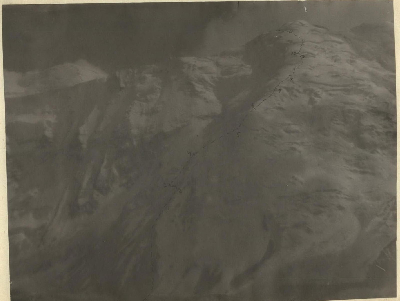
Section R0-R1
The beginning of the ascent goes along heavily destroyed rocks of the right counterfort. The rocks are simple but require maximum attention due to their severe destruction. Insurance is provided through ledges. Movement is simultaneous.
- Steepness of the section: 30-40°
- Length: 500 m
- Altitude gain: 300 m
Section R1-R2. The right rocky counterfort ends. Rock outcrops alternate with snow-ice fields. We pass the last large rocky outcrop on ice covered with a thin layer of snow. In some places, it is necessary to cut steps. Insurance is provided through rocky ledges. Movement is alternate. Average steepness is 40-45°. The length of the section is 80 m, altitude gain is 50 m.
Section R2-R3. Horizontal traverse of the ice slope to the left rocky ridge. Cutting steps. The slope steepness is 45°. Insurance is provided through rocky ledges. Movement is alternate with the use of railings. The length of the section is 50 m.
Section R3-R4. Ascent along a heavily destroyed rocky ridge. The section is simple but requires special caution. Average steepness is 35-40°. Length - 120 m, altitude gain 80 m.
We approach the end of the rocky counterforts. There are several excellent sites for overnight stays. The passage of sections R0-R4 took approximately 3 hours. After a short rest, we continue the ascent along the ridge.
Section R4-R5. Wide snowfields. Snow depth is 30-40 cm. Below is firm firn, and in some places, ice. Average steepness is 30-40°. Steepness of individual sections is up to 45°. Insurance is provided through an ice axe. Movement is simultaneous. The length of the section is 500 m, altitude gain is 300 m.
Section R5-R6. Continuation of the wide snowy ridge. We pass, slightly deviating to the left from the middle. The steepness of the slopes gradually increases. More often, there are slopes with a steepness of up to 45°. We overcome several crevices, one of which has a second wall about 2 m high. The snow is sometimes loose and deep. The length of the section is 200 m, altitude gain is 160 m.
Section R6-R7. We come closer to the center of the ridge, i.e., large drops appear on the left. After a short traverse to the right, we ascend along a snowy slope with a steepness of 35-45°. For about 20 meters, we have to walk through very deep, loose snow covering the grass. The length of the section is 220 m, altitude gain is 120 m.
Section R7-R8. Gradually, the snow becomes denser. The steepness of the slopes decreases. After about 200 m, we reach a gentle slope, where, through a layer of fresh snow, platforms cut into the firn five days ago by a group of climbers are felt. Steepness of slopes: 30-40°. Altitude gain: 100 m.
Time - 15:00. The passage of sections R4-R8 took about 5 hours. We take a one-hour break.
Section R8-R9. Snowy slopes of variable steepness (30-40°). In some places, loose deep snow. The length of the section is 400 m, altitude gain is 240 m. Movement is simultaneous. Insurance is provided through an ice axe.
Section R9-R10
To the left, there is a small snowy shoulder. A deceptive impression is created of reaching the edge of the firn plateau. We cross a crevice over a delicate snowy bridge. We traverse a slope with a steepness of 30°. The snow is very deep. After 60 m, it becomes clear that we need to exit to the ridge again on the right.
Section R10-R11. Wide snowy fields with a steepness of 30-35°. The snow is dense and not deep. At the end of the section, the steepness of the slopes increases - deviating from the ridge to the left, we enter a very wide crevice. The length of the section is 300 m, altitude gain is 160 m.
Section R11-R12. A wide crevice filled with snow. In some places, loose snow covers deep crevices. Movement is with alternate insurance. The length of the section is 60 m.
Section R12-R13. Ascent to the pre-summit ridge. The snow is dense. Movement is simultaneous. Average steepness is 35-40°. The length of the section is 180 m, altitude gain is 100 m.
Section R13-R14. Descent along a gentle snowy slope to the eastern end of the firn plateau. The length of the ridge is 600-800 m, altitude loss is 100 m.
The passage of sections R8-R14 took about 6 hours. For the day, the group climbed from the Walter glacier to the firn plateau, gaining a total of 1800 m.
August 7
Start of TE 00 operation
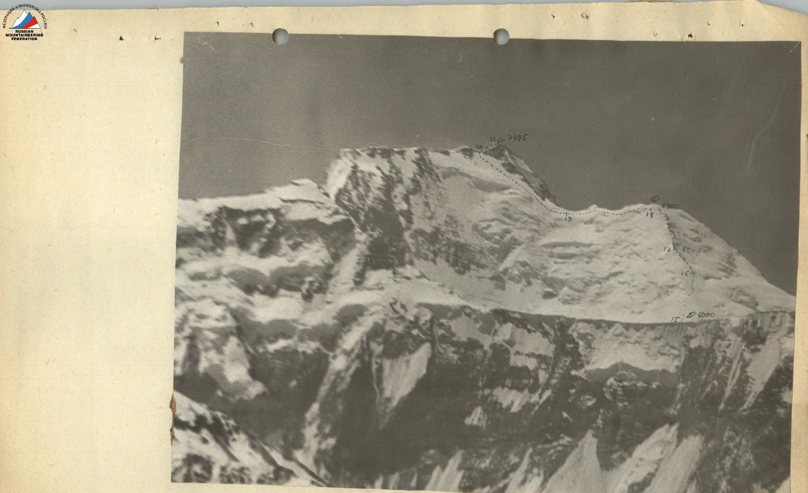
Section R14-R15
Crossed the firn plateau in the direction of the snowy slopes of Peak Kommunizma.
The length of the section is 1 km.
Section R15-R16
Gentle snowy slopes. Steepness is 30-40°. There are several small crevices. The snow is dense. The length of the section is 600 m, altitude gain is 300 m. Movement is simultaneous.
Section R16-R17
Gentle snowy slopes with rare rock outcrops. The snow is dense. Average steepness of slopes is 30-40°. The length of the section is 350 m, altitude gain is 200 m. Movement is simultaneous.
At 15:00, we reached the site of the fourth intermediate camp. After a short rest, the group resumed movement at 16:00.
Section R17-R18
Gentle firn slopes. Average steepness is 30-40°. In the lower part, there are rare rock outcrops. In the upper part, the steepness increases to 45°. The firn becomes hard.
- Length of the section: 700 m
- Altitude gain: 400 m
At 20:00, we reached the assault camp. Altitude 6900 m.
August 8
The group left the assault camp at 8:00. The whole day was clear and windless. It was very cold. The tracks of the previous group that climbed Peak Kommunizma on August 7 were completely snowed over.
Section R18-R19
From the assault camp, gradually losing altitude, we proceed along gentle slopes to the beginning of the ascent to Peak Kommunizma. The total length of the path is 500 m, altitude loss is 50 m.
Section R19-R20. Snow-firn slope with a steepness of 30-40°, leading to the pre-summit ridge. The length of the slope is 900 m, altitude gain is 630 m.
Movement is simultaneous.
Section R20-R21. Pre-summit ridge.
- Simple rocks
- Several firn slopes
The length of the ridge is 150 m, and the altitude gain is 15 m.
The group reached the summit at 13:00. We found a note from a group of instructors of the international mountaineering camp "Pamir-76" led by Galkin O.
Descent to the plateau via the ascent route, then along the plateau to its western end, and along the Bustard ridge to the Suloev clearing.
Peak Kommunizma

| Section | Terrain | Insurance | Steepness (degrees) | Complexity assessment | Length (meters) | Altitude gain | Notes |
|---|---|---|---|---|---|---|---|
| R0-R1 | Destroyed rocks | through ledges | 30-40° | simple | 500 | 300 | |
| R1-R2 | Ice slope with rocky outcrops | through ledges | 40-45° | medium | 80 | 50 | |
| R2-R3 | Traverse of ice slope, cutting steps | through ledges | 45° | medium | 50 | - | |
| R3-R4 | Heavily destroyed rocky ridge | through ledges | 35-40° | medium | 120 | 80 | Excellent sites at the end |
| R4-R5 | Snowfields | through ice axe | 30-40°, 45° | simple | 500 | 330 | |
| R5-R6 | Wide snowy fields, crevices | through ice axe | 35-40°, 45° | medium, difficult | 300 | 160 | |
| R6-R7 | Snowy slope, deep snow | through ice axe | 35-45° | difficult | 220 | 120 | |
| R7-R8 | Snowy slope | through ice axe | 30-40° | simple | 200 | 100 | |
| R8-R9 | Snowy slope, deep snow | through ice axe | 30-40° | simple | 400 | 240 | |
| R9-R10 | Traverse of snowy slope, very deep snow, crevice | through ice axe | 30° | difficult | 60 | - | |
| R10-R11 | Snowy slope | through ice axe | 30-35° | simple | 300 | 160 | |
| R11-R12 | Wide crevice, crevices | through ice axe | 0° | difficult | 60 | - | |
| R12-R13 | Snowy ridge | through ice axe | 35-40° | simple | 180 | 100 | |
| R13-R14 | Snowy ridge with rock outcrops | through ice axe | 10-20° | simple | 800 | -100 | Descent for overnight stay |
| R14-R15 | Firn plateau | simple | 1000 | 0 | |||
| R15-R16 | Gentle snowy slopes | through ice axe | 30-40° | simple | 600 | 300 | |
| R16-R17 | Snowy slopes with rock outcrops | through ice axe | 30-40° | simple | 350 | 200 | |
| R17-R18 | Firn slope | through ice axe | 30-40°, 45° | simple | 700 | 400 | Overnight stay |
| R18-R19 | Descent along snowy slopes | through ice axe | medium | 500 | -50 | ||
| R19-R20 | Snow-firn slope | through ice axe | 30-40° | medium | 900 | 630 | |
| R20-R21 | Pre-summit ridge, simple rocks | through ledges | medium | 150 | 15 |