


П. Brief Geographical Description of the Climbing Area
Central Pamir is bounded to the north by the Muksuv River (below Surkhob) and to the south by the Bartang River (above Kudaroy). To the east, the area is bounded by the Zulumart Range, and to the west by the western spurs of the Petra Pervogo and Darvaz Ranges, as well as the large arc of the Pyanj River near Khorog. Central Pamir is a concentration of high ranges, powerful glaciers, and giant peaks.
Most of the ranges in the area have a latitudinal direction. The northernmost of these is the Petra Pervogo Range. To the south lies the Darvaz Range, carrying peaks such as Peak Garmo (6595 m) and Arnavad (6083 m).
The base camp of the "Vysochnik" alpine camp, which was visited by the team from the Dnipropetrovsk Regional Council of the "Avangard" Sports Society, was located in the upper reaches of the Vanch Valley. The Vanch Valley is bounded:
- to the north by the Darvaz Range,
- to the south by the Vanch Range.
The first topographic survey of the area was conducted by N. G. Dorofeev in 1928, who penetrated the Geographical Society Glacier (GOG) from the Fedchenko Glacier.
A more detailed topographic survey was carried out in 1949 by a group of topographers and glaciologists led by R. D. Zabirov.
The object of the first ascent was chosen as a section of the Academy of Sciences Range, located between the Fedchenko and Geographical Society Glaciers. The alpine exploration of the area had not previously touched this massif, as all previous expeditions had worked:
- either in the area of the Komosomolsk Glacier (one of the right tributaries of the GOG),
- or had made ascents to Peak Komakademii (6439 m).
III. Climbing Conditions in the Area
a) Remoteness of the Area
The base of the "Vysochnik" alpine camp is located in the city of Osh. The camp itself is situated in the upper reaches of the Vanch River, near the tongue of the GOG. The journey from the base camp to the specified location takes 2.5 to 3 days (by car via Khorog or Dushanbe).
The nearest settlement is Poi-Mazar, located 25 km from the camp. Further up the valley, 12 km from the alpine camp, is the Khrustalny mine, with which there is a vehicular connection.
b) Relief Features
The area is characterized by a significant amount of snow and ice. Almost all northern slopes are snow-ice with large overhanging cornices. The snow on the ridges is loose and powdery, making movement across such areas difficult. The rocks are heavily destroyed, snow-covered, and have sections of flow ice.
Considering the severe frosts at high altitudes, the destroyed rocks are not always rockfall-prone. Rockfalls should be feared after 10:00 ± 11:00 am at altitudes below 5000 m.
c) Weather Conditions
Weather conditions are determined by the location of the area in the center of the Northwest Pamir. Like the entire Northwest Pamir, the weather is unstable. The average precipitation in the Vanch River valley is greater than in any other area of the Pamir. However, in the summer, precipitation on peaks up to 6000 m is low.
During the gathering period, 4 fronts of bad weather with strong cloud cover and winds were noted. At the same time, constant flags formed on the peaks, and visibility on the routes was completely lost. However, there were practically no snowfalls, and therefore, the avalanche danger did not arise.
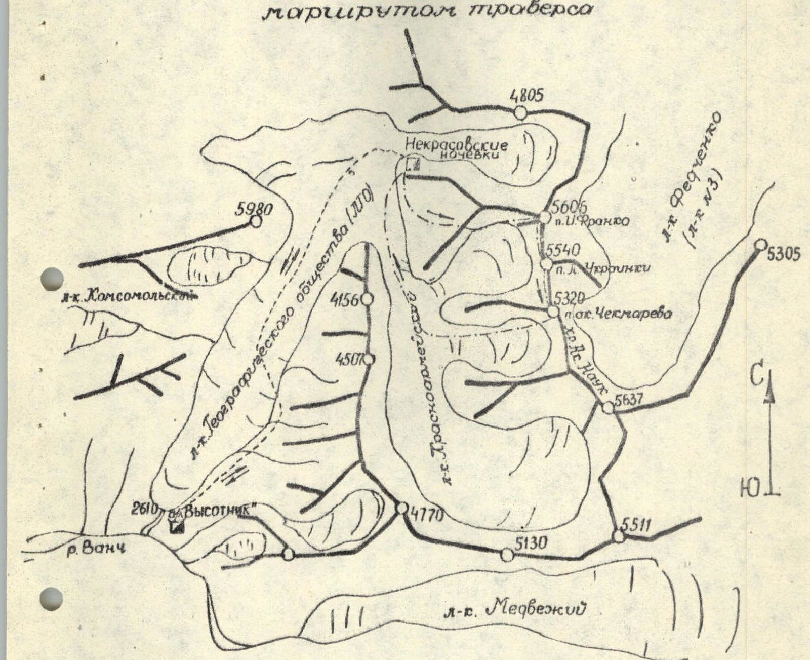
g) Approach to the Route - Traverse (see the attached map-scheme of the area):
- From the "Vysochnik" alpine camp, the path goes along a trail to the tongue of the GOG.
- Further, without going to its surface, movement continues along the left (orographic) randkluft of this glacier.
After 2-2.5 hours of walking, the trail transitions to the surface of the glacier, where it is lost among large stones. The "Nekrasovskie nochyovki" are located at the confluence of the GOG and the Krasnoarmeysky Glacier, behind a lateral moraine.
The entire path from the camp to these "nochyovki" takes 6-7 hours.
IV. Route Reconnaissance
The idea of traversing the specified peaks of the Academy of Sciences Range arose when reviewing a section of the ridge from the Komosomolsk Glacier, where the group was during a cycle of training ascents. The Komosomolsk Glacier (see the attached diagram) is a right (orographic) tributary of the GOG, and from its upper part, the Academy of Sciences Range is clearly visible, directly adjacent to Peak Komakademii. At the same time, a group of three dominant peaks is clearly distinguished on the Academy of Sciences Range:
- "5606"
- "5540"
- "5320"
The traverse, which appears to be a completely finished and logical route (photo 1).
For a more detailed reconnaissance of the planned route in the area of the Krasnoarmeysky Glacier, a reconnaissance group consisting of two people - A. Brynza and Yu. Ershov - was sent. During July 17-20, 1975, they conducted a reconnaissance of the area, ascending to the upper reaches of the Krasnoarmeysky Glacier and to the ridge separating the Krasnoarmeysky and GOG. The reconnaissance group clarified:
- approaches to the route,
- possible places for overnight stays and descents from the ridge,
- determined the tactical scheme of the traverse.
The data obtained by the reconnaissance group were reported to the training department of the "Vysochnik" alpine camp, from which permission to carry out the given traverse was obtained.
V. Description of the Completed Route
To facilitate the technical description of the completed traverse, the entire route is divided into 19 sections, indicated in photo 1. On the panoramic photograph of the ridge, sections R0-R1, R1-R2, and R2-R3 are not indicated, as they did not fit into the camera lens.
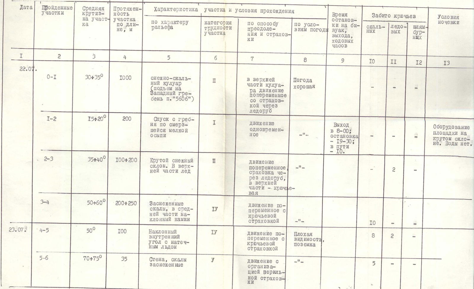
Below is a technical description of the route by sections, in accordance with the attached "Table of Main Characteristics of the Traverse Route."
July 22, 1975 (first day).
Section R0-R1.
From the "Nekrasovskie nochyovki," the path goes up the right (orographic) randkluft of the Krasnoarmeysky Glacier to the first snow couloir, which opens to the left along the direction of movement.
The further path along this couloir leads to the western edge of peak "5606." The steepness of the couloir in the upper part increases to 30-35°.
The ascent to the ridge along the couloir takes 2.5-3 hours.
Section R1-R2.
On the ridge, there is water and convenient closed platforms. From the ridge, there is a gentle descent along frozen small talus to a snowfield located under the rocks of the western counterfort of peak "5606."
Section R2-R3.
Along the snowfield, 100-120 m long, there is an exit under the rocks of the counterfort. Characteristics of the section:
- Average slope steepness: 35-40°
- In the upper part, the steepness increases
- There are sections of open ice
- On approaches to the rocks - insurance with the help of ice hooks
- Time taken to pass the section - 1 hour
Section R3-R4.
The first rocky section of the counterfort. The first two ropes are along rocks like "ram's foreheads." There is flow ice. By the third rope, the steepness reaches 70-75°. After the third rope, there are platforms where the entire group can gather.
Further, there is a 20 m chimney. Handholds need to be cleared of ice. Climbing is complex. The character of the counterfort after the chimney is the same as at the beginning of this section.
4-4.5 hours were spent on passing the section. Overnight stay on a large ledge, which needs to be cleared of stones, snow, and ice.
July 23, 1975 (second day).
Section R4-R5.
Directly from the overnight stay site, adhering to the left part of the counterfort, there is an inclined inner corner with icy walls. In the upper part of the corner, there is a platform. 2 hours were spent on passing the section.
Section R5-R6.
From the ledge above the inner corner, a wall begins with an average steepness of 70-75°. In places, the rocks are destroyed. There is a lot of ice. Thorough hook insurance. 1.5 hours were spent on passing the section.
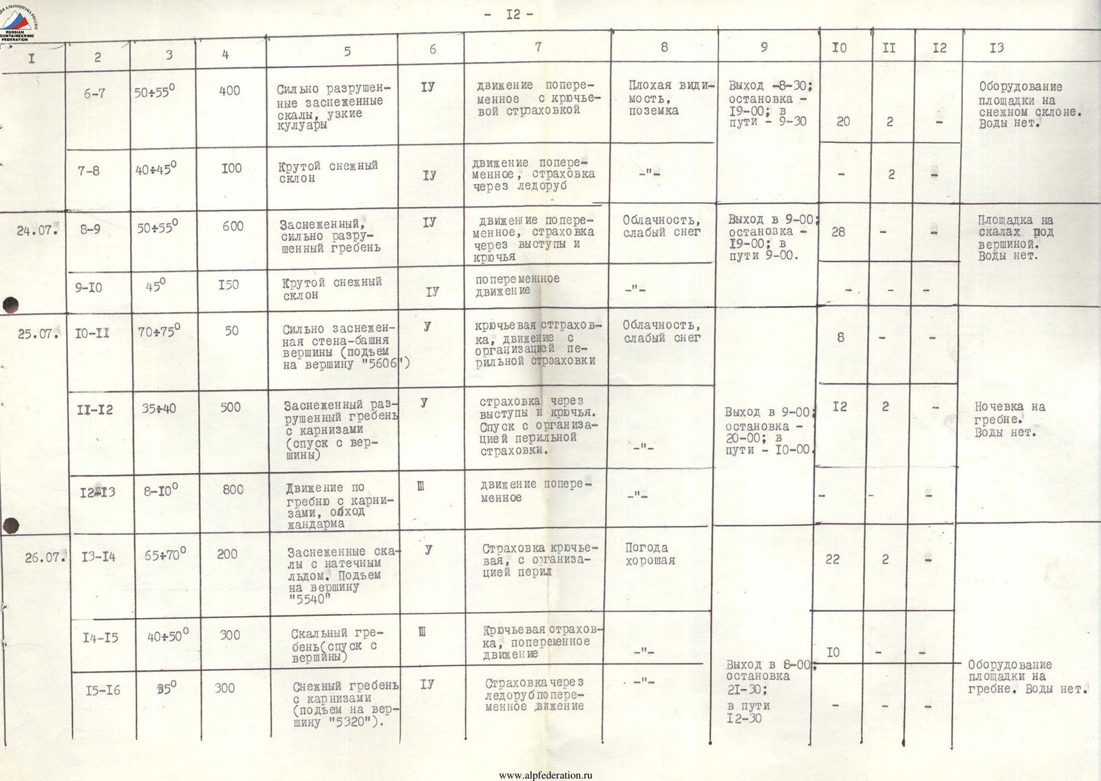
Section R6-R7.
Movement is along the center of the counterfort. The rocks are heavily destroyed. In places, climbing is very complex. Wall sections alternate with snow couloirs filled with ice and stones, along which the movement upwards occurs.
Passing the section took 4.0 hours.
Section R7-R8.
Along the left part (in the direction of movement) of the counterfort, above section R6-R7, there is a snow slope with a steepness of 40-45° (photo 2). In places, there are ice outcrops.
At the end of the section, there is an overnight stay. The platform is equipped on the bend of the snow slope. Time taken to pass the section - 2 hours.
July 24, 1975 (third day).
Section R8-R9.
Movement is along the counterfort. The rocks are heavily destroyed. Along the ascent path, there are short wall sections, 7-8 m long.
In many places, progress along the rocks is complicated by their heavy snow cover (photo 3).
7 hours were spent on passing the section.
Section R9-R10.
From the rocks, there is an exit to a steep snow slope (45°) 150 m long.
From the upper part of the snowfield, the tower of peak "5606" is visible (photo 3).
Overnight stay on rocks under the peak. 2 hours were spent on passing the section.
July 25, 1975 (fourth day).
Section R10-R11.
The ascent to the tower of peak "5606" goes along snow-covered steep rocks (photos 5, 6).
Features of the route:
- To the left on the rocks, there are overhanging cornices.
- The summit of peak "5606" is a small platform with dimensions 2.0×1.5 m.
- A cairn is built in the center of the platform.
Time taken to pass the section - 2 hours.
Section R11-R12.
The descent from the summit of "5606" is along a snow-covered, heavily destroyed ridge. To the left along the direction of movement:
- cornices,
- overhanging above the Fedchenko Glacier (photo 7).
The descent path in the upper part of peak "5606" is indicated in photo 8. (In the background of this photograph, Peak Komakademii is visible).
The time spent on descending from the summit of "5606" to the ridge was 3 hours.
Section R12-R13.
Movement is along the ridge of the Academy of Sciences Range towards peak "5540." The ridge is narrow and snow-covered. Thorough insurance for the person in front. In the center of the section, there is a gendarme, which is bypassed along the rocks to the right in the direction of movement (photo 9).
Overnight stay on the ridge under peak "5540" (photo 10). 4 hours were spent on passing the section.
July 26, 1975 (fifth day).
Section R13–R14.
The ascent to peak "5540" goes along steep, snow-covered rocks. Movement is complex in places. Handholds on the rocks need to be cleared of ice and snow.
- Hook and rope insurance! (photo 11).
4 hours were spent on passing the section. The summit of peak "5540" is a spacious snow platform (photo 12). A cairn is built on a rocky outcrop of the platform.
Section R14–R15.
The descent from the summit of "5540" is along rocks of medium complexity. The steepness of the ridge is 40–50°. In places, there is flow ice.
Time taken to pass the section - 2 hours.
Section R15–R16.
The ascent to peak "5320" goes along a steep snow ridge. Large cornices. Thorough insurance for the person in front (photo 13).
Before reaching the summit, a snow cornice is overcome. A cairn is built on a rocky outcrop of the snow platform of the summit. From the summit, a view opens up to the further continuation of the Academy of Sciences Range (photo 14).
Time taken to pass the section - 2 hours.
Sections R16–R17, R17–R18, and R18–R19.
The descent from the summit of "5320." First, it goes along the ridge of the Academy of Sciences Range to a lowering in the ridge and further along a snow couloir and glacier - a right tributary of the Krasnoarmeysky Glacier. A more detailed description of these sections is given in the table of main characteristics of the route.
The time taken to descend from the summit of "5320" to the "Nekrasovskie nochyovki" was 5 hours (including 1 hour of movement along the Krasnoarmeysky Glacier).
VI. Proposals for Evaluating the Completed Route
The group evaluates the completed traverse as a route of 5B category of difficulty. This difficulty is determined by:
- the large extent for which the section of the Academy of Sciences Range was traversed;
- the technical complexity of the route;
- the significant height of the peaks;
- the remoteness of the climbing area from populated areas.
The route traversed can be compared with the traverse routes included in the all-Union classification of peaks and having 5B category of difficulty:
- the Maria-Miraly - Chimtarga traverse,
- the Sagu - Dvuzubka traverse,
- as well as others that were previously passed by group members in the Pamir.
The mentioned routes are significantly inferior to the traversed route in terms of length, technical complexity, and peak heights.
At the same time, we consider it necessary to emphasize once again that the route was traversed in a poorly researched and hard-to-reach area of the Pamir.
VII. Proposals for Naming the Peaks
By the right of the first ascenders, the group proposes to give the peaks the following names:
- peak "5606" - the name of the famous Ukrainian poet I. Franko;
- peak "5540" - the name of the famous Ukrainian poetess L. Ukrainka;
- peak "5320" - the name of the Soviet metallurgist, academician A. P. Chekmarev, who died in 1975.
Below are brief biographical references to those whose names are given to the peaks.
Franko Ivan Yakovlevich (1856–1916) - a great Ukrainian writer, scientist, public figure, and revolutionary democrat.
He was the first to translate the works of Marx and Engels into Ukrainian and popularize their teachings among workers.
Franko created outstanding examples of artistic prose: "Udav", "Borislav smeyotsya", "Zakhar Berkut", and others. I. Franko had a significant influence on the further development of the social movement and culture of Ukraine. Franko's work became the property of all the peoples of our Motherland.
TABLE OF MAIN CHARACTERISTICS OF THE TRAVERSE ROUTE
- 12 -
 Lesya Ukrainka (pseudonym, real surname - Larisa Petrovna Kosach-Kvitko (1871–1913)) - an outstanding Ukrainian poetess. L. Ukrainka studied the works of Marx and Engels, and later Lenin, read Lenin's "Iskra," and translated into Ukrainian "The Communist Manifesto," "The Development of Socialism from Utopia to Science" by Engels, and others.
One of L. Ukrainka's outstanding works is the drama-fairy tale "Lesnaya pesnya," connected with the rich world of folk songs, tales, and beliefs, which is still successfully performed on the stages of many theaters in the USSR.
L. Ukrainka died in 1913 in Surami and was buried in Kiev.
Chekmarev Alexander Petrovich (1902–1975) - a Soviet scientist. Specialist in the field of rolling production, academician. Chekmarev's main works are devoted to the research and rationalization of rolling processes. Twice a laureate of the State Prize (1941, 1949).
For outstanding scientific achievements and the creation of the Dnepropetrovsk scientific school of rollmakers, A. P. Chekmarev was elected a full member of the Academy of Sciences of the USSR in 1972.
A. P. Chekmarev's pen belongs to more than 100 fundamental research works in the field of rolling production theory; his works have been translated into many languages of the world.
A. P. Chekmarev died in 1975 in Dnepropetrovsk, where he was buried.
- 13 —
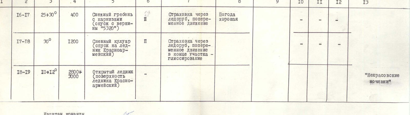
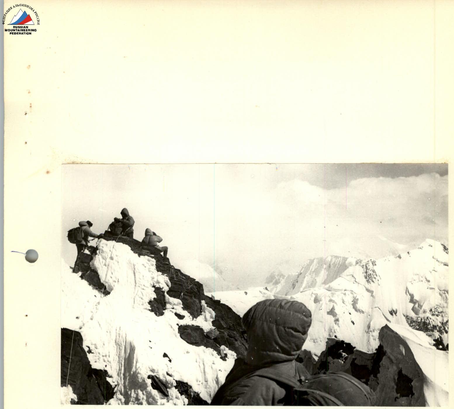
Photo 5, 6. On the summit of peak "5606".
Photo 12. On the summit of peak "5540".
Photo 13. Section R15–R16. On approaches to peak "5320".