Report
On the first ascent to Pik Tельмана (5970) via the Southwest ridge from the Bivachny glacier by the team of Ukr совет ДСО «СПАРТАК» consisting of:
- Komarov N.P. (team leader)
- Denisenko P.N.
- Ladnushkin V.M.
- Starodub O.V.
- Sulimovsky N.V.
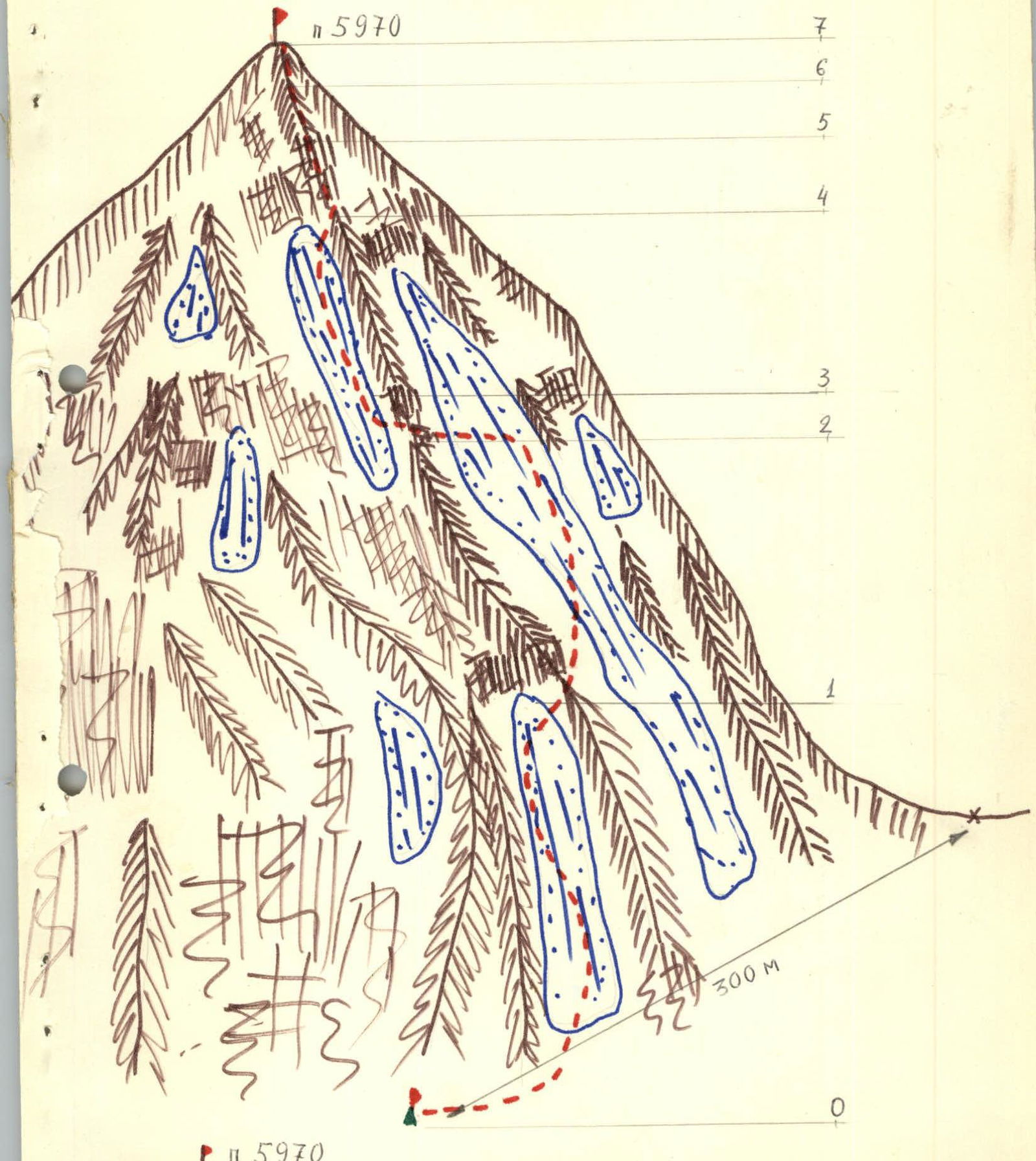

- Base camp
- Overnight locations
- Approach route
TABLE OF MAIN CHARACTERISTICS OF THE ASCENT ROUTE
| Section # | Designation | Average steepness in degrees | Length in meters | Terrain type | Difficulty | Condition | Weather conditions | Pitons |
|---|---|---|---|---|---|---|---|---|
| 0 | 35–40 | 300–350 | couloir, snow-ice | 2 | ||||
| 1 | 35–40 | 400–450 | scree slopes, ice couloir | 3 | ||||
| 2 | 60–70 | 20 | rock wall | 3 | destroyed | Snowfall | 3 | |
| 3 | 40–45 | 100 | ice couloir | 3 | ||||
| 4 | 60–70 | 50 | rock wall | 3 | destroyed | 6 cams | ||
| 5 | 30–35 | 10 | scree slopes | 1 | ||||
| 6 | 60–70 | 10 | rock wall | 3 | 1 cam |
Description of the approach to the route
From the base camp near the lake in the "pocket" of the Bivachny glacier, move along the glacier "pocket" past the lakes, crossing a large stream, to the river flowing from under the hanging glacier. Overnight stay on the other side of the river. 2.5–3 hours from the base camp. From the overnight location, exit to the shoulder to the right of the riverbed and then up the moraine, then to the right "pocket" of the glacier. Then exit to the glacier and further up the glacier under the saddle between p. 5970 and p. 5700. Overnight stay on the scree to the left of the glacier below the saddle, 300 m away.
Brief description of the route
From the overnight location, the route starts up an ice couloir 50 m above the tents. The couloir is steep, 35–40°, approximately 300 m long. Then:
- Traverse right across scree slopes
- Enter a large ice couloir running along the ridge
Up the couloir, past rock islands, 400 m. Exit the couloir to rock walls (pitons), then 2 rope lengths up through snow under the destroyed rocks of the pre-summit tower. Climb at grade 3 difficulty (2–3 pitons), cams. Through a rock couloir — smooth rocks, 20 m (2–3 pitons). Exit through the wall of the summit tower to the summit. From the overnight location at the start of the route to the summit — 7 hours. Descent via the ascent route.
Date: July 15, 1978 Time: 15:00
To the double gathering of the Alpine Sports Committee (jointly with the mountaineer from the USA) Consisting of Stoilov S.B. Lavrushkin V.I. Made an ascent to p. 5970 via the NE edge (first ascent) Weather is excellent. Greetings to the next climbers. Took the note. Yake Zoolgre and Bes. Reda and, Rukop. Blida.
Footnotes
-
Legend for the map: peak 5970; overnight location; path to the summit; saddle between peak 5970 and peak 5700. ↩