Climbing category — B/technical. Climbing region — Pamir. Darvaz Range. Peak, its height, route — p. 5970 (40 let Oktyabrya), height 5970 via N.E. spur. First ascent. Proposed category of difficulty — 4A. Route characteristics: height difference — 1250 m. Length of sections with 5–6 category of difficulty — 240 m. Average steepness — 50°. Pitons hammered: rock ( закладки ) — 50, ice — 44. Number of travel hours — 18. Number of nights and their characteristics — one, cut out in ice.
Surname, name, patronymic of the team leader, participants and their qualification:
- Efimov S. — MS
- Lavrukhin V. — MS
Team coach: — Efimov S.
Date of departure and return — July 14–15, 1978.
Dushanbe — 1978

Scheme of l. Bivachny area
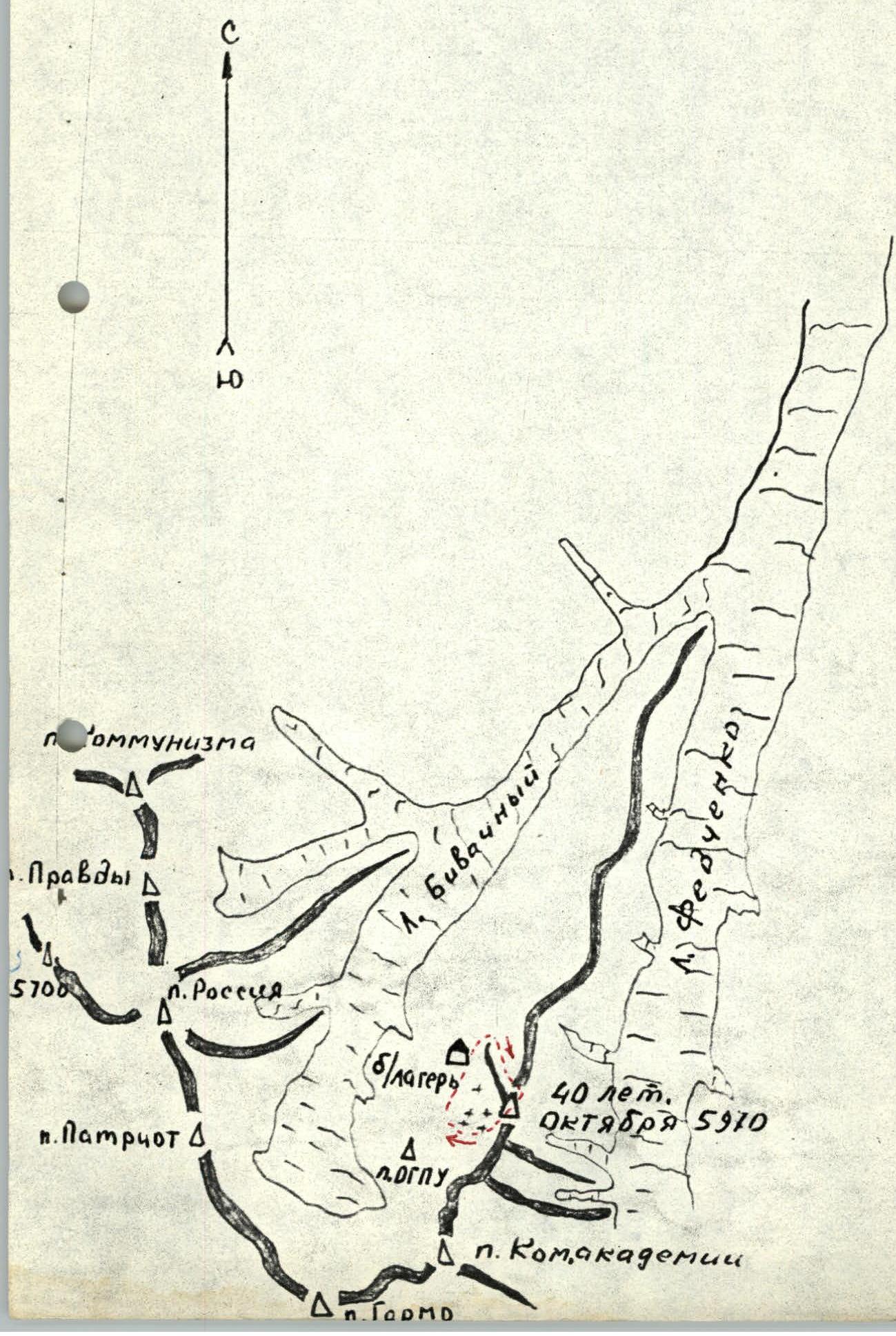

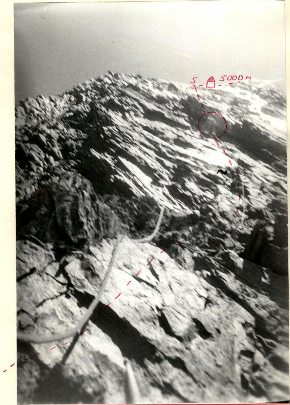
Photo of the profile
Approach to the route
From the bivouac under the western slopes of peak 5970 (right lateral moraine of l. Bivachny opposite the base of the screen — lower lake) down for 10 min to the stream flowing from the right (when facing the glacier) — from under the N.E. slopes of the peak.
Up the stream onto the glacier for 1 hour and across the glacier in the direction of the N.E. slopes of the peak. The glacier is calm.
20 min to the moraine bivouac sites under the central ice couloir with a bergschrund in the lower part.
The entire approach takes about 2 hours.
Brief explanation of the table
The route begins on the snowy (firn) slope of the central couloir (sec. R0–R1) to the bergschrund, simultaneous movement, steepness up to 40°. The upper edge of the bergschrund is 2 m higher than the lower one, we cross to the upper edge with belay. Further in the direction of the narrow gorge (ice) 4 × 40 m (sec. R1–R2) with alternate belay, steepness up to 45° along the rock spur. When moving, stay closer to the rocks (walk under their cover). Through the gorge, when the sun appears, stones fall — be careful! Before entering the gorge, move to the left (in the direction of travel) rock spur (sec. R2–R3) and along it simultaneously, using закладки , go 300 m until ice patches appear. Movement is careful, many loose rocks. From the ice patches, traversing the ice couloir at 45° (sec. R3–R4) to the left (in the direction of travel), we move to the central rock spur. The crossing is difficult on the front teeth of the crampons with belay. Along the rock spur 8 × 40 m in the direction of the ice pre-summit ridge (sec. R4–R5). Climbing is not difficult, belay — закладки (pitons), rocks are destroyed. The bivouac is organized at an altitude of 5000 m on the last rock outcrops; a good platform is cut out in the ice. From the bivouac up the slope of the ice ridge 4 × 40 m, 50° (sec. R5–R6), climbing is not difficult. At the end of this section, the slope steepness increases to 55°, ice is firm. Climbing is difficult on the front teeth of crampons 6 × 40 m (sec. R6–R7), belay via ice screws. Along the ice slope, we approach the rock outcrops (sec. R7–R8). Bypassing the rocks to the right (in the direction of travel) 2 × 40 m, 50°. The rocks are clogged with snow, which complicates their passage, belay — закладки. From the rocks (sec. R8–R9) along the ice slope 40° under the bergschrund 2 × 40 m. The bergschrund is narrow, up to 30–50 cm, the upper edge hangs up to 1 m, it is passed in its left part. From the bergschrund (sec. R9–R10) 120 m across the firn to the rock ridge. Along the ridge 250 m simultaneously to the summit (sec. R10–R11). From the summit, descent along the scree N.W. slope (to the left in the direction of travel) 1500–2000 m to the glacier flowing into l. Bivachny, 5 km above the base camp. Along the right lateral moraine along the glacier "Bivachny" to the base camp. Descent directly to the base camp through the N.W. ridge adjacent to the summit is possible. The descent route is approximately 3A, 3B category of difficulty. Descent from the summit via the first option takes 4–5 hours. Table of main characteristics of the route to peak 5970 (40 let Oktyabrya) via N.E. spur — 4A. Table compiled by: V. Lavrukhin
| Date | Designation | Steepness in degrees | Length in m | Terrain characteristics | Difficulty | Condition | Weather conditions | Pitons: rock | Pitons: ice | Pitons: шл. |
|---|---|---|---|---|---|---|---|---|---|---|
| July 14 | R0–R1 | 40 | 200 | firn slope | 1 | firm firn | good | simultaneously | ||
| —//— | R1–R2 | 45 | 160 | ice slope | 4 | ice, rockfall | —//— | — | 16 | — |
| —//— | R2–R3 | 45 | 300 | rock slope | 2, 3 | destroyed | —//— | 10 | — | — |
| —//— | R3–R4 | 45 | 80 | ice couloir | 4 | ice | —//— | — | 8 | — |
| —//— | R4–R5 | 60 | 320 | rock spur | 3, 4 | destroyed | —//— | 30 | — | — |
| July 15 | R5–R6 | 50 | 160 | ice slope | 3, 4 | porous ice | —//— | — | 8 | — |
| —//— | R6–R7 | 55 | 240 | —//— | 5 | ice | —//— | — | 12 | — |
| —//— | R7–R8 | 50 | 80 | rock spur | 4 | rocks clogged with snow | —//— | 8 | — | — |
| —//— | R8–R9 | 45 | 80 | ice slope | 3 | porous ice, snow | —//— | simultaneously (rock outcrops) | ||
| —//— | R9–R10 | 30 | 120 | snowy slope | 2 | — | —//— | simultaneously | ||
| —//— | R10–R11 | 20 | 250 | rock ridge | 3 | destroyed | —//— | simultaneously (rock outcrops) |
section 4–5