Upper Reaches of the Fedchenko Glacier
"Description of the First Ascent to Peak Sент-Экзюпери (6063 m), Category 4B difficulty via the North Ridge". Protocol No. 427 dated January 18, 1977. Classify as Category 4A difficulty. First ascent credited to the group.
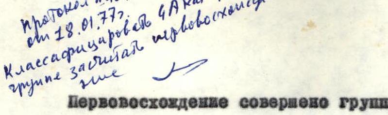
The first ascent was made by a group of climbers from the Chelyabinsk Regional Council of the "Trud" Sports Society on August 27, 1976.
Group Composition
Leader — K.N. Veselov — Candidate Master of Sports
Members:
- A.V. Abramov — 1st sports category
- G.L. Derovnoy — 2nd sports category
- G.S. Yazovskikh — Candidate Master of Sports
Release Officer — V.G. Tarkhanov — Master of Sports in mountaineering, senior instructor.
Description compiled by:
- K. Veselov
- A. Abramov
- G. Yazovskikh
Chelyabinsk Regional Mountaineering Federation. 1976.
Introduction
Peak "6063 m" is located in the southern part of the mountain range of the Academy of Sciences, bounded by the Fedchenko, Abdugagor, and Medvezhiy glaciers.
This peak is adjacent to the Abdugagor II pass from the north and has the form of a pointed pyramid.
The summit attracts the attention of all climbers ascending through the Abdugagor II pass to the Fedchenko glacier due to its beautiful shape. According to our information, since the time of the first expedition that explored the route to the Fedchenko glacier via the Abdugagor II pass (1965, group leader S.M. Lukomsky), this peak has been named Peak Sент-Экзюпери.
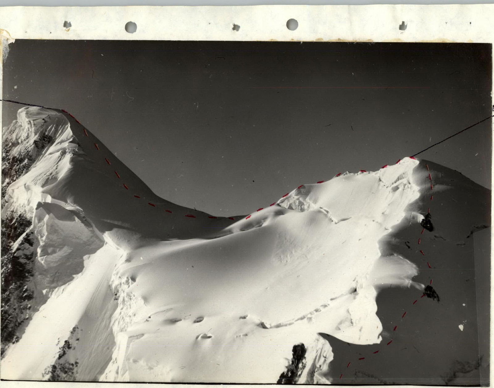
To the north of Peak Sент-Экзюпери, a ridge runs with a series of unpronounced unnamed peaks, forming an almost closed C-shaped contour. The entrance to the depths of this contour (cirque) is between the peaks of Sент-Экзюпери to the left and 5930 m to the right. The "gates" represent a glacier serac that drops from the ridge of Peak Sент-Экзюпери.
The slopes of the cirque are steep, with cornices on the ridge. Rocky sections of the ridge are prone to rockfall. The most logical and safe ascent route to the ridge follows the eastern rib of the second unnamed peak from Peak Sент-Экзюпери.
General Route Description
The route consists of the following main stages:
- R0–R1 Approach from the Abdugagor II pass to the glacier serac;
- R1–R2 Ascent via the glacier serac.
- R2–R3 Exit via the rib to the north ridge of Peak Sент-Экзюпери.
- R3–R4 Traverse the ridge to the saddle between the Unnamed peak and Peak Sент-Экзюпери.
- R4–R5 Ascent to the summit. Descent via the ascent route.
Technical Route Description
Departure from the base camp on the Abdugagor II pass at 8:00. The path from the pass to the start of the route goes north through the "gates" between the peaks of Sент-Экзюпери and 5930 m, then west into the C-shaped ridge cirque (section R0–R1).
We pass through the "gates" and stop under the glacier serac starting in the northern part of the cirque. The serac is broken by large crevasses. Closer to the rib descending to the east, on the second unnamed peak from Sент-Экзюпери of the C-shaped ridge, the glacier is less broken. We plan our ascent route through the serac here. We put on crampons. We rope up. We cross crevasses via snow bridges with careful belaying and ascend to the northern part of the cirque (section R1–R2). Time — 12:10. (The entire serac is approximately 300 m). From the northern part of the cirque, we ascend south via snow slopes with a gradient of 35–40° to the rib of the 2nd Unnamed peak. Belay via ice axe.
On the northern slope of the rib, the snow is loose, with small cornices hanging. We cross the bergschrund via a bridge at the lowest part of the rib. All attempts to cross it higher up the rib were unsuccessful.
The first 60 meters of this snow-ice rib are traversed in "three steps," chopping steps in the snow. The slope gradient is about 40°. Then the slope gradient increases to 50–55°, and the snow cover decreases to 50 cm–10 cm. The snow is soft and does not hold. Belay is via ice screws. The entire slope length is about 300 m (section R2–R3). We leave the first control cairn on the Unnamed peak. Time 18:30.
We descend along the ridge to the south and organize a comfortable bivouac in a depression. After the bivouac, we depart for the route at 9:00. The ridge (section R3–R4) has large cornices dropping to the east towards the Fedchenko glacier. On the ridge, there are snow-ice inclines with gradients up to 50–60° and lengths from 20 to 60 m. Belaying on the inclines is via ice axes and screws. The descent from the Unnamed peak to the saddle towards Sент-Экзюпери is a snow-ice slope with a gradient of 30–40° and numerous small closed crevasses. The slope length is about 200 m. Belay via ice axe.
From the saddle, we begin the ascent to the summit of Sент-Экзюпери via a snow-ice slope (section R4–R5) with a gradient of about 45°. In the upper part, the slope gradient increases to 50–55°. The slope length is approximately 400 m. The snow cover at the start of the ascent is 30–40 cm. The upper part of the slope is icy. Belay via ice screws.
The summit of Sент-Экзюпери consists of three peaks in a line from west to east. The highest is the westernmost.
On the summit, we did not find a control cairn with a note or any other signs of previous human presence.
On the western summit, on the rocky outcrop about 10–15 m below the highest point, we built a control cairn with a note. Time 15:00. The descent from the summit is strictly via the ascent route.
Main Characteristics Table
The route is snow-ice. The ascent to the ridge via the rib is logical, as rockfall and ice chunks fall from the left and right throughout the daylight hours.
The approximate route length is 2.5 km, including approximately 600 m of difficult sections.
The average gradient of the difficult sections is about 40–45°. Time of departure for the route from the Abdugagor II pass — 8:00 on August 26, 1976.
Time of reaching the summit — 15:00 on August 27, 1976. Time of return to the camp on the Abdugagor II pass — 12:00 on August 28, 1976.
Total climbing hours — 24 hours.
Route Recommendations
- A group of four should have the following equipment:
- Sleeping bags — 4 pieces;
- Tent — 1;
- Main rope — 2 × 40 m;
- Crampons — 4 pairs;
- Ice axe (ice hammer) — 2 pieces;
- Ice screws — 10 pieces.
- Bivouac can only be organized on the ridge.
- Descent from the summit is strictly via the ascent route.
Proposals for Route Evaluation
Considering the route's altitude (5300–6053 m) and the length of difficult ice sections according to the "Methodology for Determining Route Difficulty Categories" by A.F. Naumov in the book "Karaugom, Digoria, Tsey", Moscow, 1976, we propose evaluating our route as Category 4B difficulty.
Profile development of the route
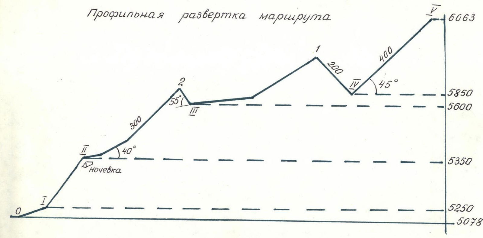
Table of main route characteristics.
| Section | Average gradient, ° | Length, m | Terrain characteristics | Technical difficulty | Method of overcoming and belaying | Weather conditions | Pitons used. Rock | Ice | Notes |
|---|---|---|---|---|---|---|---|---|---|
| R2–R3 | 40 | 300 | Snow, ice, cornices | Average | Steps, ice axe, ice screws | Good | — | 10 | |
| R3–R4 | 55 | 140 | Snow, ice, cornices | Above average | Steps, ice axe, ice screws | Good | — | 8 | |
| R4–R5 | 45 | 400 | Snow, ice | Above average | Steps, ice axe, ice screws | Good | — | 25 |
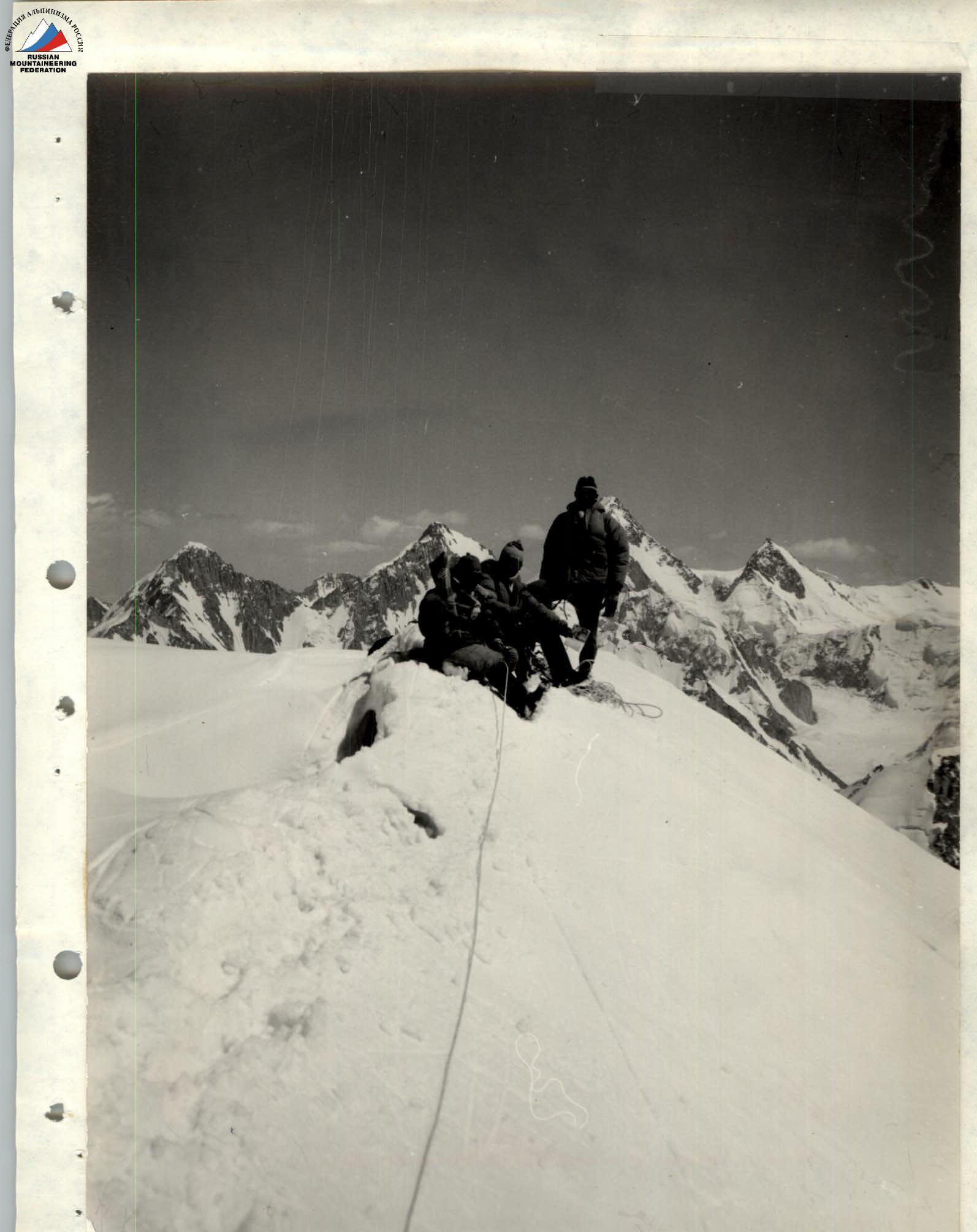
On the summit of Peak 6063 m (Sент-Экзюпери)