416
Description
Ascent route to Sandal Peak (6150 m) via the NE ridge from Maly Tanymas Glacier (first ascent)
Group composition:
- Volynets G.I. — leader, Candidate for Master of Sports.
- Mikhailov A.A. — participant, 1st category.
- Efimov S.D. — participant, 1st category.
- Yakovlev G.S. — participant, 1st category.
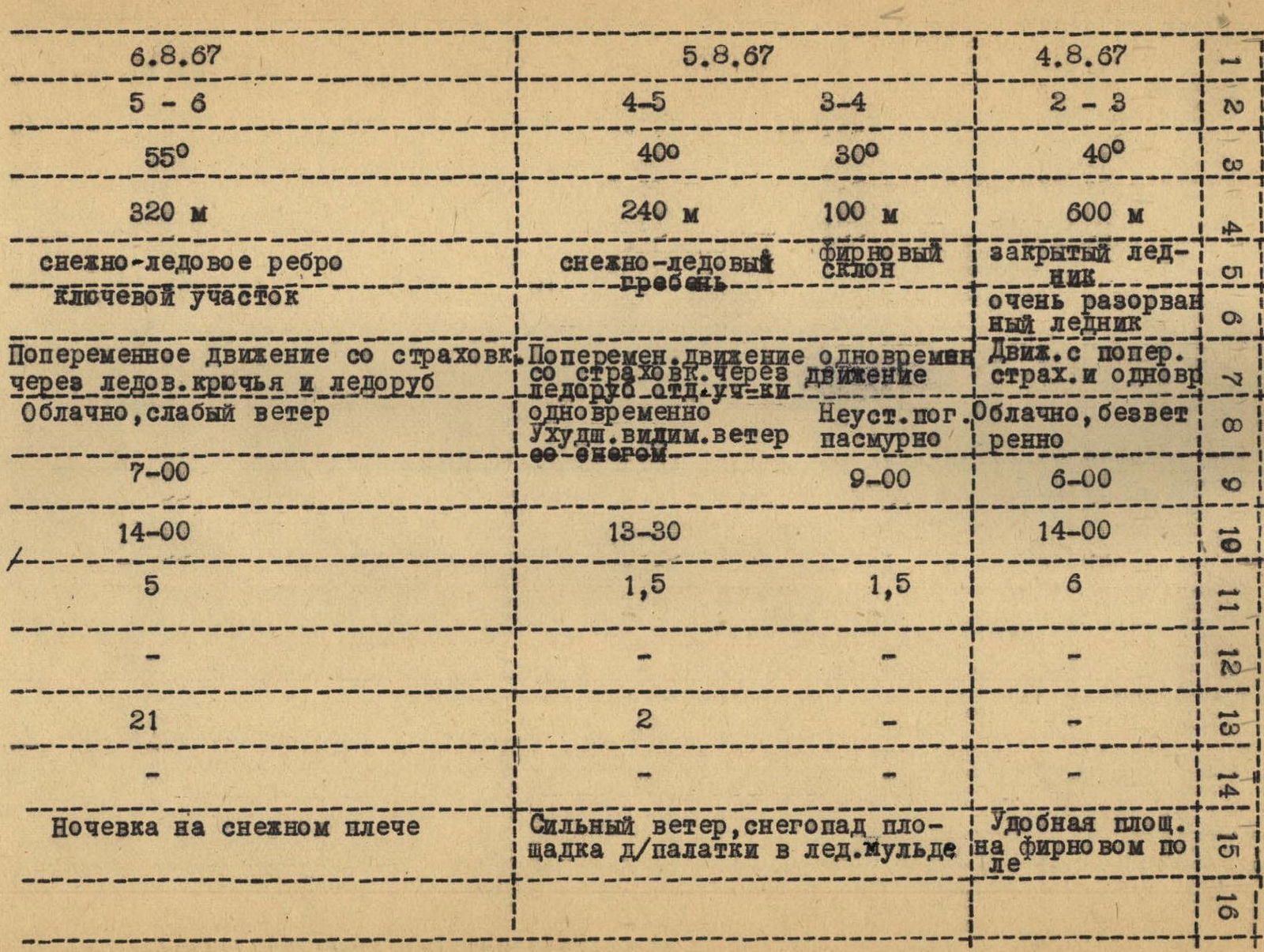
Route timeline
The route was completed from August 3 to 8, 1967, in 45 hours of climbing time by a sports group from the Sverdlovsk Pamir Expedition, starting from the base camp at 3450 m on Maly Tanymas Glacier.
Summary data on the route
Route character: snow and ice. Elevation gain: 2700 m.
Including most difficult sections:
320 m (5/6),
150 m (7/8).
Route steepness: 40–50°. Including most difficult sections: 70°.
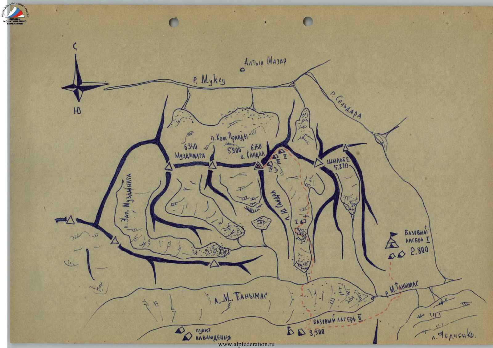
Sandal Peak is located in the Academy of Sciences Range within the Mazar Alps system, between the peaks of Shilbe and Komsomolskaya Pravda. The peak's elevation is 6150 m.
The climbers were part of the Sverdlovsk Expedition, with the base camp at 2800 m situated at the confluence of Fedchenko Glacier and the valley of Maly Tanymas Glacier, on the bank of the river with the same name. This location was also used as a base camp by the Tajik-Pamir Expedition (TPE) in 1933.
Helicopters were used to transport gear and participants from Daraut-Kurgan to the main base camp.
The ascent to Sandal Peak was made from an intermediate base camp at 3450 m on Maly Tanymas Glacier. The glacier is located to the left (orographically) of Fedchenko Glacier's tongue but does not reach it by 1+1.5 km. The 3450 m camp was on the right (orographically) lateral moraine of Maly Tanymas Glacier, opposite the confluence of Yuzhny Sandal Glacier, which led to the ascent route. (A photo of Yuzhny Sandal Glacier was taken from the slopes of the valley below the intermediate base camp).
The necessary gear for the ascent was carried by the participants themselves to the 3450 m camp, which was 4–5 hours away from the main base camp at 2800 m. After crossing the Maly Tanymas River, the route proceeded along the riverbed and then up steep, grassy slopes and cemented scree.
The Maly Tanymas Glacier area had not been previously visited by climbers, and the participants did not have access to large-scale topographic documentation. As a result of the expedition, key peaks were ascended, and a detailed map of the Maly Tanymas Glacier basin was created.
Sandal Peak is visible from both Altyn-Mazar and Maly Tanymas Glacier. The entire Yuzhny Sandal Glacier, or rather the icefall, consists of three steps. The first two steps are the most broken part of the icefall.

Two days before starting the route, the group conducted a reconnaissance of the icefall to determine its passability and develop a technical plan for the ascent. During the reconnaissance:
- the first step of the icefall was traversed;
- the most logical and safe path through the second step was identified.
A tactical plan for the ascent was then developed, as reflected in the route sheet. Some adjustments were made to this plan during the ascent due to weather conditions and ice-snow conditions.
The order of route progression was as follows:
Day 1: August 3, 5:00 AM
- The group departed from the camp (3450 m).
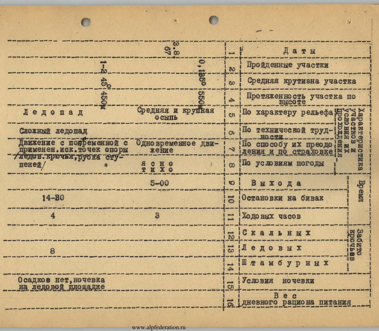
- After leaving the intermediate base camp of the Sverdlovsk Expedition, it was necessary to cross Maly Tanymas Glacier, the surface of which in this area is a jumble of seracs — both pure ice and those covered with scree. Crossing the glacier took 1.5 hours.
First section of the route
- The first step of the icefall is traversed on the left (orographically) along the lateral moraine.
- In the upper part of the first step, the path becomes rockfall-prone as the rock walls of Shilbe Peak overhang from the right.
- Therefore, after 1–1.5 hours of movement, it was necessary to rope up and put on crampons.
(End of the first section)
- Further movement towards the base of the second step occurs across the glacier from right to left.
- The path crosses several snow-ice crevices with snow bridges, which need to be traversed very cautiously with reliable ice axe belay.
- When ascending from the last crevice, a ladder made of ice axes was used, and fixed ropes were established.
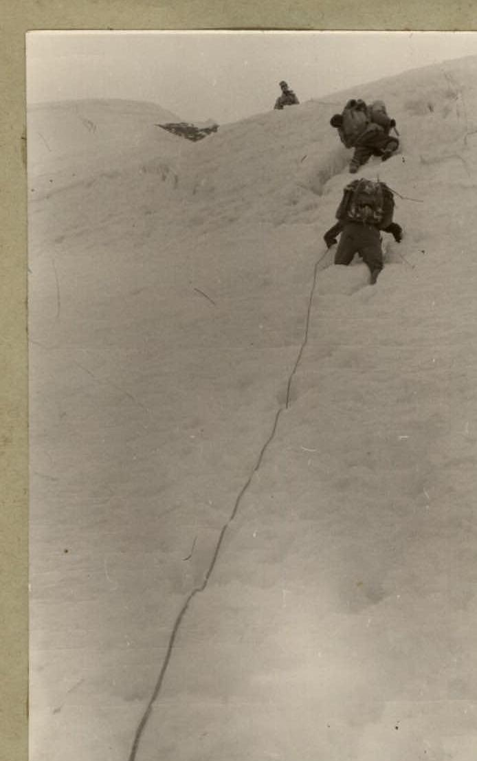
The second step of the icefall is the most serious part of the ascent and represents a chaotic jumble of seracs, some reaching 15–20 m in height. Between the seracs, there are numerous crevices. Additionally, the overall steepness of this part of the icefall reaches 40–45°. Therefore, movement requires maximum caution. Climbing is done with running belays, anchoring through bends or ice outcrops. Often, climbers had to move on the front points of their crampons, cut steps — in general, employing the full arsenal of ice climbing techniques.
The overall movement through the second step is from right to left and very close to the rock walls of Sandal Peak, which drop sheer to the icefall. The glacier then becomes less steep. Here, after 7 hours of climbing at an altitude of 4450 m, the first night's bivouac was established.
It is necessary to start as early as possible on the first day, as movement becomes dangerous in the second half of the day due to rockfall and falling ice blocks. During the ascent of the second step, the group marked the route. On the first day, 8 ice screws were placed.
Day II. Departure from the bivouac at 6:00 AM.
The third section begins with the ascent to the third step of the icefall. This step has a less steep overall incline, but here too, it is constantly necessary to:
- bypass wide crevices,
- cross over snow bridges.
The third step is a broken, closed glacier. When moving, it is necessary to:
- probe the path with an ice axe when crossing crevices,
- belay through the ice axe.
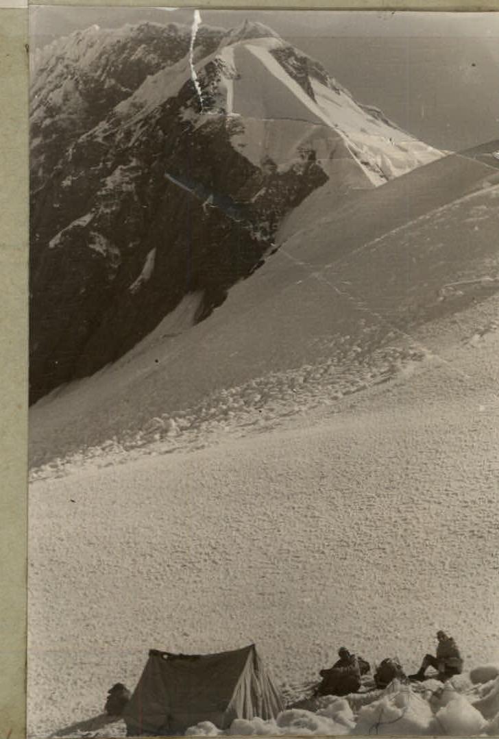
In the upper part of the third step, crampons can be removed. After 5–6 hours of climbing — exit to the saddle between Shilbe and Sandal Peaks. It is better to establish a bivouac under the saddle, as finding a suitable spot on the ridge is more challenging and there is strong wind. The altitude of the bivouac is 5050 m.
Day III. Weather deteriorated during the night. In the morning, due to fog, it was impossible to continue the route. Therefore, the group departed from the bivouac on August 5 only at 9:00 AM, under overcast and unstable weather conditions. On this day, sections 4 and 5 of the route were completed.
The ascent to the saddle (1–1.5 hours) occurs along snow slopes of medium steepness. Climbers can move simultaneously.
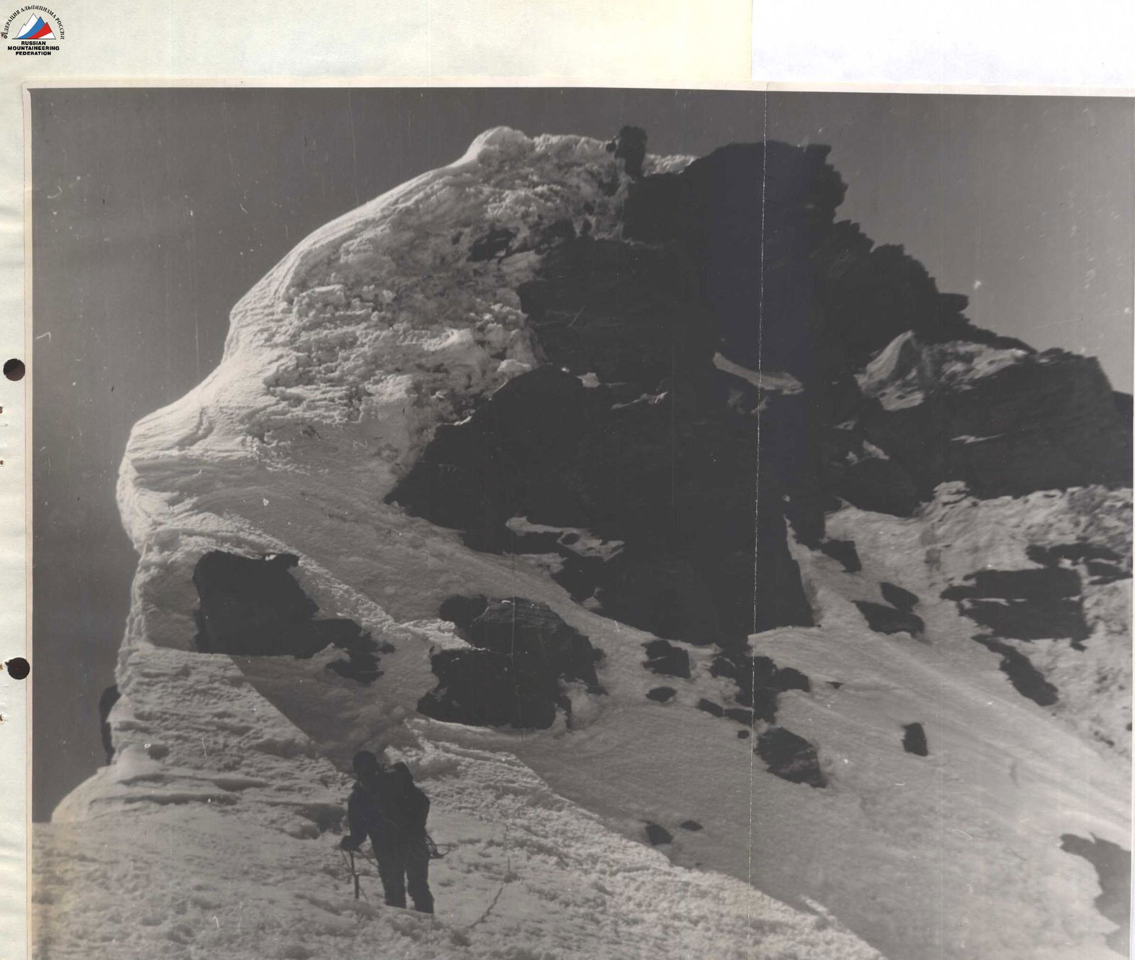
From the saddle begins the ascent to the ridge. To the right, there are significant cornices. Movement initially goes along two snow ridges, which drop steeply to the left and end in wide crevices. It is necessary to move with maximum caution to avoid either causing the cornices to collapse or triggering an avalanche.
The first snow ascent ends with a 10-meter ice wall. Overcoming the 5th section takes 1.5–2 hours. The snow is very deep. The ridge leads to a significant ice cornice, access to which is blocked by an almost sheer snow-ice wall 25–30 m high.
Here, at an altitude of 5390 m, on a convenient snow platform, a third bivouac was established at 1:30 PM, as continuing the ascent due to snowfall with wind became impossible. On this day, 2 ice screws were placed.
Day IV. On August 6, the group departed from the bivouac at 7:00 AM. On the same day, the 6th section was traversed.
The snow-ice wall of the cornice is bypassed on the left along a steep ice slope with a steepness of 55–60° (up to 70° in the upper part) and a length of 100 m. Upon exiting to the ice slope from the bivouac, belay through an ice axe can be organized.
On this section, movement is on the front points of crampons with the placement of ice screws. Further — exit to a pronounced snow-ice ridge.
In the lower part of the ridge, there are about 40 m of ice, then the ice transitions into firn, into which an ice axe can be driven, but movement in the upper part is still done in crampons, as tricouni boots do not hold, and the steepness of the ridge reaches 60°.
The ridge is 250–300 m long and leads to a cornice, which is best traversed by cutting steps in the left part. From the snow ridge, it is necessary to move left under the cornice for 30 m.
After overcoming the cornice — a fourth bivouac on the pre-summit shoulder at an altitude of 5710 m. On this day, 21 ice screws were placed.
Day V. On August 7, the group departed from the bivouac at 6:00 AM. On this day, sections R7, R8, R9, and R10 were traversed.
Section R7 represents a series of broken snow-ice ascents leading to the bergschrund. Crevices are crossed over snow bridges with ice axe belay. Movement is in crampons.
Further — along the bergschrund, approach under the pre-summit rocks. The ascent to the rocks from the bergschrund is along a steep (65°) snow-ice slope. Steep, snowy rocks of medium difficulty are overcome with piton belay. The ascent along the rocks leads to a cornice on the pre-summit ridge. The cornice is traversed with the help of a ladder made of ice axes.
After exiting to the snowy pre-summit ridge, it takes 30–40 minutes of simultaneous movement to reach the summit. By 3:00 PM, the group descended along the ascent route to a bivouac at an altitude of 5710 m. This was the fifth bivouac. On this day, 14 rock pitons and 15 ice screws were placed.
Day VI. On August 8, the group departed from the 5710 m bivouac at 5:00 AM and by 5:00 PM descended along the ascent route to the intermediate base camp of the Sverdlovsk Expedition at an altitude of 3450 m.
The group rated the route as category 4B difficulty.
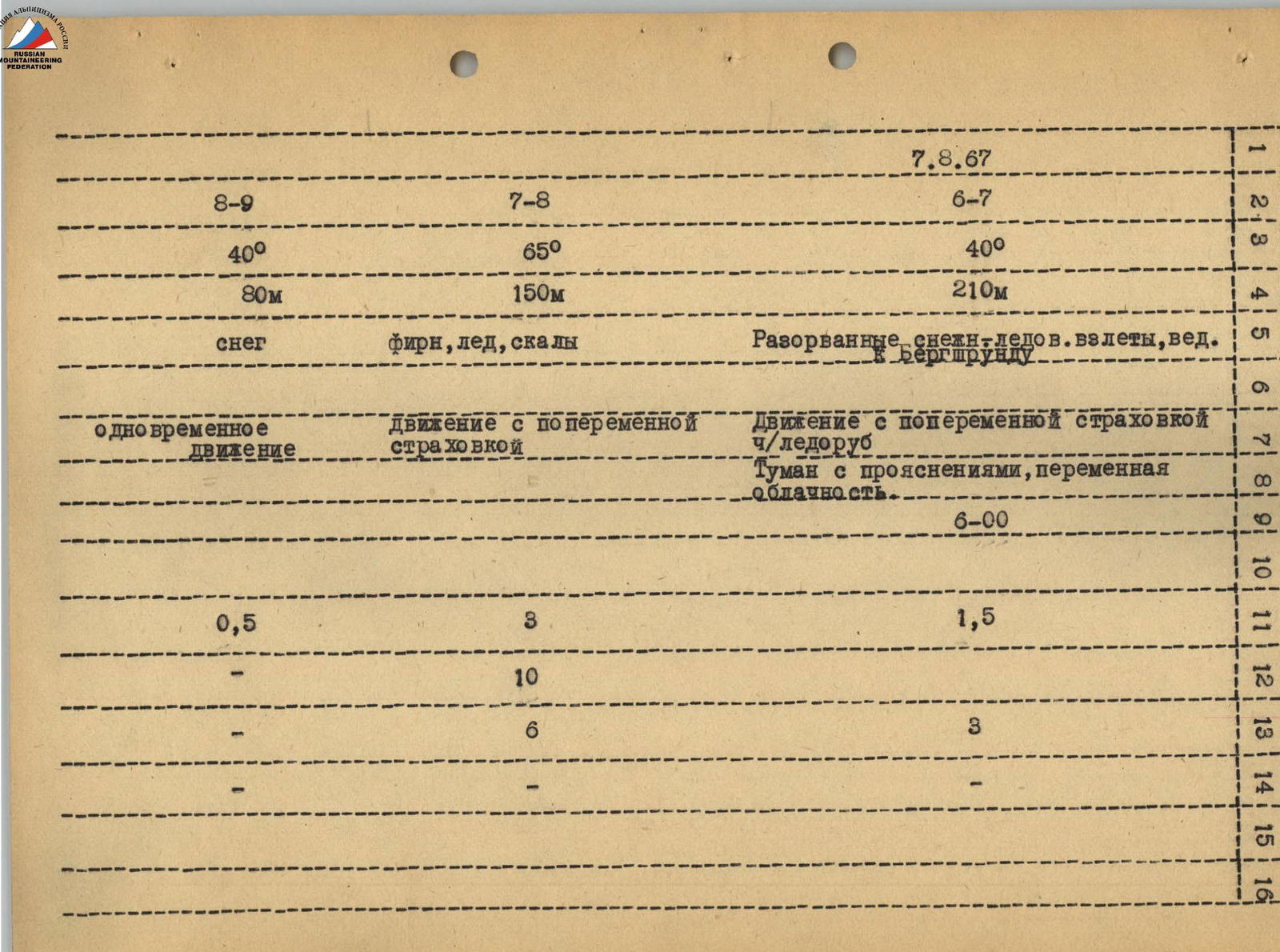
| R8–R9 | R7–R8 | R6–R7 | 5 |
|---|---|---|---|
| 40° | 65° | 40° | 20 |
| 80 m | 150 m | 210 m | 1 |
| snow | firn, ice, rocks | Broken snow-ice ascents leading to bergschrund | C |
| simultaneous movement | movement with running belay | movement with running belay through ice axe | 3 |
| 3 | |||
| Fog with clearings, variable cloudiness | 0 | ||
| 0.5 h | 3 h | 1.5 h | 2 |
| – | 10 | – | 5 |
| – | 6 | 3 | 2 |
| – | – | – | 1 |