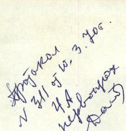
Ascent to Peak Sandal (6150 m)
via the northern edge from the Maly Tanymas valley (Central Pamir, Mazarskiye Alps)
Expedition of the Odessa Regional Council of the "Avangard" Sports Society
Climb leader: Stecenko N.A.
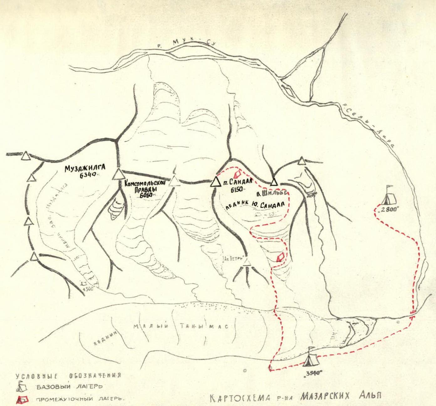
Brief geographical, geological and climatic characteristics of the Mazarskiye Alps region
Communication routes
The Mazarskiye Alps are a group of peaks at the northern end of the Academy of Sciences Range in the Central Pamir.
To the east and north, the Mazarskiye Alps are bounded by the valleys of the Sel-Dara and Muk-Su rivers, respectively, and to the south by the glacier and the river of the same name, Maly Tanymas, which flows into the Sel-Dara river, and the tongue of the Fedchenko Glacier.
To the west, the Mazarskiye Alps are connected through a significant depression in the ridge with the peaks of the Academy of Sciences Range, the upper reaches of the Maly Tanymas and Ayu-Dzhilga glaciers.
The peaks of the Mazarskiye Alps include: Shilbe (5870 m), Sandal (6150 m), Kommunist Pravda Peak (6060 m), and Muzdzhilga (6340 m).
The rocks forming the peaks are granite and schist with very beautiful crystals of pyrite.
The rocky slopes are destroyed, with alternating destroyed and monolithic sections on the ridges. Snow cover: — from the north — powdery, deep; — from the south — "kalgaspor" type on an ice base.
The entire area is characterized by a large number of snow cornices of various shapes and sizes. Routes to the peaks: — mostly snow and ice; — combined — typical for southern slopes.
The location of the Mazarskiye Alps on the edge of the Central Pamir highlands, at the confluence of the Muk-Su river, determines the region's feature — a large height difference from the foot to the top.
For example, for Peak Sandal, it is 3540 m from the north and 2840 m from the south.
The most favorable weather conditions are from July 15-20 to the beginning of September. Warm and clear weather allows the use of alpine tents and footwear.
Sporting characteristics of Peak Sandal
The first ascent to Peak Sandal was made in 1955 by a group of climbers from the MTS DSO "Spartak" led by V.A. Kizel. The ascent route included a climb up the northern slope (from Muk-Su) to the saddle between the peaks Shilbe and Sandal, and then along the main ridge of the Academy of Sciences Range to the summit. The route is classified as 5B category of difficulty.
Card P-144. Scale 1:100000. The main technically challenging part of the route is located on the section from the saddle to the summit.
The route of the first ascenders was repeated in 1966 by a group from the Sverdlovsk expedition, and in 1967 it was part of the traverse Shilbe – Muzdzhilga, carried out by climbers from Sverdlovsk during the USSR championship.
In 1969, in preparation for the traverse Sandal–Muzdzhilga with an ascent to Sandal via the southern ridge, a group of participants from the Odessa expedition, including M.S. Simonenko V.K., CMS Melnik V.N., CMS Yaroshenko V.N., and CMS Zimnitsky E.P., made an exit to the saddle between the peaks Shilbe–Sandal from the south via the heavily crevassed South Sandal glacier and then followed the main part of the classified route up to the pre-summit ridge (the ascent was stopped due to bad weather).
This attempt allowed the participants of the Odessa "Avangard" DSO expedition to have a complete understanding of the route's nature, and to develop a tactical plan for ascending Peak Sandal via the northern ridge, with an approach from the south via the South Sandal glacier.
General characteristics of the route and tactical ascent plan
The route to Peak Sandal via the South Sandal glacier can be broken down into main sections:
a) Base camp 3500 – saddle between Sandal and Shilbe. This section includes: — crossing the Maly Tanymas glacier (2–2.5 hours); — overcoming the South Sandal glacier (14–15 walking hours) — due to the exceptionally crevassed state of the glacier in 1969.
b) Saddle – pre-summit and summit. The route from the saddle to the pre-summit represents a snow and ice ridge with steep ice sections and a prominent giant gendarme. From the gendarme (ice and rock wall), it leads to the pre-summit ridge. The pre-summit ridge is relatively gentle, with protruding sharp rocky gendarmes, like "feathers," and snow cornices hanging towards the South Sandal glacier. At the junction of the main ridge and the pre-summit ridge (the summit of Peak Sandal is south of the main ridge connecting the peaks Shilbe – Muzdzhilga), there is a prominent rocky gendarme.
The tactical ascent plan provided for the following movement schedule:
| I day | – 3500 – lateral moraine of the South Sandal glacier. |
|---|---|
| II day | – Lateral moraine of the South Sandal glacier – saddle (very tense day – 14–15 hours). |
| III day | – Rest, preparation. |
| IV day | – Saddle – ice ridge under the giant gendarme. |
| V day | – Ridge – saddle behind the gendarme. |
| VI day | – Saddle behind the gendarme – summit – saddle. |
| VII day | – Saddle – saddle. |
| VIII day | – Saddle – base camp 3500. |
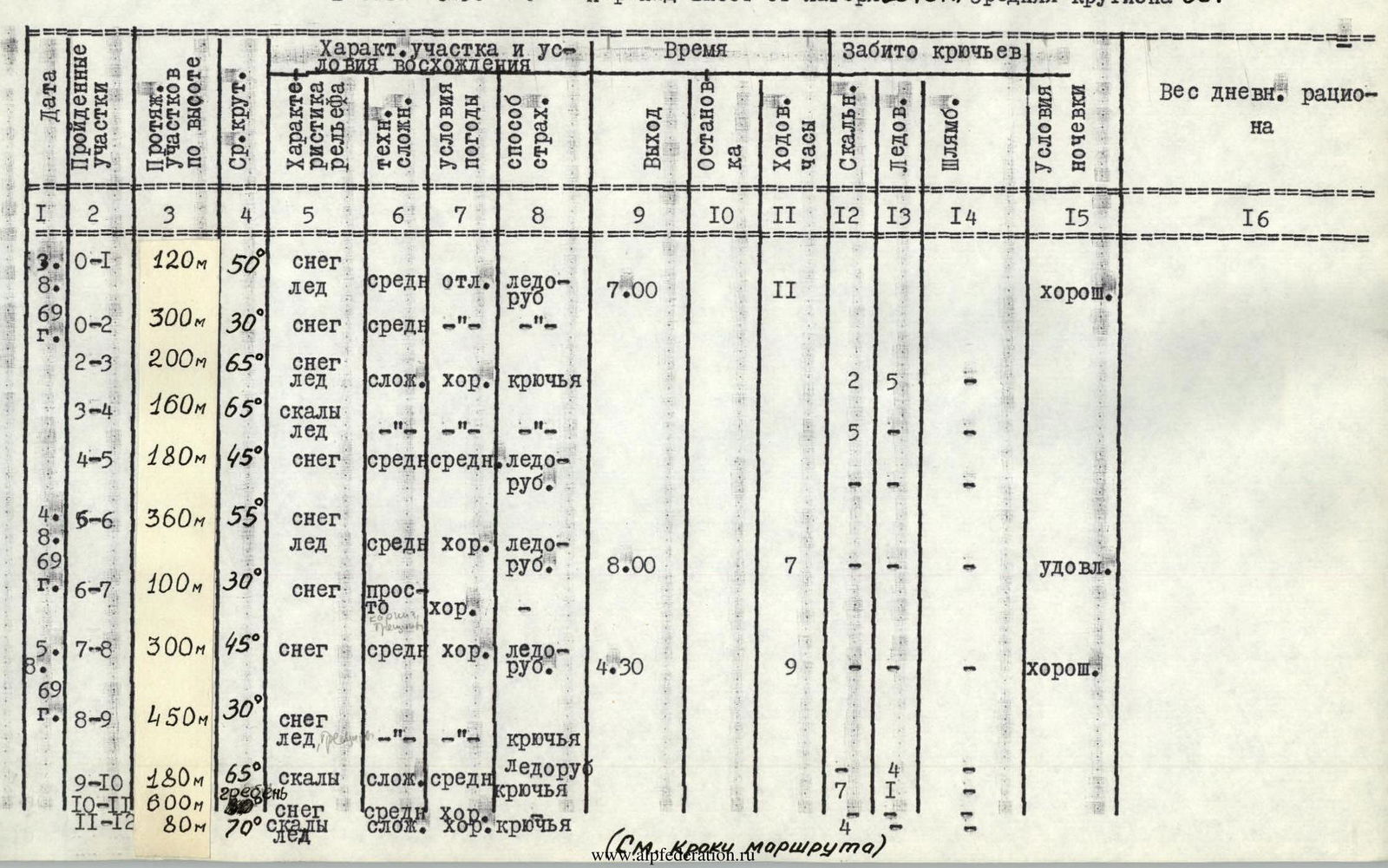
Description of the ascent
August 1, 1969
Departure from base camp 3500 at 12:00. Along the left (in the direction of travel) side of the Maly Tanymas glacier, movement towards a couloir opposite the South Sandal gorge. From the couloir, down a rocky chute to the Maly Tanymas glacier, then crossing the moraine towards the left (in the direction of travel) slope of the gorge — 2 hours. (See the map of the area hereafter)
Ascent up the scree of the left slope of the gorge, bypassing the ice fronts at the foot of the South Sandal glacier, exit to the first step of the glacier (1 hour), which is an open part of the glacier, cut by transverse and longitudinal crevasses, and covered with small rocky scree.
Movement from the left slope diagonally from left to right, exit to visible snow and ice "ties" coming from the spurs of Peak Shilbe (1 hour).
Not reaching the "ties," before the second step of the glacier, a bivouac is set up. Platforms on the ice with artificial cover made from rocky scree (1 hour).
Walking time – 5 hours.
August 2
Departure from the bivouac at 7:00. Movement past the tongues of the "ties" towards the high icefall at the junction of the glacier and the spurs of Peak Shilbe. Movement in crampons in teams. Before reaching the icefall, up large ice blocks to the left. Cutting steps. Steepness 45–60°.
Further between seracs, exit to the middle of the glacier, from where two ice ridges are overcome straight up; turning left, approach to the "catacombs" — a deep passage between seracs. The "catacombs" are overcome in turn. Upon exiting the "catacombs," cutting steps. Further exit to a small snowfield and along the left (in the direction of travel) slope, approach to the "guitar" — a huge serac, bounded on the left and right by deep crevasses. Overcoming the "guitar" head-on (cutting steps, steepness 60–70°), exit to the second step of the glacier (4 hours).
In the direction up and to the right, approach to the third step of the glacier. The slopes of this part of the glacier have a steepness of up to 60°. On steep sections, cutting steps. The third step is a glacier of semi-open type: in the lower part — open, and when transitioning to the next step, the glacier gradually becomes closed (4 hours).
Further movement along the right side of the glacier in the direction of the visible saddle, with an exit to the shoulder of a snow and ice plateau. Simultaneous movement in teams (3 hours). On the plateau, platforms for tents are built (1 hour).
Walking time – 12 hours.
August 3
Departure from the bivouac on the plateau at 7:00. Weather is good. Movement towards the saddle between a large gendarme and a rocky ridge coming from Peak Shilbe. Movement in teams, alternating with belays through an ice axe. Upon exiting to the saddle, there are sections of bare ice. Steepness 45–60°. Cutting steps. Section R0–R1 (3 hours). (See photos and route sketches hereafter).
From the saddle, movement towards a small icefall hanging to the north. The icefall is bypassed to the left. Deep, loose snow. Trampling down platforms for belay through an ice axe. Section R1–R2 (1 hour).
Crossing, exit to a snow and ice ridge through a small snow couloir. The ridge is covered with a thin layer (up to 10 cm) of powdery snow. Steepness 75°. Cutting steps in the direction of rocky sections. Belay through ice screws. Section R2–R3 (3 hours).
On the rocky and icy section R3–R4, movement straight up (2 hours). Belay through ledges, ice and rock screws. Steepness 75–60°.
Above the rocky sections, ascent up a snowy ridge (section R4–R5). Steepness 45°. Movement in three pitches (2 hours), belay through an ice axe. In the middle of the ridge, building platforms for tents (2 hours).
Walking time – 13 hours.
August 4
Departure from the bivouac at 8:00. Movement along the ridge (steepness 45–60°) towards a small cornice with a deviation to the left. Belay through an ice axe (section R5–R6) – 4 hours.
The exit to the top of the gendarme ends with a vertical snow and ice wall (2 m). The wall is overcome using a ladder made from ice axes.
The further path to the saddle between the top of the gendarme and Peak Sandal is uncomplicated (section R6–R7) – 2 hours. Simultaneous movement of teams. On the saddle, a bivouac is set up (1 hour).
Walking time – 7 hours.
August 5, 1969
Departure at 4:30 (see the tactical ascent plan). Movement along the snowy ridge leading from the saddle of the gendarme to the snow, ice, and rocky slopes of Peak Sandal, which are cut by a bergschrund in the lower and upper parts. Simultaneous movement. Steepness 45° (2 hours). Section R7–R8. The lower bergschrund is overcome via a snow bridge, and the wall of the upper bergschrund — via a ladder made from ice axes (2 m).
From the bergschrund, movement up and to the right along a firn slope (steepness 30°) towards a not very pronounced couloir with rocky sections in the form of a small ridge to the right (in the direction of travel) of the couloir – section R8–R9 (2 hours).
Along the ridge of the couloir, steepness 60–70°, smoothing out and leading to the main ridge of the summit, movement of teams is alternating with belay through ledges, rock and ice screws. Key point: exit up a vertical rock and ice wall (6–8 m) to the opposite slope of the ridge. This section is passed with lower belay and belay through screws. Section R9–R10 (2 hours).
Further movement of teams is simultaneous, bypassing ridge rocky sections along the snowy pre-summit ridge to the pre-summit ascent. Steepness 30° (2 hours). Section R10–R11.
The pre-summit ascent is overcome on rocks with screw belay and belay through ledges. Steepness 70° (1 hour). Section R11–R12.
Descent from the summit is via the ascent route. From the pre-summit ridge, descent with screw belay and belay through ledges. The snowy section of the ridge is traversed simultaneously. Descent from the main ridge is done in a sporting manner. The last one descends on two ropes with subsequent pull-through. Further movement along the slope with belay through an ice axe — on fixed ropes. The bergschrund is overcome by the first with upper belay, the last — with lower belay. After the bergschrund, the teams move simultaneously to the saddle where the bivouac is located.
Walking time – 14 hours.
August 6, 1969
Descent from the gendarme. The first descends with upper belay, the last with lower belay. Simultaneously, teams are rotated. Belay through an ice axe. On the rocky and icy section, belay through ice and rock screws. From the rocky section to the icefall on the saddle, movement on fixed ropes with step-cutting and belay through ice screws. From the saddle of the icefall, descent on fixed ropes to the saddle with belay through an ice axe. From the saddle, simultaneous movement of teams to the plateau.
Walking time – 6 hours. From the plateau, descent to the first step of the glacier is done in crampons. Movement in teams, simultaneous. In places, on steep sections, step-cutting (7 hours).
From the first step, movement to base camp "3500" is along rocky scree (2 hours).
Walking time – 7 hours.
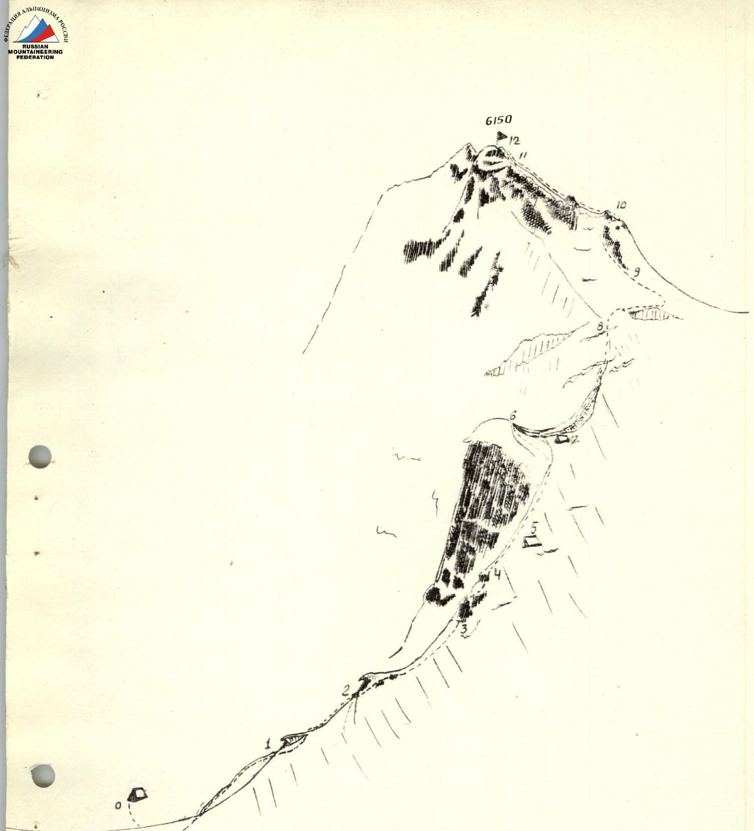
Route sketches for Peak Sandal
Bivouacs – Group's path
of the main sections of the ascent route to Peak Sandal via the northern edge from the Maly Tanymas valley. Height 6150 m. Height difference from the camp 2840 m, average steepness 50°.
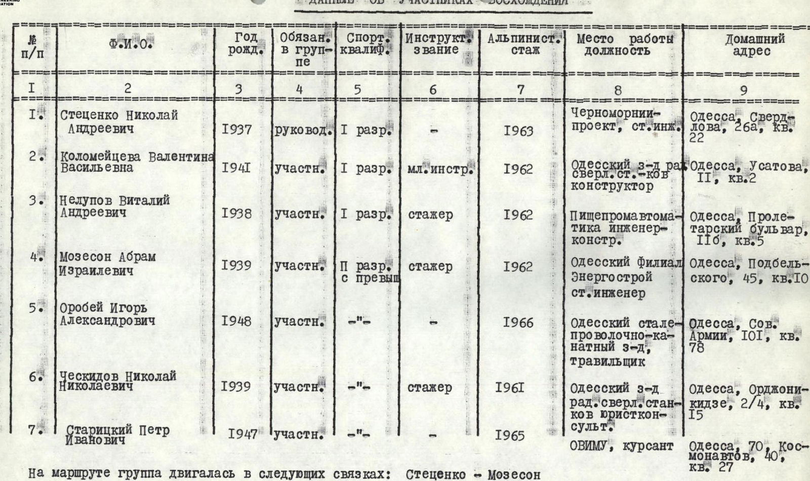
On the route, the group moved in the following teams: – Stecenko – Mozeson – Orobej – Kolomeyceva – Stecenko – Nelupov – Cheskidov