DESCRIPTION OF THE ASCENT OF PIK REVOLYUTSIONEROV VIA THE NORTH-WEST RIDGE (Pamir, Bivachny Glacier)
A group from the TsS DSO "Burevestnik" expedition, July 22, 1961.
Pik Rеvolyutsionerov is located in a lateral spur of the Marx-Engels ridge (fig. 1).

The first ascent of Pik Rеvolyutsionerov was made in 1957 by a group from the Uzbek expedition led by Nikonov. The group that reached the summit did not classify the route or leave any description of the ascent. A note retrieved from the summit (dated August 30, 1957) only indicates the direction of the path taken by the group to reach the summit and mentions the significant danger of the route due to:
- crumbling rocks
- steep rocks on the north-west wall.
On July 22, 1961, a group from the TsS DSO "Burevestnik" expedition consisting of:
- Vinokurov V.K., MS - leader,
- Kalachev L.D., 1st sports category,
- Milshtein I.M., 1st sports category,
- Lyubimov Yu.N., 3rd category,
- Zatrudina R.F., 1st sports category,
- Goryacheva V.S., 1st sports category,
- Kuznetsova G.D., 1st sports category,
- Simolin A.V., 1st sports category,
- Makova M., 1st sports category,
made an ascent of Pik Rеvolyutsionerov. Before the ascent, the group had no prior information about the route. Below is a description of the ascent route to Pik Rеvolyutsionerov via the north-west ridge.
The path begins at the confluence of the Bivachny Glacier and the Stalin Glacier and goes up a steep scree slope to the exit onto a crumbling ridge of red-brown rocks. The path along the ridge R1-R2 (fig. 2) initially does not present technical difficulties (rocks of 1B-2A category), but is heavily damaged and requires significant attention.
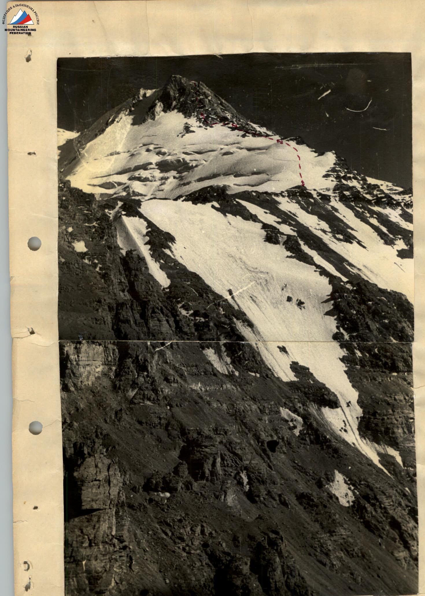
After the ridge turns northwest (section R2-R3), the path becomes more complicated due to several crumbling "gendarmerie" that are traversed:
- partially directly,
- partially bypassed on the left.
At times, the rocks alternate with short sections of snow. Movement is simultaneous with careful self-belaying. Before the first red-brown tower (section R3-R4), there is a night halt on good scree platforms.
The passage of the tower R3-R4 begins with a traverse up and to the left under the wall. Then the path goes up the rocks to the exit onto the left edge of the tower. The rocks are heavily damaged, category 3, and require great caution during passage. Large ledges are available for belaying. Further along the ridge, there are heavily damaged rocks with careful belaying during simultaneous and partially alternating movement. The tower and the ridge section R4-R5 have several sharp "gendarmerie" that are initially (the first three) traversed directly, and then bypassed on the left along scree ledges. The rocks of the tower and ridge R4-R5 are category 3. Further, the ridge levels out and turns into a steep ice-snow slope with a slope angle of up to 25-30°. Four to five ropes are traversed using ice screws and crampons to the exit onto the rocky ridge. The path along the ridge R6-R7 goes partially through snow and partially traverses three uncomplicated "gendarmerie". The rocks of the "gendarmerie" are damaged, category 2-3. Under the wall of the summit (section R7), there is a night halt.
The section R7-R8 presents the main technical difficulty of the ascent. The entire wall has an average steepness of 40-45° with individual sections up to 50-55°. The path up the wall is approximately 200-250 m. The rocks are exceptionally damaged with alternating steep sections. The passage of the wall requires careful piton belaying. There are many loose rocks on the ledges. The rocks are category 4. The wall is traversed by ascending from the end of the ridge to the right and upwards. A small snow "tie" in the first half of the path with a black rock outcrop on it can serve as a landmark. The exit from the rocks onto the "tie" is particularly dangerous: the snow is steep and turns into scree rocks covered in ice. Reliable cracks for piton belaying are found with great difficulty. In the second half, although the overall steepness of the wall is greater, the path becomes easier due to the abundance of outcrops for belaying during alternating movement of the rope teams. The exit onto the summit tower is located on the right side at the end of the summit ridge made of white rock. After passing the wall, the path goes along the ridge with detours to the right around individual sections. The path does not present significant technical difficulties and leads to the summit of the peak. The entire ascent took the group three days. On the first day, it took 6 hours of walking time to reach an altitude of 4300 m, on the second day - 8.5 hours of walking time to the night halt under the summit tower (altitude 5000 m), and on the third day - 9 hours (including descent to the night halt under the summit tower). Descent was made along the ascent route.
Comparing the height of Pik Rеvolyutsionerov with the height of Pik Tельmana (6018 m), the col before the ridge of Pik Molotova (5800 m), and the beginning of the upper firn fields of Pik Stalin (6000 m), we estimate the height of Pik Rеvolyutsionerov as 5850-5900 m.
We especially note the significant rockfall hazard of the route due to the heavily damaged rocks.
The ascent of Pik Rеvolyutsionerov via the north-west ridge is rated by the group as category 4A and can successfully serve as a training ascent before high-altitude routes of the highest category of difficulty.
Other ascent paths to the summit of Pik Rеvolyutsionerov can be recommended. The main ones are:
- North-west ridge
- West ridge
- South-west couloir
- North wall
a) Ascent via the west ridge from the cirque of the upper Bivachny Glacier. This path is technically simpler (category 3B), but has the most damaged upper rocks and laborious approaches through numerous steep scree slopes.
b) Ascent from the col between Pik Rеvolyutsionerov and Pik "40 let Oktyabrya" via the south ridge. Approximately category 3B. The exit to the col is via the gorge between the spurs of Pik Tельmana and Pik Liebknecht.
c) Ascent via the north wall without traversing the north-west ridge. The exit to the wall is directly from the lateral gorges of the north-west ridge. Considering that in this case, it is necessary to traverse sections R5-R9 (see fig. 2), these ascent paths can be rated as category 4A.
d) A good acclimatization and training ascent will be the ascent from the east to the col between Pik Rеvolyutsionerov and Pik "40 let Oktyabrya" with further ascent to both summits and from Pik "40 let Oktyabrya" to Pik Tельmana (6018 m). This ascent provides a full view of the Marx-Engels ridge, the Garmo massif, and the Fedchenko Glacier.
The ascent can be approximately rated as category 4B-6B.
Group leader
 (V. Vinokurov)
 General view of Pik Rеvolyutsionerov.
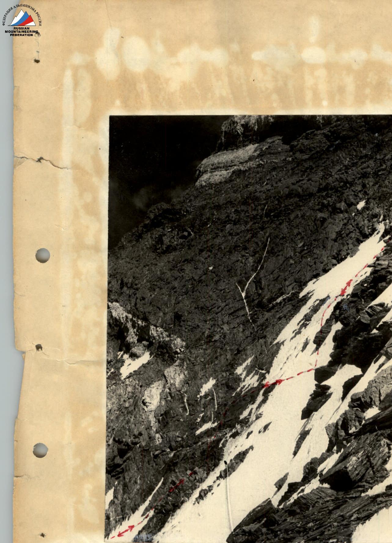 Section of the route along the wall R7-R8.