86
THIS ASCENT IS DEDICATED TO THE MEMBERS OF THE GROUP WHO DIED ON PIK PATRIOT IN 1953 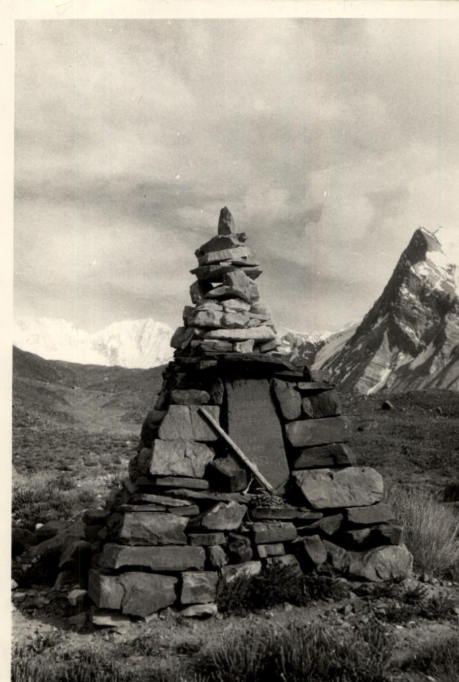

Protocol No. 201 dated November 2, 1962 5B+1
Description of the Ascent to Pik Patriot
Ascent to Pik Patriot via the western ridge (Pamir, Garmo Glacier), July 1962.
Group of the joint Soviet-British expedition to Pamir.
July 26, 1962.
Pik Patriot is located in the Academy of Sciences Range (Fig. 1). The first ascent to Pik Patriot (then known as Peak 6350 m) was made by a group of climbers from the "Lokomotiv" society led by B. Garf in 1950 via the southwest ridge, categorized as 5B.
Garf, with the aim of scouting approaches to Pik Kommunizma, ascended to the upper cirque below Pik Patriot (photo 2) to traverse the spur extending from the Academy of Sciences Range (the western ridge of Pik Patriot). Garf wrote about the ascent options to Pik Patriot: "It was not possible to traverse the spur: it rose as a 300-meter wall (see photo 3)."
These words were taken from D. M. Zatulovsky's book "Among Snow and Rocks," p. 200.
It was via this wall and then along the western ridge that the duo of climbers made the first ascent:
ALUTOV N. A. — 1st sports category, MALAKHOV V. D. — 1st sports category, from the joint Soviet-British Pamir expedition in 1962. For the ascent to Pik Patriot, a group departed from the base camp at the tongue of the Garmo Glacier.
Malcolm Slessor — leader
Group members:
- Joe Brown
- McNought Davies
- Kenneth Brian
- Nikolai ALUTOV
- Vladimir MALAKHOV
The group's path from the base camp at the tongue of the Garmo Glacier followed a trail along the right (orographically) moraine of the glacier to the Avo-Dara River, where some expeditions in the area set up their base camp. The journey took about 4 hours.
After Avo-Dara, the trail goes up the moraine, from which, after 700–800 m, it descends down to the glacier.
The glacier is mostly covered with rocks, but there are strips of clean ice. In 1962, it was most advantageous to follow the leftmost (in the direction of travel) strip of clean ice to reach the traverse of the Shokalsky Glacier, then cross two ridges of rocks and exit onto the rightmost (in the direction of travel) clean strip of ice, continuing up the Garmo Glacier for another 2 km. Then, follow one of the streams cutting through the deep canyon on the left (orographically) moraine to ascend. On a clearing fenced off by the moraine from the glacier, there are excellent camping spots.
Altitude — 3700 m. The journey from Avo-Dara to this location takes 3–4 hours.
After the camp, the trail leads up along the moraine ridge. 20 minutes from the clearing, there is a lake, above which, on the moraine ridge, is a suitable spot for tents.
Further, the trail leads to the rocky rib of Pik Shcherbakova. To ascend, one should:
- go up-right via a couloir, exiting onto a green slope overgrown with wild onions;
- traverse the slope up-right;
- reach the Old Surkov Camp, located at the confluence of the Vavilov Glacier into the Garmo Glacier.
The journey from the lake takes 40 minutes.
From the Surkov Camp (altitude — 4000 m), the entire route to Pik Patriot is visible, except for the snowy cirque before the summit and the lower part of the exit to the ridge.
Further, the path goes to the right (orographically) moraine of the Vavilov Glacier through an icefall present in the lower part of the glacier. The journey takes 1 hour. A good spot for camping is by the lake behind the second moraine ridge (photo 1).
From the camping spot by the lake, the path goes up along the steep right (orographically) moraine of the glacier, which descends from the cirque of Pik Patriot to the Vavilov Glacier in a huge icefall.
We ascend the moraine to a large plateau below the slopes of the peak (5600 m), closing the spur extending from Pik Patriot. From the plateau, veering left in the direction of travel, we exit onto easy snowy rocks, unnoticeably transitioning into a snow-covered glacier. The glacier is broken; it is advisable to move cautiously, preferably tied up. Movement is along the right (orographically) part of the glacier, orienting towards a large rocky outcrop located in the middle of the cirque, dividing the upper step of the cirque from the lower (photo 2).
Below the rocky outcrop are two lakes — a good camping spot. Altitude — 4600 m. Travel time from the lake by the Vavilov Glacier — 3 hours.
From the camping spot, bypassing the outcrop on the left, we exit into the upper part of the cirque and head towards the western ridge of Pik Patriot, orienting towards its lowest part (photo 3).
A 70-meter steep conical snow patch helps to locate the start of the ascent up the wall. This snow patch should be traversed very attentively — avalanches from the ridge are possible. At the top, the snow patch ends in a narrow vertical couloir completely filled with ice. 20 meters before this ice plug, we veer left and, using rock ledges with piton protection on the rocks, reach the base of a steep snow slope ending on the glacier with a 50-meter rock wall. The ledges — one 50-meter rope, 4 rock pitons. We ascend the steep snow slope (about 50° steepness) for two ropes up-left, chopping steps on short ice sections. Protection is on rocky outcrops (4 pitons).
At the base of the rock wall, 2 paired rock pitons are hammered in because the cracks are unreliable, and the rocks are heavily deteriorated with many loose stones (photo 4).
The path up the rock wall is directly upwards with careful piton protection, using two 50-meter ropes; 10 rock pitons are hammered in, and 30-meter ladders are hung from an auxiliary English rope.
Then, traversing 10 m left, we enter a narrow rocky couloir, very prone to rockfall on the left (orographically) side, where we begin the ascent, always veering right, exiting onto a steep snow slope to a small rocky ridge (photo 5) — 50 m, 4 rock pitons.
To exit onto the ridge, we hang ladders.
Along the rocky ridge, we approach a 20-meter rock wall (steepness about 80°); the wall is traversed head-on with piton protection, exiting onto the ridge. We move along the ridge right, somewhat losing altitude, and, bypassing a snowy rise on the left, we enter a depression with a small lake. The only good camping spot on the entire ridge (photo 6). Altitude — 5200 m.
Here, the duo of Malcolm Slessor and Kenneth Brian, feeling signs of altitude sickness, remain. We continue the journey in fours. Processing the wall from the upper cirque to the exit onto the ridge to the camping spot by the duo without backpacks takes one working day. Traversing this same route with backpacks along the hung ladders takes about 7 hours.
Despite the predominance of sheer sections up to 50 m in length on the entire route, on a solid rocky foundation, there are many loose stones of various sizes. Snow lying on gentle sections does not hold because there are voids under the snow, requiring continuous protection on the rocks.
From the camping spot by the lake upwards, there is a snowy ridge with steepness, in its steepest part, reaching 45°, leading to a gendarme. On this slope, it is advisable to prepare steps the night before, traversing it without backpacks, which we did because the ridge drops off on the right (in the direction of travel) with a sheer rock wall, and the snowy field veering left gradually becomes steeper, ending in ice drops onto the Belyaev Glacier (photo 7). In the upper part of the ridge, snow gradually gives way to ice. Therefore, with step-kicking, we traverse right to the nearest rocky outcrop.
Further along the slope with piton protection on rocky outcrops, we approach the base of the sheer gendarme (one 50-meter rope, 2 pitons). To bypass this gendarme:
- descend from the ridge 10 m to the base of the gendarme;
- with careful piton protection on the gendarme's walls, initially bypass it closely;
- gradually moving away, exit onto a snowy shoulder of the snowy slope, dropping off sheer into the cirque of Pik Patriot (see photo 3).
The most challenging part of this bypass is the first 2 ropes because the gendarme's base is an inclined ledge with about 60° steepness, also dropping off sheer into the cirque of Pik Patriot; the snow on the ledge has melted and barely clings to the rocks. A total of 4 ropes was spent on bypassing the gendarme, and 12 rock pitons were hammered in. After exiting onto the snowy shoulder, the path lies up-left along the snowy slope to the gendarme's summit with step-kicking and piton protection on rocky outcrops (photo 8). The slope's steepness is about 40°, six 50-meter ropes, 12 pitons.
The gendarme's summit is two snowy rock steps inclined towards the cirque of Pik Patriot and dropping off towards the Belyaev Glacier. Due to the approaching bad weather, we are forced to seek a camping spot. On a narrow, sharp ridge between the gendarme's summit and the continuation of the ridge leading to the snowy shoulder of Pik Patriot, we clear the ridge and build a platform for a tent from stones (photo 9).
The time required to bypass the gendarme (including overcoming the snowy slope from the lake along ready-made steps) is about 7 hours.
In this camp at an altitude of about 5500 m, our foursome weathered two days due to bad weather, while the duo of Slessor and Brian was at the lake camp (5200 m).
From the camping spot at 5500 m, the path goes upwards, initially along rocks of medium difficulty, which are traversed with piton protection (2 ropes, 4 pitons).
Further, along a steep snowy slope, we traverse right (in the direction of travel), bypassing a sheer rock wall blocking the path along the slope, with piton protection on rocks under the wall (5 pitons — photo 8).
After bypassing the wall, we move up along the snowy slope with piton protection on rocky outcrops to the snowy shoulder of Pik Patriot (5 ropes, 10 pitons).
The average steepness of the slope leading to the snowy shoulder is 40–45°, with sections of ice, especially near rocks, which require step-kicking. The entire snowy slope, due to its great steepness, must be traversed with mandatory protection on rocky outcrops (photo 10).
Along the snowy shoulder, we advance with alternating protection via an ice axe to a rocky outcrop and further to a gendarme snowed in on the left (4 ropes — photo 11). After overcoming a small rock wall (2 m), we bypass the gendarme on the right (in the direction of travel) along snowy, inclined ledges with piton protection on the gendarme's rocks. Further, the path is blocked by a rock wall (15 m) with about 80° steepness, exiting onto the gendarme's summit. Bypassing the gendarme and exiting onto its summit takes 4 ropes, with 10 pitons hammered in.
From the gendarme's summit, the path goes along a sharp ridge, representing a series of successive snowy rises traversed with alternating protection via an ice axe. The snow on this section is deep and very loose; we have to dig a trench. Despite insulated footwear, our feet on this section froze completely — we had to stop and rub our feet.
The ridge leads under a rocky tower (photo 12), from the summit of which begins the ridge leading to the summit of Pik Patriot.
Although the duo of Joe Brown and McNought Davies traveled from the camping spot at 5500 m second and lightly because the camp was left at 5500 m, they turned back at the start of the ascent to the tower, citing the impossibility of continuing due to fatigue. We attempted to reach the summit on the same day but by 16:00, under the threat of a cold bivouac, having passed the tower and exited onto the pre-summit ridge, were forced to turn back.
On the same evening, the British duo left the 5500 m camp and began their descent, refusing further ascent. We decided to continue the ascent as a duo, agreeing with the descending British duo on a control deadline and specifying light signaling.
The next day, remaining as a duo, we moved the 5500 m camp under the rocky tower, establishing a 5900 m camp. The following morning, we resumed the ascent.
The simplest path to overcome the tower is to bypass it on the right (in the direction of travel) along snowy rocks.
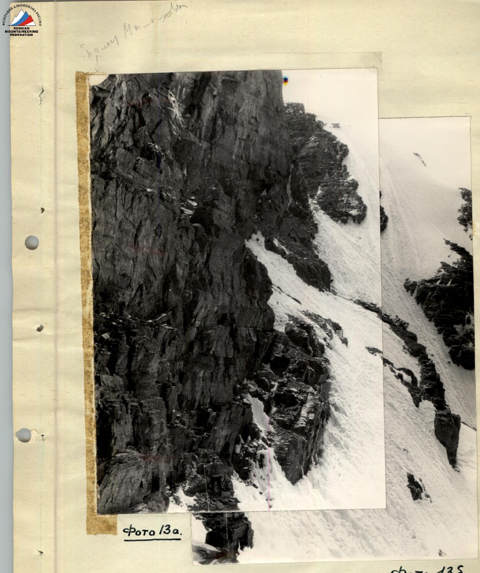
We bypass the rocky tower on the right and, along heavily snowy rocks, exit under a 35-meter sheer rock wall (photo 13-a). Further bypass of the tower is impossible due to the steepness of the snowy slope (photo 13-b) and the absence of outcrops for movement; therefore, we begin the ascent up the wall head-on.
From a piton hammered at the base of the wall, we move forward-up along rocky outcrops for 8 m, then move up using wall irregularities and artificial points of support (rock pitons). After 13 m, the first climber reaches a ledge below an overhanging stone, where they organize the reception of the second in the rope team.
Two paths are then possible: directly upwards with piton placement and bypassing the stone on the right. Both paths traverse the wall with a slight negative incline. This should be considered when choosing a spot to hammer in pitons. The length of the second section is 10–12 m.
After this section, the wall begins to flatten, good handholds appear, and further, after traversing 10 m, it is possible to organize a reliable reception point for the second in the rope team. This is the summit of the tower. A total of 9 rock pitons were hammered in on this wall.
From the tower, we begin movement along the ridge to the saddle between the tower and the pre-summit ridge. The saddle is traversed with careful protection because it represents a sharp rocky knife-edge with cornices towards the Belyaev Glacier.
The entire ridge from the saddle to the pre-summit tower is a steep snowy slope, with rocky outcrops protruding in places. The rocks are heavily deteriorated, with many stones frozen in ice, several large cornices towards the Belyaev Glacier. All this requires extreme caution during movement because careless touch on some stones, seemingly firmly frozen in ice, could cause them to plummet right into the cirque of Pik Patriot.
Much time was spent processing the path through deep (above the knee) loose high-altitude snow, often lying on an icy base. On all such sections, it was necessary to clear stones by hand, on which piton protection was organized.
The final section of the ridge to the pre-summit tower was traversed with step-kicking. Movement along the ridge:
- 6 fifty-meter ropes
- about 10 pitons hammered in
The icy slope of the ridge, covered with a thin layer of snow, leads under a small rock wall of the pre-summit tower, where monolithic rocks and good cracks allow for reliable piton protection.
In our opinion, there are two paths to ascend the pre-summit tower:
- immediately left of the wall, along a very steep, snow-filled couloir, which exits somewhat right of the highest point of the pre-summit tower;
- significantly left of the rock wall, along a not clearly defined couloir, leading to a small platform in the middle part of the tower.
We chose the second, more accessible path. To do this, one must exit from under the rock wall left for a whole 50-meter rope along very deep (waist-deep) snow to the start of the ascent in the couloir, where on the rocks, it is possible to receive the second in the rope team and organize piton protection.
The tower is a pile of huge slabs and stones covered with snow. Climbing short sections is challenging because one has to clear barely noticeable handholds from snow and, in places, rime ice; several stone blocks turn out to be loose, forcing us to exit the couloir right and ascend the tower head-on.
Due to reliable protection via ledges along the entire ascent path to the tower (1 rope), only 3 pitons were hammered in, with the last one on the summit of the pre-summit tower, from which to the summit leads a very sharp snowy ridge with about 25–30° steepness and possible cornices left (in the direction of travel).
Up the ridge, at a distance of one rope, there is a rocky outcrop where reliable protection can be organized via a ledge. Further, we decide not to continue the ascent along the ridge due to the unreliability of protection but to traverse the snowy slope of approximately the same steepness right, where, at a distance of about one rope, a group of rocks is visible. With protection on these rocks, along deep snow with about 30° steepness, we exit onto the highest point of Pik Patriot. This was at 14:30; the entire journey from the 5900 m camp to the summit took more than 8 hours. The worsening weather prevents us from capturing a panorama from Pik Patriot; strong wind blows from the summit. Since the summit is snowy, we decide to build a cairn a few meters below on the upper rocky outcrop (photo 14).
We quickly write a note and begin the descent to the 5900 m camp along the ascent route. The descent is facilitated by the pitons left on key sections of the route.
On the same day, after dismantling the 5900 m camp, we managed to reach the 5500 m camp only by 20:00, where we stopped for the night. The next day, by 18:00, the British members of our group were met in the Old Surkov Camp by the lake. The ladders on the 300-meter wall were left in place. The further journey to the base camp at the tongue of the Garmo Glacier takes another day.
The group used the following equipment for the ascent:
-
- Double-layer tents — 2 pcs. (ours and the British one)
-
- Two-person tents — 2 pcs. (British)
-
- Down sleeping bags — 6 pcs.
-
- Main ropes
- 9 mm, 50 m — 2 pcs.
- 8 mm, 90 m — 1 pc.
-
- Auxiliary rope
- 10 mm, 120 m — 1 pc.
-
- Ice axes — 6 pcs.
-
- Rock pitons — 30 pcs.
-
- Ice pitons — 10 pcs.
-
- Our carabiners — 3 pcs.
-
- British lightweight carabiners — 30 pcs.
-
- Ten-toothed crampons — 6 pcs.
-
- Rock hammers — 4 pcs.
-
- Gas stoves on butane — 3 pcs.
-
- Butane in canisters — 15 pcs.
-
- Provisions for 12 assault days.
In the first part of the ascent, due to the large quantity of supplies and equipment (with the British), the group had to cache loads using a relay method. Further, after the 5500 m camp, backpacks became significantly lighter and did not exceed 10 kg.
The group considers the most challenging sections of the route to be: the ascent to the ridge from the cirque, bypassing the 1st gendarme, ascending the 30-meter wall to the rocky tower, and ascending the pre-summit tower.
The most challenging section is the ascent up the 30-meter wall. Along the entire route, about 100 rock pitons were hammered in and only 2 ice pitons.
The total number of days required for this ascent, excluding days lost to bad weather, is 9 days.
The group considers the route to Pik Patriot via the western ridge to be category 5B.
PARTICIPANTS: /ALUTOV/, /MALAKHOV/
Fig. 1
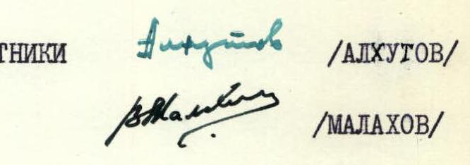
Photo 1. Group of climbers from the Soviet-British expedition before the assault on Pik Patriot by the lake in the Surkov Camp. In the corner on the left, a bay of auxiliary rope is hung on the wall. On the right — 50 and 90-meter ropes used during the ascent.
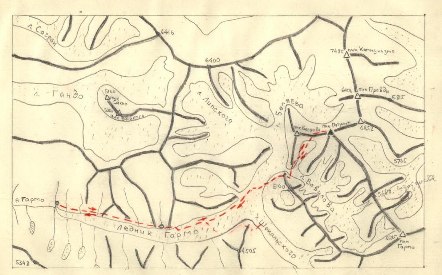
Photo 2. Upper cirque of Pik Patriot with a view of Pik Patriot. In the center of the glacier — a rock under which a camp was set up.
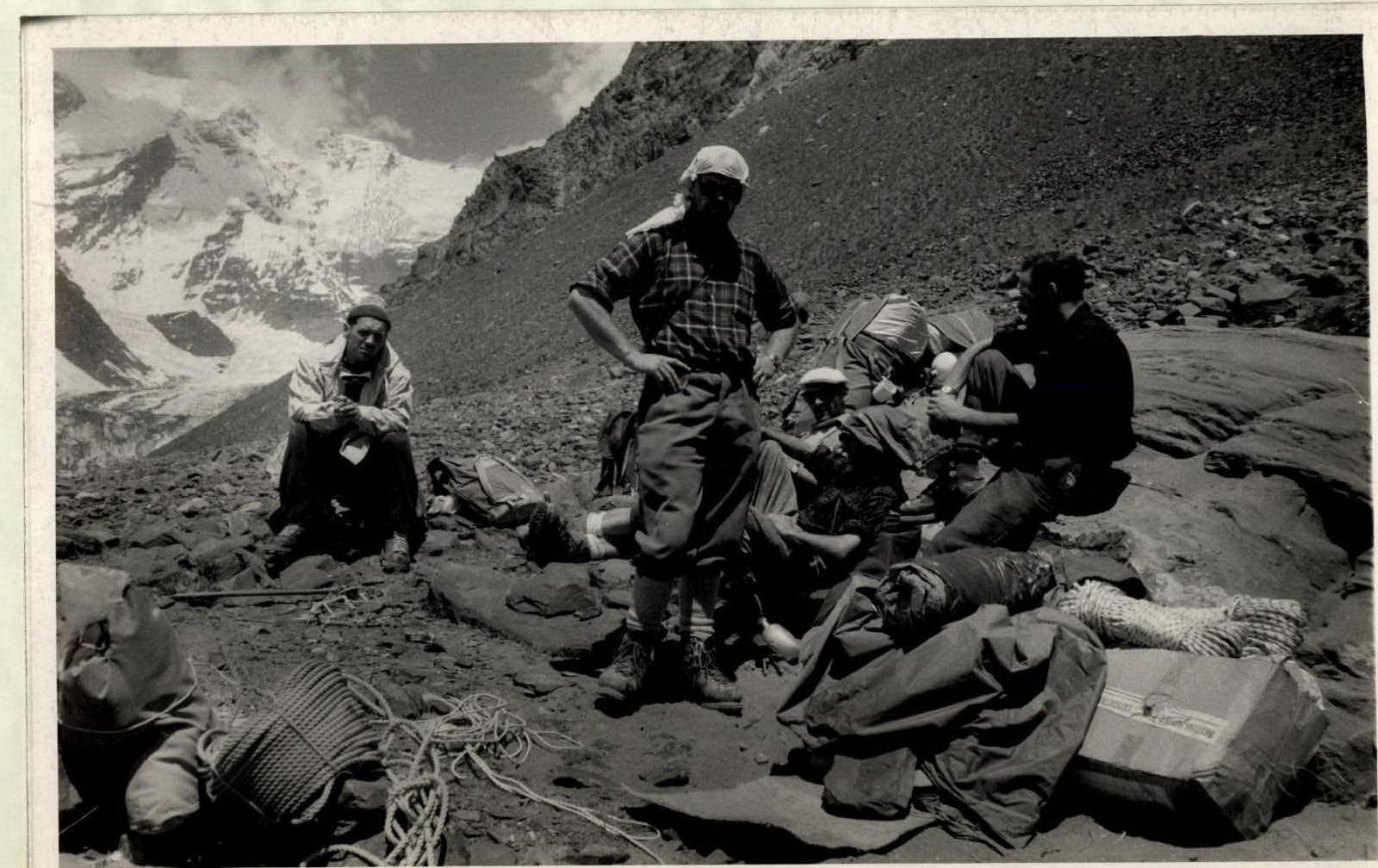
Photo 3. 300-meter wall leading to the western ridge of Pik Patriot.
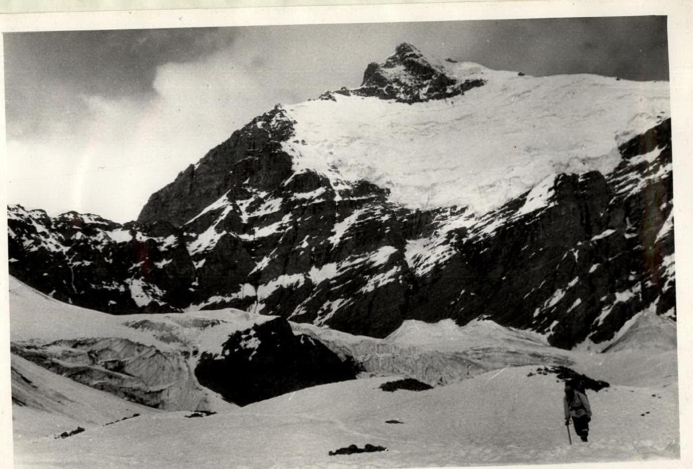
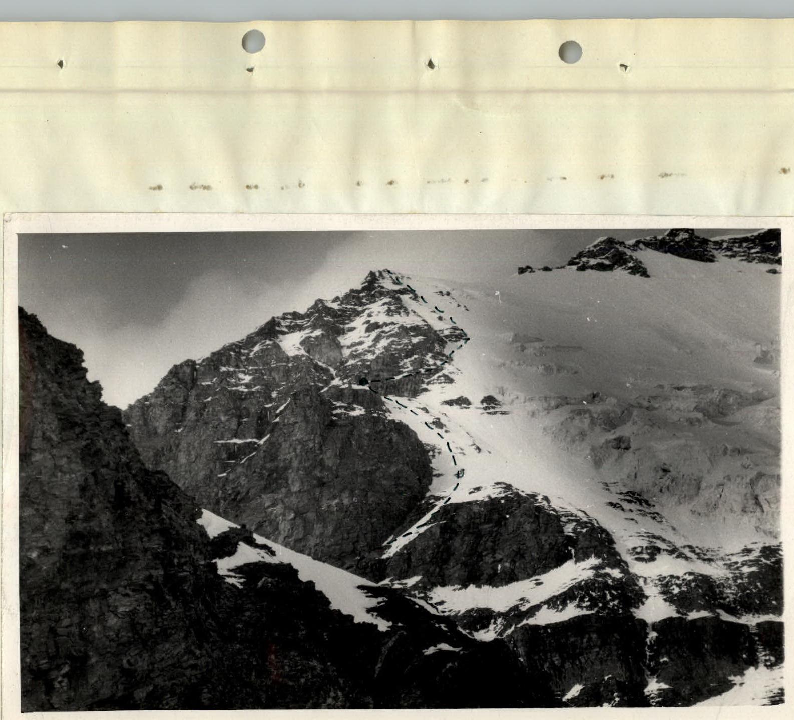
Photo 8. Middle part of the route from the base of the gendarme to the camp under the tower / camp 5900 m.
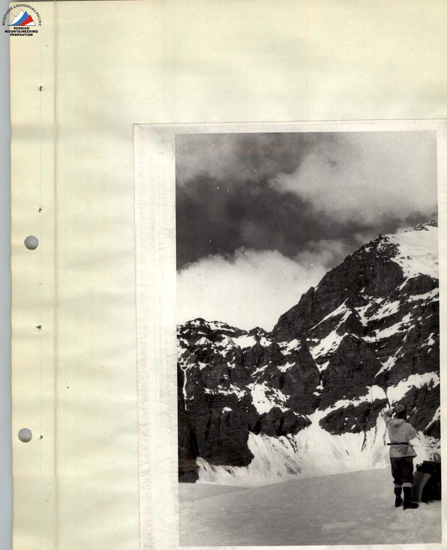
Photo 13a. Wall leading to the summit of the tower (Photo 13b.)
Wall leading to the summit of the tower.