–2– ASCENT DOCUMENT
- Ascent Class — High-altitude Technical
- Ascent Area — North-western Pamir. Okt. Magistral
- Ascent Route — with indication of the summit and its height
Peak Miroshkin (5900) via the south-eastern spur, approximately 5A cat. dif. (first ascent)
-
Ascent Characteristics — height difference — 1200 m average steepness — 45° length of complex section — 100 m
-
Pitons hammered in: rock — 20 ice — 9 bolt — –
-
Number of climbing hours — 13
-
Number of nights and their characteristics — one, good night conditions, lying down, on the shoulder of the north-eastern ridge of the summit.
-
Team Name — Combined Team of Naryngidroenergostroy and Kyrgyz "Burevestnik"
-
Full Name of the leader, participants and their qualifications:
- Sabirov Mamasali — leader CMS
- Kuzmenkov Vyacheslav Mikhailovich — participant 2nd sports category
- Elansky Valery Ivanovich — participant 2nd sports category
- Alexandrov Andrey Valerianovich — participant 2nd sports category
- Reshetnikov Sergey Vladimirovich — participant 2nd sports category
- Orlov Sergey Tikhonovich — participant 2nd sports category
-
Team Coach — Master of Sports Tustukbaev A.K.
-
Date of departure and return: — 19 August 1974 — 20 August 1974

Corrected 14 February 1977.
Orographic Scheme of the Peak Kommunizma Area
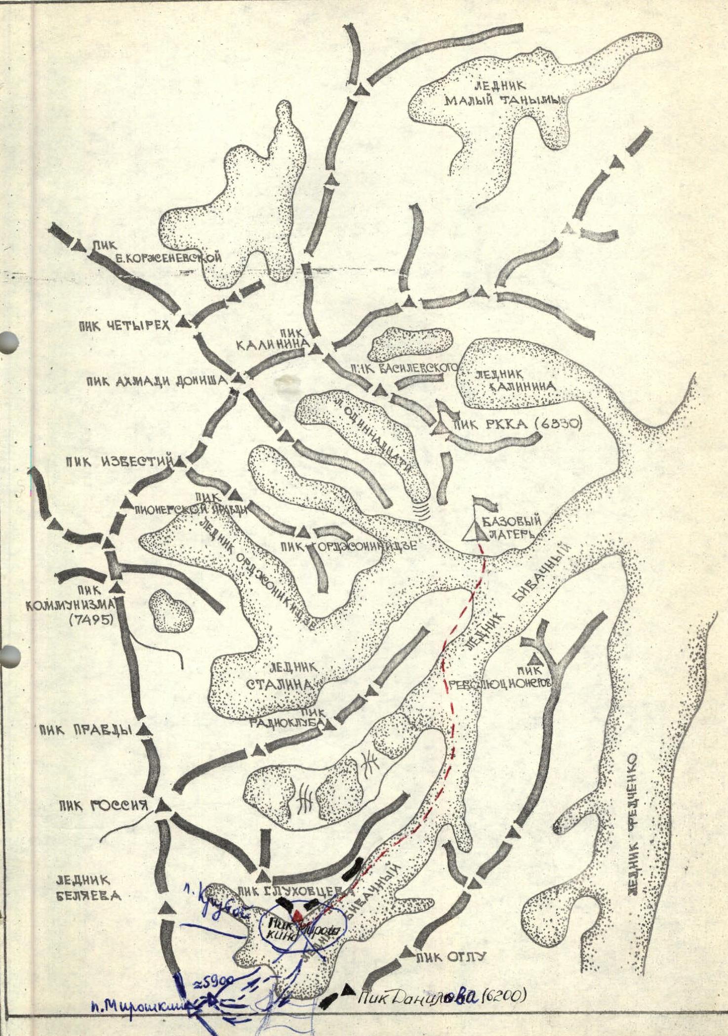
Brief Geographic Description of the Area and Sporting Characteristics of the Ascent Object
The North-Western Pamir area is relatively accessible and frequently visited by climbers.
The significant height and complex orography of the North-Western Pamir's highest uplifts — the grandiose ridges of Peter I and Academy of Sciences, as well as their numerous spurs, have long attracted the attention of researchers and climbers…
Here, at the junction of the Peter I and Academy of Sciences ridges, is located the highest peak in the Soviet Union — Peak Kommunizma (7495 m).
In this area are such well-known peaks as: – Peaks Garmo – OGPU – Rossiya – Akhmad Donish – Vasilevsky – Kalinin – Krasnaya Armiya
From whose slopes flow large and small glaciers, feeding the powerful Bivachny glacier — a left tributary of the world's largest Fedchenko glacier.
The Central Council of the Burevestnik Sports Society's expedition plans included a number of first ascents on Pamir peaks, including teams of climbers from the Frunze Polytechnic Institute and NarynGESstroy.
The objects of ascent were chosen to be peaks "6200" and "5900", located in the upper reaches of the Bivachny glacier; their passage was entrusted to the combined teams of Kyrgyzstan.
It was decided to lay a route to the summit of peak "6200" via the western spur, approximately 5A cat. dif. (Akopyan's group). Peak "6200" was named after the climber Danilov.
Peak "5900" was previously conquered by a team making a traverse of many peaks and named p. Miroshkin, on which Sabirov M.'s group passed a route via the south-eastern spur (photo 2) approximately 5A cat. dif.
The ascent was made in honor of the 50th anniversary of Soviet Kyrgyzstan and its Communist Party. On the summit of peak Miroshkin on 20 August 1974, the state flag of the republic was left.
The south-eastern spur of p. Miroshkin is composed of deeply metamorphosed rocks: marbles and schists with widely developed endogenous and exogenous fracturing.
Description of the Route
17 August
The group set out for the first ascent of peak "5900" (p. Miroshkin) in the following composition:
- Sabirov M. — leader CMS
- Kuzmenkov V.M. — participant 2nd sports category
- Elansky V.I. — participant 2nd sports category
- Alexandrov A.V. — participant 2nd sports category
- Reshetnikov S.V. — participant 2nd sports category
- Orlov S.T. — participant 2nd sports category
Support group:
- Akopyan Y.A. — leader MS
- Musienko V.V. — participant 1st sports category
- Nikolaev A.N. — participant 2nd sports category
- Telbukh P.G. — participant 2nd sports category
- Gnatush N.I. — participant 1st sports category
We left the base camp on the Bivachny glacier at 10:00 and, moving across complex terrain to the upper reaches of the Bivachny glacier, arrived at a large stone under the north-eastern ridge of p. "5900" at 20:00, where we set up camp.
18 August
From the "U kamnya" (At the stone) camp, we moved to the upper reaches of the Bivachny glacier, bypassing the ascent object along the eastern slopes to determine the most rational and interesting route to the summit.

Photo 1. Bivouac on the Bivachny glacier
The south-eastern spur immediately caught our eye (photo 2), but we decided to continue the reconnaissance route and examine as much as possible. We went to the very end of the Bivachny glacier, i.e., we went around the summit from the east and south, but a more logical route than the south-eastern spur was not found.
We returned to "our" spur and set up camp on the glacier opposite the chosen route. Time 19:00.
19 August
We set out at 8:00 in two ropes (Sabirov, Kuzmenkov, Elansky and Orlov, Reshetnikov, Alexandrov) and crossed the glacier, ascending a snow-ice slope 200 m long with a steepness of 40–50°, leading to the spur. In the upper part of the slope — smooth ice, where crampons, piton belay, and ropes were used (section R1). Petrography of rocks: marbles, highly weathered and steeply inclined towards the glacier. The spur begins with a 30-meter steep wall, partially iced. Climbing is complex. Piton belay is organized, and ropes are hung (section R2). The route then follows a steep (60°) fairly narrow ridge, which leads to the right under steep (80°), smooth, but with wide cracks, slabs; climbing on the 15-meter slab section is complex. Piton belay (section R3). The slabs end in a small scree ledge at the top, and the route then follows the right part of the ridge, composed of broken rocks. The right part of the spur, which is clearly visible from the ledge, drops off with sheer walls (20–30 m) into a couloir heavily exposed to rockfall. The ridge is climbed using pitons (2 rock pitons) and rock outcrops (section R4). Further, the path is blocked by a 10-meter wall with an overhang at the top. To the left and right — rockfalls, it is impossible to bypass. Under the wall — a small inclined ledge, where two people — the first ascender and the belayer — gather with difficulty. The first goes without a backpack and successfully passes this complex section. 4 pitons are hammered in. Backpacks are pulled up, and a control cairn is built on a good monolithic ledge (section R5). Then 40 m along a steep ridge, belay via outcrops, and we reach a scree ledge. Time 13:30. Lunch. Further along the ledge into a snow-ice cirque and along the edge of rocks and ice to the left of the spur 80 m (2 ice pitons) (section R6). Then we ascend again to the ridge of the spur, which becomes simpler, with rocks of medium difficulty and easy rocks consisting of black schists with well-developed cleavage. The length of the ridge is 500 m, steepness — 40°. A total of 5 rock pitons were hammered in on this section (section R7). The ridge of the upper part of the south-eastern spur leads to the shoulder of the main north-eastern ridge of the summit. An excellent site, which we improve with gravel and schist slabs. Time 17:30. We build a control cairn. We examine the further route and are convinced that tomorrow will be snow and snow-ice work. We pitch a tent. Overnight stay.
20 August
We set out lightly, in crampons, in the same ropes at 9:00, and the first 150 m we walked along the gently rising ridge shoulder and the first snow-ice ascent, where we hammered in 1 ice piton (3 pitons). Then 40 m — a snow col, followed by a second snow-ice ascent with a steepness of 45°, where we had to overcome a bergschrund. Further, the ridge becomes gentler (80 m) and ends with a rock sub-summit, from which we descend to a 150-meter snow plateau (deep snow) and then along an 80-meter snow ascent to the summit. Below it, at the exit of rocks, a control cairn with a note from a team making a traverse of p. Garmo — p. Kommunizma was found. Time 13:00. We take photos with the State flag of the Kyrgyz SSR. At 13:30, we begin our descent to the shoulder with a camp along the ascent route and further along the north-eastern ridge to a col in the ridge. From the col, we descend to the left through a bergschrund to the "4 Krutoy" glacier (a glacier descending from the northern slope of peak Miroshkin) and along it to the Bivachny glacier and to the "U kamnya" camp. Time 19:00.