USSR Championship in High-Technical Ascent Class
Peak OGPU (6055 m)
Center of the northwest wall
Team of the Committee for Physical Education and Sports, Leningrad
Leningrad
1973
Brief Information on the Geography of the Region and Sporting Characteristics of Ascents to Peak OGPU
In the center of the northwest region of the Pamir, between the Fedchenko and Bivachny glaciers, there is a northwest spur of the Marx-Engels ridge, stretching from southwest to northeast, where Peak OGPU is located, discovered and mapped back in the 30s.
The height of Peak OGPU is 6055 m.
The peak drops steeply to the Bivachny glacier with sheer, rock faces; the slopes on the southeast side of the summit are less steep but longer. The southwest and northeast ridges of Peak OGPU are significantly less steep and more dissected.
The Bivachny glacier is relatively calm in its approach to Peak OGPU.
The first ascent of Peak OGPU was made by a team from the Central Council "Spartak" led by A. Kustovsky. In 1966, the team ascended the northwest wall on its left side and took first place in the USSR championship.
Then, in 1968, another ascent led by Stepanov, again by the Central Council "Spartak", took first place, but this time the route was on the right side of the wall.
The next ascent was made in 1972 by a team from the Central Council "Lokomotiv" on the right part of the center of the wall. The team took second place in the USSR championship, only surpassed by the team that ascended the southwest wall of Peak Engels.
The route of the Leningrad Committee for Physical Education and Sports team ran between the routes of Central Council "Lokomotiv" and Central Council "Spartak" (Kustovsky's team) on the central wall. The team aimed to follow a route close to the direttissima leading to the summit, and this goal was achieved.
Climbing Conditions in the Bivachny Glacier Area
A notable feature of climbs in the Bivachny glacier area is the remoteness of the region from populated areas.
The expedition traveled from under Peak Lenin to Darut-Kurgan - Altyn - Mazar - Bivachny glacier.
Base camp locations:
- near Peak Kosmonavtov;
- at the site used by the Central Council "Lokomotiv" expedition;
- base camp altitude 3600-3700 m.
The approach from the base camp to the wall of OGPU takes 8-9 hours.
The terrain of the western Pamir is characterized by a system of ridges with latitudinal and southwest orientations, separated by deep gorges. These ridges converge with the meridional ridge of the Academy of Sciences to the east. The crests of the ridges have a typical alpine-glacial relief with sharp peaks. The large altitude difference and steepness of the slopes make the terrain very dynamic, with rockfalls, avalanches, and icefalls.
The high altitudes of the Pamir, located in the subtropical zone, result in a very harsh climate. Due to the high elevation of the ridges in the Peak OGPU area, annual precipitation reaches up to 1000 mm, making the climate humid.
Due to the sharp continental climate, the snow line on the Pamir is located very high - at around 4400 m above sea level in the Fedchenko glacier area.
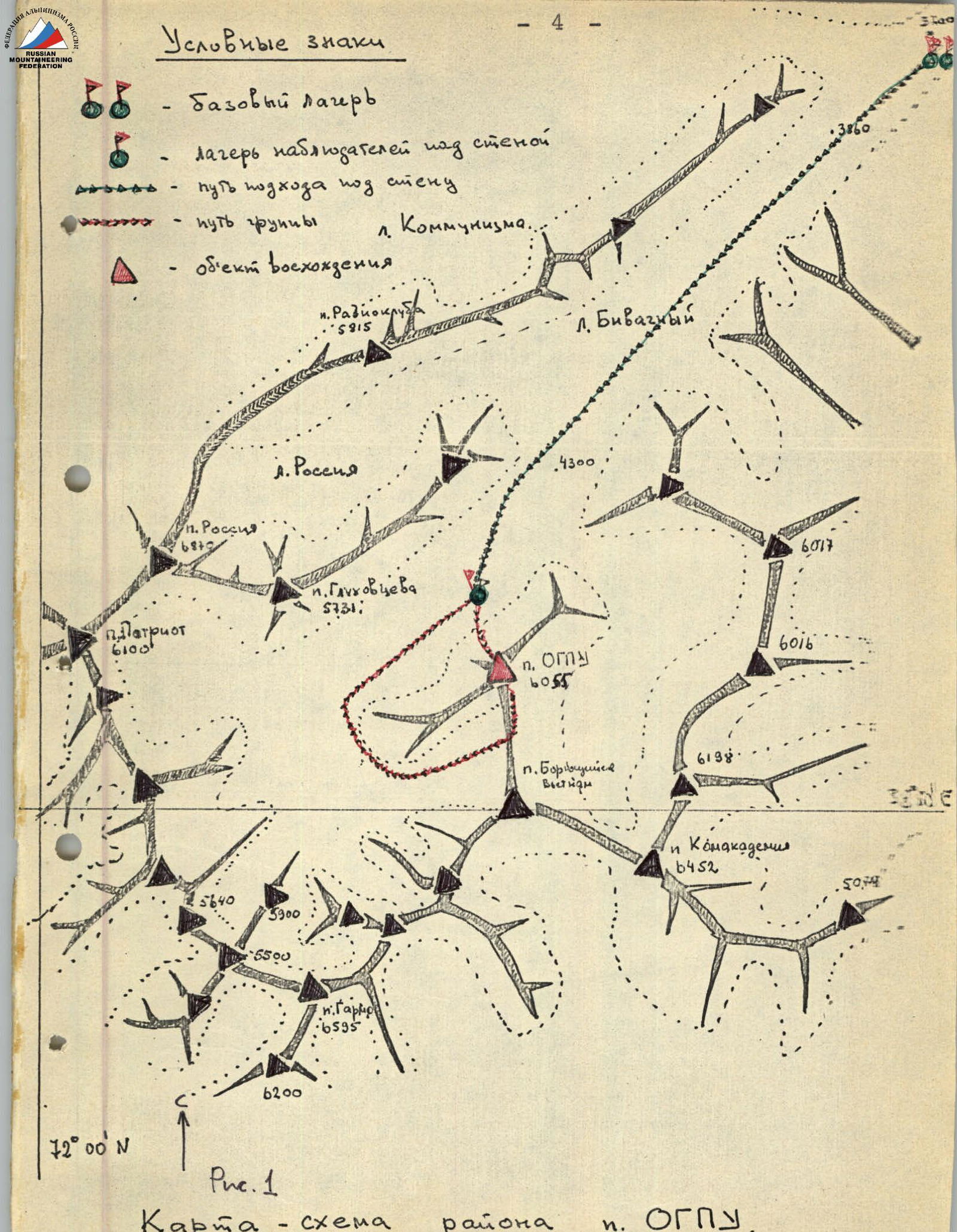 Conventional signs:
- Base camp
- Observer camp above the wall
- Path to the wall
- Path of the Peak Kommunizma group
- Object of ascent:
- p. Radioklub 5815
- l. Bivachny
- p. Russia 6849
- p. Glukhovtseva 5731
- p. OGPU 6055
- p. Borujn Vietnam 5700
- p. Komakademiya 6452
- p. Garmo 6595
- Fig. 1. Map-scheme of the area around p. OGPU.
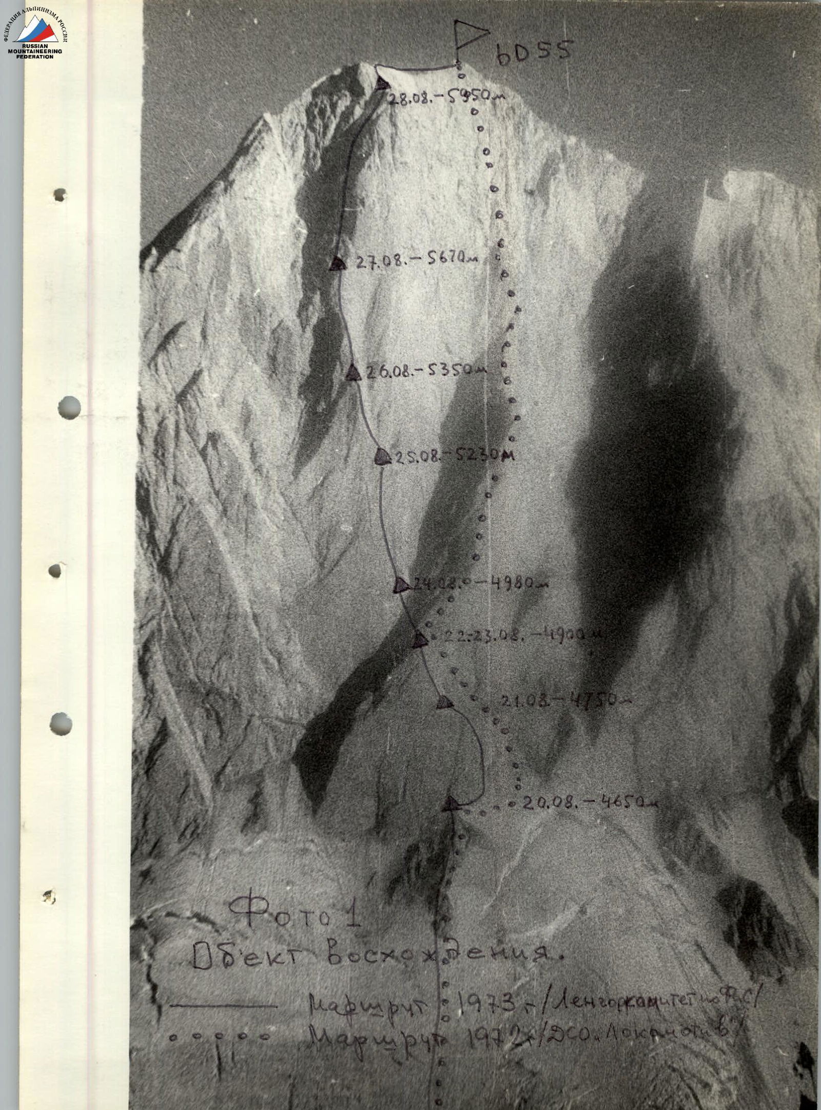 Photo 1. Object of ascent.
Route: 1973 - Leningrad Committee for Physical Education and Sports.
Route: 1972 - DSO "Lokomotiv".
Photo 1. Object of ascent.
Route: 1973 - Leningrad Committee for Physical Education and Sports.
Route: 1972 - DSO "Lokomotiv".
Team Composition, Climber Characteristics, Preparation, and Tactical Ascent Plan.
Assault Group:
| Name | Sports Qualification | Climber Characteristics |
|---|---|---|
| SHEVCHENKO Y.S. Deputy captain | MS | Participant in 12 first ascents of the highest category; USSR champion in 1971, prize-winner in USSR championships in 1962, 1964, 1968. |
| NOSOV A.P. | CMS | Participant in 3 ascents of category 6 difficulty, prize-winner in USSR championship in 1968, multiple champion of Leningrad. |
| SMIRNOV A.A. | CMS | Participant in an ascent on p. Borkhona of category 6 difficulty, prize-winner in Leningrad championship. |
| POSESSOR L.V. | CMS | Participant in an ascent on p. Borkhona of category 6 difficulty, prize-winner in Leningrad championships. |
Observation and Support Group:
| № | Name | Sports Qualification | Position |
|---|---|---|---|
| 1. | REKEDA A.A. | CMS | Group leader |
| 2. | POLYAKOV D.A. | CMS | participant |
| 3. | SHIMELIS V.P. | CMS | participant |
| 4. | KURITSYN I.F. | CMS | participant |
| 5. | CHASOV E.I. | CMS | participant |
| 6. | LAZAREV V.I. | CMS | participant |
| 7. | VANKOV D.E. | doctor |
Team coach and captain - Honored Coach of the RSFSR, Master of Sports G.A. Chunovkin.
On August 14, the team arrived in the village of Darut-Kurgan in the Alay valley. Prior to that, they had been conducting search operations on the slopes of Peak Lenin for a month, attempting to locate the body of a tourist who had perished in 1972.
After acclimatization and reconnaissance, the team twice ascended from the Aчик-Tash valley to the "occupied" height of 7000 m to inspect and probe sections of the slopes of Peak Lenin. Naturally, all team members gained excellent physical fitness and were well-acclimatized. To maintain their fitness during rest days, they played football daily (at a base camp altitude of 3700 m!), including matches with GDR teams and the "Burevestnik" expedition. During this period, they also conducted 7 training sessions on the rocks to the right of the "Lukovaia Poliana," aiming to refine their teamwork and interaction.
It is worth noting that the team's preparation was strictly planned:
- From January to April 1973, 52 training sessions were conducted, excluding individual training.
- In May, a team training camp was held in the Crimean mountains.
- 14 people participated in 15 ascents on arrays such as Demerdzhi, Angara-Burun, Kush-Kaya, etc.
- Routes were selected based on the expected nature of the rocks on the designated objectives. The most suitable routes were on the destroyed, heavily weathered walls of Demerdzhi.
- One-third of the registered participants actively trained in mid-altitude areas in the second half of May, passing exams at an instructor school.
On August 17, the team was helicoptered to the Bivachny glacier, and the next day, after a tiring 8-hour trek across the glacier, they ascended to a camp on the median moraine opposite the northwest wall of Peak OGPU. The team's efforts were somewhat eased by the helicopter, which allowed them to:
- Conduct a visual reconnaissance of the upper part of the wall.
- Make a small delivery (60 kg) of food and equipment to the glacier.
From the median moraine of the Bivachny glacier, where the observation camp was set up, the wall is fully visible.
On August 18, the team conducted a detailed visual reconnaissance using optical instruments from various angles, including from the opposite slope of the ridge.
Additionally, one group:
- Found and marked a passage through the glacier to the wall.
- Determined that the lower 400 m of the wall consists of pure ice, with some areas being hanging ice.
All groups noted frequent rockfalls from the "throat" area (where the two main couloirs converge, bounding the wall on the right and left).
Although they had a good understanding of the area from numerous photographs and consultations, the northwest wall of Peak OGPU still impressed them. Despite being relatively lower than the surrounding giants (Peak Kommunizma, Peak Russia, etc.), the sheer 1700-meter wall, composed of light marble, is mesmerizing and seems unconquerable. It is immediately apparent that, although the previously ascended routes on the northwest wall are worthy, the chosen path could more radically resolve the problem of sporting exploration of the massif.
During observations, no rockfalls were registered along the center of the wall. It was also found that the wall is sunlit only from 13:30 to approximately 17-18 hours, as clouds often gather in the area of Peak Kommunizma and Peak Russia by the end of the day, blocking the setting sun. Therefore, on a route of such complexity, there was no hope for an early start and productive work during this time due to the cold.
It was also discovered that for most of the wall, and certainly in the middle section, there are no visible snow or ice sections, so the team had to consider the possibility of carrying water during the ascent. The absence of visible bivouac sites, except for a scree ledge in the lower part of the wall and a snowy slope slightly to the left of the upper rock tower, was also a concern.
After discussing the reconnaissance data, the team planned the ascent route, which would cross the ice slope, pass through a rock island to the right of the "throat," and then follow almost the direttissima to the rock tower, capturing the center of the wall. For convenience, the route was divided into sections:
- Ice slope.
- Lower rock section of the wall (up to the intersection with the right couloir).
- Middle section of the wall.
- Ascent up the rock tower to the ridge.
- Summit ridge.
The plan was to ascend the wall in 8-10 days (depending on weather conditions) and descend towards Peak "Borujn Vietnam" via a simple route, exiting onto the Bivachny glacier. This plan was executed by the team without deviation.
The team composition, approved by the coaching council, initially included 5 people:
- SHEVCHENKO Y.S. - ascent leader, deputy team captain, doctor.
- NOSOV A.P. - participant.
- SMIRNOV A.A. - participant.
- POSESSOR L.V. - participant.
- KURITSYN I.F. - participant.
However, due to severe gastrointestinal issues on the day of departure, I. Kuritsyn was unable to participate in the ascent, and by decision of the release officer and ascent leader, he was included in the observation group. Captain and team coach G. Chunovkin did not participate in the ascent due to illness, as advised by doctor D. Vankov. All participants in the assault group were from the list registered for the Championship.
The team and observation group maintained radio contact (VHF radios) at 8:00, 14:00, and 20:00. For emergency signaling, the team was also equipped with flares. The highly qualified observation and support group, in addition to the radio station, had a 30-60x spotting scope and could observe the climbers in detail.

Ascent Description
August 20 - At 12:00, the team left the observation camp on the median moraine of the Bivachny glacier. They crossed the glacier (following the pre-scouted and marked path) and then, using front-pointing techniques with piton protection, overcame a 400-meter slope of pure ice with a gradient of 40-45°. At this time, the slope was not yet sunlit, and it was cold. After traversing approximately 2.5 ropes through loose slopes in the lower island, the group stopped for a bivouac at 17:00, setting up a platform about 20 meters from the wall. The weather was clear, light wind, though cold, and the group spent the rest of the day examining the lower part of the wall and resting.
August 21 - The working day for the first rope team, Posessor-Nosov, began at 9:00. Their path went under the wall and then along the ice, following the wall to the right, into an internal angle that led upwards (sections R2-R3, R3-R4). Upon closer inspection, the wall proved more challenging than initially thought. The team employed a full arsenal of pitons (mainly wide, combined ones) and ladders. Progress was slow due to the combination of overhanging sections, internal angles with fragile rock, and "live" blocks, which required significant time to choose a path, determine a safe method of overcoming it, and find a suitable spot to place a piton. Often, a piton that seemed secure upon placement would become unreliable minutes later as the crack widened.
The 50-meter internal angle with an average gradient of 90-95° (section R3-R4) led left onto a ledge suitable for belaying. Here, they left the 1st control cairn. From section R3-R4 onwards, the rope teams used double ropes, except for a few short sections. At the end of section R3-R4, the exit to the ledge was blocked by overhanging rocks, and "live" stones could be dislodged by the rope.
The team then overcame another 2 ropes of very difficult rock with unstable boulders and slabs. Protection was provided by pitons, with repeated use of artificial holds (sections R3-R5 and R5-R6). Upon reaching the scree ledge (R6-R7), the rope team organized the hauling of a specially made bag-backpack. They also set up two narrow platforms for tents on the ledge. Besides the "Pamirka" tent, they had a small two-person tent.
August 22 - The Shevchenko-Nosov rope team departed at 9:00. After traversing 20 meters of the ledge with increasingly steep rock, they turned left towards a wall with narrow ledges (section R7-R8). The ledges, littered with "live" stones, were interrupted by 6-10 meter walls with gradients of 80-100°, i.e., overhanging. Overcoming these was challenging due to the weathered marble (thin slabs), making it difficult to place reliable pitons. After 100 meters of movement along the wall, they reached a broad ridge to the right of the couloir. Here, under the protection of a wall, they set up a platform for the "Pamirka" tent.
The team encountered sections that caused concern, particularly the crossing of the couloir (sections R8-R9 and R9-R10). Therefore, while Smirnov-Posessor prepared the platform, the other rope team traversed the relatively easy rock on the right wall of the couloir (80 meters, 50°). After considering several options, they chose a path that crossed the couloir where a deep, protected niche was located on the opposite side. This niche, with a horizontal base, could safely accommodate two people, making it the only safe crossing point.
The opposite slope of the couloir was formidable - an overhanging wall that required careful navigation. A 25-meter horizontal traverse along a 50° slope led to one of the particularly complex, key overhanging sections (R10-R11). Movement here began with a difficult traverse left and upwards on étriers (5 meters), frequently using étrier holds (Zayl'Pug). Further ascent was up a gradually flattening wall (110-80°), with pitons placed in a single crack. "Korob" pitons and ice screws were used. After 10 meters, the path became somewhat easier, with an exit left from under the overhang. The team worked until dusk (10 hours).
August 23 - Faced with a daunting 250-meter, clearly negative wall, the team decided to process as much of the section as possible to pass it confidently and with less effort. On this day, they processed the path from sections R11-R12 to R14-R15. In the brief chronicle of the ascent, only the most challenging and interesting moments are highlighted. Section R12-R13 presented a smooth internal angle transitioning into a cornice, partially broken by a 40-50 cm gap. Due to the lack of cracks for piton placement, a bolt piton was used in the lower part of the angle. After passing this section, it became clear that going straight up would not be successful due to smooth walls requiring extensive bolting. The "processors," Nosov-Shevchenko, made a 15-meter traverse to the right along very steep (85°) walls with tiny ledges onto a rock "patch," from which they descended 5 meters "dülfer" to the other side of the ridge (section R13-R14). The use of "vibram" boots was challenging on these difficult rocks, and they longed for "trikoni" boots. Much time was spent on the vast internal angle (section R14-R15) with two overhangs. Only with great effort did Posessor manage to pass it by 19:00 and secure the rope at the top. The entire path was traversed using ladders. The smooth walls of the angle, overhangs, and lack of piton placement sites made it an extremely challenging test.
The group descended and bivouacked at the previous site. The working day lasted 11 hours.
August 24 - As on previous days, the weather was sunny, but at an altitude of 5000 m and above, it was relatively warm only from 14:00 to 17-18:00 when the sun was shining on them. However, the rocks seemed not to warm up even in the sun.
The team followed the processed path, passed section R8-R9, safely crossed the couloir, and ascended the negative wall using étriers and jumar clamps, stopping at the end of section R10-R11 under a protective overhanging rock to set up a safe and sufficient platform for four.
Fortunately, they found about 4 kg of ice in a deep crevice.
The hauling of backpacks was done through the couloir onto a small ledge approximately in the middle of section R10-R11.
On the same day, Nosov-Shevchenko passed the extremely difficult 2.5 ropes: sections R15-R16 – R18-R19. The нависающие стены и неудобные расщелины, перекрытые карнизами, напоминающие песчаник, поверхности отвесов, чередующиеся с черепичным строением — всё это преодолевалось сложным лазанием, ибо нередко из-за отсутствия мест забивки надёжных крючьев искусственные точки опоры не всегда можно было применять. К концу рабочего дня предельно уставшие, мы смогли, наконец, убедиться, что эту часть стены можно считать пройденной. Продолжительность рабочего дня — 11 ч.
На биваке оставлен контрольный тур № 2.
August 25 - In clear but windy and cold weather, the team ascended to the ledges above section R18-R19 along the processed path. The challenging 270 meters, even without backpacks (which were hauled along the fixed ropes), were not easy. After creating a small platform, they found an absence of snow or ice around. That evening, they had to make do with the remaining water from the previous bivouac (0.5 liters).
August 26 - In the morning, 80 meters from their overnight spot, they found ice. The rope team fetched it using pitons. Since the backpacks were significantly lighter by this day, they decided to abandon hauling the bag-backpack and redistribute the load. The first climber led the way with a 3-4 kg backpack, while the others, using jumar clamps for ascent, carried no more than 12-15 kg.
Section R19-R20 was deemed easier due to the destroyed state of the rock ridge, requiring caution and careful choice of handholds. However, after 40 meters, the steepness of the rocks increased to 60°. A vertical wall with ledges followed, with difficulties in navigating around overhanging sections. Starting from section R21-R22, the team encountered extremely difficult rocks again, requiring not only preparation but also experience and patience. The vertical wall was covered with thin rock flakes, resembling sandstone. The reliability of piton placements was always in doubt. They successfully created small steps with a hammer. Large combined pitons, wedges, and "korob" pitons were used, with occasional placements of ice screws directly into the rock. Two cornices with 1.5-2 meter overhangs were overcome "head-on." Unfortunately, due to camera malfunction, they could not document the most interesting fragments of the ascent.
At the end of section R21-R22, they unexpectedly found a platform and set up a tent as night fell, with an even more challenging wall ahead. Here, they left control cairn № 3.
August 27 - The next rock section (R22-R23) was a steep (80°) wall with eroded marble surfaces, making it extremely difficult to climb. Combined with the impossibility of placing reliable pitons, the cold, and strong wind, this section was very challenging. The team spent 3 hours on just 40 meters. The structure of the rock surface on section R23-R24 was similar to the previous one, but the difficulties were compounded by a diagonal cornice with a 1-meter overhang. They continued using double ropes and frequent artificial holds. After reaching the western side, the path became somewhat easier, with weathered slabs and walls appearing. At one point on section R24–R25, they could even set up a semi-reclined bivouac. Beyond this section, they approached a steep, snowy ledge turning left. As setting up a platform was impossible, they descended 30 meters down to organize a sitting bivouac. The night was windy, with snowfall.
August 28 - The cold and discomfort of the sitting bivouac prompted the team to rise at dawn. By 7:30, the first rope team, Nosov-Shevchenko, was working on the route.
They decided to ascend the northeast side of the rock tower, whose grandeur and difficulty were apparent from both the visual reconnaissance below and during the ascent. A direct "head-on" approach was complicated by a band of cornices and the "scaly" surface. However, the chosen path proved equally challenging.
By the end of August, this part of the route was not sunlit. The ice had filled most cracks, and the overnight snow covered handholds and cracks. The team, however, had extensive experience climbing such walls.
With A. Nosov leading, they methodically and calmly overcame the cold and challenges, passing:
- A traverse along a steep (60°) ledge to the left.
- A destroyed internal angle.
- A very difficult section of overhanging rocks and smooth vertical walls without cracks (sections R27-R28; R28-R29).
Gradually, they encountered more gentle but icy sections. The overall steepness remained (75-85°).
Finally, by 18:00, after overcoming a vertical 20-meter wall with an overhanging top (section R30-R31), where ladders were used, the group reached the rocks of the ridge character and stopped under the summit ridge for a bivouac after 90 meters.
August 29 - On the 10th day of the ascent, in very windy, cold, but clear weather, the team ascended to the summit of Peak OGPU via a relatively easy, destroyed ridge in about 2 hours. They found a note from O. Khudyakov's group (DSO "Lokomotiv") in the cairn. Without delay, they began descending along the very eroded rock ridge with small, difficult-to-navigate "gendarmeries" towards Peak "Borujn Vietnam." The destruction of the rocks posed a certain danger.
The path then led through calga-spurs reaching up to a person's height and numerous open and closed crevices to the Bivachny glacier, where the team returned to the observation camp by 19:00.
In conclusion, the ascent of Peak OGPU via the center of the northwest wall was noted for its difficulty, which cannot be fully evaluated by conventional alpinism criteria. The number of pitons used was lower than desired due to the unique, eroded, and highly polymorphous nature of the marble rocks. This characteristic demanded that climbers choose the optimal method for overcoming each section without error.
Most complex sections were traversed using free climbing, with artificial holds used sparingly. Three bolt pitons were placed for belaying.
The tactical plan's strength lay in utilizing all favorable bivouac sites while completing the challenging route within a tight timeframe. The team's success was attributed not only to their thorough preparation in 1973 but also to their collective experience in complex ascents, such as on Peak Borkhona in 1972.
The participants in this very difficult ascent, striving to mark the 50th anniversary of Soviet alpinism, demonstrated their best qualities: mastery, mutual aid, and collectivism.
A detailed technical description of the route is provided in the "Table." According to the team and its coach, the combination of difficulties and the demands of the wall surpassed those encountered on the northeast wall of Peak Engels, ascended by the team's coach and ascent leader in 1971.
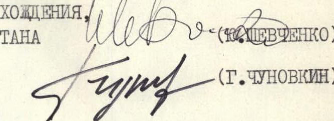 Ascent leader, deputy captain (Yu. Shevchenko)
Team coach (G. Chunovkin)
Ascent leader, deputy captain (Yu. Shevchenko)
Team coach (G. Chunovkin)
Table of Main Route Characteristics
Ascent route - Peak OGPU (6055 m) via the center of the NW wall. Height difference - 1750 m (summit 6055 m, glacier 4300 m). Total route length - 2045 m. Length of most complex sections - 1495 m (particularly complex - 1200 m). Length of sections with backpack hauling - 865 m. Average steepness of the wall along the ascent path from the base of the lower bastion to the ridge - 83°. Average steepness of the route from the base of the lower bastion to the ridge - 73°.
Table 1. Main Characteristics of the Ascent Route
| Date (August 1973) | Sections Passed | Section Length (m) | Average Steepness (deg.) | Terrain Characteristics | Technical Difficulty | Method of Overcoming and Belaying | Weather Conditions | Bivouac Time | Exit Time | Working Hours | Rock Pitons | Ice Pitons | Bolt Pitons | Backpack Hauling (m) | Bivouac Conditions | Daily Ration Weight |
|---|---|---|---|---|---|---|---|---|---|---|---|---|---|---|---|---|
| 20 | R1 | 400 | 40 | Ice | Broad ice slope, snow-free. местами ostровки скал с натёчным льдом | Front-pointing in crampons with piton protection | Clear, cold. | 17:00 | 12:00 | 5 | 3 | – | – | – | Tent for 4 people | 0.4 kg per person |
| R2–R3 | 30 | 30 | Ice | Ice slope along the rock wall | Belay on rock outcrops. Movement without crampons | Clear, cold. | – | – | – | – | ||||||
| R3–R4 | 50 | 90–95 | Rocks of extreme difficulty | Internal ledge leading to a narrow platform suitable for belaying and changeover | Belay by the leader on a double rope | 18 | – | – | – | |||||||
| Exit to the ledge blocked by overhanging rocks. Rocks very destroyed and fragile | ||||||||||||||||
| R4–R5 | 40 | 85–90 | Rocks of extreme difficulty | Vertical slab covered with thin flaking slabs "shell" | Belay similar to section R3–R4 | 11 | – | – | – | |||||||
| R5–R6 | 40 | 90 | Rocks of extreme difficulty | Internal angle closed at the top by overhanging unstable boulders | Use of ladders | 12 | – | – | – | |||||||
| R6–R7 | 30 | 15–30 | Simple rocks | Wide scree rock ledge. Rockfall area protected by rocks. Can set up a platform for a 2-person tent. | Variable belay, pitons | 2 | – | – | – | |||||||
| 22 | R7–R8 | 100 | 70–80 | Difficult rocks | Alternating narrow ledges and rock walls. Ledges very destroyed and littered with large unstable stones. | Belay by the leader on a double rope through pitons. Others follow perils with jumar clamps. | Clear, cold. | 18 | Bivouac on the ledge after section R7–R8 | 60 m hauling of bags | ||||||
| R8–R9 | 80 | 50 | Rocks of medium difficulty | Rocks on the main couloir wall. Rocks smoothed by water flows and scarred by rockfalls. Rockfall hazard. | Belay through pitons. Ropes. Movement with observer between rockfalls. | Clear, cold. | 5 | – | – | – | – | |||||
| R9–R10 | 25 | 50 | Rocks of medium difficulty | Horizontal traverse through the couloir under the wall. Orienting landmark - a deep niche in the overhanging rocks. | Belay through pitons. Ropes. Movement with observer between rockfalls. | Clear, cold. | 9 | – | – | – | – | |||||
| R10–R11 | 35 | 110 | Rocks of extreme difficulty | Overhanging wall of gray monolithic blocks leading to a narrow ledge under an overhanging rock. | Belay on a double rope. Ascent on ladders. Use of étrier holds (Zayl'Pug). | Clear, cold. | 19 | 9 | 19 | 12 | – | Bivouac under the wall on the ridge to the right of the couloir | ||||
| 23 | R11–R12 | 40 | 75 | Very difficult rocks | Marble slabs with weathered surfaces. Holds very fragile. Pitons hold poorly. | Belay through pitons | Clear, cold. | 8 | 1 | – | – | – | ||||
| R12–R13 | 40 | 75 | Extremely complex rocks | Internal angle formed on the right by slabs, on the left by overhanging rocks. Cornice with 1.5 m overhang. | Belay on a double rope. Use of artificial holds. | Clear, cold. | 14 | 1 | – | – | – | |||||
| R13–R14 | 15 | 85 | Very difficult rocks | Horizontal traverse right along a vertical wall under a cornice onto a rock "patch" and descent 5 m down. | Belay through pitons on a double rope. Use of artificial holds. Hauling backpacks. | Clear, cold. | 3 | |||||||||
| R14–R15 | 50 | 80–96 | Rocks of extreme complexity | Huge internal angle with two overhanging sections. Leads to a convenient belay platform. | Double rope. Artificial holds. Hauling backpacks. | Clear, cold. | 20 | 1 | – | – | – | Bivouac on the previous site | Poor water supply for drinking | |||
| 24 | R15–R16 | 55 | 95–100 | Rocks of extreme complexity | Overhanging wall with a crack. Crack overlapped by two cornices. Leads to a small square platform. | Double rope. Use of artificial holds. Zayl'Pug. Cornices very destroyed, pitons hold poorly. | Clear, cold. | 28 | 3 | – | – | – | Bivouac under an overhanging rock above section R10–R11 | 40 m to section R10–R11 couloir | ||
| R16–R17 | 10 | 80 | Very complex rocks | Smooth wall with a weathered surface resembling sandstone | Free climbing. Holds very fragile | Clear, cold, wind. | 4 | 1 | – | – | – | |||||
| R17–R18 | 20 | 30 | Complex rocks | Horizontal traverse along slopes under an overhanging wall. Leads to the junction of the western and northern faces. | Free climbing. | Clear, cold, wind. | 2 | |||||||||
| R18–R19 | 40 | 75 | Complex rocks | Tiled slabs. Rockfall hazard! Leads to a scree ledge where a platform can be made. | Free climbing using friction. | Clear, cold, wind. | 3 | Shuttling 80 m with a bag | ||||||||
| 25 | Bivouac under an overhanging rock above section R10–R11 | Clear, cold, wind. | 20 | 9 | 11 | – | 270 m along the fixed ropes | 4 people in a "Pamirka" tent | 0.4 kg per person | |||||||
| 26 | R19–R20 | 40 | 45 | Rocks of medium difficulty | Broad destroyed rock ridge | Simultaneous movement | Clear, cold, wind. | 2 | ||||||||
| R20–R21 | 20 | 60 | Complex rocks | Narrow ledge along a vertical wall with two overhanging sections. | Simultaneous movement, belay through pitons | Clear, cold, wind. | 4 | 1 |