Climbing Route Description
in the Central Pamir region on peak Krasnoarmeitsev (conditional name), peak 4710 m, via the Southwest Counterfort, via route 3A category of difficulty (approximately) by the group of LGS DSO "Spartak" gathering:
team leader Razumov Yu.M. — 1st sports category, Vostrova I.A. — 1st sports category, Baybara V.S. — 2nd sports category, Sayfutdinov R.L. — 2nd sports category (Osh city, "Spartak").
1974
Brief Geographical Description of the Climbing Area
Central Pamir — bounded to the north by the Muksou river (below Surkhob), and to the south by Bartang (above Kudara). To the east, the Zulumart ridge serves as the boundary, and to the west — the western spurs of the ridges Petra Pervogo and Darvazsky, as well as the large bend of the Pyanj river near Khorog.
Central Pamir is a concentration of high ridges, powerful glaciers, and giant peaks.
Most ridges have a latitudinal direction. The northernmost of them is the ridge Petra Pervogo. To the south lies the Darvazsky ridge, bearing peaks:
- peak Garmo — 6595 m
- Arnaval — 6083 m
The base area of the alpinist camp "Vysochnik", through which the participants of the LGS DSO "Spartak" gathering arrived in Central Pamir, was located in the upper reaches of the Vanch valley. The Vanch valley is bounded:
- to the north — by the Darvazsky ridge
- to the south — by the Vanchsky ridge
For the first time, the topographic survey of the area was carried out by N.G. Dorofeev in 1928, who reached the Geographical Society glacier from the Fedchenko glacier.
A more detailed survey of the area was conducted in 1949 by a group of topographers and glaciologists led by R.L. Zabirov.
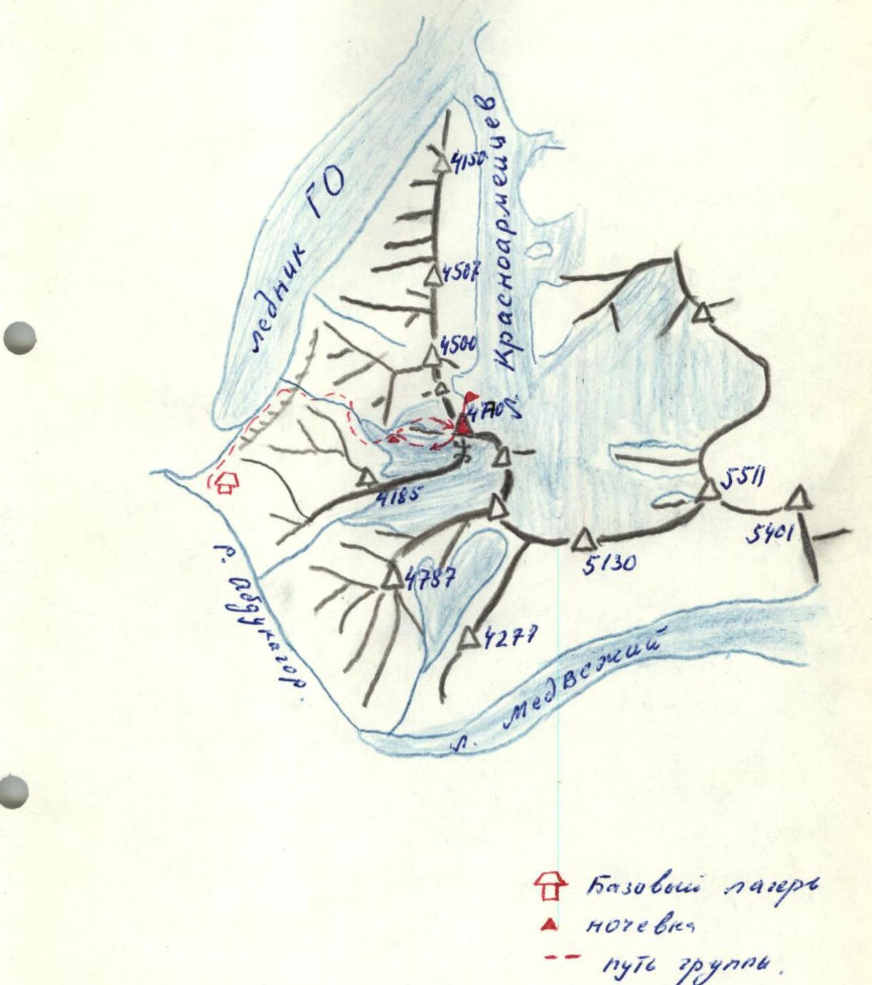
The Vanch valley is closed at the top by a spur of the Academy of Sciences ridge, separating the GO glacier from the Krasnoarmeitsev glacier. The highest point of the spur is peak 4710 m, which we chose as the object of our training ascent.
Climbing Conditions in the Area
From the base of a/l "Vysochnik", located in Osh city, we traveled by car for three days to the base camp, which was set up near the tongue of the Geographical Society glacier.
Most routes in the area are combined snow-rock. There is a lot of ice. The ice is firm and not soggy. The peaks are composed of heavily destroyed rocks, with many "loose" stones.
The weather was not favorable — we had to make ascents in fog and strong wind.
The path from the base camp, located near the tongue of the GO glacier, goes along a trail on the right (in the direction of travel) bank of the glacier to the first stream flowing in from the right (1 hour). Ascend along the right bank of the stream. Before reaching the waterfall, cross to the left bank and ascend 100 m up a side stream. Then, bypass the waterfall on the left. After the waterfall, continue ascending along the left bank. 200–300 m before reaching the glacier tongue, cross to the right bank and follow a stream flowing into it, then along the scree and moraine ridge, bypassing the glacier on the right.
Cross the glacier at its least crevassed section. This is a convenient spot for an overnight stay (7 hours).
Ascent Description
From the overnight stay on the glacier tongue, ascend left up the green moraine ridge and then along scree, bypassing the hanging glacier on the right (in the direction of travel). Continue along snow along the right bank of the glacier to two counterforts ending in destroyed rock walls. Section R0–R1 takes 1 hour 30 minutes.
Ascend via a snow-scree couloir between the counterforts to the shoulder of the left counterfort, above the rock wall, and move up it to a gendarme. Bypass the gendarme on the right via snow, then 100 m under a snow slope. Section R1–R2 is 500 m long and takes 1 hour. Movement is simultaneous, without ropes. At the end of the section, there is a control cairn.
From the cairn, ascend up a steep snow-ice slope in the direction of the saddle between the peak to the right and the gendarme to the left. Initially, movement is simultaneous, then:
- 80 m of ice covered with a thin layer of snow are traversed on crampons with occasional belays.
From the ice, reach a rock outcrop ("loose" stones) and ascend via it to the saddle. (Section R2–R3). Length 400 m — 2 hours.
From the saddle, a steep snow-ice ridge leads to the peak on the right (Cornice!!). Ascend below the ridge via ice. Belays via ice screws. Reach the summit via snowy rocks. Section R3–R4 is 100 m long, with an average steepness of 45°, and takes 1 hour.
Descent via the summit. Initially, a 25 m rappel, then down a couloir, 200 m of sporty descent using the rocky, heavily destroyed walls of the couloir for piton placement. Then descend via scree and snow to the glacier and from there to the overnight stay (3 hours).
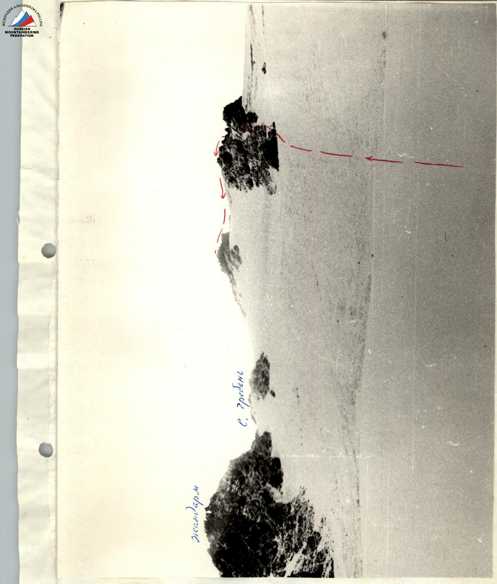
Fig. 2. Pre-summit snow-ice ascent, sections R2–R3 and R3–R4. Ascent route: Southwest Counterfort of peak Krasnoarmeitsev (conditional name), peak 4710 m, 3A category of difficulty (approximately).
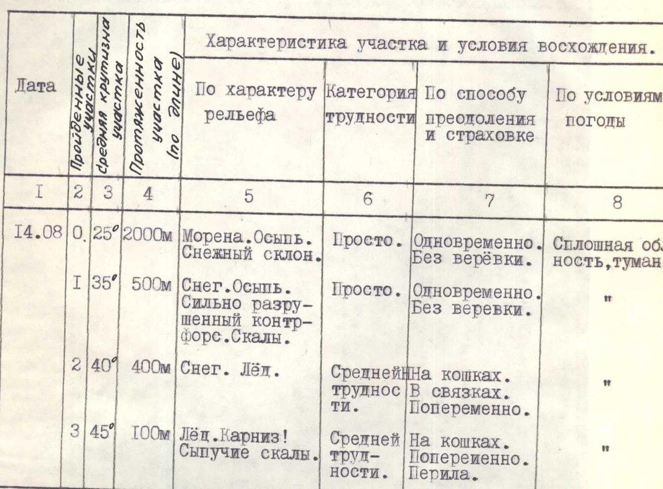
Table of Main Characteristics of the Ascent Route
Ascent route: Southwest Counterfort of peak Krasnoarmeitsev (conditional name), peak 4710 m, 3A category of difficulty (approximately).
| Date | Section | Steepness | Length | Relief Characteristics | Category of Difficulty | Method of Overcoming | Weather Conditions | Time (moving/stopping) | Pitons (rock) | Pitons (ice) | Pitons (bolted) | Weather Conditions |
|---|---|---|---|---|---|---|---|---|---|---|---|---|
| 14.08 | R0 | 25° | 2000 m | Moraine. Scree. Snow slope. | Easy. | Simultaneously. Without rope. | Continuous cloud cover, fog. | Departure at 7:00. 1.5 hours. | ||||
| R1 | 35° | 500 m | Snow. Scree. Heavily destroyed counterfort. Rocks. | Easy. | Simultaneously. Without rope. | 1 hour. | ||||||
| R2 | 40° | 400 m | Snow. Ice. | Medium difficulty. | On crampons. In teams. Alternating. | 2 hours. | 6 | |||||
| R3 | 45° | 100 m | Ice. Cornice! Loose rocks. | Medium difficulty. | On crampons. Alternating. Rappel. | 1 hour. | 2 | 3 |
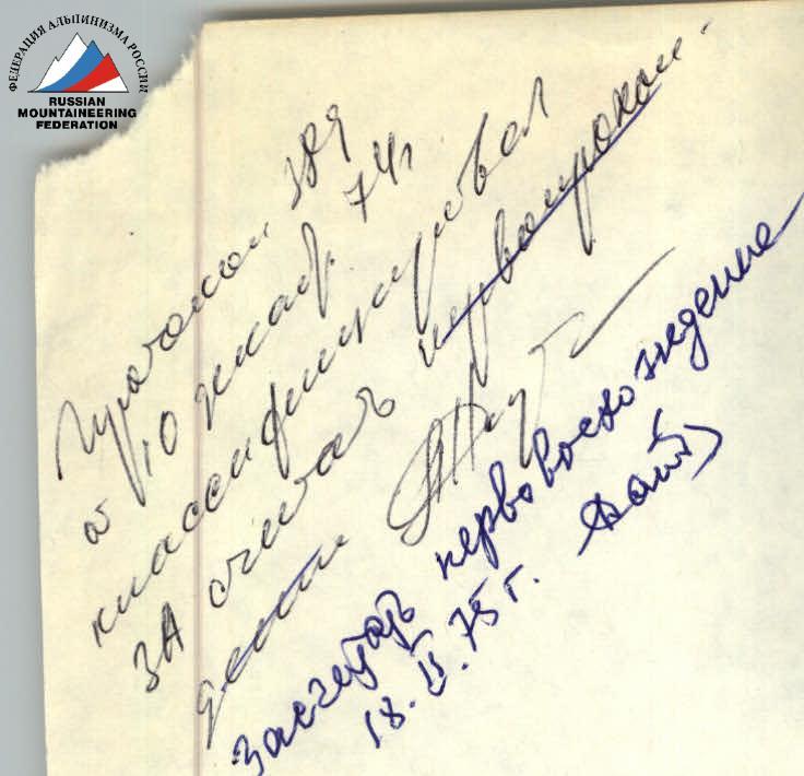
Team Leader
 (Razumov Yu.M.)
Coach (Kolchin A.A.)