USSR ALPINISM FEDERATION Central Council of the SDSO "Burevestnik", Bauman MSTU sports club
Ascent to Peak Evgenia Korzhenevskaya (7105 m) via South Face of the Pamir Mountains. (Report)
Team Coach A. Ovchinnikov Team Captain L. Dobrovolsky
Fortambek Glacier — Moscow, 1966
 www.alpfederation.ru↗
I. Brief Geographical Description, Exploration, and History of Ascent to Peak Evgenia Korzhenevskaya
Peak E. Korzhenevskaya was discovered and mapped by the renowned explorer of Central Asian mountain regions, geographer, and glaciologist N. A. Korzhenevsky in 1910.
The main orographic features of the mountain node of Peak Evgenia Korzhenevskaya were resolved together with the enigma of the Garmo node in 1932 by the teams of the Tajik Expedition of the USSR Academy of Sciences, which included N. V. Krylenko. The teams of climbers and surveyors explored the Fortambek and Mushketov glaciers, visited their tributaries, and determined that Peak Evgenia Korzhenevskaya is located in the northwest spur of the Academy of Sciences Range near Peak Kommunizma (the distance between them is 13 km). The height of Peak E. Korzhenevskaya was determined to be 7105 m.
In 1937, an attempt was made to conquer the peak. One of the three teams of the Pamir Expedition of the All-Union Council for Physical Culture and Sports, led by A. F. Getye, set out to ascend the peak via the northwest ridge. The attempt was unsuccessful.
Due to the remoteness and inaccessibility of the region, it was only possible to organize an expedition to storm the peak 16 years later. In 1953, a team of the Pamir Expedition of the All-Union Central Council of Trade Unions successfully ascended Peak Evgenia Korzhenevskaya under the leadership of Ugarov A. S. This was a significant achievement for Soviet mountaineering.
In 1961, participants of the "Trud" Society expedition attempted to storm the peak via one of the southern ridges. The attempt was successful, and people ascended this seven-thousander for the second time. In his memoirs about this region, expedition participant M. A. Greshiev wrote: "Its (Peak Evgenia Korzhenevskaya's) southern slopes drop off in kilometer-high walls onto the Moskvina Glacier." It was these walls that interested a group of climbers from the Central Council of the SDSO "Burevestnik," who traveled to the region of Peak Evgenia Korzhenevskaya during the summer season of 1966.
II. Preparation and Organization of the Expedition. Reconnaissance
Preparation of the participants for the planned ascent to Peak E. Korzhenevskaya began long before their departure to the mountains. Throughout the winter and autumn of 1965-1966, training sessions were conducted three times a week at the Bauman MSTU sports complex, as well as in Tsaritsyno and Khimki.
The training included:
- running on varied terrain,
- skiing,
- a set of exercises with weights to develop strength,
- sports games: football, basketball.
The overall training plan and standards were approved by the Central Council of the SDSO "Burevestnik." During the winter student holidays, a gathering of candidates for the expedition was held in the Elbrus region to prepare for high-altitude ascents. Two weeks before departing to the mountains, a check of the physical preparation of the participants for the planned ascent was conducted. All participants showed good results, exceeding the level of preparation in previous years. All participants had experience in joint ascents. Before departing to the mountains, available materials on the region of Peak E. Korzhenevskaya were thoroughly studied.
On July 14, the expedition participants arrived in the village of Lakhsh. Due to the lack of helicopters, all expedition participants gathered at the base camp only on July 26. On July 29, a group consisting of:
- Dobrovolsky L. N. — leader
- Ovchinnikov A. G. — coach
- Glukhov V. V. — participant
- Ivanov V. A.
- Masyukov V. P.
- Myslovsky E. V.
set out for acclimatization and reconnaissance to the region of the South Face of Peak Evgenia Korzhenevskaya. Night camps were organized at altitudes of 4900 m and 5075 m. As a result of the reconnaissance, the route of ascent to Peak E. Korzhenevskaya was finally chosen, and supplies and equipment were transported. Due to the objective danger of the South Face, it was decided to start the route via a counterfort that leads to the face and then to the South Ridge, which essentially becomes the pre-summit ridge at the point of exit.
The group returned to the base camp on August 1. On August 2 and 3, the group, for further acclimatization, made an ascent to Peak Four (6300 m).
On August 6, the group, consisting of: Dobrovolsky L. N. — leader, Ovchinnikov A. G. — coach, Arutyunyan R. A. — participant, Glukhov V. V., Ivanov V. A., Masyukov V. P., Myslovsky E. V., Tikhvinsky S. B., set out to ascend Peak E. Korzhenevskaya.
On August 7, the group reached the counterfort, which they began to ascend on August 8.
On August 10, at an altitude of 6500 m, Arutyunyan fell ill with tonsillitis, and the group was forced to begin descending to the base camp on August 11.
On the evening of August 12, the group was back at the base camp. Arutyunyan's condition was good. The expedition doctor provided medical assistance and monitored him.
After a day of rest, on August 14, the group, consisting of:
- Dobrovolsky L. N. — leader
- Ovchinnikov A. G. — coach
- Glukhov V. V. — participant
- Ivanov V. A.
- Masyukov V. P.
- Myslovsky E. V.
set out to ascend Peak Evgenia Korzhenevskaya.
III. Tactical Plan for the Ascent. Composition of the Assault Team
The tactical plan for the ascent was approved in accordance with the reconnaissance data and the first sortie.
Day 1 — departure to the night camp at an altitude of 5075 m.
Day 2 — departure to the counterfort. A cache was made at the beginning of the counterfort.
Days 3, 4, and 5 — passage of the counterfort of the southwest face and exit to the South Ridge.
Day 5 — ascent to the summit and descent back to the night camp.
Day 6 — descent to the base camp. The descent was planned to follow the South Ridge, along the route of the Tsetlin group, which by that time was at the base camp and provided detailed consultation on the descent route.
To ensure safety and quick organization of the descent down the counterfort in case of a return due to unfavorable weather, it was planned to leave a hook every 30 m for organizing the descent using the "sports" or "sitting on a rope" methods.
To reduce the weight of backpacks, the group planned to:
- use lightweight equipment made from light metals and alloys;
- pack food from high-calorie and concentrated products (at 600 g per person per day). Food was taken for 8 days.
After analyzing the first sortie, the assault team was approved in the following composition:
- Dobrovolsky L. N. — leader.
- Ovchinnikov A. G. — coach.
- Glukhov V. V. — participant.
- Ivanov V. A. — participant.
- Masyukov V. P. — participant.
- Myslovsky E. V. — participant.
The teams were formed in the following composition:
- Dobrovolsky, Glukhov;
- Ovchinnikov, Myslovsky;
- Masyukov, Ivanov.
Communication between the group and the base camp was carried out using rockets:
- One green rocket — "all is well";
- Two green rockets — the group has reached the South Ridge;
- Red rocket — distress signal.
IV. Passage of the Route
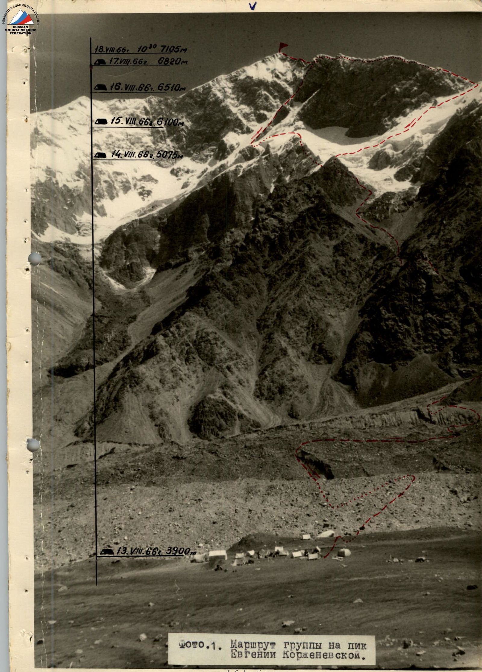
On August 14, 1966, at 7:00, a group of climbers from the Central Council of the SDSO "Burevestnik" expedition, led by L. N. Dobrovolsky, consisting of Glukhov V. V., Ivanov V. A., Masyukov V. P., Ovchinnikov A. G. (coach), and Myslovsky E. V., departed from the base camp located on the left-bank moraine of the Moskvina Glacier (camp altitude 3900 m) towards the foot of the South Face of Peak E. Korzhenevskaya. The weather was good, clear, with a slight morning frost. We descended from the steep moraine to the Moskvina Glacier and crossed it along a familiar path. The ascent and descent from the right-bank moraine presented no great difficulty, and after 1 hour and 10 minutes, having climbed up a gentle slope, we approached the waterfall. Here our route began. From here, we ascended to the ridge via "goat tracks" and rocks, some of which were covered in scree. We then turned right and continued up the ridge. Avoiding the peak of a gendarme, we traversed it on the left along a ledge above a steep couloir and then turned right onto a saddle in the ridge. From the saddle, we descended along scree-covered ledges to a stream. The path was straightforward from there to the beginning of the glacier flowing from under the South Ridge of Peak E. Korzhenevskaya. The slope and moraine had an average steepness of 35°.
Composition of the assault team of climbers from the Central Council of the SDSO "Burevestnik"
| # | Full Name | Party | Year | Rank | Number of notable ascents | Role in the group | Sports activities | Nationality | Home Address |
|---|---|---|---|---|---|---|---|---|---|
| 1 | Ovchinnikov Anatoly Georgievich | CPSU | 1927 | Master of Sports | 18: Peak Kommunizma, Dombay-Ulgen, Pti-dry | coach | skiing, athletics | Russian | Moscow, Krasnokholmskaya nab. d.1/15 kv.18 |
| 2 | Dobrovolsky Lev Nikolaevich | Komsomol | 1940 | Candidate for Master of Sports | 8: Dykh-Tau, Ushba, p. Shchurovskogo | assault leader | skiing, athletics | Russian | Moscow, Novokhoroshevskoe shosse, kv. 86, kor. 3, kv. 26 |
| 3 | Glukhov Vyacheslav Vasilievich | non-party | 1936 | 1st sports rank | 6: Ushba, p. Shchurovskogo | participant | skiing, athletics | Russian | Moscow, Aviamotornaya, d.1 |
| 4 | Ivanov Valentin Andreevich | Komsomol | 1941 | 1st sports rank | 5: Ushba, p. Shchurovskogo | participant | skiing, athletics | Russian | Moscow, Arbat 53, kv.3 |
| 5 | Masyukov Viktor Petrovich | Komsomol | 1937 | 1st sports rank | 5: Ushba, p. Shchurovskogo | participant | skiing, athletics | Russian | Moscow, ul. Aleksandra Nevskogo, d.8, kv.27 |
| 6 | Myslovsky Eduard Vikentievich | Komsomol | 1937 | Candidate for Master of Sports | 6: Dykh-Tau, p. Shchurovskogo, Ushba | participant | skiing, athletics | Ukrainian | Moscow, 2-ya Filevskaya, d.5 kv.22 |
We had to cross the stream several times. The tongue of the glacier was bypassed on the left. The first step of the glacier was traversed along the right-bank moraine, which was quite steep (40-45°). It was hard to walk, and our feet often slipped. The approach to the second step was straightforward along a medium scree slope with a steepness of 10°. Here were good places for camping. The second step of the glacier was bypassed on the left between a sheer rock wall and the ice along a steep firn slope with a steepness of up to 60°, covered with large vertical calga-spores. It took us 1 hour and 20 minutes of strenuous work to climb this steep "ladder." After the icefall, the glacier was calm. We walked along a small right-bank moraine. Not reaching 100 m to the third step of the glacier, we came to platforms where our two tents stood with some equipment and supplies. The time was 11:45. The next day was going to be a challenging one, so we needed to rest well, check our equipment, and supplies. At 20:30, we went for an evening walk. The weather was good. Below, clouds gathered. Right in front of us was Peak Kommunizma, illuminated by the setting sun. At 21:00, we went to bed. This was our last comfortable night. We slept three to a tent. We wouldn't have such luxury again.
On August 15, 1966, leaving both tents, one primus stove, unnecessary personal belongings, and some supplies for the return journey, we set out at 6:00 towards the beginning of the counterfort of the South Ridge. The weather was good. We put on crampons on the glacier.
Following the left side of the glacier, we traversed a straightforward snow-ice slope leading to the third step of the glacier. The icefall of the third step was bypassed on the left along a steep snow-ice slope. The ice was covered with a thin layer of snow (3-5 cm). It was easy to walk before the sun came out. The steepness was considerable (45°). We laid out small serpanines (at the beginning of August, during the reconnaissance sortie, this slope was much simpler: there was dense snow with natural step-like formations — calga-spores. Now almost all the snow had melted). After 1 hour and 30 minutes, we reached a "cushion" and a small plateau. Two glaciers fed from here. One flowed along the Western Ridge, and the other along the South Ridge of Peak E. Korzhenevskaya. From the "cushion," a magnificent panorama unfolded — Peak Izvestiy and Peak Kommunizma — Peak Kirova — Peak Leningrad, and so on, up to Peak Krupskaya.
The team led by Dobrovolsky L. and Glukhov V. went ahead, followed by Ovchinnikov A. G. and Myslovsky E. V., with Ivanov V. and Masyukov V. bringing up the rear. We had to overcome a challenging section — a steep hanging glacier. We traversed a gentle firn slope, constantly gaining altitude. We reached a steep section of the slope, which had to be passed before 11:00. After 12:00, the slope was fully exposed to the sun, and icicles and stones began to fall from above.
Passing the slope was facilitated by the fact that steps had been cut here during the previous sortie. Finally, the section ended, and we reached the counterfort.
Along a rock ledge sprinkled with small scree and "live" stones, we traversed to the ridge. The rocks were heavily destroyed. Insurance was hook-based. Here, on a platform cut into the firn and lined with stones, stood our high-altitude tent with a cache. The time was 12:00.
We decided to remove the tent and try to set up a bivouac higher. We redistributed the load among our backpacks, had a small snack, and continued upward in the same order.
The rocks were slate, heavily destroyed. We mainly used channel-shaped titanium and ice hooks.
Immediately after the platform, there was a very challenging section: a rock wall in the upper part was heavily destroyed. The first climber finally passed this section.
The path further was straightforward but dangerous. The rocks were heavily destroyed. We proceeded with extreme caution, sticking to the ridge.
To the right of the ridge, there were rockfalls up to 100 m high, and to the left, a steep snow-ice slope turned into a couloir.
Here, stones were constantly falling from the South Face and our counterfort. Therefore, the tempting path along the ice on the left of the counterfort was immediately ruled out.
The trailing team, Ivanov V. — Masyukov V., removed the hooks.
On the ridge, there were short challenging sections that had to be passed "head-on." There were few places to hammer in hooks: on destroyed sections, hooks held poorly, and on harder rocks, suitable cracks were scarce.
At 16:00, we approached a small wall. Climbing was challenging. The height and overall fatigue were taking their toll. Above the wall, there was a steep snowy ridge. The ridge was quite wide, and it was possible to cut out a platform for one tent.
At 17:00, we натянули перила, закрепили рюкзаки и принялись за работу. Площадку: — наполовину вырубаем, — наполовину выкладываем камнями.
By 19:30, the platform was ready. We set up the tent. "Квартирмейстер", Валя Иванов, разбирает рюкзаки, стелет 4-х спальный мешок, и через 10 мин все собираемся в палатке. Весело пыхтит «Фебус». Плотно ужинаем, пьём чай и вылезаем «на прогулку».
At 21:00, we fired a green rocket. From the base camp, we saw a response rocket that lit up somewhere below, in the approaching fog. By all signs, the weather was deteriorating.
We couldn't fall asleep for a long time — the altitude was taking its toll.
On August 16, 1966, we slept well. Our appetite was good. Acclimatization had done its job. In the morning, it was very cold. The counterfort was lit only at 11:30.
We left the bivouac at 10:00. Our feet were freezing.
We traversed a rock wall sprinkled with loose snow. We proceeded in the same order as the day before, with careful belaying. We passed a sharp snowy ridge and entered a steep (40°) snowy slope. Lev Dobrovolsky and Slava Glukhov struggled to pass it. The snow was very loose, and steps were forming poorly. The ice axe held poorly. Finally, the first team safely exited onto the rocks. The rocks were heavily destroyed. There were few handholds, and those that existed were unreliable and broke off under load. We had to proceed with a small gap between the teams to avoid being hit by accidentally falling stones. Some stones still managed to fall, despite our utmost caution. After passing 2.5 ropes, we reached a small platform. If necessary, we could have set up a sitting bivouac on this platform. After the platform, there was a steep (70°), very challenging wall. The first team was relieved by the second (Myslovsky E., Ovchinnikov A.). Again, the sound of hammering was heard. There were many handholds, but they were all unreliable — "live." The first team exited onto a ledge and moved right around a bend. Here began a very challenging section of rocks. The rocks were just as destroyed, but the steepness was much greater. In some places, the steepness reached 90°. Despite the fact that our backpacks were not very heavy, we still had to pull them up. Finally, we all exited onto the rock ridge. From time to time, there were sections of very loose snow. The ridge, although not very steep (25°), was sharp, making it difficult to walk. We exited onto a snowy ridge and had to traverse it on the left due to small cornices. The snow was loose. There were voids where the first climber sank above the knee. Finally, we reached the rocks again. A steep, short wall led us back onto snow. A snowy slope with a steepness of 45° led to a rock wall. The wall was not very steep — 60° — but challenging, with almost no handholds. We tried to bypass it on the left via snow, but that didn't work. We had to go via the rocks. The snow didn't hold at all. At the top of the wall, near the snowy slope, there was a small platform with a slope of 25°, but it wasn't suitable for camping. Above it, a large couloir was visible, regularly swept by falling stones. The area was dangerous. We tried to move as quickly as possible to the ridge via a steep snowy slope under the cover of a large monolithic gendarme. Here we gathered at 17:30. The altitude was making itself felt. We had to cut out a platform in the snowy slope. The work was progressing slowly, but the platform turned out to be good. We had passed 16 ropes that day, and no suitable camping spot had been found.
We surveyed our further path. Above us towered a sheer wall with a quartz belt in the middle. No suitable camping spots were visible. We decided to try to reach the ridge the next day. If that proved impossible, we would have to descend back. For now, we needed to finish the platform and settle in for the night as quickly as possible. The weather was starting to deteriorate:
- Light snow was falling;
- Visibility was poor.
Despite this, we fired a green rocket straight down through the clouds. No response rocket was visible.
We couldn't fall asleep for a long time — the altitude was taking its toll.
On August 17, 1966, the morning was clear, but clouds were gathering in the distance. We left a control cairn. Slava Glukhov hammered a hook into a monolithic gendarme, hung our 5-liter canister with the remaining gasoline (2 liters), and a note on it. We took with us a small canister (2.5 liters) and a fully fueled "Febus." At this time, the first team (Myslovsky E. V. — Ovchinnikov A. G.), having traversed left across a steep snowy slope, approached a chimney with a cork. The time was 9:15. It was very cold, but there was no wind. Our legs were freezing. The effects of the altitude were strongly felt. Even small challenging sections required prolonged rest and recovery of breath. The chimney was passed. The rock became stronger. A sharp snowy ridge led to the middle of a steep couloir covered with rime ice. The rocks were destroyed. The couloir was dangerous because, in case of falling stones from above, there was nowhere to escape — to the right and left were steep, smoothed walls. The couloir went left under a wall of strong, monolithic light-colored rock. At the top, a snowy slope between two sheer walls led upward into a couloir with islands of rocks made of light quartz. In the upper part of the couloir, the snow disappeared, and a narrow rock ledge was revealed.
To reach the ledge, we had to make a wide step across a gap. The hooks held well. Here, even ordinary rock hooks, which previously held poorly, came into play. The ledge led into a chimney with rime ice. The chimney was short (5 m) but difficult to navigate. The backpack was a significant hindrance. Gentle, heavily destroyed rocks, sprinkled with snow, led to a vertical inner corner.
Here, the first climber had to remove his backpack and proceed lighter. Even without a backpack, this section was challenging to pass without ladders. We hung ladders. The wall was passed, but above it lay an even more challenging oblique crack in the wall. The rocks were smoothed, and handholds were scarce. To the left, there were handholds, but they were unreliable. Finally, the last hooks were hammered in, and we could rest on a small platform at a steep snowy ridge leading to the next wall, which seemed straightforward from here. But first impressions were deceptive.
Although the wall was not very steep, it was composed of reddish shale that didn't hold well. Long channel hooks came to the rescue. The wall was traversed from right to left and upward to a snowy slope leading to a very steep rock couloir. The couloir was filled with loose snow that lay poorly on the rocks. We had to clear the rocks of snow to organize reliable hook insurance. In many places, the rocks under the snow were covered with rime ice. This section was very challenging. And psychologically, it wasn't easier. Below, the couloir dropped off into a kilometer-high wall. The counterfort, as such, disappeared. It abutted a wall that led to the South Ridge.
The couloir narrowed at the top and turned into a short (3 m) crack with rime ice. To the right, after the crack, there was a small platform. Here, two people could stand, but there was nowhere to hammer in hooks. We traversed to the right and along a steep, sharp ridge (85°) exited onto a snowy ridge. Finally, the last ascent was in sight, and then the South Ridge. To the right, an interesting "obelisk" towered. A gray rock column 1.5 m thick and 60 m high. We attempted to pass it on the left. In the middle of the snowy ridge, there was a rock outcropping. Here, we could rest. The insurance was good. Further, the ridge became even steeper. The route lay along a steep ledge filled with snow. The snow was loose, and in some places, we sank up to our waists. Finally, we were out of the snow. We traversed left for 10 m and exited onto a rock ridge going upward to the right. To the right, the ridge dropped off with a sheer wall. The wall was monolithic. Along the wall, there was a steep snowy ledge with islands of rocks. The snow was very loose. We sank up to our waists. Steps didn't form at all. It took almost an hour to traverse 40 m of snow. Here, we had to hammer in 7 rock hooks. Finally, we turned left and entered a steep chimney with a cork. It was very difficult to proceed. The backpack was a hindrance, but we didn't have time to pull up our backpacks. We needed to reach the ridge today because there was nowhere to camp. We passed to the left of the "obelisk." The rocks were strong, resembling feathers with sharp edges. A small rock ridge led us onto a snowy slope. From here, the end of the path was visible. There were no more than 2 ropes left to the South Ridge. We traversed left across the snowy slope and moved upward along a rock ridge. The rocks were heavily destroyed and covered with deep snow. The snow didn't hold on the rocks. We had to clear it. Small avalanches came down. The snow was dry and "melting." This section was very challenging. Organizing reliable insurance was difficult. The second and third teams proceeded along the perches. Finally, we all gathered on the ridge in a large hollow. There was no wind here. The spot was ideal for camping. From here, the path to the summit was not very challenging, with only steep ascents. Visibility was deteriorating. The summit was shrouded in clouds. Light snow began to fall. The time was 18:45; we hastened to set up a bivouac. Finally, the tent was installed. The "Febus" stove roared to life. We had passed 16 ropes of a challenging route. At 21:00, we fired two green rockets towards the camp. There was no response. Everyone's condition was good. No one complained about a lack of appetite.
On August 18, 1966, it snowed all night. The tracks of V. Tsetlin's group were no longer visible. At 8:30, we took warm clothing, cameras, chocolate, and headed to the summit. The first team, Dobrovolsky L. and Glukhov V., led the way. We approached a steep snowy slope. The altitude was taking its toll. We frequently relieved each other. After us, a deep trench remained. Steps formed poorly. It was very difficult to walk, despite not having backpacks. Another steep snowy slope required us to cut steps, and we reached a rock ridge covered in many places with loose snow. Visibility was poor. Dobrovolsky L. and Glukhov V. led again. Finally, the ridge ended, and we exited onto a gentle snowy slope onto the summit dome. Visibility was no more than 30 m. The time was 10:30. The entire team was on the summit. We congratulated each other, took photos, left a note in a flask (which we managed to find in the fresh deep snow with difficulty), and removed V. Boyarkov's note. On the dome, on the rocks, we built a cairn and left a flag of the Central Council of the SDSO "Burevestnik" and a bar of chocolate in it. The wind was strengthening.
We began our descent down to the left of the rock ridge along steep snowfields. It snowed again. Visibility deteriorated further. We quickly descended to the tent along our tracks. There was no point in waiting; we continued our descent along V. Tsetlin's route.
V. Evaluation of the Actions of the Assault Team and Characteristics of the Participants
Years of experience in making technically complex joint ascents ensured:
- high coordination among the participants of the assault;
- excellent mutual understanding;
- provision of every assistance to one another.
The equipment taken for the assault proved to be entirely sufficient. During the ascent, the group moved quickly, demonstrating good training and excellent acclimatization.
Reconnaissance and preliminary transportation of supplies and equipment allowed the group to quickly pass the route.
There were no disagreements or grievances on the route. Dobrovolsky L. N. can be recommended as a leader for any high-altitude route; he is physically and technically well-prepared.
Glukhov V. V. can be recommended for any high-altitude ascent; he is physically and technically well-prepared. He excelled in preparing dinner and presenting food with humor; he is a passionate photographer.
Ivanov V. A. can be recommended for any high-altitude ascent; he is physically and technically well-prepared. He distinguished himself in organizing the bivouac and preparing platforms for the tent.
Masyukov V. P. can be recommended for any high-altitude ascent; he is physically and technically well-prepared. He is an aesthete and photographer, as well as a builder of platforms. He tells interesting stories.
Myslovsky E. V. can be recommended for any high-altitude ascent; he is physically and technically well-prepared. He is an untiring storyteller. During the ascent, he was the lead on all challenging sections. He knows how to organize a bivouac. He is recommended as a reliable participant in complex ascents.
All teams during the ascent were independent. All participants took turns being the lead in their teams, indicating a high level of technical preparation for each.
It was a pleasure to make the ascent with such a group; one derives satisfaction not only from the beautiful mountain scenery and overcoming the difficulties of the route but also from conversations and stories at the bivouac.
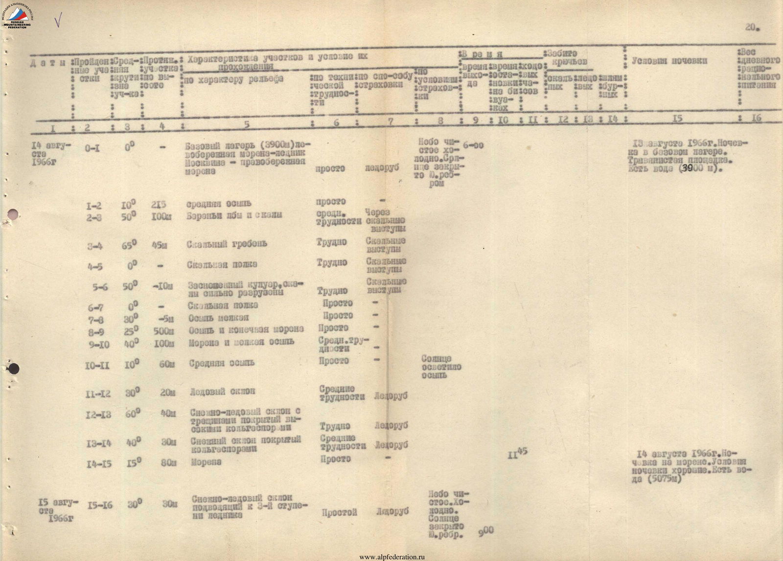
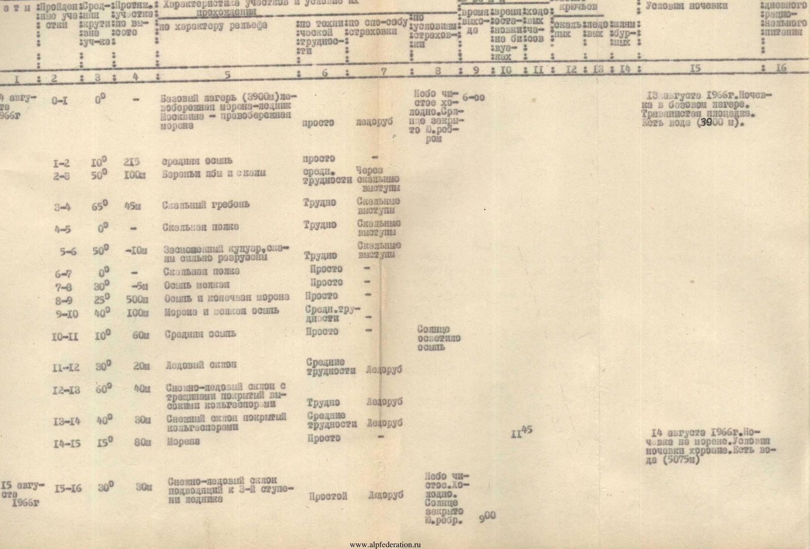
| Date | Section | Steepness | Length | Characteristics of sections and conditions of passage | Type and method of insurance | Number of hooks | Drills | Camping conditions (time of departure, stops, conditions) |
|---|---|---|---|---|---|---|---|---|
| August 14, 1966 | R0–R1 | 0° | — | Base camp (3900 m) left-bank moraine — Moskvina Glacier — right-bank moraine | straightforward | ice axe | August 13, 1966. Overnight stay at base camp. Grassy area. Water available (3900 m). Clear sky, cold. Sun hidden behind S. ridge. 6:00 | |
| R1–R2 | 10° | 215 m | Medium scree | straightforward | ||||
| R2–R3 | 50° | 100 m | "Goat tracks" and rocks | medium difficulty | rock outcrops | |||
| R3–R4 | 65° | 45 m | Rock ridge | difficult | rock outcrops | |||
| R4–R5 | 0° | — | Rock ledge | difficult | rock outcrops | |||
| R5–R6 | 50° | –10 m | Snowy couloir, rocks heavily destroyed | difficult | rock outcrops | |||
| R6–R7 | 0° | — | Rock ledge | straightforward | ||||
| R7–R8 | 30° | –5 m | Small scree | straightforward | ||||
| R8–R9 | 25° | 500 m | Scree and terminal moraine | straightforward | ||||
| R9–R10 | 40° | 100 m | Moraine and small scree | medium difficulty | ||||
| R10–R11 | 10° | 60 m | Medium scree | straightforward | Sun illuminated the scree | |||
| R11–R12 | 30° | 20 m | Ice slope | medium difficulty | ice axe | |||
| R12–R13 | 60° | 40 m | Snow-ice slope with crevasses, covered with high calga-spores | difficult | ice axe | |||
| R13–R14 | 40° | 30 m | Snowy slope covered with calga-spores | medium difficulty | ice axe | |||
| R14–R15 | 15° | 80 m | Moraine | straightforward | August 14, 1966. Overnight stay on moraine. Good conditions. Water available (5075 m). 11:45 | |||
| August 15, 1966 | R15–R16 | 30° | 30 m | Snow-ice slope leading to the 3rd step of the glacier | straightforward | ice axe | Clear sky, cold. Sun hidden behind S. ridge. 9:00 | |
| R16–R17 | 45° | 450 m | Snowy ascent; snow condition changes with time of year; currently an ice slope covered with 3–5 cm of snow | straightforward | ice axe | |||
| R17–R18 | 20° | 250 m | Firn slope | straightforward | ice axe | |||
| R18–R19 | 50° | 65 m | Snow-ice slope; in the upper part, hanging ice falls | difficult | ice axe, ice hooks, rock hook | 1 | Sun illuminated the slope |