Passport
- Altitude class
- Central Pamir
- Peak Korzhenevskaya 7105 m via the triangle of the Western wall
- Proposed — 5B cat. diff., first ascent
- Height difference: 1900 m, length — 3305 m. Length of sections with 5–6 cat. diff. — 765 m. Average steepness of the main part of the route — 73°. Of which 6 cat. diff. — 85°–120 m.
- Pitons driven: rock 172 chocks 22 ice screws 6
- Team's climbing hours: 57 and days 6
- Overnights: 1 — sitting, 1 — semi-sitting, 4 — lying
- Leader: Petrov Nikolai Evgenievich – CMS participants: Bashkirov Vladimir Leonidovich – MS, Egorov Dmitry Anatolievich – CMS, Obikhod Vladimir Nikolaevich – CMS, Stetsenko Vladimir Dmitrievich – CMS, Yanochkin Vladimir Ivanovich – CMS
- Coach: Shpolyansky Vladimir Naumovich – CMS.
- Approach to the route: July 18, 1988. Summit: July 22, 1988. Return: July 23, 1988.
- Organization: SK MGS VDFSO
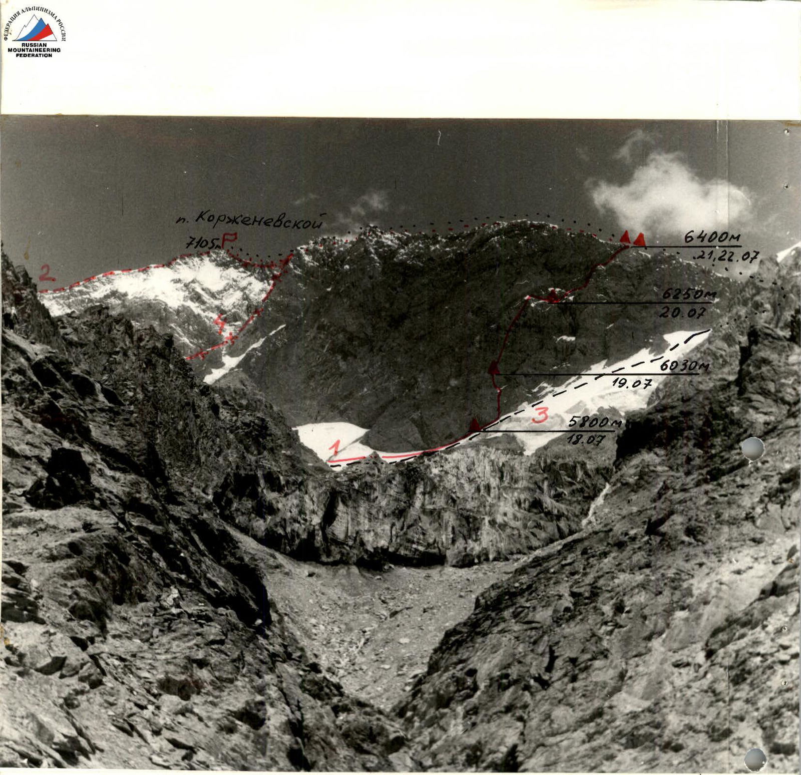
1 — the group's route,
2 — A. Ugarov's route, 1953,
3 — V. Tsetlin's route, 1966,
4 — L. Dobrovolsky's route, 1966.
Photo 1. General photo of the summit. Taken from Moskvina glacier, July 18, 1988, S=2 km, H=5100 m, Camera №1, "Lubitel", F=75 mm.
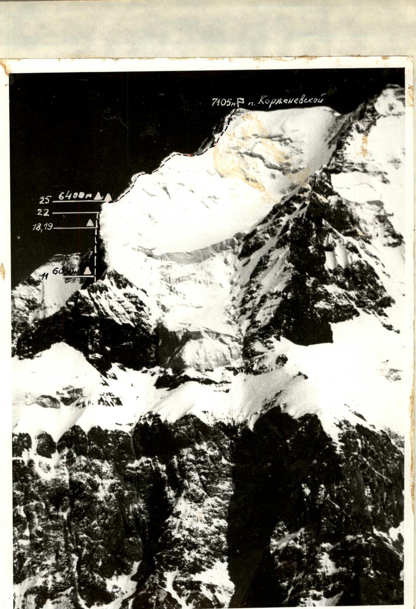
Photo 2. Profile of the wall on the right. Taken on August 18, 1988, from the slope of Peak Kommunizma, H=5600 m, S=7 km, semi-automatic "Lubitel", F=75 mm.
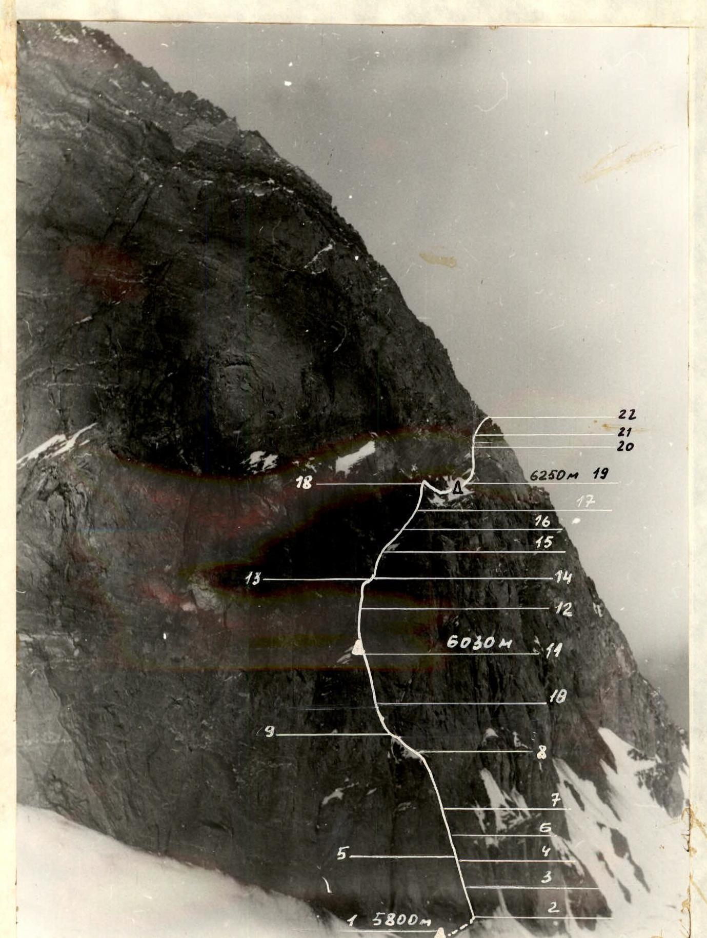
Photo 3. Profile of the wall on the left. Taken on July 18, 1988, H=5800 m, S=1.5 km, Camera №3, "Lubitel", F=75 mm.

Preparation for the Ascent
Familiarization with the object of the ascent was carried out during preparations for the season using materials from reports on ascents to Peak Korzhenevskaya, photographic materials (V.P. Masyukov provided great assistance here), and consultations with V. Kolomyttsev and V. Elagin.
In general physical preparation, considering the specifics of this ascent, we focused on:
- long cross-country runs;
- ski marathons.
Team members participated in winter training at the "Planernaya" base (skiing), ski races, and a 30-kilometer run in Crimea in May. They received special and high-altitude training on stands at MVTU and MEI, as well as during training sessions in the Caucasus, Dagestan, and Crimea, and during ascents. All participants passed physical fitness tests with excellence in May.
In early July, to gain acclimatization and team cohesion, the team made an ascent to Peak Lenin.
To finalize the route choice and tactics, the team made an exit to 5400 m under the "triangle" wall. For 2 hours, the team observed the state of the wall and determined the path to be taken.
Key data for choosing a tactical plan — rare places for possible overnight stays and rockfall danger in the lower part of the wall in the second half of the day. This determined the tactic of preliminary processing of the lower part of the wall.
To organize normal overnight stays, a hammock was taken, with which (by filling it with snow and stones) it was possible to expand the platform for the tent.
Since the wall is very steep and composed of destroyed, soft rocks, long, soft steel pitons were taken to ensure reliable protection.
Another problem with the route was the upper part of the wall, composed of different (compared to the main wall) rocks, very steep and without visible (through optical means, binoculars) places for a bivouac. One solution to this problem was to move to the right, along the ledge separating the upper part from the main wall, onto the South Ridge.
Tactical safety measures:
- Passage of the lower part of the wall in the morning;
- Overnight stays in safe places;
- Double-rope protection for the lead climber;
- Three-time daily communication via UHF radio with observation groups, groups on simpler routes, and the base.
The rescue team was located in the base camp and had good acclimatization and appropriate qualifications to perform their functions.
Ascent Schedule
Climbing hours
| July 17 | July 18 | July 19 | July 20 | July 21 | July 22 | July 23 |
|---|---|---|---|---|---|---|
| 4200–5200 m Overnight lying | 5200–5960–5800 m Overnight lying | 5800–6020–95 m Overnight sitting | 6020–6260 m Overnight semi-sitting | 6260–6400 m Overnight lying | 6400–7105 m–6400 Overnight lying | 6400–4200 m (Moskvina glacier) |
Climbing days
– descent – bad weather – processing
Team's Tactical Actions
Day 1. Leaving the base camp on the Moskvina glacier (4200 m) at 11:30, descended to "dusty overnight stays" and ascended via the moraine and glacier (in the cirque under the "triangle" wall) to 5400 m by 16:30. Here, they made the first bivouac.
Day 2. According to the tactical plan, the pair Petrov–Bashkirov left the overnight stay under the wall at 6:00 to process the route. By 7:30, they ascended the snow-ice slope to the overnight stay in the "Grotto" (sect. R0–R1). At 8:00, they began processing the wall. By 14:00, they processed 5 ropes (sect. R1–R9) and descended to the overnight stay in the "Grotto" at 5800 m. The first climber worked on a double rope (also on the entire wall) and on section R2–R8 in galoshes. The rest of the team transferred the camp from 5400 m to 5800 m (overnight stay in the "Grotto" — under an overhanging rock, well-protected from rockfall).
Day 3. Left at 7:00 AM via processed ropes. All fixed ropes were tied and secured to double pitons. The lead climber moved with lower protection. By 12:00, they passed these and thus exited the rockfall danger zone. The pair Bashkirov–Stetsenko moved forward. The section to the next planned overnight stay is very complex. They used the entire set of technical means:
- long iron pitons;
- chocks;
- friends;
- ladders;
- rock shoes. Passed 3 ropes by 17:00. Here, a narrow rock-ice ledge (place of planned overnight stay, protected from rocks by the overhanging upper part of the wall). Using a hammock (filling it with stones and ice), they created an artificial platform. The pair Obikhod–Egorov processed sections R11–R14. By 20:00, processing and preparation of the platform were completed.
Day 4. Departure at 9:00. The pair Petrov–Yanochkin moved forward. By 17:00, they passed very complex sections (R14–R18). They had to change galoshes to boots with crampons several times to overcome icy rocks. They reached a steep ledge under the upper part of the wall. Above, the wall becomes steeper and composed of rusty, very steep, and destroyed rocks (no ledges or snow). Overnight stays are only possible lying in hammocks or in a house-tent. Soft rock does not allow for reliable protection even with long pitons. They decided to move to the right, along the ledge, towards the South Ridge, as planned in the tactical plan. Egorov–Bashkirov passed 2.5 ropes along the ledge (sect. R18–R19). By 21:00, an artificial platform (using a hammock) was ready.
Day 5. Departure at 9:00. The pair Obikhod–Stetsenko led. By 15:00, they reached a small rock-ice ledge on the counterfort (sect. R19–R22). Here, the pair Bashkirov–Egorov moved forward and, traversing to the right upwards along a narrow ledge (sect. R22–R25), reached the West Ridge by 20:00. Here, there were excellent overnight stays in a hollow at 6400 m. Leaving the fixed ropes (to save time), the entire team reached the hollow by 21:00 and set up a tent.
Day 6. In the morning at 10:00, Obikhod, Egorov, and Stetsenko left to retrieve the left fixed ropes. By 12:30, the ropes were retrieved. At 13:30, the group began the summit push along the South Ridge. The weather deteriorated: snow, wind. By 17:00, in good pace, the group reached the summit and descended to the overnight stay at 6400 m by 19:00. Everyone was in excellent physical and psychological condition.
Day 7. Left at 6:30 AM to descend via Tsetlin's route, category 5A. By 14:00, they descended to the base camp.
There were no falls or injuries in the team. Communication was carried out regularly (as planned) with Nikolaev's and Odokhovsky's groups, located below Romanov's route, and with the base on the Moskvina glacier.
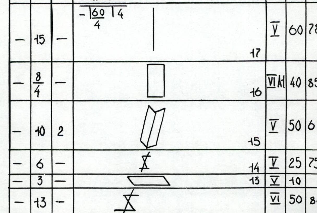
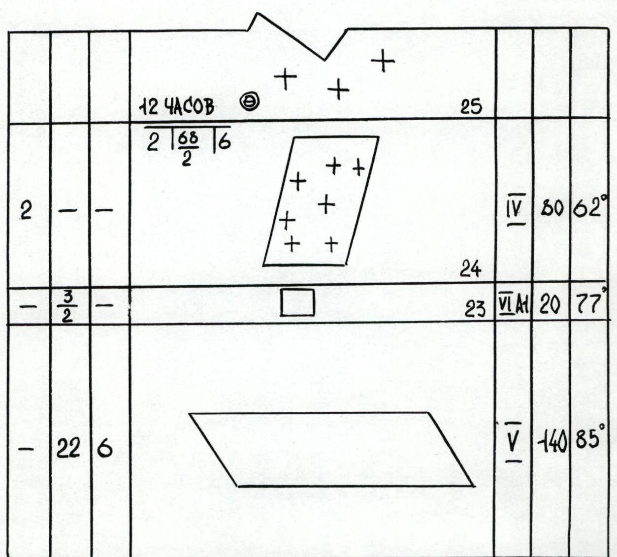
Route Diagram

| Section | Ice | Rock | Chocks | Cat. diff. | M | Steepness |
|---|---|---|---|---|---|---|
| R1 | 2 | — | — | 1 | 10 | 67° |
| R2 | — | 4 | — | 2 | 20 | 77° |
| R3 | 5 | 2 | — | 5 | 40 | 77° |
| R4 | — | 3 | — | 4 | 20 | 60° |
| R5 | — | 3 | 1 | 5 | 20 | 70° |
| R6 | — | 2 | — | 4 | 10 | 55° |
| R7 | — | 6 | 3 | 4 | 40 | 75° |
| R8 | 2 | 4 | — | 4 | 40 | 52° |
| R9 | — | 8 | — | 4 | 40 | 70° |
| R10 | — | — | — | 4 | 60 | 80° |
| R11 | — | — | — | 5 | 50 | 80° |
| R12 | — | 13 | — | 6 | 50 | 80° |
| R13 | — | 3 | — | 5 | 10 | — |
| R14 | — | 6 | — | 5 | 25 | 75° |
| R15 | — | 10 | 2 | 5 | 50 049 | 67° |
| R16 | 8 | 4 | — | 6А1 | 40 | 85° |
| R17 | — | 15 | — | 5 | 60 | 78° |
| R18 | — | 17 | — | 4 | 180 | 60° |
| R19 | — | 5 | — | 4 | 40 | 52° |
| R20 | — | 13 | — | 5 | 50 | 80° |
| R21 | — | 8 | — | 5 | 30 | 80° |
| R22 | — | — | — | 5 | 30 | 80° |
| R23 | — | 3 | 2 | 6 | 20 | 77° |
| R24 | — | — | — | 4 | 80 | 62° |
| R25 | 2 | — | — | 4 | 80 | 62° |
| R26 | — | 22 | 6 | 5 | 140 | 85° |
Climbing hours: 57

Route Description by Sections
R0–R1. From the moraine of the glacier (height 5400 m) in the cirque of the right part of the Western wall of Peak Korzhenevskaya, ascend a 30°–40° glacier slope under the "triangle" wall to the overnight stay "Grotto" at a height of 5800 m. Movement is simultaneous in rope teams. The glacier is "closed".
R1–R2. From the overnight stay, ascend 10 m upwards to the right along the ice to a 20 m wall under an internal angle. Protection is piton. Starting from this point, the first climber goes on a double rope. The rest follow the fixed ropes.
R2–R3. The wall of large, destroyed rocks is ascended directly upwards. This section should only be climbed in the morning due to rockfall danger.
R3–R4. Further, 40 m upwards along the internal angle. Climbing is complex, with many loose rocks. Exit onto an inclined ledge. Protection is mainly using long, soft pitons.
R4–R5. Traverse 20 m to the left along the ledge. Protection via pitons.
R5–R6. A 20 m wall is overcome "head-on" to the next ledge.
R6–R7. Traverse 10 m to the left along the ledge, crossing an ice-filled internal angle.
R7–R8. Directly upwards along the right side of the internal angle for 40 m. Exit onto a steep snow-ice ridge. Protection is piton.
R8–R9. To the right along the snow-ice ridge to a wall with an overhang. Protection via pitons and ice screws.
R9–R10. Traverse directly upwards along very steep rocks, bypassing the overhang. Climbing is complex, with many loose rocks.
R10–R11. Further directly upwards 50 m along very difficult rocks. Climbing is extremely complex. The first climber works in rock shoes (or galoshes). The rock is heavily destroyed, requiring extreme attention and careful protection. Long steel pitons are used. At the end of the section, there is a small inclined ledge. Using a hammock, a sitting bivouac was made. The bivouac is protected from rocks by an overhanging wall.
R11–R12. From the overnight stay, ascend to the right upwards to intersect with a crack going in the same direction.
R12–R13. Further 50 m along the crack to a ledge; in the upper part, the crack is filled with ice. Climbing is extremely complex. Protection via pitons and chocks.
R13–R14. Along the ledge, 10 m traverse to the right. From here, the crack continues.
R14–R15. Further 25 m along the crack to a niche, at the top of which is a rock plug.
R15–R16. From the niche, exit into an internal angle, which is ascended along the right part. The internal angle ends in a wall. Protection via pitons.
R16–R17. 60 m directly upwards along the edge and exit onto a steep ledge crossing the wall. Protection via pitons.
R17–R18. 160 m traverse to the right along the ledge. The ledge is heavily destroyed by gullies and vertical walls.
In the middle of the ledge, an overnight stay is possible.
Using a hammock, prepare a platform for a normal tent setup.
R18–R19. The ledge abuts a counterfort. 40 m upwards to the right to where the counterfort meets the wall.
Protection via pitons and ice screws.
R19–R20. 50 m upwards along the counterfort wall to an internal angle. Climbing is complex, very unpleasant due to heavily destroyed rocks. Long steel pitons are used.
R20–R21. Along the internal angle, exit onto the counterfort ridge. In the upper part, there are icy rocks (there is a small ledge here). Protection via pitons.
R21–R22. From the counterfort, along a very narrow and steep ledge going to the right upwards (towards the South Ridge), traverse 140 m. The ledge is not clearly defined, interrupted by steep walls. Protection via pitons and chocks.
R22–R23. The ledge ends. Here, directly upwards along a very steep wall with an overhang, leading to the South Ridge. Climbing is extremely complex. Protection is piton.
R23–R24. Traverse along the ice towards the hollow on the South Ridge. Here, there are excellent overnight stays.
R24–R25. Along the South Ridge, exit to the summit. Descent via Tsetlin's route, category 5A.