Ascent Passport
I. Ascent class - high-altitude 2. Ascent area - Central Pamir, Akademiya Nauk Range 3. Peak, its height, ascent route - Peak E. Korzhenevskoi, 7105 m, east face 4. Proposed difficulty category - highest 5. Route characteristics:
elevation gain - 2600 m, average slope - 55°, length of sections with 5th difficulty category - 525 m.
- Pitons driven: for belaying, for creating intermediate anchors (I.T.O.)
rock 21, 8 ice 30, 2 bolted 7, 4
- Number of travel hours - 56.5 hours
- Number of nights and their characteristics - total 8
3 - semi-sitting on ice in a torn tent; 5 - on snow.
- Surname, Name, Patronymic of the team leader, participants, and their qualifications: Team leader - Sviridenko Vadim Sergeevich - Master of Sports (MS). Participants: Kondakov Evgeny Ivanovich - MS. Vlasenko Alexander Ivanovich - Candidate for Master of Sports (CMS). Nelupov Vitaly Andreevich - CMS.
- Team coach - Sviridenko Vadim Sergeevich. II. Dates of departure and return:
July 29 - August 8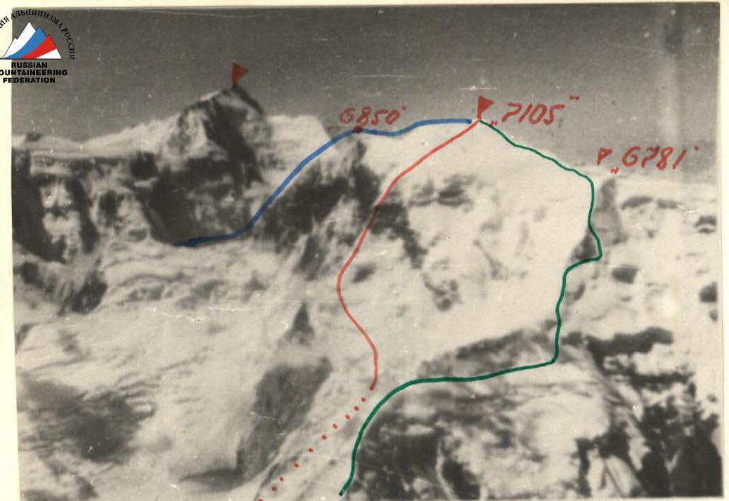
Conditioned by E. Norminebenova (by city)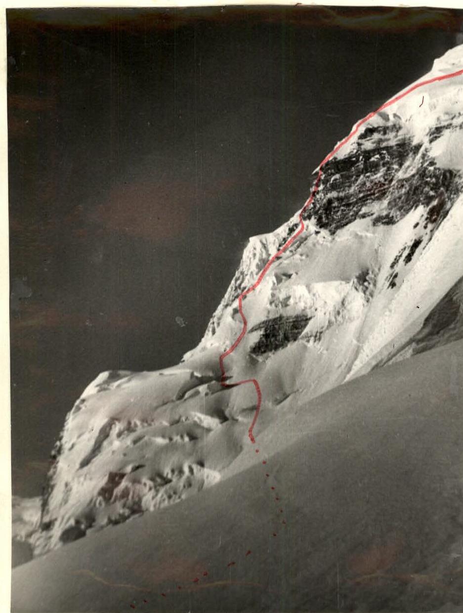
Profile photograph of the east face. Conducting high-altitude expeditions has become a tradition for the Odessa regional council of the "Avangard" Sports Society. In just the last 10 years, 6 expeditions have been conducted to various regions of the Pamir and Tien Shan. Ascents have been made to all Pamir seven-thousanders via classified routes, and experience has been gained in first ascents.
In 1974, participating in the country's championship in the high-altitude class, the team of the regional council attempted a first ascent on Peak Khan-Tengri via the south face from the South Inylchek glacier. Over 9 days, the group overcame 1300 m of the most technically challenging part of the route but was forced to descend via the ascent route due to a sharp change in weather conditions and increased avalanche danger.
The second group of the expedition became the first Ukrainian team to repeat the path of the pioneers of 1931, led by M.T. Pogrebetsky.
Having received permission to participate in the 1976 USSR Championship, the team entered the high-altitude ascent class with a first ascent on Peak E. Korzhenevskoi via the east face. This required organizing an expedition to the Mushketov glacier. The idea of the expedition captivated everyone, especially since we cherished memories of one of the first Odessa expeditions in this region of the Pamir, when during the 1969 USSR Championship, we traversed Sandal-Muzhzhilga.
Ascents to the highest peaks, despite being troublesome and labor-intensive in preparation and execution, bring us deep satisfaction not only because they require constant technical and tactical improvement as athletes. They provide valuable life experience, essential in our daily lives and activities.
The 1976 season is a jubilee year for Odessa climbers. Alpinism in Odessa is 40 years old. We dedicate our ascent on Peak E. Korzhenevskoi to this significant date.
Brief geographical description of the area
Peak E. Korzhenevskoi (7105 m) is the fourth seven-thousander in the USSR, located in the Central Pamir in the northwestern extremity of the Akademiya Nauk Range, 13 km north of Peak Kommunizma (7495 m), situated at the junction of the meridional Akademiya Nauk Range and the latitudinal Peter the First Range.
The peak's massif, bounded by Peak Babushkina (6200 m) to the east and peak 6281 m to the west, closes the narrow, deep, and steep valley of the Mushketov glacier, which approaches the valley of the Muksu River from the south.
The powerful modern glaciation of the northern slopes of the peak, a huge snow-firn basin formed by:
- the northeastern ridge,
- the eastern ridge,
- a spur from peak Babushkina into the Muksu valley,
serves as the feeding zone for the glacier.
The glacier valley deeply cuts into the peak's massif, forming steep, often sheer slopes with an elevation gain of up to 3000 m.
Orography and geology of the northern slopes of the peak. Justification of the chosen route
The orography of the northern side of the peak is quite simple and does not present difficulties.
The peak's summit, bounded by marks 6895 m to the east and 6781 m to the west, is a huge ice-snow dome of variable steepness that transitions:
- to the east - into a sheer wall,
- to the northeast - into a slope with steep ice fields, icefalls, and rock walls.
Both slopes - eastern and northeastern - are affected by the mobile ice masses of the summit dome.
The intersection of the surfaces of these slopes forms a giant, steep counterfort that runs from the firn plateau of the Mushketov glacier at an altitude of 4800 m and ends on the summit dome in the immediate vicinity of the summit.
The lower part of the counterfort from 4800 to 5500 m is a rock belt made of crumbling schist, has a characteristic triangular shape, and ends in an ice dome.
The subsequent ice-snow counterfort, in our opinion, most fully corresponds to the distinctive features of high-altitude routes.
At an altitude of around 6000 m, the ice character of the counterfort is interrupted by a rock precipice extending up to 400 m.
By declaring the east face of the peak for participation in the USSR Championship, we had in mind this route, which we considered unambiguous and safe, although it may need clarification regarding its spatial orientation.
In this report, for convenience, we retain the terminology used in the application.
Regarding the geological structure, the peak's massif is not a single entity. Here, we observe:
- in the lower outcrops - metamorphic schist,
- in the upper - complex limestone-schist rocks,
- inclusions of intrusive rocks.
These features of the geological structure are directly related to the intensity of denudation processes and significantly influence the nature and tactics of mountaineering routes from the north.
Information on the history of exploration and mountaineering development of the Peak E. Korzhenevskoi area from the Mushketov glacier
The history of geographical research and mountaineering development of the Pamir, its highest peaks, and, in particular, Peak E. Korzhenevskoi, is sufficiently covered in geographical and mountaineering literature. In recent years, the peak has become one of the most popular in the Pamir.
However, it is worth noting that the northern side of the peak is significantly less explored than the southern side in terms of the number of expeditions and climbers.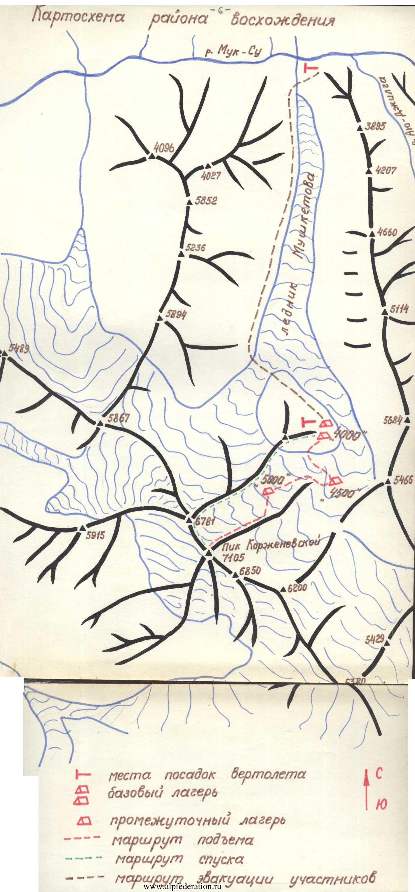
Key milestones in the history of the northern side of the peak:
- 1904 - first mentions by N.L. Korzhenevsky about the Kara-Sel glacier, later renamed the Mushketov glacier.
- 1910 - N.L. Korzhenevsky's discovery of the "giant ice massif rising in the background of the Kara-Sel valley".
- Since 1927 - official name: Peak E. Korzhenevskoi.
- 1932 - examination of the Mushketov glacier up to its headwaters by participants of the Tajik Academy of Sciences expedition.
- 1965 - expedition by Leningrad climbers. Attempt to ascend the peak via the northeastern ridge.
- 1968 - a) First ascent to the peak from the Mushketov glacier via the northeastern ridge by a group of Donetsk climbers (led by Sivtsov) - 10 people. b) Repetition of the route by an expedition of Uzbek climbers (led by Zilchibekov) - 19 people.
- 1969 - Ascent to Peak E. Korzhenevskoi from the Mushketov glacier by sports groups of the Dnepropetrovsk and Leningrad climbers' expedition via peak Babushkina along the eastern ridge (first traversed in 1966 from the Moskvin glacier by a group led by Kuzmin-Bожуков) - 18 people.
- 1974 - Attempt by Uzbek climbers to traverse the east face of the peak. Abandonment of the ascent due to increased rockfall hazard in the lower part.
Summing up the mountaineering development of the northern side of the peak at the time of the expedition's organization, we concluded that the possible ridge routes to the summit had been traversed. The east face became the subject of study and an unsuccessful attempt to traverse.
Due to the natural and necessary process of further mountaineering development of the area, considering the structure, length, and obvious technical and tactical complexity, the east face of Peak E. Korzhenevskoi appears to be one of the few remaining major problems for first ascents on the Pamir seven-thousanders. The developed tactical plan for the ascent was based on the following results and conclusions from reconnaissance, supply drops, and acclimatization:
-
Ascending the rock wall from the Mushketov glacier to the "triangle" (altitude 5500 m) is extremely hazardous due to constant rockfall and the impossibility of organizing reliable belays due to the crumbling nature of the rocks. Despite being technically accessible for the group, this ascent option was ruled out due to safety concerns.
-
The ascent to the "triangle" should be carried out via the supply drop route, strictly adhering to the movement schedule on avalanche-prone areas only in the morning hours:
1st day - "4500" - "5000" 2nd day - "5000" - "5500"
- The visible path from the "triangle" up the wall represents a combined route of the highest difficulty with problematic sections on rocks and ice. This places particularly serious demands on the selection of special equipment.
- Due to the unreliability of the "Vitalka" radio set, only "Nedra" and "Karat" radio sets will be used.
- Since team members A. Popov and A. Stavnitser were not cleared by the doctor to ascend to high altitude due to health reasons, the composition of the sports team became the minimum allowed - 4 people (due to the limited number of participants allowed in the championship). This required special attention to interaction within the group and careful backup planning in case of an emergency situation. Based on these considerations and our own high-altitude experience, the following ascent plan was adopted:
Day 1 - Base camp - plateau 4500 m. Day 2 - Plateau 4500 m - icefall 5000 m. Day 3 - Icefall 5000 m - "triangle". Day 4 - "Triangle" - foot of the rock wall. Day 5 - Work on the wall. Day 6 - Completion of wall passage and exit to the summit dome. Day 7 - Summit. Days 8-9 - Descent to the base camp via the northeastern ridge.
Day 10 - Reserve day for bad weather.
The adopted tactical plan is merely a guideline. In each specific situation, it is necessary to:
- realistically assess the situation,
- evaluate one's strengths,
- make a clear decision,
- and execute it.
Taking into account the planned reserve day, the ascent took one day longer than we had calculated. This was due to:
- the challenging state of the route after precipitation on July 30-31,
- bad weather on August 4, when we were unable to fulfill the planned daily plan.
Otherwise, the plan was executed, despite encountering unusual snow and ice conditions, as well as a combination of rock formations.
Ascent chronicle
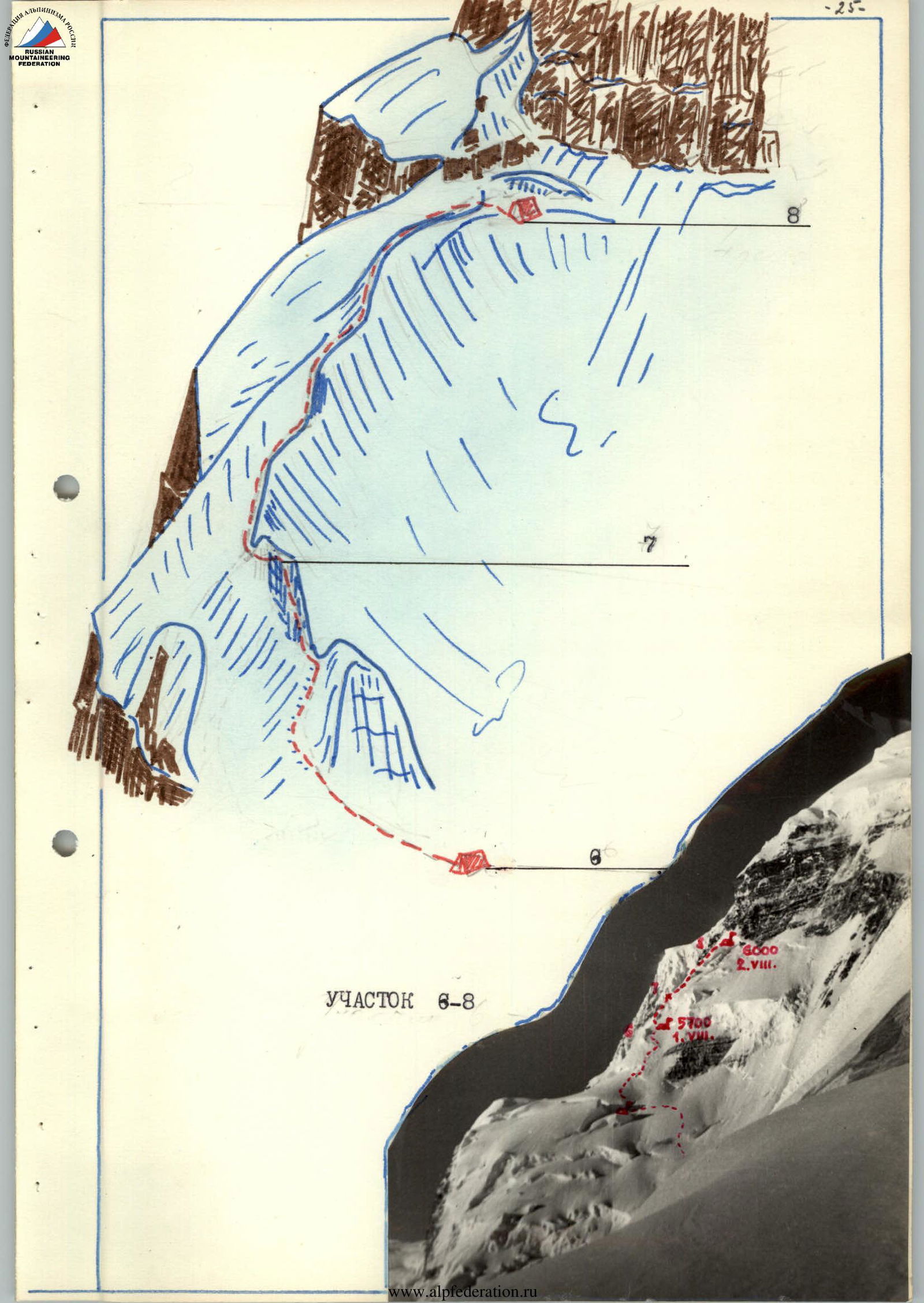
July 29. We departed from the base camp at 16:00. The journey to the "4500" camp on the upper plateau of the Mushketov glacier took 2 hours and 30 minutes on a familiar path. Due to the large number of crevasses, we traveled in teams. At "4500", we had tents with supplies of all kinds and equipment. We rested from the bustle and dust of the base camp. Early bedtime. The task for tomorrow:
- quickly move to the intermediate camp "5000"
- settle in the icefall between the northeastern ridge and the northeastern slope.
Day 1 - July 30
R1 - Departure from the "4500" camp at 6:00. We circumvented and overcame crevasses in the direction of the middle part of the icefall, then moved along the melted-out snow drifts and steep climbs of the II degree icefall at the maximum possible speed. After four hours of continuous movement, we reached our "Pamirka" tent standing under a giant protective awning-canopy. 10:30. Unfortunately, it started snowing, lightly and monotonously.
Yevgeny and Vitaly processed the path for the next day for 2 hours, while we tried to greet them with a delicious lunch. We went to bed early, as tomorrow was also a sprint day.
Day 2 - July 31
R2. Early rise. Fog, but visibility was sufficient. The snow was still falling, or so it seemed to us. From the tent:
- 30 m to the bergschrund bridge
- an intricate bridge
- 40 m slope (45°) on dense firn
- 30 m descent on deep snow into the mouth of a wide ice couloir - steepness 60°
The couloir was polished, and we considered it to be in a "working condition".
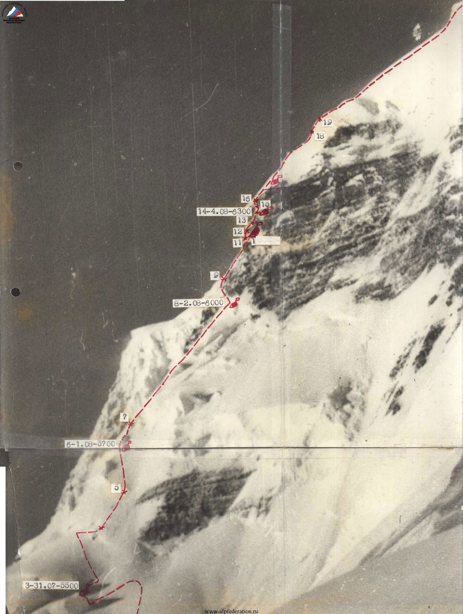
20–6.08
17–2.08
18
14–4.08
10–3.08
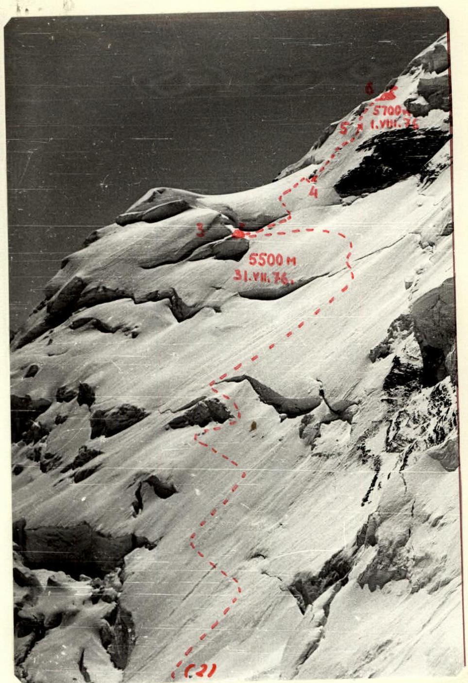
8–2.08–6000
6–1.08–5700
3–31.07–5500
www.alpfederation.ru
–20–
1–30.07–3000. Overcoming the couloir was the first technical task. We cut steps, used 6 ice pitons, and covered a distance of 80 m. Then, we exited onto snow (35 m) onto a ridge and along it onto an ice wall with huge (40 m) icicles. We descended 30 m along the ice slope and exited onto a snow shoulder on the northeastern slope.
R3. Further, we moved left and upward along snow fields, transitioning into snow-firn slopes with steepness up to 50° in some areas. When overcoming crevasses and steep sections, we used alternating movement. Belaying was done through an ice axe. The closer we got to the "triangle", the deeper the snow became. We moved in a trench. Finally, we reached the supply cache, which was left in a high-altitude tent on the top of a serac.
Day 3 - August 1
R4. Departure at 9:00. From the tent, it seemed close to the bergschrund, but the snow was very deep. We began to dig into the snow:
- 40 m of trench to the crevasse
- searching for a reliable bridge (40 m along the crevasse)
- 120 m along the slope with increasing steepness
We exited onto an ice wall. In front of the wall, there was a large crevasse and a difficult exit onto the wall.
R5. The wall was 70 m long. We cut steps and used 5 ice pitons. It was difficult to move ahead, but it seemed even harder to dodge falling ice with continuous, stinging snow drift.
R2–R6
R6. The wall transitioned into a snow-ice slope with a steepness of up to 45° - 150 m along the slope, and the first team exited onto a snow ridge. This was not the main ridge of the counterfort but one of many ridges leading to it. 17:00. We could still move, but we decided to bivouac at the foot of a large ice gendarme. We prepared a decent bivouac site by 19:00. The gendarme did not justify our hopes and offered little protection from the wind and snow.
Day 4 - August 2, 1953
R7
A strong, cold wind blew in the morning. The ridge was swept by a sharp snow drift. We departed the bivouac at 9:00. The second team struggled with the frozen tent for another hour.
Vadim and Yevgeny began to circumvent the gendarme on the left. The steep ice slope was covered with a thin layer of firn. For each piton, a shovel was needed. We traversed the gendarme and passed an ice wall.
R8
Ahead lay a long, steep ridge leading to a rock wall. We moved slowly. We traversed certain 250-meter sections of the ridge with "belays through an ice axe" - a purely symbolic belay, as the snow was very loose and deep.
We stopped for a bivouac 30 m from the rock wall. The site in the snow turned into a deep snow pit, where the tent was hidden. A strong, gusty wind from the wall blew snow onto us. It was clear but very cold.
We planned the next day's route:
- We could exit onto the rocks,
- But an alternative route was visible, bypassing the first rock belt.
To do this, we needed to:
- exit onto a snow ridge to the left of our current ridge,
- separated from us by a wide ice couloir and a wall with individual rock outcrops.
Day 5 - August 3
R9
We departed the bivouac at 9:00. The weather was excellent, clear, and cold. The snow blowing in our faces slightly hindered our progress. 10 m from the rocks, we traversed a steep ice slope with a crevasse, then moved into a couloir - cutting steps, using screw pitons. We exited the couloir via a sheer rock wall, followed by a steep ice slope with rock outcrops.
R10. Further, we moved along a ridge leading to a rock tower. The steepness was 60°, and the length was 120 m. Our hopes for a platform at the junction of ice and rocks were not justified, although from below it seemed like there was something. By 19:00, we managed to find something resembling a sitting bivouac. Under a sharp gust of wind, one of the tent's poles broke. At night, it started snowing, and we struggled with snow flows that slid from the wall onto the tent.
Day 6 - August 4. R11. We departed the bivouac at 9:30. The weather was poor - fog, snow, wind. From the bivouac site, we descended into a frozen couloir along a slope with a steepness of up to 80° onto a narrow shelf covered in ice.
R12. 30 m of difficult climbing led us to a нависающий камень (overhanging rock) that blocked the entrance to an internal angle. We climbed without backpacks and used ladders.
R13. The internal angle presented a combination of steep, frozen slabs. Movement was very slow. There were sections with нависающие скалы (overhanging rocks). We used a full range of pitons. The transition from ladders to a snow-covered ledge leading upward to the apparent exit onto ice was very difficult. Pulling up backpacks was exhausting.

R8–R10, especially under conditions of:
- continuous snowfall
- entire streams of snow flowing down the rocks.
R14. The only further path was along a snow-covered ledge along a sheer wall, beyond which the summit dome began.
40 m of ascent using all types of pitons led us onto a short ice shoulder, crowned with a "sympathetic" snow-ice ledge. We spent 2 hours preparing a platform. The bivouac was semi-reclining. The weather did not improve - fog, snow. We barely slept at night, constantly clearing snow from the tent roof.
Day 7 - August 5. R15. We departed the bivouac at 9:00. We ascended the ice cap, cutting steps - from left to right, upward 20 m. Belaying was done with pitons (1 ice, 1 ice into rocks, 2 rock).
R16. Further, we climbed a vertical 20-meter wall, partially нависающая (overhanging), using ladders on a double rope. 10 pitons were driven (including 4 bolted), and we exited onto the snow ridge leading to the summit dome. We pulled up our backpacks.
R17. Along a snow slope (40 m), we reached a snow-ice ridge with a steepness of up to 40°, extending 50 m to an individual stone. Under the stone, we carved out a platform in the ice ridge. The bivouac was semi-reclining. The weather was poor.
Day 8 - August 6.
R18. We departed at 8:45. Along a sharp snow-firn ridge with a steepness of 45°, extending up to 200 m, with individual firn-ice walls up to 3-5 m, we approached an ice wall.
R11–R14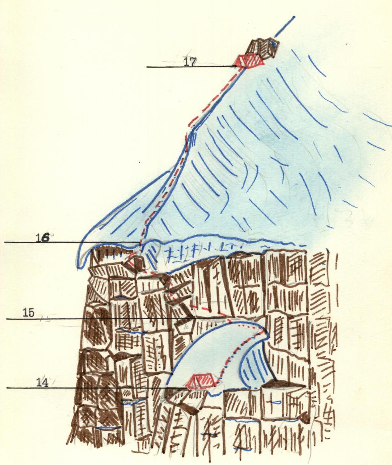
R14–R17
R17–R20. R19. The ice wall had a steepness of up to 70°. The length was 25 m. At the bottom, belaying was done through an ice axe hammered in with a mallet; further - ice pitons, using ladders, cutting steps. We pulled up our backpacks. R20. After a short rest, we continued along a snow-firn ridge and slopes with a steepness of 30-35°. The snow was very deep and loose in places. We moved alternately or simultaneously. We stopped for a bivouac at 17:00 on a gentle snow slope. The weather was clear and sunny. We decided to rest a bit and dry the tent. Judging by everything, the summit should be tomorrow.
Day 9 - August 7
R21. We departed the bivouac at 9:00. Along gentle snow-firn slopes with a steepness of 30°, overcoming individual crevasses, we slowly ascended in deep snow towards the summit. This day will be remembered by everyone for a long time. Bright sun, slight frost, the crunch of crampons on hard snow. Frequent falls into deep snow pits were irritating but not more. The summit was already close. At 11:00, we reached the summit. We found a note left by a group of Polish climbers. We admired the majestic panorama of Peak Kommunizma. At 11:30, we began our descent along the northeastern ridge. On the descent, we had a joyful meeting with V. Mamchich's group. We rested, waiting for them to return from the summit. We continued our descent together to the 5700 m camp.
Day 10 - August 8. We departed the bivouac at 9:00. We descended to the base camp on the Mushketov glacier by 15:00. A joyful meeting with comrades. The ascent was completed.
Table of main characteristics of the ascent route
Ascent route - Peak E. Korzhenevskoi via the east face (first ascent)
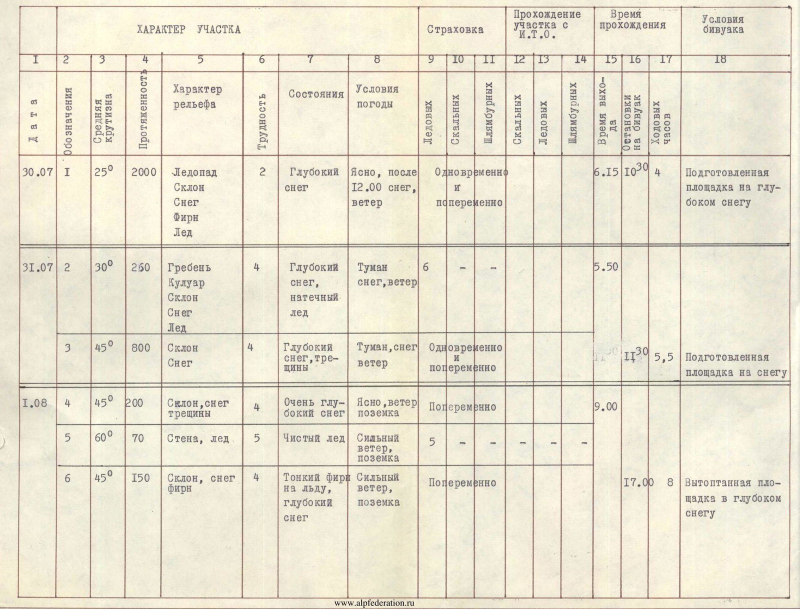
| Date | Section № | Length (m) | Elevation gain (m) | Relief, coverage | Category | Relief and coverage features | Weather | Movement method | Passage time (h) | Rocks | Ice | Rock | Snow | Start time | End time | Bivouac time (h) | Bivouac | Notes |
|---|---|---|---|---|---|---|---|---|---|---|---|---|---|---|---|---|---|---|
| 2.08 | R7 | 60 | 100 | Wall, Snow, Firn | 5 | Thin firn on ice | Clear, wind, snow drift | 7 | - | - | - | - | 9:00 | - | - | - | Ice platform carved on the ridge | |
| 2.08 | R8 | 45 | 240 | Edge, Snow | 4 | Deep snow | Clear, wind, cold | Alternating | - | - | - | - | 16:30 | 7.5 | - | - | ||
| 3.08 | R9 | 60 | 80 | Ice couloir, Rock wall, Slope, Firn | 5 | Frequent ice, monolithic rocks, Firn | Clear, wind | 2 | 6 | 1 | - | 9:00 | - | - | - | Carved platform on a narrow ice ridge, semi-sitting, tent torn by wind | ||
| 3.08 | R10 | 60 | 120 | Ridge, Snow, Firn | 5 | Loose snow | Clear, wind | - | 3 | - | - | - | 18:30 | 9.5 | - | - | ||
| 4.08 | R11 | 60 | 20 | Wall, Firn | 3 | Loose firn | Fog, snow, wind | Descent | - | - | - | - | 9:00 | - | - | - | Carved platform on an ice shoulder, semi-sitting, tent torn by wind | |
| 4.08 | R12 | 80 | 30 | Rock couloir, Ice | 5 | Frozen monolithic rocks | Fog, snow, wind | - | 3 | - | 2 | - | - | - | - | - | ||
| 4.08 | R13 | 70 | 40 | Rock slabs | 5 | Snow-covered, frozen. | Fog, snow, wind | 1 | 3 | 2 | 2 | - | - | - | - | - | ||
| 4.08 | R14 | 60 | 40 | Rock ledge | 5 | Snow-covered, frozen. | Fog, snow, wind | 2 | 2 | 2 | - | - | - | 18:00 | 9 | - | ||
| 5.08 | R15 | 50 | 30 | Snow-ice cushion | 4 | Thin snow on ice | Clear, wind, snow drift | 2 | 2 | - | - | - | 9:00 | - | - | - | Narrow ice platform carved in ice under the protection of an embedded stone from the wind, semi-sitting | |
| 5.08 | R16 | 90 | 20 | Rock wall | 5 | Complex structure | Clear, very cold | - | 2 | 2 | 4 | - | 4 | - | - | - | ||
| 5.08 | R17 | 40 | 50 | Ridge, Snow | 3 | Deep snow | Clear, cold | Alternating | - | - | - | - | 15:00 | 6 | - | - | ||
| 6.08 | R18 | 45 | 200 | Ridge, Snow, Firn | 4 | Deep snow, firn | Clear, sun | Alternating | - | - | - | - | 8:45 | - | - | - | Trampled platform in very deep snow | |
| 6.08 | R19 | 70 | 25 | Wall, Ice | 5 | Clear ice | Clear | 5 | - | - | - | 2 | - | - | - | - | ||
| 6.08 | R20 | 35 | 350 | Slope, Snow | 3 | Very deep snow | Clear | - | - | - | - | - | 17:00 | 7 | - | - | ||
| 7.08 | R21 | 30 | 600 | Slope, Snow | - | Snow, Firn, Crevasses | Clear, wind | - | - | - | - | - | 8:30 | - | - | - |
Team captain and coach (V. Sviridenko)
Footnotes
-
- helicopter landing sites