USSR ALPINISM FEDERATION CS SDSO "Burevestnik"
Report
on the first ascent of the southern ridge of Peak E. Korzhenevskaya (7105 m) by the CS SDSO "Burevestnik" team
Team Captain /V. Tsetlin/ Coach /V. Smit/
Moscow, 1966
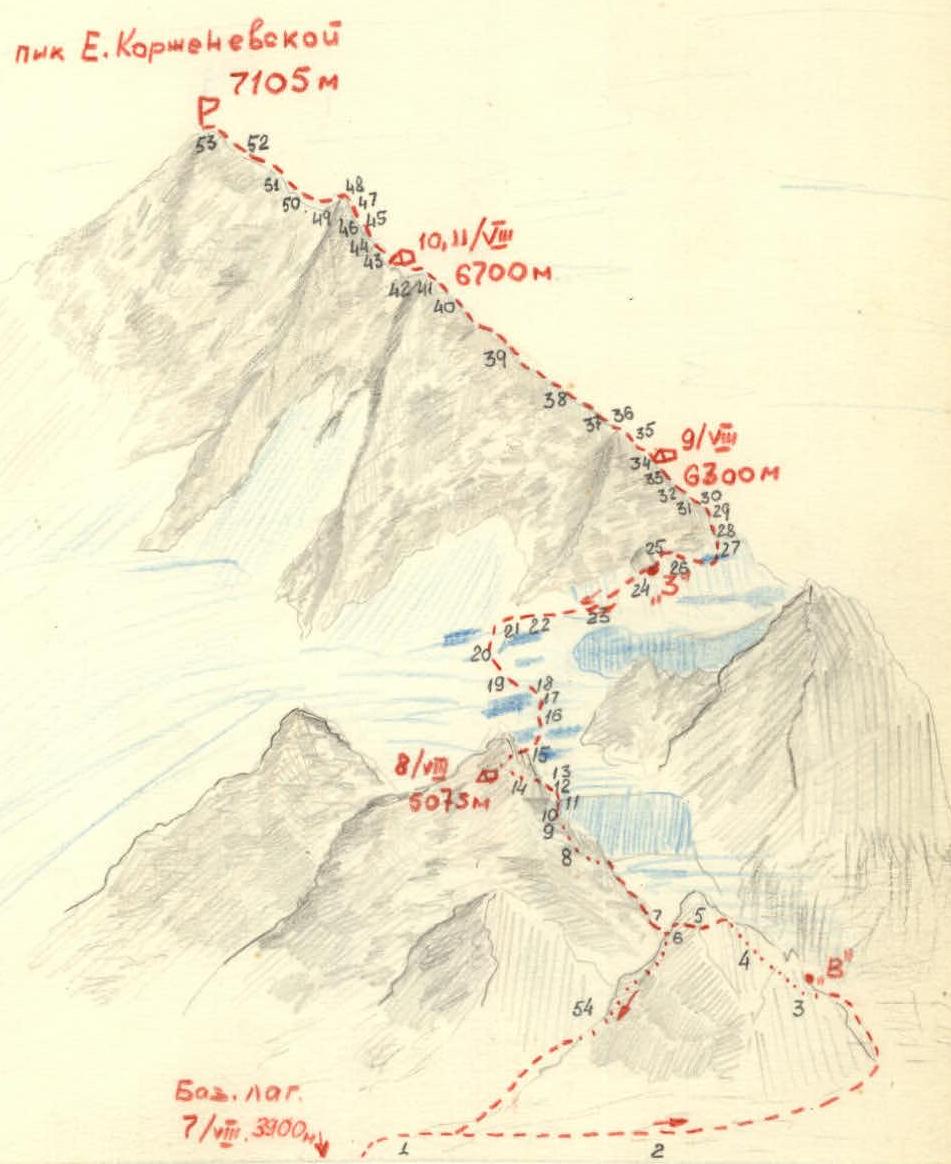
Fig. 2. Scheme of ascent to Peak E. Korzhenevskaya. The scheme indicates the sections shown on the profile map.
- Brief geographical description and sporting characteristics of the ascent object
Peak E. Korzhenevskaya (7105 m) is located in the northwestern spur of the Academy of Sciences range, in close proximity to the highest peak in the Soviet Union - Peak Kommunizma. The main orographic issues of the Peak E. Korzhenevskaya mountain node were resolved in 1932 by an expedition of the USSR Academy of Sciences. The powerful glaciation of Peak E. Korzhenevskaya belongs to the basins of the:
- Fortambek
- Mushketov glaciers
The valleys of these glaciers and their lateral tributaries deeply cut into the peak's massif, forming steep, often sheer walls; altitude differences reach 3000–3500 m.
The first attempts to ascend Peak E. Korzhenevskaya date back to 1936 with an approach from the Korzhenevsky gorge side. A repeated, and also unsuccessful, attempt was made in 1937. However, it was not until 1953 that eight participants in the Pamiro Expedition of the All-Union Central Council of Trade Unions climbed to the summit via the western ridge. This ascent was rightly considered one of the greatest achievements of Soviet mountaineering. In 1961, participants in the expedition of the "Trud" Sports Society attempted to conquer Peak E. Korzhenevskaya. A successful ascent was made along the southeastern ridge of the E. Korzhenevskaya massif, with an exit to the peak through the eastern sub-summit.
However, until recently, the most direct routes to the summit of Peak E. Korzhenevskaya had not been traversed:
- along the southwestern wall
- along the southern ridge
Both these routes, leading directly to the summit of Peak E. Korzhenevskaya, were designated as the main sporting events of the CS SDSO "Burevestnik" 1966 expedition.
Regarding the ascent along the southern ridge, despite the route's logical and natural progression, the best path to the ridge itself remained unclear, as below 5800 m the ridge breaks into a series of spurs ending in walls. Finding a safe path to the ridge was crucial for creating the necessary prerequisites for a successful ascent to the summit of Peak E. Korzhenevskaya.
- Team preparation. Reconnaissance exits. Tactical ascent plan. Composition of the assault team
Preparation of the participants for the planned ascent of Peak E. Korzhenevskaya began long before departure to the mountains. Throughout the autumn and winter of 1965–1966, training was conducted three times a week at the Moscow State University sports complex, as well as in Tsaritsyno.
Training included:
- cross-country running to develop endurance,
- skiing,
- a set of exercises with weights to develop arms and torso,
- sports games - football, basketball.
The overall training plan and standards were approved by the CS SDSO "Burevestnik". Two weeks before departing to the mountains, a check of the physical preparation of the participants for the planned ascent was conducted. All participants showed good results, exceeding the level of preparation in previous years.
The group members were well-acquainted with each other through years of joint ascents on the peaks of the Caucasus, Pamir, and Tian Shan. Particularly valuable was the experience of joint ascents on such peaks as Peak Kommunizma (1961) and Khan-Tengri from the north (1964). Before departing to the mountains, all available materials on the Peak E. Korzhenevskaya area were thoroughly studied.
The CS SDSO "Burevestnik" expedition arrived in the village of Lakhsh on July 14. On July 26, all participants gathered at the base camp, located on a clearing behind the left-bank moraine of the Moskvina glacier, directly opposite the southwestern wall of Peak E. Korzhenevskaya.
The height of the base camp was 3900 m.
On July 29, a group consisting of V.M. Tsetlin (leader), V.A. Smit (coach), O.V. Bragin, L.D. Kalachev, V.I. Egorov, O.F. Kulikov, I.F. Shchegolev, and S.V. Tikhvinsky - set out on a reconnaissance to the upper reaches of the Moskvina glacier. It was planned to combine reconnaissance of the route to the southern ridge with an acclimatization ascent.
The decision to combine the reconnaissance exit with an acclimatization ascent was due to a significant delay (by 10 days) in the start of the expedition's sporting work due to the absence of helicopters in Lakhsh. Peak Chetirekh (6299 m) via the western ridge, category 4A, was chosen as the object for the acclimatization ascent. O. Kulikov was to lead the ascent on Peak Chetirekh. The reconnaissance revealed that from the southeastern side of the southern ridge of Peak E. Korzhenevskaya, there were no logical and safe paths to the ridge. In this regard, it was decided, after completing the acclimatization ascent, to examine the possibilities of reaching the southern ridge from the southwestern wall of Peak E. Korzhenevskaya.
The ascent on Peak Chetirekh was completed in one day - July 30 - from a bivouac at a height of ~4700 m, and the group returned to the base camp on July 31.
The ascent showed that those participants who had previous experience of high-altitude ascents felt good, despite the exceptionally high rate of ascent to 6000 m on the 5th-6th day after arriving at the base camp.
Participants V. Egorov and S. Tikhvinsky, who had not previously been at altitudes around 6000 m, found it significantly more challenging.
On August 2, after a day of rest at the base camp, five group members: V.M. Tsetlin (leader), O.V. Bragin, O.F. Kulikov, V.A. Smit, I.F. Shchegolev, and V.A. Dubinin, who joined them - set out on a reconnaissance of the path to the ridge from the southwestern wall. Simultaneously, it was decided to take a cache and raise it as high as possible. The cache weighed 60 kg.
On August 3, the cache was left at a height of ~5800 m under a characteristic black rock on a snowy-icy slope leading to the southern ridge (see scheme, Fig. 2).
On August 4, the group descended to the base camp.
The reconnaissance exits, combined with the caching of supplies and equipment, allowed for the refinement of the tactical ascent plan. The entire ascent was planned to be completed in 8 days:
- On the first day - reach a bivouac at a height of 5075 m (see scheme).
- On the second day - overcome the 3rd step of the glacier's drop, flowing from under the southwestern wall of Peak E. Korzhenevskaya, and, having passed a steep snowy-icy slope, reach a flat ridge (~6000 m).
- 3rd-6th days - overcoming the ridge.
- 7th-8th days - descent from the summit to the base camp.
On August 5, the expedition's coaching council finally determined the composition of the group:
- V.M. Tsetlin - leader,
- V.A. Smit and A.V. Sevastyanov - coaches,
- O.V. Bragin - deputy leader,
- M.K. Akhmedshin,
- V.A. Dubinin,
- L.D. Kalachev,
- O.F. Kulikov,
- V.N. Maksimov,
- I.F. Shchegolev - participants, a total of 10 people. The departure was scheduled for August 7.
Since the entire route was visible from the base camp, it was decided to maintain communication with the camp and with L. Dobrovolsky's group every other day, on even numbers, at 21:00, using flares.
- Technical description of the ascent route. Additional data on route characteristics
August 7. The group left the base camp (3900 m) at 7:00.
Crossing the Moskvina glacier (section R1) presents no technical difficulties and takes 40–50 minutes.
Further ascent is made along the talus slope along the stream (R2) to the "V" waterfall. The waterfall is bypassed on the left through couloirs and ledges of a rocky tower (sections R3–R6) - rocks of medium difficulty, becoming difficult at the top - with an exit to a heavily destroyed ridge of a rocky ridge (1 hour 30 minutes).
Then, the slopes of the rocky ridge are traversed, crossing talus slopes in places (sections R7, R8), with a general direction towards the right-bank moraine of the left branch of the glacier flowing from under the southwestern wall of Peak E. Korzhenevskaya.
Bypassing the glacier tongue and the 1st step of the glacier fall is done along the moraine with a slope of 30°–35°.
The next step of the glacier fall (section R10) is overcome on the left along the firn and ice, alongside the wall of a rocky tower. The slope is 60°, the length is ~1.5 rope lengths. The section is very difficult, with ice having thawed in places, and a stream roaring below in hollows.
Then, one needs to ascend the glacier and reach a low right-bank moraine, at the end of which, at a height of 5075 m, camp 1 is established.
Thus, during the first day of the ascent, a height gain of over 1000 m is achieved through talus slopes, rocks, and glaciers (8 hours of work).
The section from the base camp to camp 5075 m is conveniently traversed in regular high-altitude boots. For overcoming the further part of the route, checkelton boots (or insulated high-altitude boots) are necessary, which the group transported with them throughout the first day.
August 8. The group left the bivouac at 5:00. An early departure is necessitated by the fact that overcoming the third step of the glacier fall (sections R15–R18), the snowy plateau (R19), and the snowy-icy slope (R20–R27) becomes seriously complicated after 12:00–13:00 when these sections warm up in the sun.
The third step of the glacier fall is traversed approximately in the middle of the glacier on crampons. In the middle part of the step, there is a 3-meter wall that is overcome with step-cutting.
The closed nature of the glacier and a significant number of crevasses require great attention, caution, and thorough belaying.
This section takes up to 1.5–2 hours.
After overcoming the glacier fall, further movement is along the plateau (R19) in the direction of the steep snowy-icy slope (R20) (slope up to 55°), leading to the base of the rocky wall descending from the southern ridge.
The ascent is made under the rocky wall. It is also possible to exit onto a snowy ledge to the right, between two ice ledges. The upper ledge, under which the ledge is located, does not work and is notable for a powerful accumulation of icicles.
The snowy-icy slope is broken in two places by bergschrunds, which are easier to pass on the right, closer to the ledges (danger of ice fall!).
When making the ascent, belaying with the use of ice screws is required (3–4 ropes). In some places, there are remnants of old avalanches; here, an ice axe holds well.
On the snowy ledge, there is a convenient place for rest; if necessary, tents can be set up here.
After the ledge, there is an ascent straight up (3 ropes) and then a traverse to the right. At the same time, the powerful ledges hanging over the glacier opposite the bivouac remain to the right and below.
When ascending immediately under the wall, one must be attentive to stones falling from time to time from the wall.
Further movement is made along the snowy-icy slope (R22–R24) in the direction of a triangular rocky tower separated from the wall (the site of the preliminary cache of supplies and equipment - "Cache").
The section (R25) behind the rocky tower (~3 ropes) is traversed closer to the wall. The ice has a porous structure and is very difficult. The slope is 45–50°. Crampons hold poorly, and steps need to be cut.
In places where it is not possible to hammer in reliable ice screws, belaying is done using rock screws hammered into the base of the wall.
Higher up, the slope becomes gentler (35–45°). There is more snow here, and ice is encountered on short sections.
Movement occurs with a gradual traverse to the right, with a general direction towards a snowy shoulder onto which the black rocky southern ridge exits.
4–5 ropes below the ridge, there is a bergschrund overcome via a snowy bridge.
Further ascent is made simply upwards to the place where the southern ridge turns into a short snowy ledge.
The group reached the southern ridge at 12:30. Height ~6000 m.
It should be noted that the time taken to traverse the glacier fall and the snowy-icy slope from camp 5075 m to the exit onto the southern ridge largely depends on the state of the glacier fall and the slope.
Possible factors influencing the passage:
- In snowy years, the avalanche danger can be quite real.
- In the second half of August, the slope may become more icy, and traversing it will be seriously complicated.
The conditions under which our group overcame this section should be considered favorable.
At the exit to the ridge, there is a snowy cirque - a convenient place for a bivouac (3–4 tents can be set up). The group rested in the cirque for 1.5 hours. It was decided to use the available time to ascend further along the ridge by another 200–300 m.
Directly from the cirque, a sharp snowy ridge leads to a steep rocky ascent (photo 2; see also photo 2).
A rope length of steep, icy rocks with individual sheer sections is overcome with hook belaying. The rocks are heavily destroyed.
Immediately behind the rocky section, there is an exit to the right onto a snowy ridge (photo 5).
The wide ridge of the snowy shoulder is a combination of a rocky ridge (to the left along the route) with an adjacent snowy ledge dropping off to the right with ledges onto the glacier separating the southern ridge from the southeastern ridge traversed by the CS DSO "Trud" team in 1961. Depending on the state of the rocky ridge and snow, movement can occur either along the rocks or along the snow. It should be borne in mind that the rocky ridge is heavily fragmented - sheer walls 5–30 m high alternate with deep dips, and the rocks are destroyed.
The group moved mainly along the snow, switching to rocks only when the snow was clearly unreliable. Having overcome two snowy ascents (R31, R33) with slopes up to 45° (3–4 ropes each) and reaching a height of 6300 m, the group stopped for a bivouac. Thus, during the second day of the ascent, the group gained just as much as on the first day - up to 1000 m in height.
The weather during the first two days was good, but by the evening of August 8, a strong wind picked up, and visibility decreased to 50–100 m.
August 9. Set out at 8:30; the morning was frosty, with a weak wind. Immediately behind the cirque where the tents were set up, there was a steep ascent (up to 40°) of a snowy ridge (3 ropes) (R35) (photo 6). Then, the ridge becomes gentler (~30°). Individual steep sections alternate with relatively gentler ones (sections R36–R37, R39). The state of the snow varies. In some places, it is a dense crust, but more often, the dense crust gives way. Beneath it lies powdery snow, and even lower - ice. On steep sections, the snow is deep, up to the waist. One has to dig a trench. The leader changes every 30–40 steps. Before descending into the saddle between the first and second (counting from the summit) spurs, there is a steep ascent (R40). The snow is very heavy and unreliable. Immediately behind the ascent, despite the relatively early time (15:00), it was decided to stop for a bivouac. According to our estimate, the height of the bivouac is 6700 m.
August 10. Set out from the bivouac at 9:00, traveling light, leaving tents and sleeping bags at the bivouac site. Backpacks were taken one per three people. We carried all warm clothing, flasks with tea and lemon juice, chocolate, and sugar. It took more than an hour to overcome the steep (up to 55°–60°) snowy ascent (R43) (photo 7) adjacent to the bivouac site. To the left, the ridge is approached by the first (nearest to the summit) spur. To the upper point of the spur, the ridge ascends with five ascents alternating with gentle sections. Further, the ridge becomes gentler (section R49), but before exiting onto the summit ridge, there is again a steep ascent (photo 8), which is traversed on the left along difficult rocks (~2 ropes, hook belaying). The next 120 m of ascent to the summit are made along slab-like rocks covered with dry, loose snow (R52). The last 10–15 m before the summit represent a straightforward path along a snowy dome. The group reached the summit at 13:30. The weather during the day was unstable. At times, everything around was shrouded in fog, but sometimes it cleared, and the summit seemed very close. The wind was very strong throughout. At the moment the group reached the summit, it began to snow, and in the dense fog, it was impossible to see more than 5–10 m ahead. With difficulty, a small snow cairn was found on the very summit dome, in which a plastic flask with a note from the group of climbers from TURKVO (leader Snegirev) was buried.
The descent began along the ascent route at 14:00. The group reached the bivouac site at 15:30.
August 11. Set out from the bivouac at 10:00. The previous day's bad weather had passed, leaving only the trench dug the day before, now filled with snow. The descent was made along the ascent route. At 12:00, they passed camp 6300 m and at 13:00 exited onto the snowy shoulder of the southern ridge (height 6000 m). After a one-hour rest on the shoulder, the group continued its descent to bivouac 5075 m. The descent from the shoulder took 3 hours. After resting in camp 1 for about an hour, the group headed to the base camp, arriving there in 2.5 hours. During the descent, an osipe (R54) couloir was used.
Thus, the group completed the ascent: base camp (3900 m) - Peak E. Korzhenevskaya (7105 m) - base camp, in 5 days instead of the planned 8.
The high rate of ascent was made possible by:
- good pre-season training of the group members,
- good acclimatization achieved through exits preceding the main ascent.
The cache of supplies and equipment weighing over 60 kg, made at a height of ~5800 m three days before the start of the ascent, was of significant importance.
The snow and ice conditions on the sections of the route from camp 5075 m to the snowy shoulder of the southern ridge (6000 m) should also be assessed as very favorable. The state of the snow on the southern ridge was also generally satisfactory.
The success of the ascent was also favored by the weather, especially on the 1st, 2nd, 3rd, and 5th days of the route.
Under less favorable snow and ice conditions, as well as weather conditions, the ascent should undoubtedly be planned for 8 days. In this case, it is advisable to possibly unload the first two days of the route, which are very physically demanding, by:
- making the first bivouac at a height of 4900 m, below the 2nd step of the glacier fall,
- the next one at a height of 5500 m on a snowy ledge of a ledge with icicles.
It is also desirable to raise the assault camp by 150 m higher, to a height of 6850 m, into the cirque between the 2nd and 1st spurs of the southern ridge.
- Evaluation of the actions of the assault team and its individual participants
List of participants in the assault team
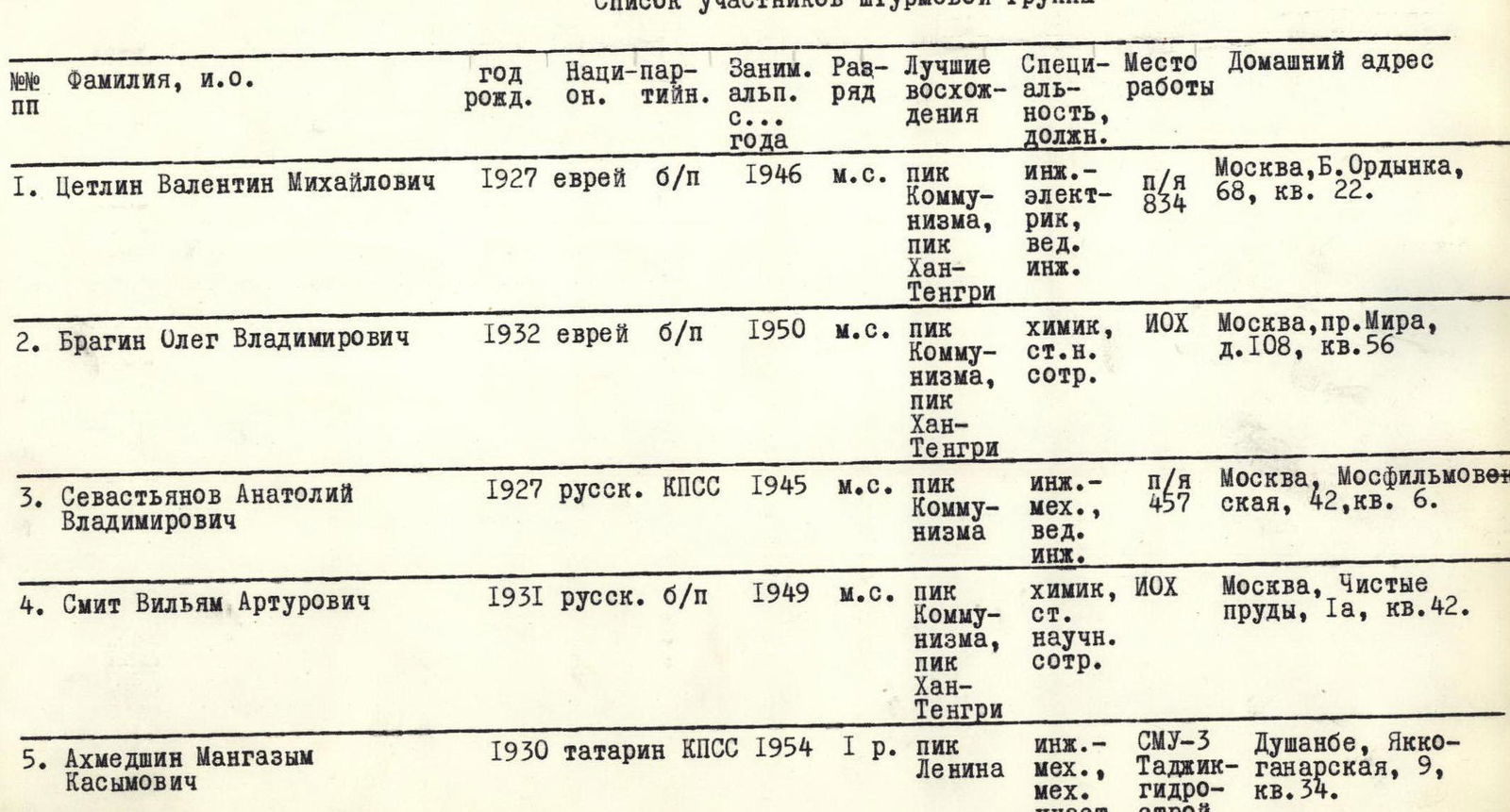
| № | Surname, initials | Year of birth | Nationality | Party membership | Climbing experience since | Category | Notable ascents | Specialty, position | Workplace | Home address |
|---|---|---|---|---|---|---|---|---|---|---|
| 1 | Tsetlin Valentin Mikhailovich | 1927 | Jewish | non-party | 1946 | Master of Sport | Peak Kommunizma, Khan-Tengri | Electrical engineer, lead engineer | p/o 834 | Moscow, B. Ordyanka, d. 68, kv. 22 |
| 2 | Bragin Oleg Vladimirovich | 1932 | Jewish | non-party | 1950 | Master of Sport | Peak Kommunizma, Khan-Tengri | Chemist, senior researcher | IOKh | Moscow, pr. Mira, d. 108, kv. 56 |
| 3 | Sevastyanov Anatoly Vladimirovich | 1927 | Russian | CPSU | 1945 | Master of Sport | Peak Kommunizma | Mechanical engineer, lead engineer | p/o 457 | Moscow, Mosfilmovskaya, d. 42, kv. 6 |
| 4 | Smit William Arturovich | 1931 | Russian | non-party | 1949 | Master of Sport | Peak Kommunizma, Khan-Tengri | Chemist, senior researcher | IOKh | Moscow, Chistye prudy, d. 1a, kv. 42 |
| 5 | Akhmedshin Mangazym Kasymovich | 1930 | Tatar | CPSU | 1954 | 1st sports category | Peak Lenin | Mechanical engineer, construction worker | S MU-3 Tajik. | Dushanbe, Yakko-ganaarovskaya, d. 9, kv. 34 |
| 6 | Dubinin Vadim Alekseevich | 1934 | Russian | non-party | 1951 | Master of Sport | Peak Kommunizma, Khan-Tengri | Physicist, senior engineer | p/o 2312 | Moscow, Izmailovsky blvd., d. 60/10, kv. 33 |
| 7 | Kalachev Lev Dmitrievich | 1926 | Russian | non-party | 1949 | 1st sports category | Peak Pravdy, traverse of Uzhba | Mechanical engineer, senior researcher | NAM I | Moscow, Majorov per., d. 4/6, kv. 26 |
| 8 | Kulikov Oleg Fedorovich | 1931 | Russian | non-party | 1952 | 1st sports category | Peak Kommunizma, Khan-Tengri | Physicist, junior researcher | MGU | Moscow, ul. Ogarova, d. 1/12, kv. 69 |
| 9 | Maksimov Viktor Nikolaevich | 1938 | Russian | non-party | 1957 | 1st sports category | Traverse of Uzhba | Mechanical engineer | p/o 2401 | Moscow, Volgogradsky pr., d. 58, korp. 3, kv. 28 |
| 10 | Shchegolev Igor Fomich | 1929 | Russian | CPSU | 1953 | 1st sports category | Khan-Tengri | Physicist, senior researcher | F IKhF M.O., | Chernogolovka, ul. 3, d. 4, kv. 1 |
When compiling the tactical ascent plan, serious attention was paid to: maximally easing the participants, ensuring high reliability and safety when traversing the route. The average weight of the daily ration did not exceed 700 g. A 4-person down sleeping bag was used. To unload the first two days of the ascent to a height of 5800 m, a 60-kg cache was made.
To keep the high-altitude boots dry, checkeltons were put on only at a height of 5075 m. An early exit on August 8 from camp 5075 m allowed the group to traverse almost the entire snowy-icy slope under the southwestern wall before it was illuminated by the Sun. As a result, everyone's footwear remained dry, and no participant's feet froze throughout the subsequent ascent. The exit on the 2nd day up the southern ridge 200 m higher than the planned bivouac site allowed for: significantly unloading the next day's ascent and resting well before the decisive summit push. The state of the snow, the good health of all participants, which allowed for maintaining a high rate of ascent in the previous days, provided a basis for deciding on a summit push from camp 6700 m.
The group members moved in two pairs and two triples. The pairs were: Tsetlin - Sevastyanov, Bragin - Smit; the triples were: Dubinin - Kalachev - Shchegolev and Kulikov - Akhmedshin - Maksimov. Rocky sections were typically first traversed by one of the pairs; on snowy-icy sections of the slope and ridge, all participants took turns going first. At bivouacs, everyone acted very actively. On the route, all participants demonstrated themselves to be very well-prepared both technically and physically.
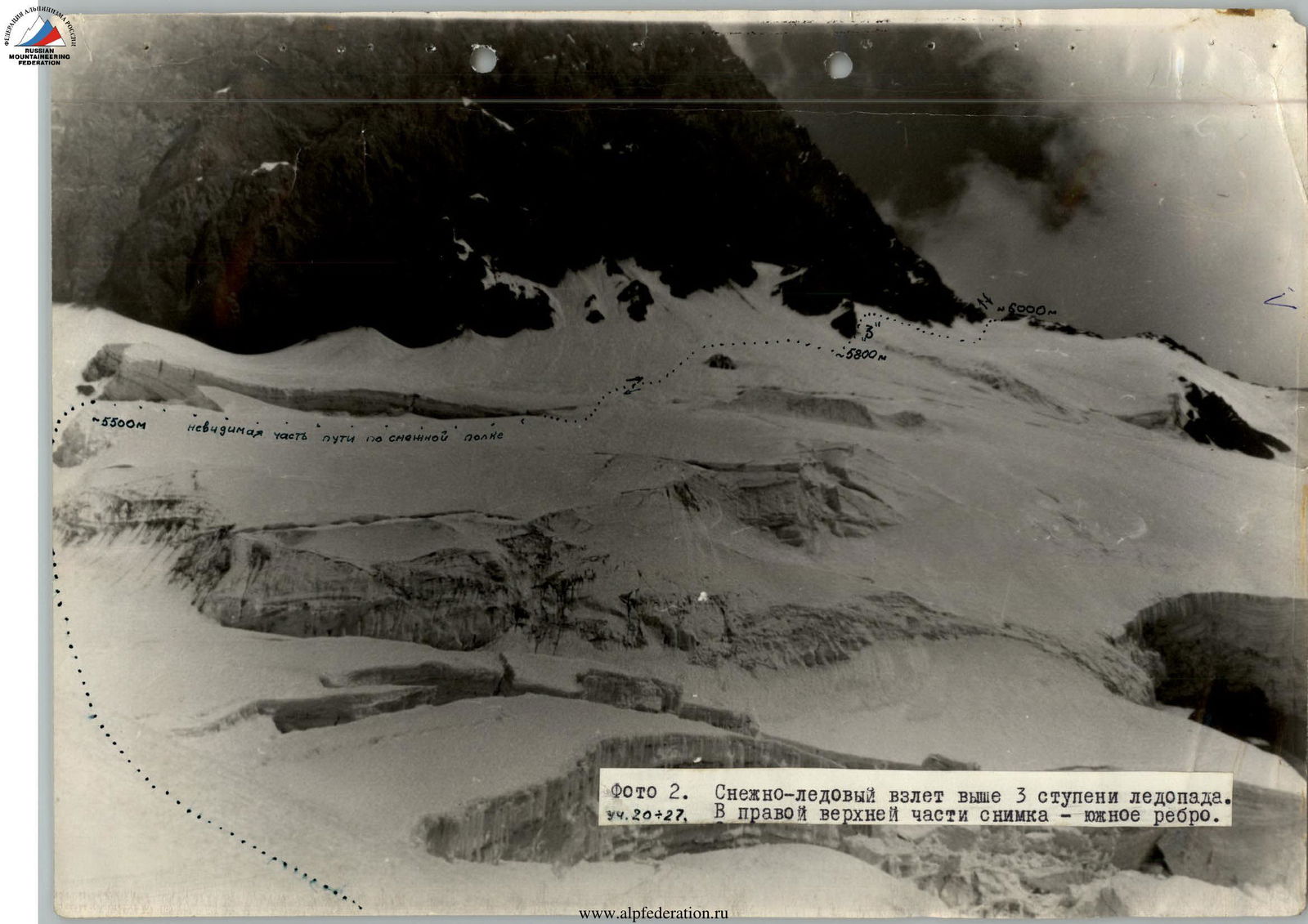
Photo 2. Snowy-icy ascent above the 3rd step of the glacier fall. Sections R20–R27. In the upper right part of the image - the southern ridge.
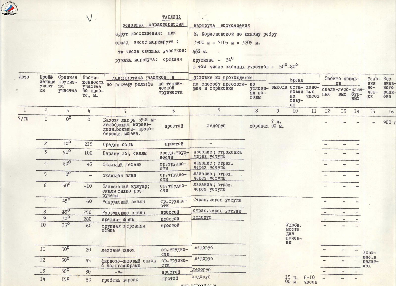
| Date | Section № | Average slope of the section | Height gain, m | Characteristics of sections by relief type | Characteristics of sections by technical difficulty | Conditions for their passage by method of overcoming and belaying | Weather conditions | Time of exit | Time of stopping at bivouac | Working hours | Hooks hammered: rock | Hooks hammered: ice | Hooks hammered: shlamburn | Bivouac conditions | Daily ration weight |
|---|---|---|---|---|---|---|---|---|---|---|---|---|---|---|---|
| 7/VIII | R1 | 0° | 0 | Base camp 3900 m - left-bank moraine of Moskvina glacier - right-bank moraine. | simple | Ice axe | good | 7:00 | 900 g | ||||||
| R2 | 10° | 215 | Medium talus slope | simple | Ice axe | ||||||||||
| R3 | 50° | 100 | Ram's foreheads, rocks | medium difficulty | Climbing; belaying through ledges | ||||||||||
| R4 | 60° | 45 | Rocky ridge | medium difficulty | Climbing; belaying through ledges | ||||||||||
| R5 | 0° | Rocky ledge | medium difficulty | Climbing; belaying through ledges | 1 | ||||||||||
| R6 | 50° | –10 | Snowy couloir; rocks heavily destroyed | medium difficulty | Climbing; belaying through ledges | ||||||||||
| R7 | 45° | 60 | Destroyed rocks | medium difficulty | Belaying through ledges | ||||||||||
| R8 | 50° | 250 | Destroyed rocks | simple | Belaying through ledges | ||||||||||
| R9 | 30° | 280 | Medium talus slope | simple | Ice axe | Convenient place for bivouac | |||||||||
| R10 | 15° | 60 | Large and medium talus slope | simple | Ice axe | ||||||||||
| R11 | 30° | 20 | Icy slope | medium difficulty | Ice axe | Good, in tents | |||||||||
| R12 | 50° | 45 | Firn-icy slope with calderas | medium difficulty | Ice axe | ||||||||||
| R13 | 30° | 30 | simple | Ice axe | |||||||||||
| R14 | 15° | 80 | Moraine ridge | simple | Ice axe | 15:00 (8–10 ч) | |||||||||
| 8/VIII | R15 | 30° | 30 | Glacier, below the 3rd step of the glacier fall | simple | Ice axe | good | 5:00 | 700 g | ||||||
| R16 | 40° | 150 | Glacier fall, closed glacier | medium difficulty | Movement on crampons, ice axe | ||||||||||
| R17 | 80° | 3 | Icy wall | difficult | Step-cutting, ice axe | ||||||||||
| R18 | 30° | 77 | Glacier fall, closed glacier | medium difficulty | Ice axe | ||||||||||
| R19 | 10° | 45 | Plateau | simple | Ice axe | ||||||||||
| R20 | 50° | 90 | Snowy-icy slope | medium difficulty | Ice screws, ice axe | 4 | Convenient place for bivouac | ||||||||
| R21 | 0° | Snowy ledge under the ledge | simple | Ice axe | |||||||||||
| R22 | 40° | 60 | Snowy-icy slope | medium difficulty | Ice axe | ||||||||||
| R23 | 30° | 125 | Traversing snowy-icy slope with height gain | medium difficulty | Ice axe | ||||||||||
| R24 | 40° | 90 | Snowy-icy slope, ascent to the cache site | medium difficulty | Ice axe | ||||||||||
| R25 | 50° | 45 | Porous ice with a rocky wall | difficult | Ice and rock screws, step-cutting | 1 | 2 | ||||||||
| R26 | 35° | 120 | Traverse with height gain of snowy-icy slope | medium difficulty | Ice axe | ||||||||||
| R27 | 45° | 80 | Snowy-icy slope, bergschrund, exit to southern ridge | medium difficulty | Ice axe | ||||||||||
| R28 | 15° | 20 | Sharp snowy ridge | simple | Ice axe | ||||||||||
| R29 | 60° | 30 | Icy rocks | difficult | Rock screws, ledges | 2 | |||||||||
| R30 | 20° | 45 | Snowy ridge | simple | Ice axe | strong wind, clouds, fog | Good bivouac in a cirque | ||||||||
| R31 | 45° | 80 | Snowy ridge, deep, loose snow | difficult | Ice axe | ||||||||||
| R32 | 15° | 50 | Snowy ridge, deep snow | simple | Ice axe | ||||||||||
| R33 | 40° | 75 | Ascent of snowy ridge, deep, loose snow | medium difficulty | Ice axe | ||||||||||
| R34 | 5° | 10 | Snowy cirque | simple | Ice axe | 17:00 (10–12 ч) | |||||||||
| 9/VIII | R35 | 40° | 80 | Ascent of snowy ridge | medium difficulty | Ice axe |