Committee for Physical Culture and Sports under the Council of Ministers of the Ukrainian SSR
Report on the ascent of Peak Kommunizma via the south face
 Kiev, 1973
I. Sports Characteristic of the Route
The object of the ascent, Peak Kommunizma, is located at the junction of the Petra Pervogo and Akademii Nauk ranges in the Central Pamir. After E. M. Abalakov's first ascent of Peak Kommunizma in 1933, a large number of new routes were laid to its summit. The area around Peak Kommunizma is frequently visited by mountaineering expeditions and is fairly well-known both geographically and in terms of mountaineering. (See "Pobezhdennye vershiny" 1968–1969.) Following the brilliant reconnaissance by V. Bozhuukov and A. Belopukhov in 1965, and the successful ascents by the groups led by E. Myslovsky and V. Onishchenko, the central part of the south face of Peak Kommunizma became one of the main challenging routes for Soviet mountaineers.
Our team's acquaintance with Peak Kommunizma began in 1967 when we made the first ascent of its northeast ridge, earning the title of USSR champions. In 1972, we attempted to ascend via the center of the south face. Due to harsh weather conditions and time constraints, we were forced to descend, having reached an altitude of 6300–6400 m.
II. Preparation for the Ascent, Information about the Sports Group
The team from the Ukrainian Sports Committee was primarily composed of mountaineers from the UkrSoviet DSO "Spartak". The team also included mountaineers from the Kharkov DSO "Avangard".
Overall leadership of the expedition was carried out by A. Kustovsky, who had headed the Ukrainian "Spartak" team for many years. All team members had participated in the USSR mountaineering championships for several years. Three members had previously been on Peak Kommunizma (Kustovsky, Cherevko, Kolesnik). Two were three-time USSR champions (Kustovsky, Cherevko), and five had achieved this high title once:
- Aleksyuk
- Grigorenko-Prigoda
- Bakhtigozin
- Tkachenko
- Kolesnik
All participants undergo year-round training, ensuring a sufficiently high level of physical fitness by the start of the season.
In addition to physical preparation, we continually improve our technical skills and equipment. This year, in particular, we did a lot of work on manufacturing down-filled gear from calendered nylon, which allowed us to have:
- sleeping bags weighing 1.2–1.4 kg;
- down jackets weighing 0.6–0.8 kg.
A significant amount of time and effort was spent preparing individual nutrition rations.
It is worth noting that we have organized individual nutrition for participants since 1962–1963, and it has fully justified itself by:
- saving time on the route;
- ensuring regular nutrition for all participants;
- providing nutrition on sections of any complexity.
III. Organizational and Tactical Plan for the Ascent
The organizational plan for the ascent included:
- Gathering all participants in Dushanbe by July 5.
- Relocating the expedition to the Garmo glacier using helicopters and establishing a base camp on Surkovaya Polyana (altitude 3900 m) by July 10.
- Transporting cargo by helicopter under the wall, setting up a storm camp at "Gruzinskie nochevki" (altitude 4700 m), conducting acclimatization climbs, organizing preventive and rescue measures, ascending, evacuating, and concluding the expedition's work by August 20.

| № | Full Name | Sports Rank | Year of Birth | DSO | Mountaineering Experience | Profession | Address | |:--|:------------------------------|:----------|:----------|:------------|:----------|:----------|:------------------------------------:|------------------------------|:----------|:----------|:------------|:----------|:----------|:------------------------------------| | 1. | Kustovsky Anatoly Alekseevich (leader) | MS | 1925 | "Spartak" | 1949 | engineer | Kiev, B. Druzhby narodov, 28 "a", kv. 14 | | 2. | Cherevko Vladimir Leonidovich (deputy leader) | MS | 1934 | — | 1953 | — | Kiev, Elektro-technichesky per., d. 7/11, kv. 50 | | 3. | Kolesnik Vasily Vasilyevich | MS | 1939 | — | 1958 | — | Kiev, Pushkina 11, kv. 10 | | 4. | Aleksyuk Mikhail Mirovich | MS | 1932 | "Avangard" | 1949 | — | Kiev, Entuziastov 19/1, kv. 15 | | 5. | Palamarchuk Valery Nikolaevich | CMS | 1945 | "Spartak" | 1960 | — | Kiev, Zodchikh 26, kv. 38 | | 6. | Mazarchuk Mikhail Andreevich | CMS | 1943 | — | 1962 | locksmith | Kiev, Kulibina 9/2, kv. 65 | | 7. | Shalygin Anatoly Alekseevich | MS | 1939 | — | 1954 | engineer | Kharkov, bl. Mira 2, kv. 77 | | 8. | Grigorenko-Prigoda Yuri Ivanovich | MS | 1935 | "Avangard" | 1953 | lecturer | Kharkov, Moskovsky pr., 216, kv. 74 | | 9. | Bakhtigozin Vitaly Alekseevich | MS | 1937 | — | 1962 | engineer | Kharkov | | 10. | Tkachenko Vladimir Semenovich | MS | 1939 | — | 1964 | — | Kharkov, pr. Lenina 24, kv. 49 |
The expedition began on August 20. The main stages of this plan were executed within the scheduled timeframe. After setting up the base camp, the entire expedition team headed to "Gruzinskie nochevki", where a tent was installed, and a storm camp was organized.
Under the wall, at an altitude of 5000–5100 m, two high-altitude tents were set up with equipment and food supplies.
Prior to the ascent, a second acclimatization climb was conducted, during which each team member ascended to an altitude of 6000–6200 m and spent the night there. The acclimatization climb was combined with:
- processing the lower part of the route;
- transporting part of the food supplies.
Preventive and rescue measures were ensured by the expedition's forces. Interaction was also established with groups of mountaineers from Leningrad "Spartak" and Nurek, working in the area.
The expedition had:
- stable communication with Tavil-Dar'a airport using a "Nedra" radio station;
- communication between the base camp, "Gruzinskie nochevki", and the wall using "Vitalka" radio stations.
It was deemed expedient to take two "Vitalka" radio stations for the ascent to ensure radio communication within the group, which later proved to be extremely convenient and useful.
The tactical plan for the ascent, developed before leaving for the mountains based on the 1972 expedition's results, was refined according to the conditions of that year.
The central part of the south face of Peak Kommunizma is a complex, rocky route that is steep in the central part. The main challenging sections are located at altitudes around 7000 m and above.
The left part is hazardous due to:
- a hanging serac;
- rockfall from the ridge connecting Peak Kommunizma and Peak Kuibyshev.
The right part, having the least steepness and length, is traversed by the routes of E. Myslovsky and V. Onishchenko.
The central part resembles a giant external corner with a "hanging" section at the bottom.
Thus, the following tactical plan for the ascent emerged:
- Conduct the ascent via the center of the south face, following the right edge of the external corner.
- Have the group preliminarily process the lower part of the route with cargo and equipment transport.
- Conduct the ascent with the full team (10 people), planning for a climb duration of up to 15 days, followed by a descent via the Nekrasov route.
- Despite having wall-base camp communication, maintain observers at "Gruzinskie nochevki".
IV. Description of the Ascent
July 27. The route begins from the plateau under the south face, located at an altitude of 5000–5100 m. Initially, the ascent goes along the first left rock "claw". The rocks are relatively simple, with 4–5 pitons hammered into a 60 m rope (section R0–R1). Upon examining the route and initial processing, the rockfall pattern is determined, which typically starts here around 11:00–12:00. Therefore, we depart at 5:00 AM with the dawn.
The first five members cross the rockfall-prone couloir and reach the triangle, while the second five, for whom a platform is prepared for overnight stay in the upper part of the "claw", depart from "Gruzinskie nochevki".
By 14:00–15:00, we reach the overnight stay locations. Everything goes according to plan, the pace is high, and the weather is excellent. The R0–R1 section has significantly less snow than in 1972. Altitude 5600 m.
July 28. On this day, the first five members pass the R1–R2 section under the rock "triangle" and continue upward along fairly steep rocks (backpacks are pulled up), reaching point R3, where a spot is prepared for two tents. The second five members only reach point R1 from their overnight stay, where they spend the night at the same location as the first five's first night.
All sections covered over the two days were traversed somewhat slower in 1972. Altitude 5750 m.
July 29. Today, a lot of work is done to "free" the ropes used in the previous days. Thus, for the entire day, we manage to process five ropes to the right and upward, crossing the rockfall-prone gully. In the first half of the day, we gather together, setting up two tents at point R3.
We have a lot of ropes: 12 × 60 m, which gives us some freedom in movement. We assume that not all of them will be needed in the upper part of the wall. Altitude 5900 m.
July 30. A challenging day. We need to traverse the section processed yesterday and reach the top of the "triangle" — a safe location where tents can presumably be set up. This spot is also convenient for further overcoming the "zigzag" — a white quartz band tracing the central part of the wall from right to left.
By 16:00, pulling up backpacks on several sections, we reach point R4 at the top of the "triangle". On this day, we ascend a few more ropes upward. We frequently change the lead climber, conserving energy for the upper part of the wall. On sections R0–R4, the lead was taken alternately by:
- Grigorenko-Prigoda,
- Kolesnik,
- Bakhtigozin,
- Shalygin,
- Cherevko.
Altitude 6100 m.
July 31. A day of complex climbing. Almost vertical sections (R4–R5) lead left and upward to the overhanging part (R5–R6). Ladders are used. Several pitons are hammered in (not used later). Climbers on the rope use "jumar" clamps for ascent.
By the end of the day, Cherevko and Tkachenko manage to traverse the quartz band and reach an inclined ledge where rucksacks can be pulled up the next day. By linking two ropes (a section with a negative slope of 80 m), we descend for the night to point R4. Altitude 6250 m.
August 1. On this day, we traverse the previously processed sections R4–R5 and R5–R6 and organize a sitting overnight stay at point R6. We work for over 14 hours. The availability of radio communication within the group greatly aids in movement and rucksack transport. Altitude 6350 m.
August 2. The significant work done yesterday allows us to "catch up on our supplies": all equipment is now available, and all participants are gathered in one place. This enables us to gain a considerable altitude — about 300 m — on this day. We move left and upward. The risk of rockfall has decreased significantly. The weather is good, and the rocks are warm. The steepness of the rocks is 75–85°.
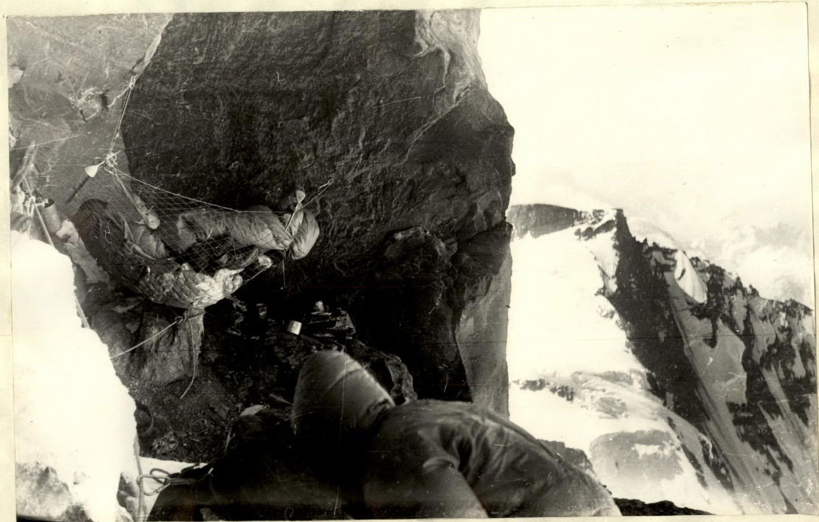
Using piton protection and pulling up the trailing climber's rucksack with a rope, we quickly gain altitude. On this day, we slightly ahead of the movement schedule but fail to release the pitons, carabiners, and ropes for further movement by the end of the day. The overnight stay is in a sitting position, with some participants using hammocks. Altitude 6500 m.
August 3. A pair, having gathered all available equipment, moves upward. They are to be replaced by another pair later. If a suitable overnight location is found, we will all move up; otherwise, we decide to process another 250–300 m upward — we're not keen on changing our overnight spot, having grown accustomed to our sitting arrangement.
Climbing is challenging.
We overnight again at point R8. Altitude 6650 m.
August 4. We traverse the section processed the previous day. Working is tiring; the altitude is felt. The rocks are reminiscent of Caucasian walls. To ease movement with a rucksack, we frequently use ladders.
We're roughly at the level of the Kuzmin ridge route. However, due to overhanging rocks, the exit is not visible. By the end of the day, the steepness of the rocks gradually decreases. Snowy sections and a snowy ledge are visible. The route of E. Myslovsky's group likely passes somewhere here.
We manage to set up one tent along the wall. Five people spend the night in a sitting position. Altitude 6850 m.
August 5. We ascend left and upward along rocks with a platy structure. The steepness decreases. The pre-summit ridge is visible. The first climber goes without a rucksack; the rest move with rucksacks.
We cover eight ropes by the end of the day. The overnight stay is at point R10, with three people in two tents and a sitting overnight stay for the rest. Three ropes are hung upward. Altitude 7000 m.
August 6. We move upward along the processed section and then slightly to the right.
Climbing is not extremely challenging but is complicated by the altitude. Overall, the physical strain is quite high.
By the end of the day, A. Kustovsky complains of:
- difficulty breathing;
- pain in the heart area.
We relieve him of his load, and he independently reaches point R12, where we set up two tents some distance apart.
We contact the base camp and, following a doctor's recommendations, provide Kustovsky with necessary assistance.
From the tents, about 60 m higher, the exit to the pre-summit ridge of Peak Kommunizma is visible. Altitude 7150 m.
August 7. We're in a hurry to reach the ridge as soon as possible. Kustovsky's health is a concern. Additionally, Grigorenko-Prigoda has a cold.
We release the equipment on the sections traversed the previous day.
By 15:00, the pair Cherevko-Tkachenko reaches the pre-summit ridge. On the ridge, there's strong wind, and there are no suitable spots for tents. If we had ascended with the entire group that day, we likely couldn't have descended to a lower altitude than point R12 for the night. Therefore, we decide to spend the night at R12 to descend as low as possible the next day after reaching the ridge and summit.
At night, we follow all the doctor's recommendations regarding Kustovsky and Grigorenko-Prigoda. We discuss the plan for the next day with Kustovsky.
But during the night, the unthinkable happens. Kustovsky's breathing stops. Artificial respiration and closed heart massage are unsuccessful. Altitude 7225 m.
August 8. Everyone is depressed. Nevertheless, we must continue. The only possible way to transport Kustovsky is along the ridge leading from the saddle between Peak Kommunizma and Peak Pravdy.
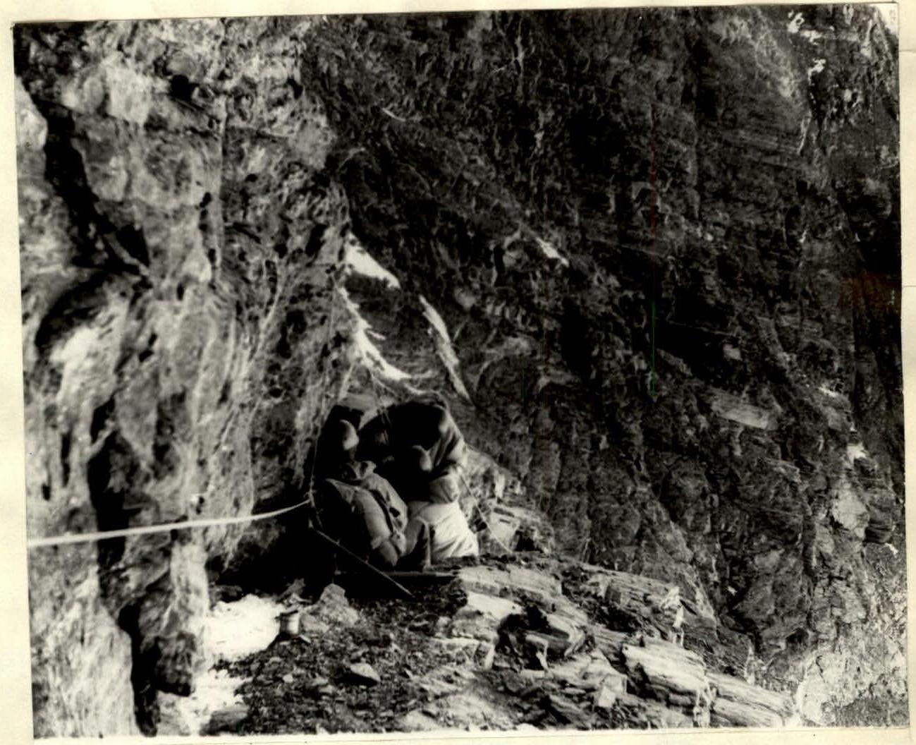
The rocky section on the path to the "triangle" summit (section R2–R3).
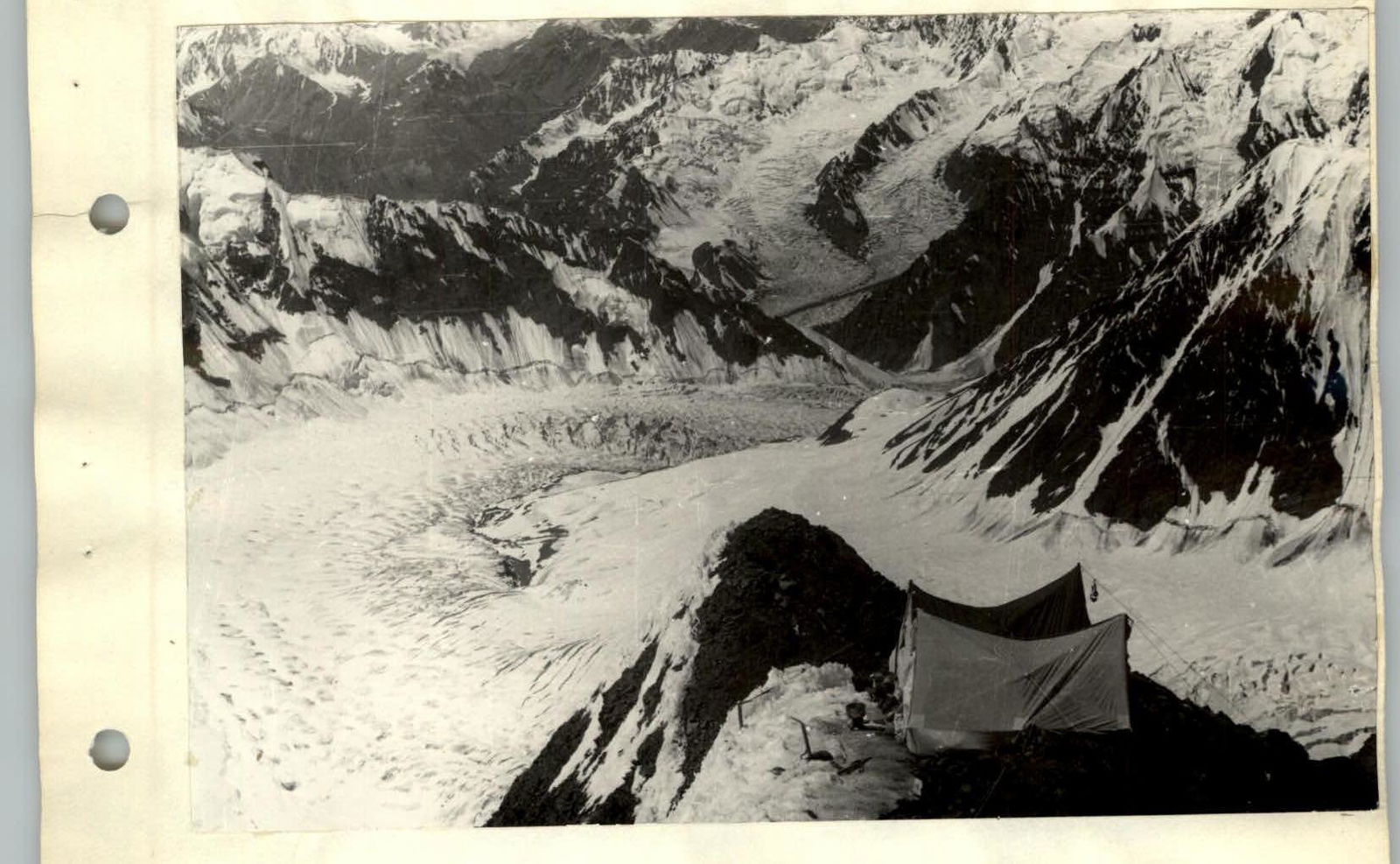
The "triangle" summit (point R4). View of the Biwachny glacier.
Overnight stay at an altitude of about 7000 m. Up to the ridge — 60 m in height, rocks of moderate complexity with short steep wall sections (section R12–R13). Altitude 7300 m. Initially, we decide to transport Kustovsky's body down to the plateau with the group's forces. We ascend to the ridge (the climb for the entire group took about 4 hours), leave a memorial note on the summit detailing everything that happened (the ascent along the ridge to the summit took 20–30 minutes). Grigorenko-Prigoda's health is causing us increasing concern. His cough, overall weakness, and the risk of pneumonia at high altitude force us, after consulting with a doctor via radio, to begin descending, temporarily burying Kustovsky at the overnight stay at point R12. We spend the night at an altitude of about 7200 m.
August 9–14.
These days are required for descending via the Nekrasov route to "Gruzinskie nochevki". At an altitude of about 5700 m, we are met by mountaineers from Nurek, who help Grigorenko-Prigoda descend. We reciprocate by bringing equipment and warm clothing from the "cache" they had prepared for their canceled ascent of Peak Kommunizma. From "Gruzinskie nochevki", all participants are transported to Jargital by helicopter.
VI. Evaluation of the Route and Participants' Actions
During the preparation for the ascent of Peak Kommunizma, our team carried out an extensive program of physical and technical training.
As a result of the work done, the enormous organizational efforts of the team captain A. Kustovsky, and the clear and purposeful actions of all team members, a complex high-altitude wall route was traversed.
The route taken by the team via the center of the south face of Peak Kommunizma is a logical, beautiful, and interesting path to the summit in terms of mountaineering.
The team's experience with complex high-altitude and wall ascents allows us to consider this route as category 6B complexity.
On behalf of the team, Deputy Team Leader
 (V. Cherevko)
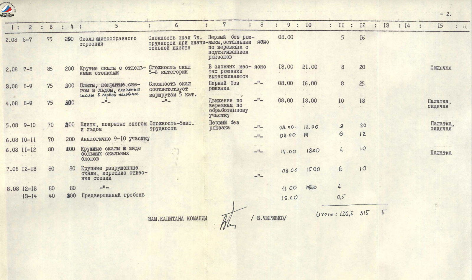
Table of Main Characteristics of the Route via the South Face of Peak Kommunizma
Height difference on the route 2500 m Including the most complex sections 1500 m Steepness of the route 75°
| Date | Section | Average Steepness | Length | Characteristics of Sections and Conditions of Passage | Weather | Time of Departure | Overnight Stay | Climbing Hours | Pitons Driven (Rock) | Pitons Driven (Ice) | Pitons Driven (Bolts) | Overnight Conditions |
|---|---|---|---|---|---|---|---|---|---|---|---|---|
| By Relief | By Technical Difficulty | By Method of Overcoming and Insurance | ||||||||||
| 27.07 | R0–R1 | 50 | 700 | Border of rocks and ice, rocks like "barany lby," separate ice sections, short rock walls | clear | 5:00 | 15:00 | 10 | 40 | — | 3 | Tent |
| 28.07 | R1–R2 | 40 | 300 | Traverse under the base of the "triangle" along smooth rocks. Risk of rockfall at R2 | — | 7:00 | — | 5 | 24 | — | — | — |
| 28.07 | R2–R3 | 80 | 200 | Steep, solid rocks, rime ice. | — | 18:00 | — | 6 | 26 | — | — | Tent |
| cat. diff. 5 | First without rucksack with piton insurance. Rucksacks pulled up. | |||||||||||
| 29.07 | R3–R4 | 70 | 300 | Destroyed rocks, edge of ice and rocks, separate walls 4–5 m. | — | 8:00 | 16:00 | 8 | 24 | — | — | Tent |
| cat. diff. 5 | First without rucksack | |||||||||||
| 30.07 | R3–R4 | 70 | 300 | — | — | 7:00 | 17:00 | 10 | — | — | — | Tent |
| cat. diff. 5 | Movement with rucksacks along ropes. On complex sections, rucksacks pulled up by rope. | |||||||||||
| 31.07 | R4–R5 | 80 | 200 | Smoothed rocks with loose stones | — | 7:00 | — | 5 | 40 | — | — | — |
| cat. diff. 5–6 | First without rucksack with piton insurance | |||||||||||
| 31.07 | R5–R6 | 95 | 100 | Overhanging section at the intersection of the quartz band | — | 12:00 | 20:00 | 8 | 30 | — | 5 | Tent |
| cat. diff. 6 | Artificial supports used, rucksacks pulled up | |||||||||||
| 01.08 | R4–R5 | 80 | 200 | — | clear | 7:00 | 21:00 | 14 | — | — | — | Sitting |
| R5–R6 | 95 | 100 | — | — | 9:00 | 18:00 | 9 | — | — | — | — | |
| 8:00 | 12:00 | 6 | 12 | — | — | |||||||
| cat. diff. 5 | Movement along rope on "jumar" clamps and with artificial supports | |||||||||||
| 2.08 | R6–R7 | 75 | 200 | Rocks with a platy structure | clear | 8:00 | — | 5 | 16 | — | — | — |
| cat. diff. 5 | First without rucksack, others on ropes with rucksack pull-up | |||||||||||
| 2.08 | R7–R8 | 85 | 200 | Steep rocks with separate walls | clear | 13:00 | 21:00 | 8 | 20 | — | — | Sitting |
| cat. diff. 5–6 | In complex places, rucksacks pulled up | |||||||||||
| 3.08 | R8–R9 | 75 | 300 | Plates covered with snow and ice, complex rocks in the first half | — | 8:00 | 16:00 | 8 | 25 | — | — | — |
| cat. diff. 5 | First without rucksack | |||||||||||
| 4.08 | R8–R9 | 75 | 300 | — | — | 8:00 | 18:00 | 10 | 18 | — | — | Tent, sitting |
| cat. diff. 5 | Movement along ropes on processed section | |||||||||||
| 5.08 | R9–R10 | 70 | 200 | Plates covered with snow and ice | — | 9:00 | 18:00 | 9 | 20 | — | — | Tent, sitting |
| cat. diff. 5 | First without rucksack | |||||||||||
| 6.08 | R10–R11 | 70 | 200 | Similar to R9–R10 section | — | 8:00 | 12:00 | 6 | 12 | — | — | — |
| cat. diff. 5 | — | |||||||||||
| 6.08 | R11–R12 | 80 | 100 | Large rocks in the form of big rock blocks | — | 14:00 | 18:00 | 4 | 10 | — | — | Tent |
| cat. diff. 5 | — | |||||||||||
| 7.08 | R12–R13 | 80 | 80 | Large destroyed rocks, short steep wall sections | — | 8:00 | 15:00 | 6 | 10 | — | — | — |
| cat. diff. 5 | — | |||||||||||
| 8.08 | R12–R13 | 80 | 80 | — | — | 11:00 | 15:00 | 4 | — | — | — | — |
| R13–R14 | 40 | 300 | Pre-summit ridge | — | 15:00 | — | 0.5 | — | — | — | — |
Total: 126.5 / 315 / 5 DEPUTY TEAM LEADER V. CHEREVKO