Passport
-
Altitude class
-
Central Pamir, Peter the First and Academy of Sciences ranges.
-
Traverse of Peak Xoxlova – Peak Kommunizma via the right NE buttress from the Balthazar Glacier.
-
First ascent, approximately 6A cat. dif.
-
Elevation gain: 2895 m, length of the main part 1520 m. Length of sections with 5–6 cat. dif.: 315 m. Average steepness of the main route: 57°, including 160 m of 6 cat. dif.
-
Pitons driven: Rock — 134, chocks — 53, ice screws — 51, bolt pitons — 0
-
Team's total climbing hours: 46 hours and 4 days.
-
Overnight camps: 1st — a platform built from stones on a rock shelf, 2nd — a platform carved in a snowy ridge, 3rd — a snow depression on a plateau. All overnight camps were lying-down bivouacs.
-
Leader: Fedorov Yury Semyonovich, Candidate Master of Sports
Team members:
- Bozhukov Grigory Nikolayevich, Candidate Master of Sports
- Bugachevsky Igor Borisovich, Candidate Master of Sports
- Zhilin Nikolay Fedorovich, Candidate Master of Sports
- Mikhailov Andrey Vladimirovich, Candidate Master of Sports
- Osipova Tatyana Alekseyevna, Candidate Master of Sports
- Fedorov Vyacheslav Anatolyevich, Candidate Master of Sports, 1st class. Coach: Mikhailov Alexander Alexandrovich
-
Departure to the route: August 4, 1990.
Summit — August 7, 1990, return — August 8, 1990.
-
Organization: Sverdlovsk Regional Sports Committee.
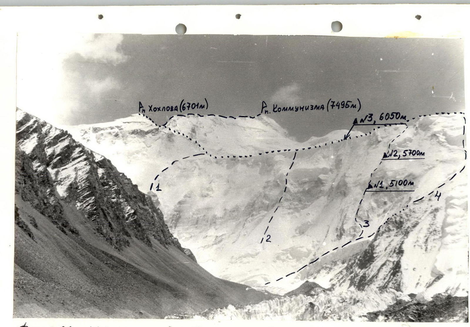
Photo 1. General view. 1st route by V. Bezzubkin: traverse of Xoxlova – Kommunizma with a counterfort from the Balthazar Glacier, 1971, 6A cat. dif. 2nd route by Chochis, 1984, 5B cat. dif. 3rd route climbed by the team. 4th route by Borodkin, 6A cat. dif. Photo taken from the base camp on Peak Moskvina (4200 m) on August 5, 1990.
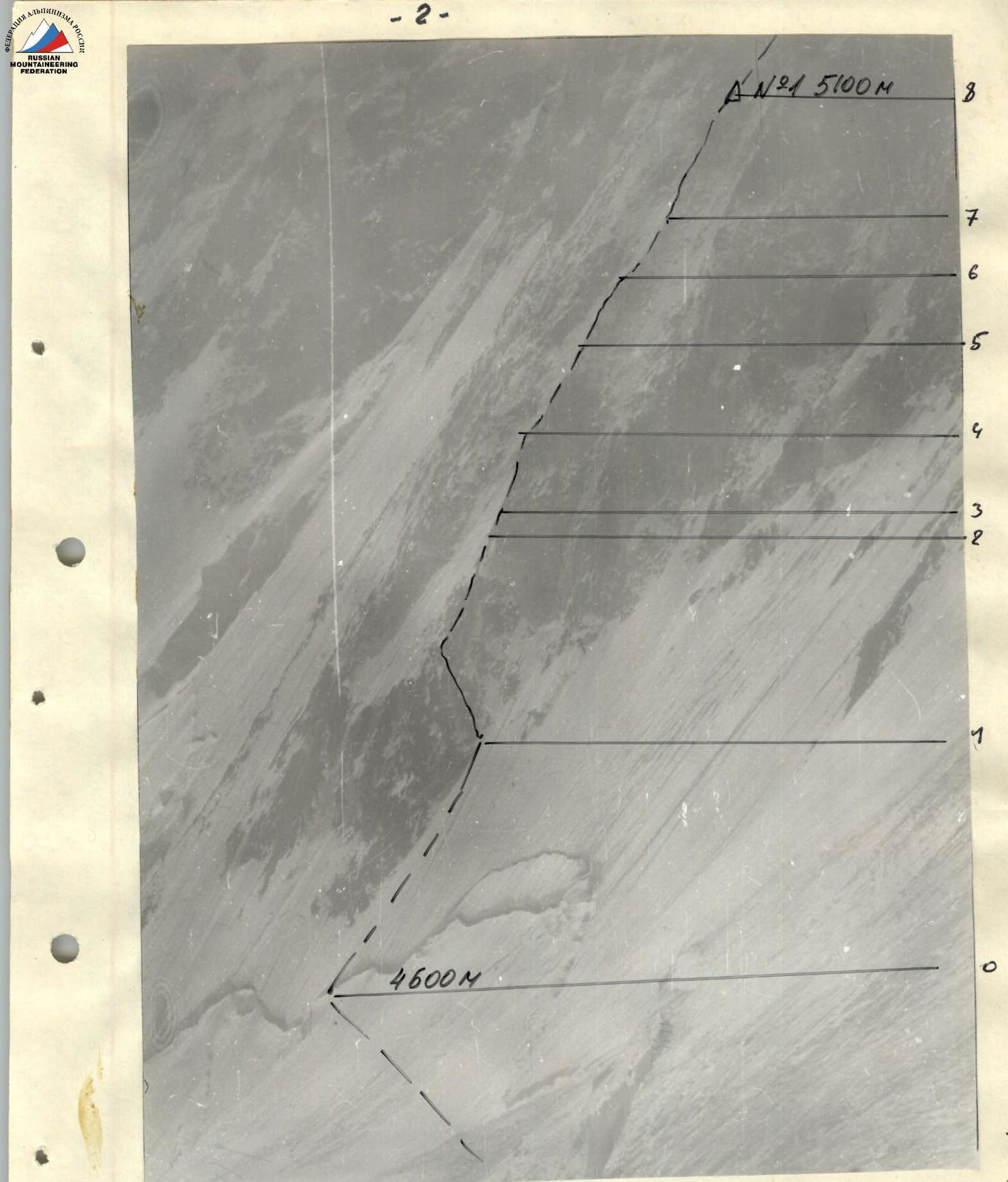
Photo 2. Profile on the right. Taken from Borodkin's route. Distance — 1 km. 4300 m, August 6, 1990.
Tactical Actions of the Team
When developing the tactical plan, the team considered materials obtained from the Tajikistan KSP and the results of their own observations, as well as their experience from ascending via Bezzubkin's route on Peak Kommunizma in 1986. Two variants of a timeline for the team's movement were developed — one for satisfactory and one for complicated climbing conditions.
The first day of the ascent went according to plan. There was a slight delay in movement due to a nighttime snowfall and deep fresh snow (reached the planned overnight camp at 20:30). On the second day, they worked strictly according to plan. On the third day, they completed the route to the Pamir Firn Plateau. They decided to make an overnight camp on the plateau instead of on the Xoxlova – Kommunizma col due to the slushy snow conditions on the slopes of Peak Xoxlova. This allowed them to conserve strength and ensure greater safety when ascending Peak Xoxlova early the next morning. On the fourth day of the ascent, as planned, they summited Peak Kommunizma, reaching Peak Xoxlova at 10:30. They reached the summit of Peak Kommunizma at 18:30.
The team's members had a fairly uniform level of technical and physical preparedness. On the first day, August 4, A. Mikhailov (completed sections R0–R1) and Fedorov V. (sections R2–R7) worked at the front of the route; on August 5, Bugachevsky I. (sections R8–R10) and Fedorov Yu. (sections R11–R13); on August 6, Bugachevsky I. (sections R14–R17). Sections R18–R22 were climbed simultaneously.
The first climber moved on a double rope, one of which was UIAA-certified. The second rope was used to set up belays. All other team members ascended using the fixed rope with two ascenders and additional upper or lower belays. Backpacks were not pulled but carried on their backs, thanks to the use of two ascenders. On steep and overhanging sections, backpacks were clipped under the climber. The route was primarily climbed using free climbing techniques. The first climber typically moved in crampons. There were no falls during the ascent. Hot meals were provided in the morning and evening; on the plateau and cols, a high-calorie snack was provided during the day. All overnight camps were lying-down bivouacs, set up in the safest locations — on ridges, away from walls, to minimize the risk of spontaneous rockfall.
During the ascent, new samples of safety and bivouac gear were used: "friend" type chocks, hexagonal cams, an arched high-altitude frame tent, ice axe leashes (known as "ice fifis" or "ice hooks"), and ice screws.
Throughout the ascent and descent, stable radio communication was maintained with observers.
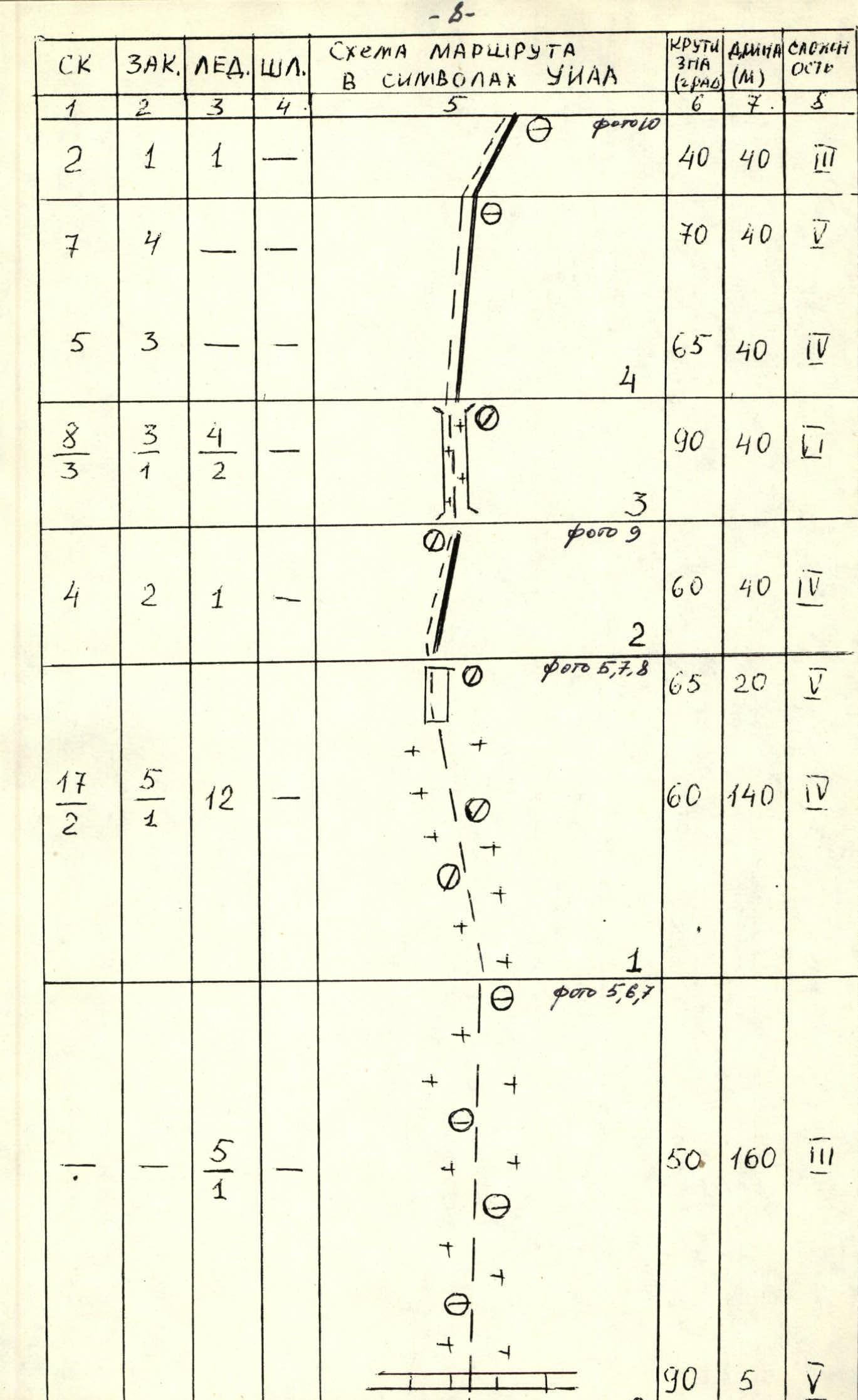
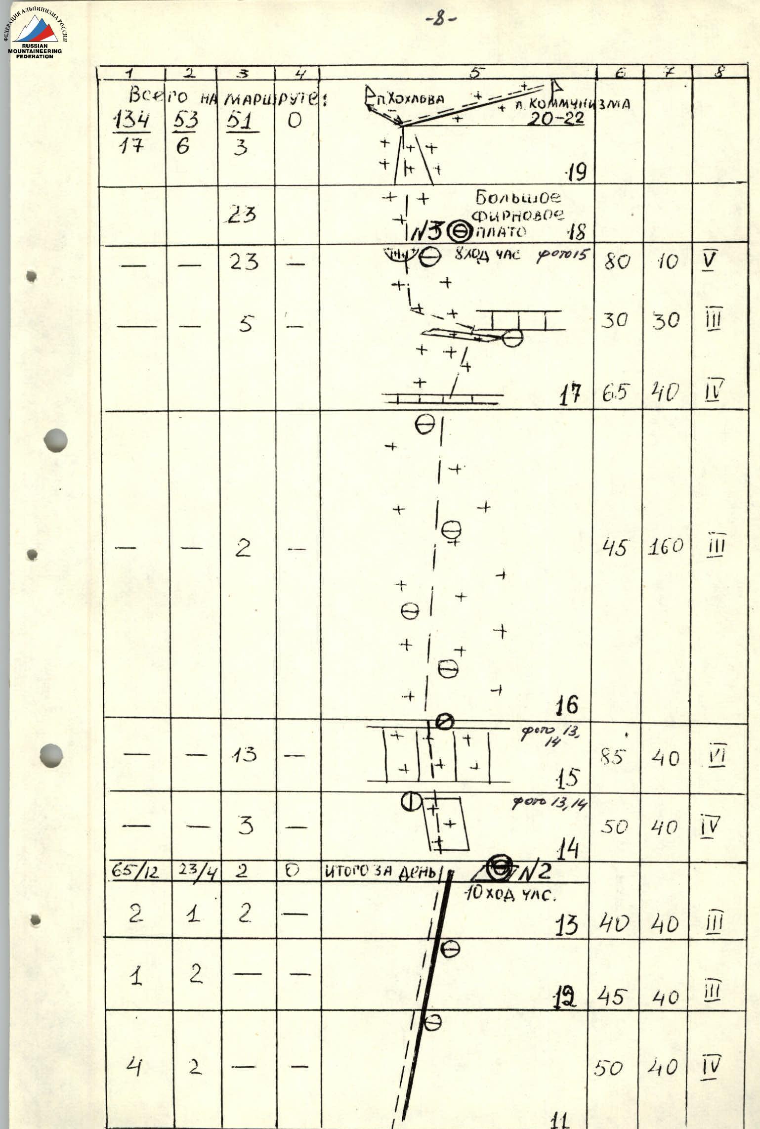
| Section | Rock Pitons | Chocks | Ice Screws | Bolt Pitons | Steepness (°) | Length (m) | Cat. dif. | Notes |
|---|---|---|---|---|---|---|---|---|
| R0 | - | - | - | - | - | - | - | |
| R1 | 2 | 1 | 1 | - | 40 | 40 | 3 | (photo 10) |
| R2 | 7 | 4 | - | - | 70 | 40 | 4 | |
| R3 | 5 | 3 | - | - | 65 | 40 | 4 | |
| R4 | 8 | 3 | 4 | - | 90 | 40 | 3 | |
| R5 | 3 | 1 | 2 | - | ||||
| R6 | 4 | 2 | 1 | - | 60 | 40 | 4 | (photo 9) |
| R7 | 17 | 5 | 12 | - | 65 | 20 | 5 | (photos 5,7,8) |
| R8 | 2 | 1 | - | - | ||||
| R9 | - | - | 5 | - | 50 | 160 | 3 | (photos 5,6,7) |
| (Continuation of R9) | - | - | 1 | - | 90 | 5 | 5 | |
| R10 | 1 | 1 | - | - | 45 | 40 | 3 | |
| R11 | 6 | - | - | - | 56 | 40 | 4 | |
| R12 | 5 | 1 | - | - | 60 | 40 | 4 | (photos 11, 12) |
| R13 | 8 | 3 | - | - | 65 | 40 | 5 | |
| R14 | 12 | 7 | 3 | - | 80 | 40 | 6 | |
| R15 | 17 | 2 | 1 | - | 85 | 40 | 6 | |
| R16 | 8 | 4 | - | - | 70 | 40 | 5 | |
| R17 | 69 | 30 | 26 | - | N1 (0) 15 climbing hours. | |||
| R18 | 5 | 2 | 3 | - | ||||
| R19 | 21 | 8 | 2 | - | 55 | 160 | 4 | |
| R20 | 3 | 3 | 1 | - | 40 | 40 | 4 | (photo 10) |
| R21 | 2 | 1 | - | - | 35 | 40 | 3 | (photo 10) |
| R22 | 4 | 2 | - | - | 50 | 40 | 4 | |
| Total on the route | 134 | 53 | 51 | 0 | - | - | - |
Description of the Route by Sections
General characteristics of the route: the route follows the Northeast buttress from the Balthazar Glacier. This buttress is located to the left of Borodkin's ridge and is the most pronounced of the three closely located buttresses in its middle part. A landmark for the route is a long ice couloir with large ice icicles (about 40 m) in its middle part. This couloir is to the left of the route.
All sections of IV–VI cat. dif. were climbed as follows:
- The first climber went without a backpack on a double rope, one of which was UIAA-certified, and set up belays.
- The other participants climbed the sections with backpacks, using two ascenders and having upper belays.
- The third climber ascended the belays with lower insurance, clipping the safety rope (UIAA) into already organized belay points. The first climber moved on a double rope, one of which was UIAA-certified.
Section R0. Snow bridge over the bergschrund and then — a snow-ice slope. Movement is to the right, bypassing the extremity of the rock island, in crampons. Insurance is through ice screws. In the lower part, through ice axes.
Sections R1–R7. The rocks in the lower part of the buttress are heavily snow-covered and icy. Rock and ice pitons and chocks are used for insurance. Climbing is difficult. Organizing reliable belay points is complicated by the iciness of the rocks. All climbers move in crampons.
Overnight camp on a rock shelf on the left side of the buttress. The overnight camp is a lying-down bivouac. The shelf size is 1.7 m × 2.0 m.
Sections R8–R9. Key section. Steep rock bastion. Due to the steepness, the section is lightly snow-covered. The first climber can work in rock shoes with warm socks or boots.
The rocks are initially composed of monolithic marbles, followed by a black zone of fragile sandstone. Organizing insurance is complicated by the fragility of the rocks. Insurance is mainly through rock pitons.
Sections R10–R13. After the bastion, a well-defined ridge of the buttress continues. Movement along the left part of the ridge is simpler but has many loose rocks. Insurance is through:
- pitons
- chocks.
Overnight camp on a snowy ridge — a convenient platform. The overnight camp is a lying-down bivouac.
Section R14. Ice slope. Insurance is through ice screws.
Section R15. Key section — ice wall. The first climber moves using ice axe leashes. Insurance is through ice screws.
Section R16. Snow slope. Can be avalanche-prone with heavy snowfalls. Insurance is through ice axes and a shovel.
Section R17. Ice wall with a snow cornice — exit to the Pamir Firn Plateau. Insurance is through ice screws.
Sections R18–R22. Movement across the plateau and ascent to the summits of Peak Xoxlova and Peak Kommunizma follows the traditional path via the col between these peaks. The ascent to the col was complicated by a lack of snow and occurred on a rock-ice slope. The ice is hard. Overnight camps:
- on the plateau
- on the col
are on convenient platforms.
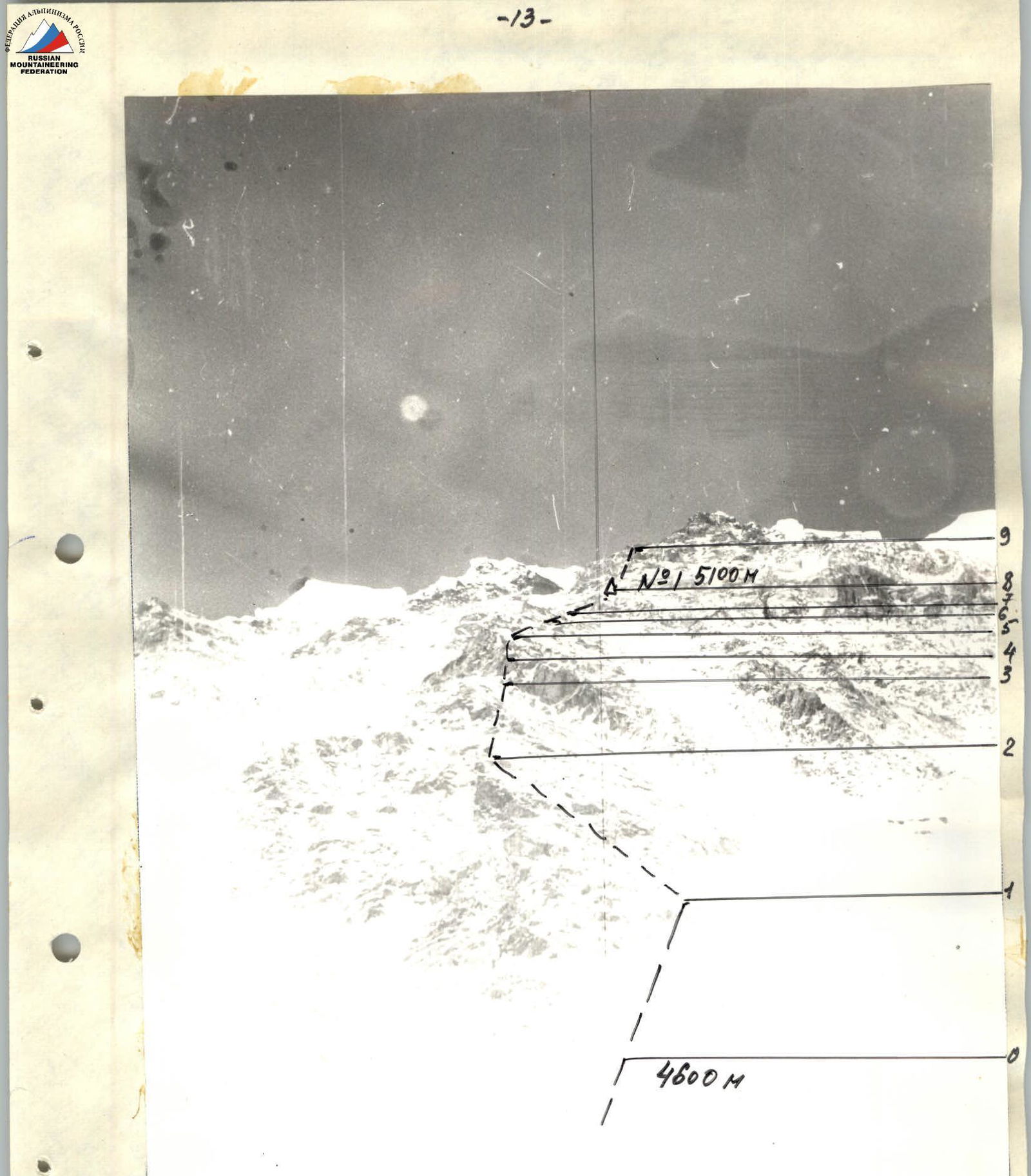
Photo 4. Section D-8. Photo taken from the Walter Glacier. August 6, 1990.
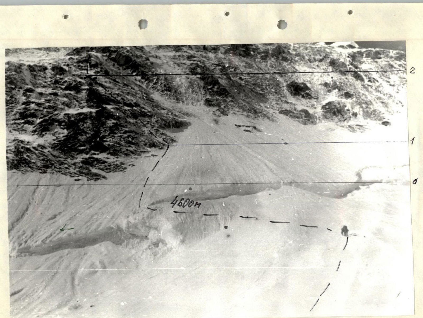
Photo 5. Sections R0–R2, August 4, 1990.