Passport
4.1.57 Peak Kommunizma from the northern ridge with ascent to BPP via the northern spur of Peak Kirova (up to BPP, then Peak Kirova 6372 m) V. Bezzubkin, 71, 6A cat.
- Class: High-altitude technical
- Pamir. Peter the First Ridge.
- Peak Kirova (6372 m) via the northern ridge with ascent to BPP via the northern spur of Peak Kirova.
- Proposed - 6A cat., combination.
- Route type: Combined.
- Height difference of the main part of the route (up to BPP): ≈1600 m
Length of the main part of the route (up to BPP): ≈2000 m. Average steepness of the main part of the route: 60°. Length of sections with 5th category difficulty: 670 m, 6th category difficulty: 85 m.
- Pitons left on the route: total: 2, including bolted: 0.
Pitons used on the route:
- bolted stationary: 0, including artificial climbing holds (ACH) - 0. Total ACH used: 14.
- Team's climbing hours: 75. Days: 10.
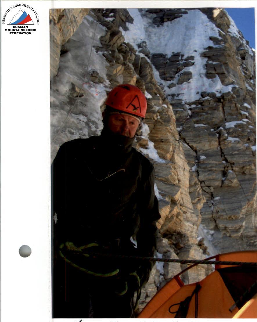
- Team leader: Nagovitsyna E.Yu. (MS).
Team members:
- Lavrinenko V.V. (MS)
- Petrushin V.I. (CMS)
- Samoshin R.A. (1st sports category)
- Coach: Lavrinenko V.V. (MS, 2nd cat.)
Baykovsky Yu.V. (MS, 1st cat.)
- Departure to the route: 5:30, August 14, 2006.
Ascent to the summit: 10:00, August 23, 2006. Return to base camp: 21:00, August 23, 2006.
General photo of the main (wall) part of the route.
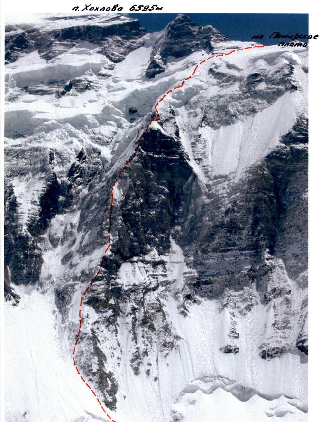
Photo from the internet archive of "ASIA TRAVEL" company. Taken from Peak Vorob'yeva. Photo #1.
Route Profile (Northern Spur)
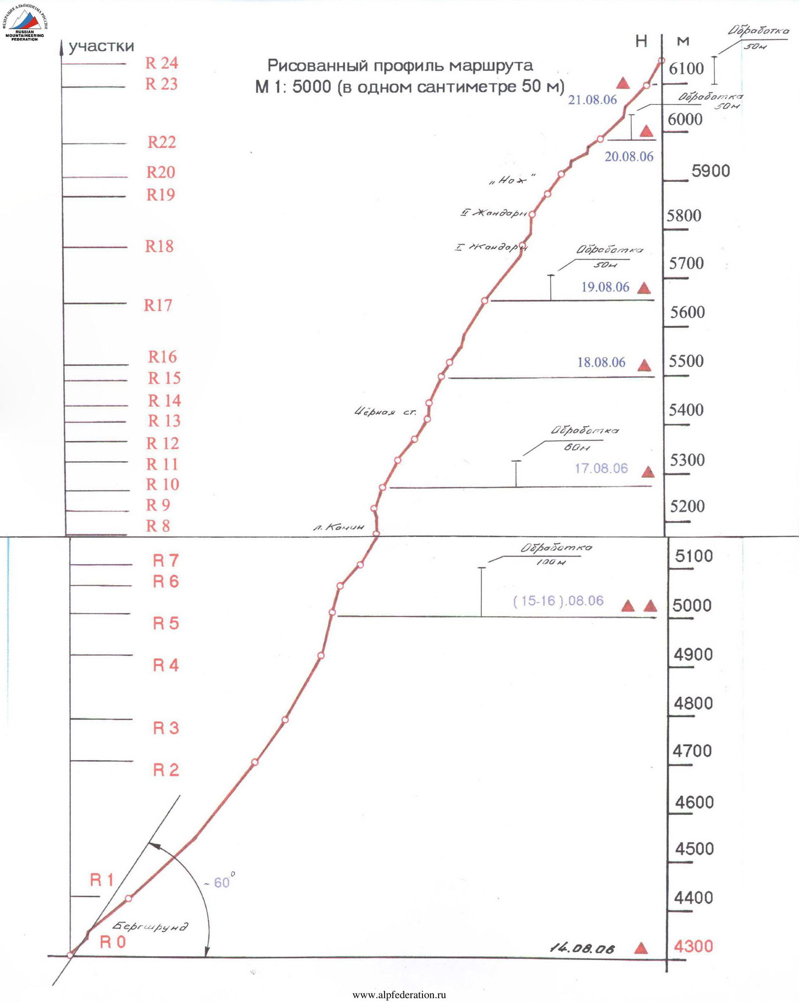 Drawn route profile
This step involved analyzing similar data from other reports to estimate the steepness of the route. Team measurements suggested an average steepness of around 60° from the bergschrund to the traverse towards BPP (around 6100 m), which is considered to be a more accurate representation. The steepness of the eastern ridge of Peak Kirova was measured to be around 35°.
Brief Overview of the Ascent Object
Peak Kirova (6372 m) with its extended eastern ridge is located in the northern part of the Big Pamir Plateau (BPP), bordering it from the north and forming the so-called "Small Barrier" (as defined by E.V. Timashev).
The Pamir Firn Plateau occupies a unique position among the glaciers of this region of Pamir. This distinctive geomorphological formation adjoins the Peter the First Ridge. The area of BPP is 20.9 km². The lowest point is at 4700 m, where the largest ice discharge of the plateau, known as the Trampolinny Glacier, originates. The marginal sections of the plateau on the east and southeast under the slopes of Peak Kommunizma reach an altitude of 6300 m.
The massif of Peak Kommunizma together with its vast shoulder, Peak Dushanbe (6950 m), and peaks:
- Kuibyshev (6189 m);
- "Kroshka" (5854 m);
- Leningrad (6507 m);
- Abalakova (6446 m)
frame the plateau from the south. This part of the Peter the First Ridge was named the "Big Barrier" in 1947 (also by E.V. Timashev).
The plateau was first discovered in 1932 by A.V. Moskvin's team and mapped by the team's topographer, Yu.V. Walter.
The plateau was first seen in its entirety in a photopanorama taken by S. Popov during an alpinism expedition by the "Nauka" sports society in 1939. Good photographs of the plateau were also taken during another expedition, specifically by E. Timashev, during his ascent of Peak 30th Anniversary of the Soviet State.
The first climbers to reach the Pamir Firn Plateau were participants in the "Burevestnik" expedition led by K.K. Kuzmin in 1957. The route passed from the Belyaev Glacier along the ridge of Peak Kuibyshev onto the plateau and then to Peak Kommunizma.
In 1967, a high-altitude parachute jump was made from BPP for the first time. From 1971 until the beginning of "perestroika," BPP was used for medical and biological research by the Academy of Sciences of Tajikistan (led by V. Mashkov). Remnants of this high-altitude laboratory can still be seen at the site of a large army tent.
During the years of the MALP (1974-1993):
- classic routes to Peak Kommunizma passed through BPP (both from the Moskvin branch and from Fortambek);
- many other routes, including those to neighboring "six-thousanders" (such as Peak Kirova), also passed through the plateau.
Currently, only the Moskvin branch is operational in the area. All activities are carried out by the "ASIA TRAVEL" and "ALP MASHKOV" group of companies. Being the "undisputed monopolists" in their sphere of "services," it is with great regret that one notes the loss of the best traditions of Soviet high-altitude alpinism in this region.
Peak Kirova (6372 m) was discovered in 1932. The name was assigned in 1935. Some sources incorrectly state that the peak was first conquered in 1957; however, the first ascent was made by alpinists from Donetsk "Avangard" on August 5, 1970, via the western wall, 5B cat., led by V. Rusanov. In 1972, a route was made via the central counterfort of the western wall, 5B cat., led by M. Konkov. There are several other routes to this peak:
- Via the northern ridge (during a traverse to Peak Kommunizma in 1973, led by G. Kaspirovich, 5B cat.);
- Via the northern slope (5B cat., by F. Thornhill in 1992);
- Via the eastern ridge from the Valktera Glacier, passed by V. Alfyorov's team in 1980;
- Through BPP - with ascent to it via the "Burevestnik" edge from the Fortambek Glacier.
Our team's ascent of Peak Kirova from BPP is considered the final stage of the overall route, the main part of which ran along the steep and extended northern spur from the Valktera Glacier (Bezzubkin - Dobrovolsky route). The route to Peak Kommunizma via this spur (further, in the upper part, via Peak Khokhlova (6595 m) or Peak Dushanbe (6950 m)) is rightly rated 6A cat. In the unofficial rating, only routes on the southern (southwestern) exposure, along the wall, from the Belyaev Glacier, rank higher, which is confirmed by publications from leading former "high-altitude climbers." The last passage of the spur was dated 13 years prior (in 1994) by a team from Tolyatti.
Currently (and previously), Peak Kirova is rarely visited. The sporting interest lies in other peaks of BPP, including Peak Kommunizma; however, the fact remains that Peak Kirova is the only peak located on the northern edge of BPP, and it is unlikely that anyone has climbed it via this variant (through the Northern Spur of Bezzubkin).
It is now possible to reach the Moskvin clearing mainly by MI-8MT helicopter from either Dushanbe or Jirgital (25-minute flight).
Some features of the area during our ascent are worth noting. There was a low snow cover, resulting in:
- increased risk of rockfall;
- hanging glacier collapses, leading to increased avalanche danger (practically at any time of day);
- many approaches to routes were complicated by ice crevasses and bergschrunds (glaciers were exposed);
- the characteristic relief of many route "threads" changed significantly towards increased difficulty;
- snow slopes turned into ice;
- heavily snowed walls with good "grip" on the rock turned into "live" vertical blocks;
- presence of "snow boards" only added to this list.
The approach to the route from the base camp on the Moskvin clearing passes along the left side of the Valktera Glacier, along the slopes of Peak Vorob'yeva (5691 m). It is advisable to set up a storm camp on the moraine ridge, directly opposite the northern spur. The approach time (with backpacks) takes 1.5-2 hours.
Team Tactical Actions
Initially, in Moscow, the main option for the team's ascent within the framework of the Russian Championship in the high-altitude technical class was planned to be the route to Peak Kommunizma via the northern spur from the Valktera Glacier (Bezzubkin route, 6A cat.).
Reports from previous teams were studied in the FSR archive, and a comparative analysis was conducted. Valuable consultations were provided by:
- Stepanov I.;
- Cherny N.;
- Golovin A.;
- Lavrinenko Vyach. and others.
Directly on site, useful advice was given by P. Chochia and A. Gerasimov. Based on the gathered information, a tactical plan for the ascent was developed:
- approximate time for passing through sections of the route;
- planned locations for overnight stays;
- necessary equipment was selected;
- reserve days were planned.
Fuel and food were taken with a large surplus - for 12 days, in case of potential weather-related delays.
Before the ascent, the team's quantitative composition was determined - 2 teams, 4 people.
The following were clearly agreed upon with the hosting party:
- dates for the team's evacuation from the Moskvin clearing (last helicopter flight - August 27);
- radio communication schedule;
- control time for the ascent (documented with the head of the sports department of the "Alp-Mashkov" camp - Alexander Gerasimov).
Unfortunately, the team was unable to fully implement the ascent plan to Peak Kommunizma.
After completing the main, most labor-intensive part of the route (namely, the Bezzubkin spur), the camp management "ultimately" suggested that we immediately descend to the last helicopter flight on August 24.
Simultaneously, a command was given to:
- completely evacuate all intermediate camps on the Bородkin route;
- remove belay ropes, marking flags, etc.;
- evacuate the base branch.
These hasty actions by the hosting party's management grossly violated the previously reached agreements with the team.
In this difficult situation, the team decided to continue the route and ascend the most nearby, but rarely visited peak on the northern part of BPP - Peak Kirova (6372 m).
Passing through the spur took slightly longer than planned.
In addition to the planned overnight stays, additional ones were organized (not always convenient, but in safe locations). The reason for this was the extremely unusual climatic conditions for this region - hot July and, as a result, increased rockfall danger (more details on this are in the "Brief Overview of the Area and Ascent Object").
Often, when one team member moved, the others below had to stop due to falling rocks, even from a moving rope. The movement was also slowed by:
- a shortened belay rope, broken by a rock on the first day;
- time spent on preparing overnight stay platforms.
As 12 years had passed without ascents, even the two platforms we encountered were completely covered in thick layers of ice and snow.
The team moved with a changing lead; for other participants, belay techniques were used. The lead always worked on two 9mm dynamic ropes with a lightened backpack (sometimes without it) and the necessary modern equipment. Most of the route was covered by the lead in crampons. The most complex rock sections requiring advanced rock climbing techniques were passed "simply in boots," and during "warm" times of the day, rock shoes were sometimes used. Constantly changing footwear on the route required significant skill and mastery from the lead.
The main reason for the not very high speed of advancement was the increased rockfall danger on the wall. Passing through such sections required:
- increased attention;
- careful climbing;
- careful positioning on sections - this was a guarantee of their safety.
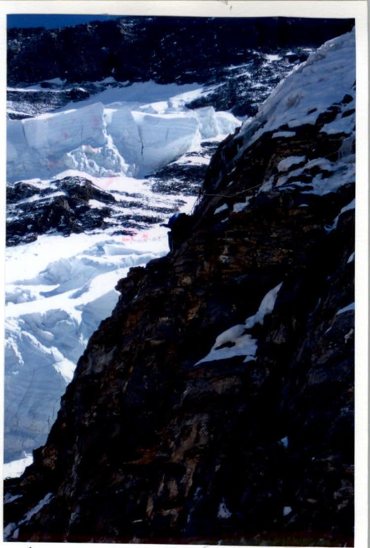
Often, the team had to wait to avoid getting caught in the next rockfall. Objectively dangerous places were passed quickly. Overall, the route is generally safe. The likelihood of spontaneous rock and ice falls is low. The exception is the lower (ice) part of the route (about 12 ropes), which is partially hit by rocks and avalanches (was passed by the team early in the morning).
The lead had all necessary equipment for rock and ice work on the wall. Widely used were:
- placement elements (stoppers, friends, cam hammers);
- pitons (various modifications and anchors).
Among the placements, average sizes worked well; among pitons, anchors and boxes performed best. Domestic titanium ice screws proved effective on icy relief, while shortened "Black Diamond" ice screws worked well on "nattekh" (a type of ice formation). "Ice-fifi" hooks (for both ice and rock) were invaluable during the wall passage.
In the upper part of the spur (during the traverse towards BPP along a steep, extremely unreliable snowy slope), only anchor rock pitons were used on rare rock outcrops.
Belay points were made:
- in safe locations;
- on at least 3 points.
Old loops and ropes were not used. Rarely encountered pitons were checked. Where possible, complex sections were passed using free climbing; where not, artificial climbing holds (ACH) were used.
The team's movement pace allowed them not to stop specifically for rest during the working day. Each member had a pocket snack and drink. This pace allowed the entire team to maintain good working capacity throughout the ascent. The team had:
- physical reserve;
- technical reserve.
As mentioned above, the team had to organize several unplanned overnight stays. Usually, the second team started preparing for this during daylight hours, while the first team continued working. Good locations on the route are scarce (except for the upper part). Old platforms have changed significantly (some have severely damaged artificial masonry). Sometimes, such an operation (platform preparation) took several hours.
Our tent design allowed it to be set up on relatively small areas while maintaining the necessary internal volume. Safety during overnight stays was given special attention.
Serious injuries were avoided. It is impossible to anticipate all nuances and problems of the ascent. However, the team coped with the main tasks of the route's key sections. A friendly working atmosphere was maintained within the team. Emerging problems were resolved quickly and efficiently, with all safety measures observed.
Some relatively new (or well-forgotten old) gear samples are worth noting:
- rock anchor pitons;
- lightweight quickdraws and loops;
- ice screws with improved surface treatment;
- modern gas burners and windshields;
- "Ti-block";
- shock-absorbing self-belay devices;
- much more.
During bad weather, the team tried to maintain their working pace. Radio communication with the base and observers was maintained regularly every 3 hours; the radio worked clearly, and the power supply "did not drain."
All trash was "utilized" on site; empty gas cylinders were brought down.
The team had a well-equipped first-aid kit with a wide range of medications. In case of emergency rescue operations on the spur, the team would have had to rely solely on their own strength. Near Peak Kirova, assistance could have been provided by the "ALP-MASHKOV" rescue team. Using a helicopter would have required additional significant resources.
Route diagram in UIAA symbols.
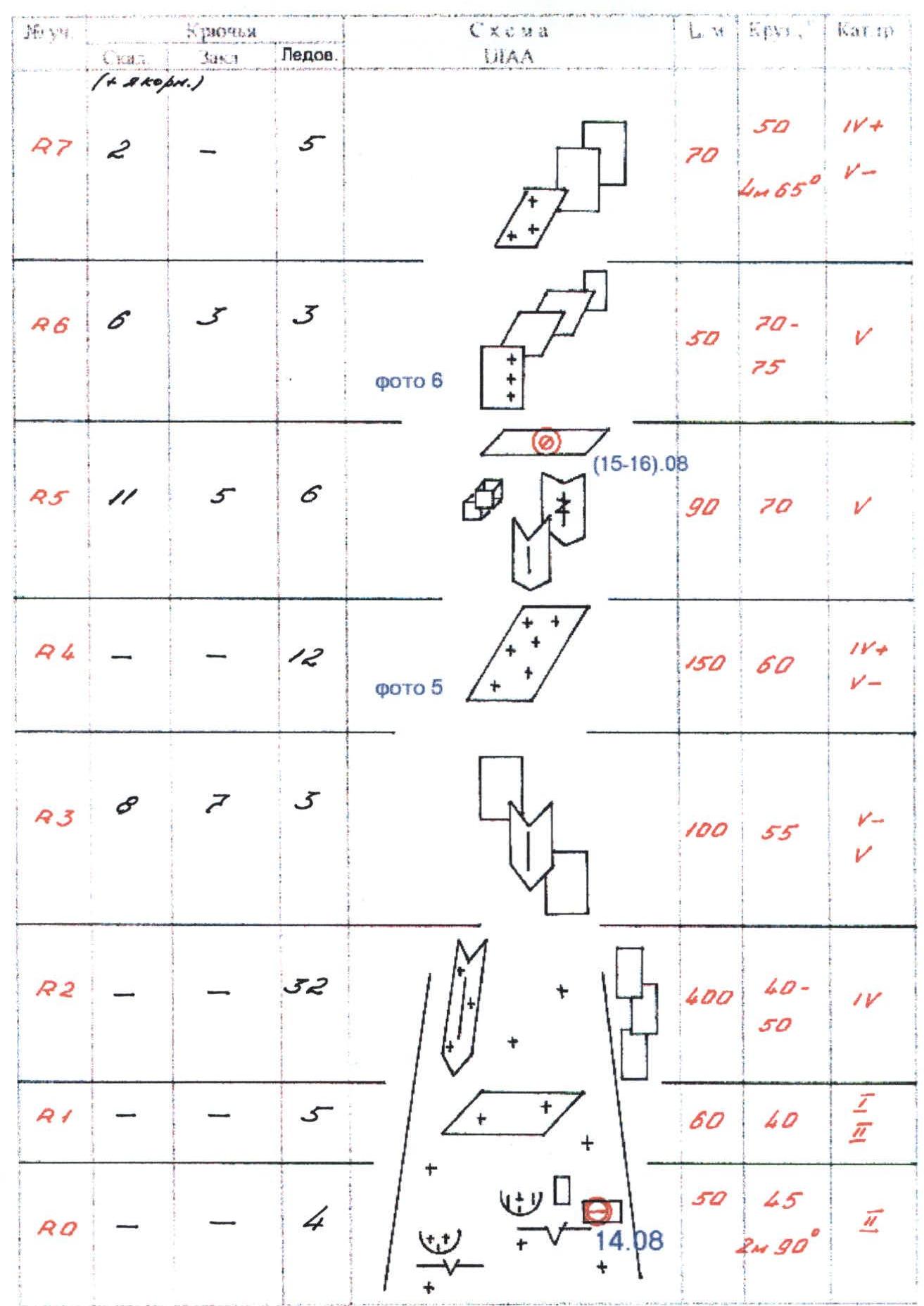
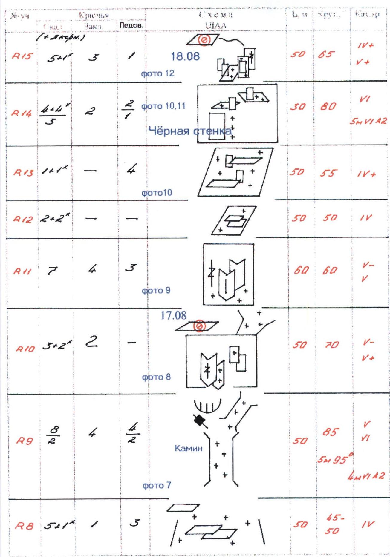

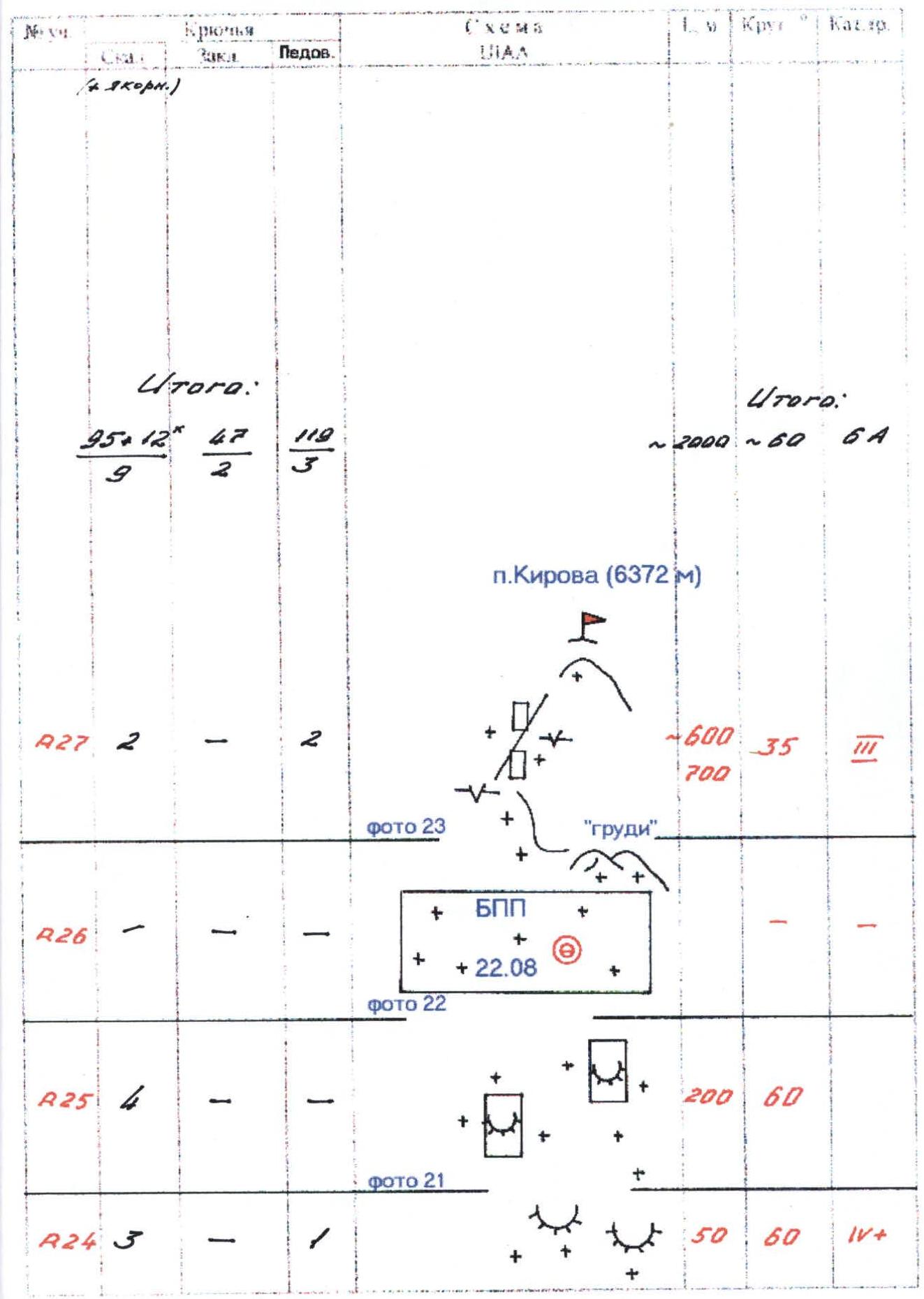 Route diagram in UIAA symbols
Technical photo of the main (wall) part of the route.
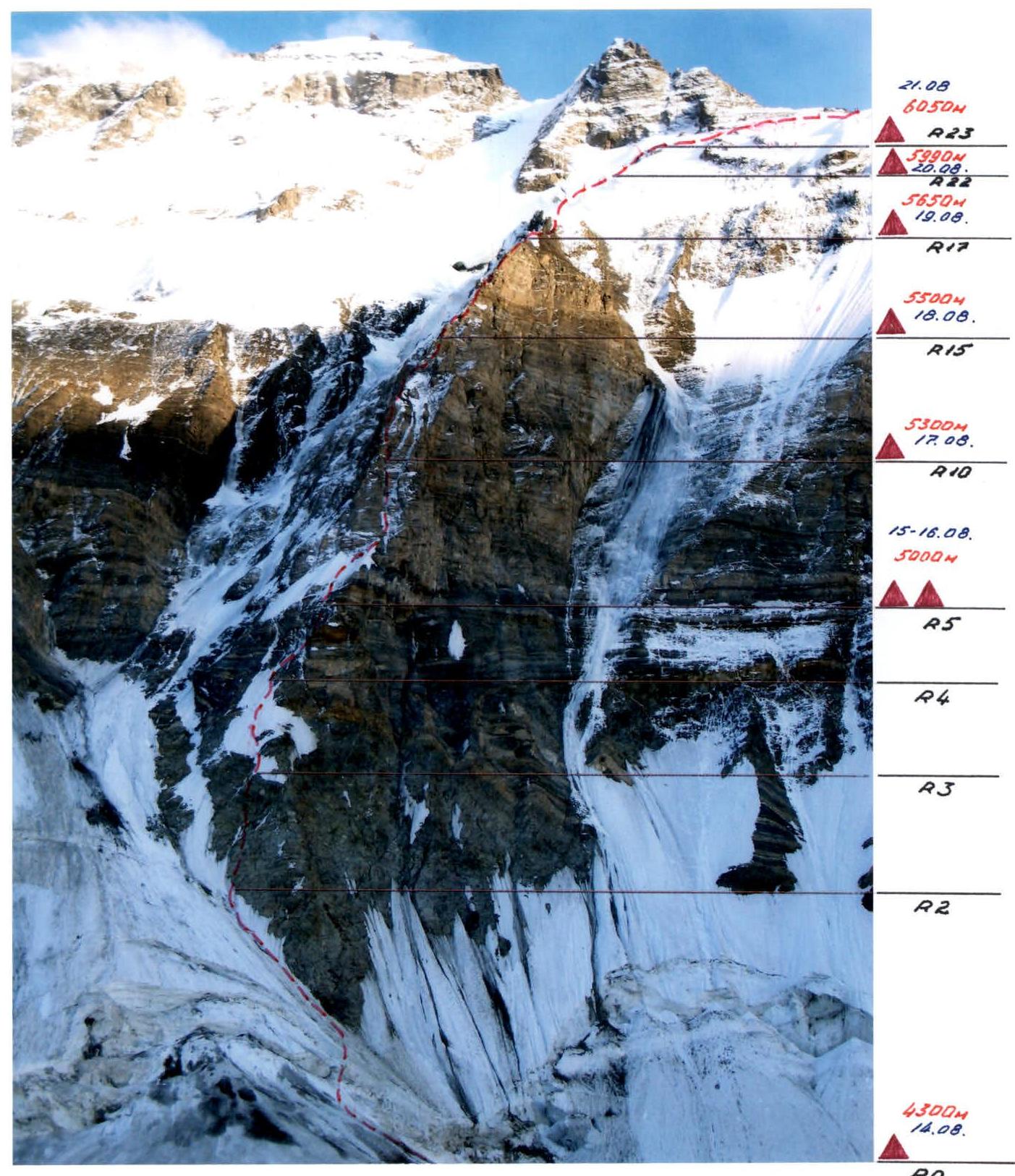 Taken from the moraine of the Valktera Glacier. Height - 4500 m, distance - 1.5 km. Photo #4 (route diagram in UIAA symbols).
Brief Description of the Route by Sections
R0
Heavily crevassed glacier:
- open crevasses;
- unreliable bridges;
- large bergschrund with a steep wall.
R1
Relatively gentle ice slope.
R2
Quite an extended section, the lower part of a wide ice couloir (to the left of the main northern spur). Movement along the lower "claw" of the wall.
- To the left, characteristic narrow ice gutters from falling rocks;
- belay on ice screws.
R3
Ascent onto ice-covered and snow-covered rocks. The rock is heavily destroyed, with many live rocks. Movement along a vaguely expressed internal angle.
R4 (photo 5)
Characteristic snow-ice patch. Steepness is greater than expected from below. Ice is hard.
Photo 5. R4.
R5
Heavily destroyed rocks, live blocks. System of internal angles and cracks. Very careful climbing, difficult to organize belay. At the end of the section, an overnight stay is organized on a restored narrow platform.
R6 (photo 6)
Inclined ice-covered slabs with a "tiled" structure. Gradual increase in steepness. Rocks are snow-covered.
Photo 6. R6. Exit from the overnight stay.

R7
At the beginning - an ice slope. At the end of the section - ascent onto rocks. Typical "mixed" climbing.
R8
Wide snow-covered couloir with islands of rocks. Approach to the chimney.
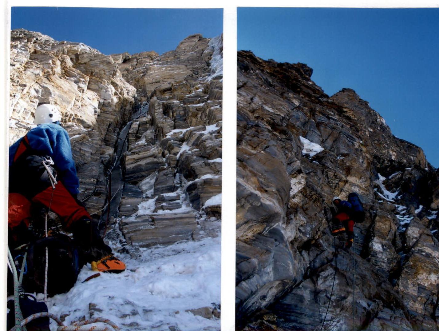
R9 (photo 7)
One of the key sections of the route. Steep chimney filled with ice. Ice is very hard, strongly frozen.
Further:
- through a small overhang;
- along a crack;
- exit left onto rocks.
Climbing is difficult; the belayer needs maximum concentration. Most of the section is passed using free climbing; the upper cornice is on ACH.
Photo 7. R9. Chimney.
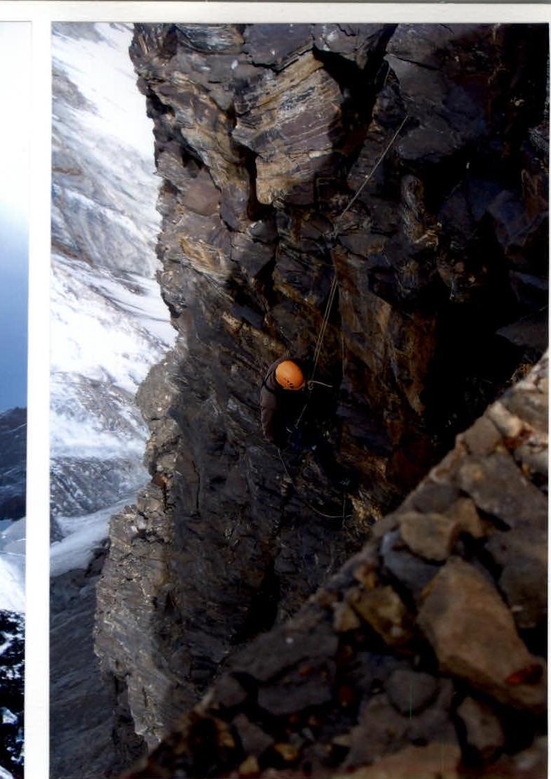
R10 (photo 8)
Heavily dissected, quite steep wall. System of cracks and internal angles. Many live rocks. Exit to an overnight stay. The upper part of the ice chimney remains to the right.
Photo 8. R10.
R11 (photo 9)
Steep snow-covered rocks, ice in the lower part. "Mixed" climbing. Belay - combined.
Photo 9. Beginning of R11.
R12
Destroyed slab-like rocks. Slightly easier than the previous section. Climbing is careful. In photos from previous years, this section was completely covered in snow.
R13 (photo 10)
Ice slope with islands of rocks.
R14 (photo 10, 11)
Beginning of another rock bastion. In the lower part - a steep black wall (passed "head-on," partially on ACH). Climbing is difficult.
Photo 10. R13-R14. Approach to the Black Wall.

Photo 11. R14. Work on belays.
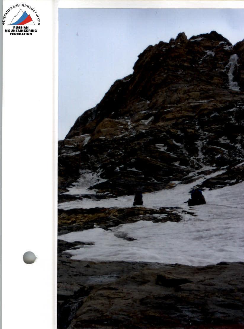
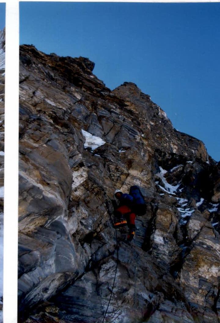
R15 (photo 12)
Ice-covered steep slabs. Exit onto a ridge under a sheer tower. Platform preparation, overnight stay.
Photo 12. Middle of R15.
Photo 12a. R15. Overnight stay.
R16
Traverse right into a chimney leading to the top of the tower. Further - heavily destroyed rock ridge. The rock is very fragile, difficult to organize belay.
R17 (photo 13, 14)
Exit from the firn shoulder. Steep rock wall with ice formations. Further - a slight flattening along the destroyed ridge and exit onto an ice slope. In the upper part of the ice, on the border with rocks - platform preparation and overnight stay.
Photo 13. R17. After the firn shoulder.

Photo 14. R17. Gendarmes.
R18 (photo 15, 16)
First "gendarmes." Before it - a short firn shoulder. Bypass of the "gendarmes" from the right upwards with exit onto a ledge. Marble-like slabs. Ascent onto the "gendarmes" "head-on." In the upper part - a short sheer wall. Difficult climbing. The section is passed using free climbing, without ACH.
Photo 15. R18. I Gendarmes. General view.
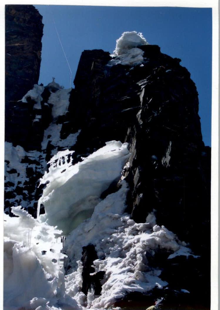
Photo 16. R18. Upper part of I Gendarmes.
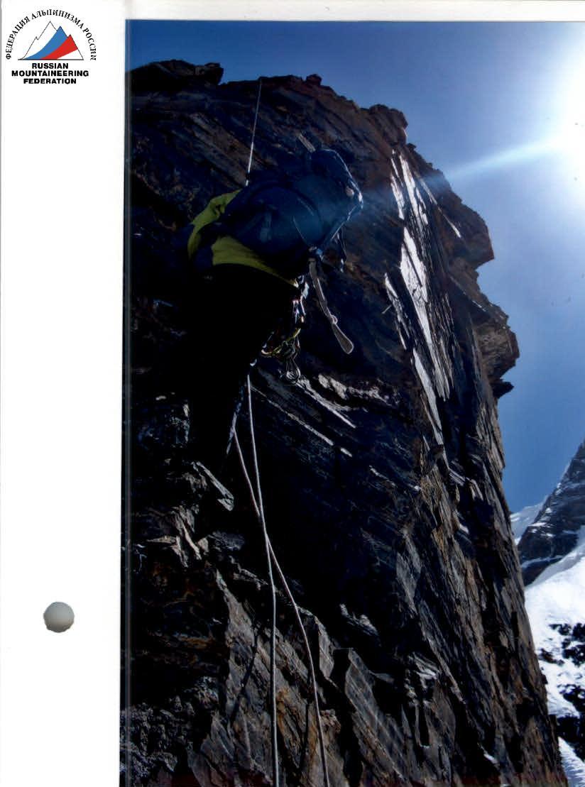
R19 (photo 17, 18)
Traverse along narrow ledges to the base of the 2nd "gendarmes." Very steep (practically sheer) large-block wall (most of it is passed using free climbing, partially on ACH).
Further:
- relatively gentle destroyed ridge;
- "airy" snow-ice overhangs.
Approach to the main ice-firn ridge ("knife edge").
Photo 17. R19. II Gendarmes.
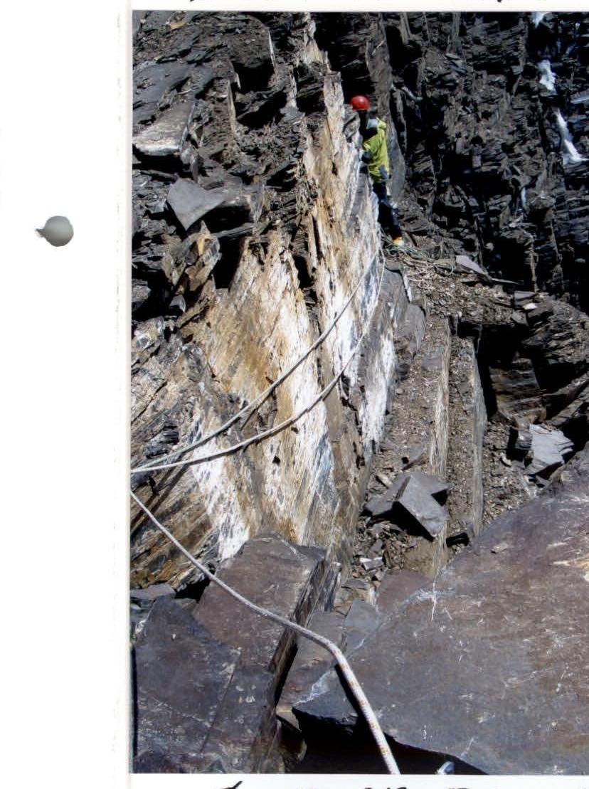
Photo 18. R19.
R20 (photo 19)
Sharp ice-firn ridge leading to wide snow slopes.
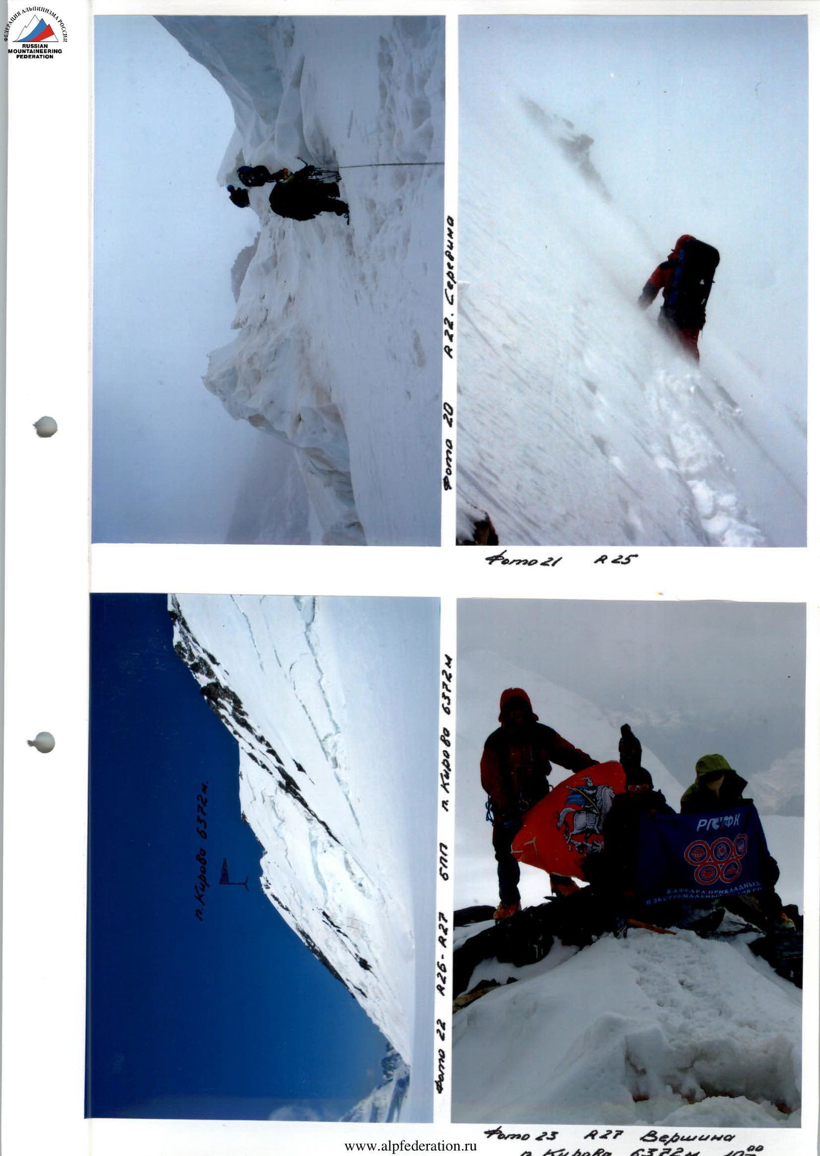
R21-R22 (photo 19, 20)
Quite an extended section. Wide snow slope. Steepness is deceptive. Slopes are heavily loaded, posing an objective danger. Careful movement. Belay on ice screws behind ice seracs. There are:
- closed crevasses;
- small but steep wall sections. Under one of the seracs, another overnight stay was organized (the most convenient on the entire route).
Photo 19. R20. "Knife edge." R21-R22.
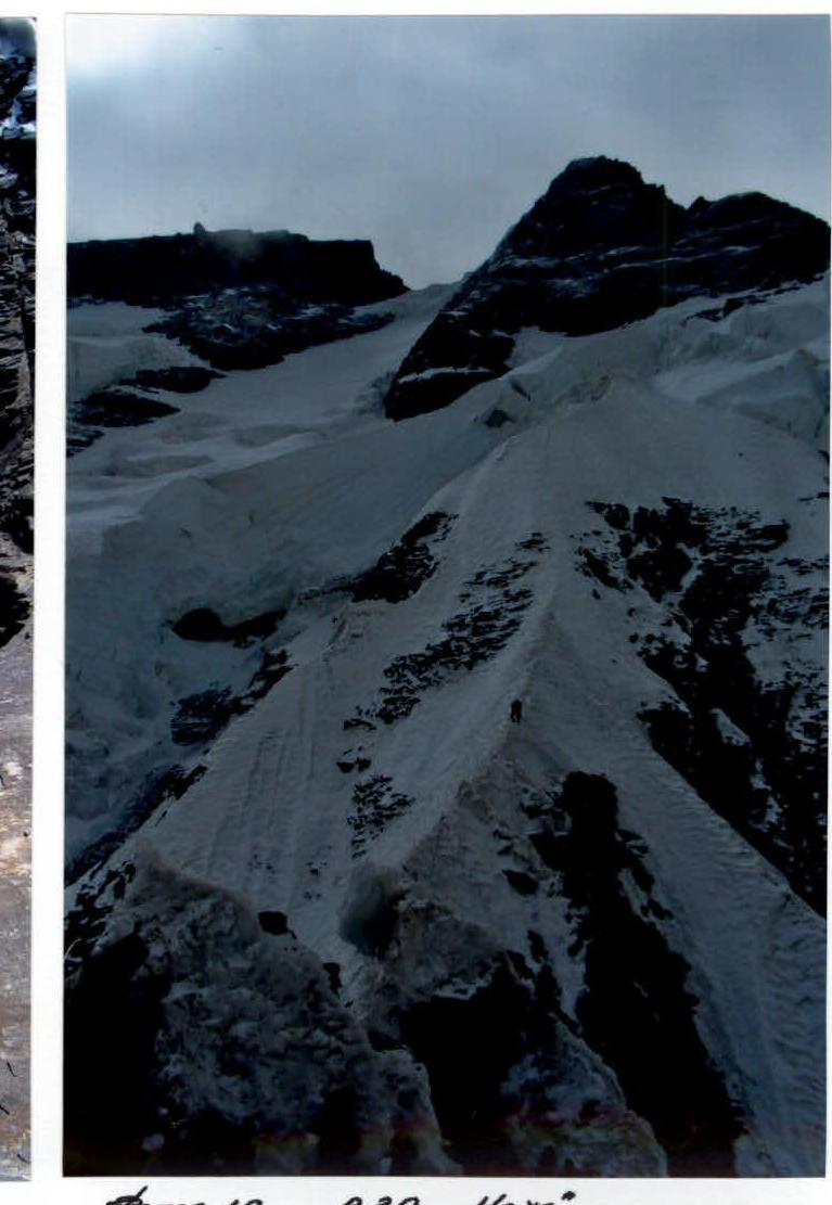
Photo 20. R22. Middle.
R23
Scree snow slope, snow is deep. Avalanche danger. Crevasses are encountered. Near the "closed" bergschrund - overnight stay.
R24
From the previous overnight stay upwards through a crevasse along a snow bridge under the rocks of the "Big Triangle." This is considered the highest point of the spur, from where the traverse to the right towards BPP begins. In the distance, the shoulder of Peak Kirova ("breasts") is clearly visible.
R25 (photo 21)
Prolonged traverse along a steep avalanche-prone slope to the right. Very difficult to organize belay. Stations - on rare "ram's foreheads" on anchor pitons.
Extremely careful climbing. In the gaps of the fog, BPP is visible below. Further, to the left downwards, to the beginning of the plateau, under the slopes of Peak Khokhlova.
R26
Pamir Firn Plateau, sometimes with rare crevasses. Overnight stay.
The next day:
- approach to the slopes of Peak Kirova;
- selection of the optimal ascent path.
R27 (photo 22, 23)
Not very steep snow slope, turning into a wide ridge in the upper part. Summit. Descent onto BPP along the ascent path and further through the "breasts" along the Borodkin ridge to the base camp.