Kiev City Council of Sports Societies and Organizations
Report
On the ascent of Peak Communism via the north-eastern ridge from Stalin Glacier
Kiev, 1967
| № | Full Name | Sports rank | Year of birth | Party affiliation | Member since | Profession | Address |
|---|---|---|---|---|---|---|---|
| 1. | KUSTOVSKY Anatoly Alekseevich (leader) | Master of Sports | 1925 | non-party | 1949 | Engineer | Kiev, B. Druzhby Narodov 28-a, apt. 14 |
| 2. | CHEREVKO Vladimir Leonidovich | Candidate Master | 1934 | CPSU member | 1953 | Engineer | Kiev, Elektrotekhnichesky per. 10, apt. 50 |
| 3. | KOLESNIK Vasily Vasilyevich | 1st sports category | 1939 | Komsomol member | 1956 | Engineer | Kiev, Pushkinskaya 34, apt. 40 |
| 4. | ZAYD Pavel Wolfovich | 1st sports category | 1937 | non-party | 1956 | Geologist | Osh, Shakhterskaya 51, apt. 6 |
II. Organizational Plan of the Ascent
The organizational plan for the ascent included a whole range of activities:
- Gathering all participants in Osh and starting the expedition on July 15.
- Organizing and relocating the expedition, setting up a base camp on the glacier by the lake at an altitude of 3900 m (Bivachny) on July 24.
- Acclimatization and reconnaissance sorties, training ascents, organization of preventive and rescue measures, ascent, evacuation, and the end of the expedition on August 25.
Unfortunately, numerous complications arose in Osh. Some members of the main team were unable to participate in the expedition for various reasons. The expedition cargo got stuck on the railway in Tashkent, and it had to be transported by car. Despite this, we barely deviated from the planned schedule. By July 18, 1953, the caravan with the advance team had already left Daroot-Kurgan.
But the main difficulties were yet to come. All attempts by the caravan to cross the swollen rivers ended in failure. There was a threat of the entire expedition being disrupted. Only the help of helicopters from the Army sports club team helped us establish a base camp on Fedchenko Glacier on July 29 - significantly lower than the planned location. As a result of all these troubles, we had to:
- revise our plans;
- develop a very clear schedule for the further work of the expedition.
First of all, it was necessary to organize an upper base camp by the lake at an altitude of 3900 m. This work was completed by August 3. We then conducted a reconnaissance of the route, reaching heights of 4600–4800 m via Stalin Glacier.
As an acclimatization and training ascent, a climb to Peak Pravdy was chosen (part of the group), with a review and reconnaissance of the route from the ridge of Peak Radioklub (the second part of the group).
The ascent to the ridge and plateau, apart from reconnaissance, allowed us to:
- examine the descent onto the plateau;
- leave a sufficient reserve of supplies and medicines in a cave on the plateau.
Preventive and rescue measures were ensured by the expedition team. To ensure the safety of the ascent, it was deemed целесообразным:
- for the second team to ascend Peak Communism via the descent route of the main group (Tamms path) in parallel.
Both groups were connected to each other and to the base camp via "Nedra" type radio stations.
The expedition doctor was located at the upper base camp (3900 m).
III. Tactical Plan of the Ascent
The tactical plan for the ascent, drawn up before leaving for the mountains, was adjusted based on observations and reconnaissance.
The north-eastern ridge of "Communism" drops to Stalin Glacier with a wide triangular snow-ice wall, flanked by rocky ridges on the left and right and with separate rocky outcrops in the center. The entire wall is dominated by huge firn fields, ending in a wide mulde of a hanging glacier on the upper plateau. The firn basin and mulde are the source of constant large-scale avalanches that feed Stalin Glacier.
The reconnaissance results once again confirmed that the path along the right ridge is practically impossible. Although the route is technically passable, the objective danger of ice avalanches from the upper plateau makes it insurmountable for ascent.
The exit to the north-eastern ridge via the left ridge looks even less realistic, although we initially had high hopes for it. The icefall hanging over the upper part of the ridge makes it impassable. During the reconnaissance and ascent, we witnessed several collapses and avalanches that blocked the ridge. Such disappointing results of reconnaissance and observations initially made us doubt the possibility of forging a new path to Peak Communism from Stalin Glacier. Only after this did we notice the possibility of exiting the ridge via the central outcrops. Careful consideration of the route during observation finally convinced us that this is the only relatively safe option. Thus, the following tactical plan for the ascent emerged:
- Exit to the NE ridge of Peak Communism from Stalin Glacier via rocky outcrops.
- Due to the impossibility of ensuring cargo delivery and route preparation along the ascent path, preparation would be done via the plateau.
- Simultaneously with the main team, a second group should ascend Peak Communism via the plateau. In any case, the second group should remain on the plateau until the main group descends.
- The ascent should take 8–10 days.
IV. Description of the Ascent
August 12. The route begins directly from the Glacier Camp - the main base for the first ascenders of Peak Communism. The starting height of the route is 4600 m. We easily cross the glacier, avoiding seracs, and reach the beginning of the snow-ice slope leading to the "pillow". The average steepness of the slope is about 30°, with sections up to 50°. We proceed wearing crampons, crossing numerous crevices. The height is 5000 m. Traces of avalanches are visible, but they are old, apparently from spring. The general direction of ascent to the "pillow" is along the right (orographic) side of the slope. At 15:00, we reach the "pillow". We cross fresh avalanche deposits and, without delay, move under the cover of the wall to the bergschrund. The passage of this section (R0–R1) took about 5 hours. The bergschrund is heavily broken throughout and lacks a crossing. We set up a tent, and a pair goes to process the bergschrund. They have to descend into the bergschrund and cut a deep trench. In 4 hours, the pair crosses the bergschrund and hangs a rope.
August 13. At 8:00, the first pair departs, crosses the bergschrund, and moves towards the base of the wall of the first rocky outcrop. The steepness is about 60°; we proceed wearing crampons with piton belay, cutting steps (R1–R2). At 11:00, we drive an ice piton into the rocks. Further, we move along the edge of rocks and snow, bypassing rocks on the left, with a steepness of about 70°, cutting steps, and belaying via rock pitons. We cover about 100 m. Further movement along the edge is not possible. Small avalanches periodically fly out from behind the turn (R2–R3). We hang our backpacks and begin the ascent up the wall. The rocks, contrary to our expectations, are solid; even blade pitons are used; progress is slow. In several places, the first climber hangs and leaves ladders. Still, most of the section is traversed with free climbing. We move towards a ledge that goes left to the edge of rocks and ice. The passage of this section (120 m) with the hauling of backpacks took about 5 hours. From the ledge upwards leads a small overhang (8–10 m), which we pass on a ledge. Further, the steepness decreases somewhat to about 70°. By the end of the day, the first climber covers about 40 m and descends to the ledge. We organize an overnight stay on the ledge, sitting along a taut rope (R3–R4).
August 14. After an uncomfortable night, we depart only at 9:00. We cover the processed section in 2 hours and continue moving through the center of the rocky outcrop; climbing is complex, the first climber goes without a backpack. By 14:00, we reach the top of the outcrop (R4–R5). Further, the path goes along a slope with a steepness of about 60° towards the rocks of the second outcrop. We proceed wearing crampons, cutting steps. Small avalanches pass about 50 m to our left. We strive to move as quickly as possible under the reliable cover of the wall of the second outcrop (R5–R6). The lower part of the second outcrop is traversed along the edge of ice and rocks until a turn that shields us from avalanches. The steepness is about 70°; we cut steps, belay via rock pitons. 50 m from the turn, we reach the rocks via an internal corner that turns into a chimney. Again, we organize the hauling of backpacks. By 18:00, we reach a small balcony (R6–R7) and organize an overnight stay here (R6–R7).
August 15. We depart at 7:00. Today, we need to traverse the gap between the second and third rocky outcrops. This is the most dangerous section of the route, and we hurry. From the overnight stay upwards are rocks of medium difficulty, and by 10:00, we are already at the top of the second outcrop (R7–R8). The slope is icy, with a steepness of about 60°. Attempting to walk on front points of crampons is unsuccessful, and we furiously cut steps. Finally, by 14:00, we are under the rocks (R8–R9). Avalanches start to rumble from the left, but they are no longer dangerous. After a tense section, we take a one-hour rest. We continue moving through the rocks of the third outcrop. The rocks are of medium difficulty, with complex sections in places. The average steepness is about 60°. By 18:00, we reach approximately the middle of the outcrop (R9–R10). Here, we manage to create a decent platform and set up a tent.
August 16. We depart at 9:00. We continue moving through the rocks. The nature of the rocks and steepness are roughly the same as yesterday. Only one short section, about 10 m, is traversed without backpacks. By 14:00, we reach the top of the third outcrop under the walls of the ridge supporting the icefall (R10–R11). It is not possible to bypass these walls on the left via the icefall, and we are forced to climb the wall. The entire wall section, about 60 m, is traversed on ledges, using, in addition to regular pitons, 4 bolt pitons. The passage is significantly hindered by ice accretion and large icicles hanging in clusters. This is, perhaps, the most complex section of the route. The height is 6300–6400 m. We have never had to use ledges and bolt pitons at such an altitude before. Finally, around 18:00, we are on the ridge. We descend from the ridge and cut out an excellent platform for the night in the snow slope.
August 17. We depart at 10:00. The path goes along a snow slope to the left of the ridge. The snow is dense; crampons hold well, with an average steepness of 30–40°. Although the path does not present technical difficulties, we move slowly. The altitude is taking its toll, and the wall has exhausted us; besides, we have packed all the "hardware" into our backpacks. By 10:00, we cross the left steep ridge. From here, there is a good view of the summit ridge and plateau. The weather worsens - wind, snow. We cut out a platform and struggle to set up a tent. As soon as we remove our down mittens, our hands immediately freeze. The wind tears at the tent. Only towards morning does it subside a bit.
August 18. We depart at 11:00. The path goes along the ridge via a snow slope towards the saddle at 7100 m. The average steepness is about 40°. By evening, the wind picks up again, and at 17:00, we stop for the night, having covered about half the distance to the saddle.
August 19. The wind does not subside throughout the night and the entire day. An attempt to depart around 11:00 ends with a hasty retreat back to the tent. The wind and snow are literally scorching our faces. We spend the entire day in the tent.
August 20. The wind has decreased somewhat. Covering our faces with makeshift masks, we continue moving towards the saddle. Below, on the plateau, we see our auxiliary group on the slopes of Peak Pravdy. By 17:00, we reach the saddle at 7100 m.
August 21. We depart at 10:00. The path along the ridge to the summit takes about 4 hours, and at 14:00, we are on the summit. The wind is hurricane-force, knocking us off our feet. Our masks also offer little protection. We hastily write a note and begin our descent. By 16:00, we are at the tent.
August 22. We begin our descent to the plateau. Despite being familiar with the descent path, we move very slowly. The tension of the previous days is taking its toll. Only at 23:00 do we reach our assistants in the cave on the slopes of Peak Russia.
August 23. We descend the entire group to 5100 m.
August 24. We return to the upper base camp by the lake.
Table of Main Characteristics of the Ascent Route to Peak Communism via the North-Eastern Ridge from Stalin Glacier
- Height difference of the route: 2900 m
- Including complex sections: 1300 m
- Steepness of the route: 70°
- Including complex sections: 70°
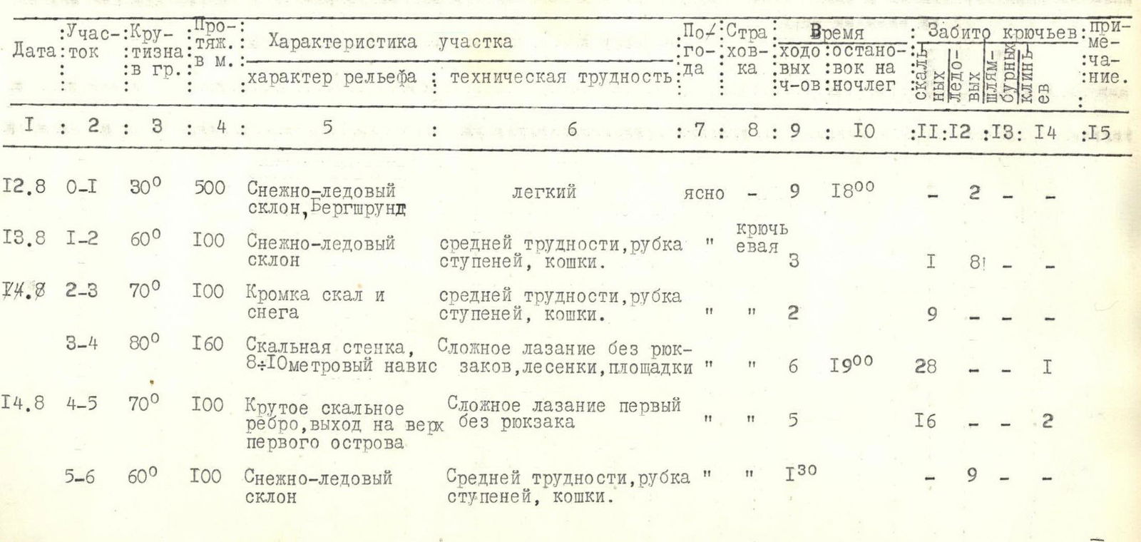
| Date | Section | Steepness in degrees | Length in m | Characteristics of the section | Technical difficulty | Weather | Time, walking hours | Overnight stops | Rock pitons | Ice pitons | Bolt pitons | Climbing irons | Note |
|---|---|---|---|---|---|---|---|---|---|---|---|---|---|
| 12.08 | R0–R1 | 30° | 500 | Snow-ice slope, Bergschrund | Easy | Clear | 9 | 18:00 | 2 | — | — | ||
| 13.08 | R1–R2 | 60° | 100 | Snow-ice slope | Medium difficulty, step cutting, crampons | Piton belay | 3 | 1 | 8 | 1 | — | — | |
| 13.08 | R2–R3 | 70° | 100 | Edge of rocks and snow | Medium difficulty, step cutting, crampons | 2 | 9 | — | — | — | |||
| 13.08 | R3–R4 | 80° | 160 | Rock wall, 8–10 m overhang | Complex climbing without backpacks, ladders, ledges | 6 | 19:00 | 28 | — | 1 | |||
| 14.08 | R4–R5 | 70° | 100 | Steep rock ridge, exit to the top of the first outcrop | Complex climbing, first without backpack | 5 | 16 | — | 2 | ||||
| 14.08 | R5–R6 | 60° | 100 | Snow-ice slope | Medium difficulty, step cutting, crampons | 1 | 30 | 9 | — | — | |||
| 14.08 | R6–R7 | 70° | 50 | Edge of rocks and snow. Chimney. | Medium difficulty, step cutting, crampons. Chimney traversed without backpacks. | 2 | 18:00 | 12 | — | ||||
| 15.08 | R7–R8 | 60° | 50 | Rock ridge, exit to the top of the second outcrop. | Medium difficulty | 3 | 8 | — | — | ||||
| 15.08 | R8–R9 | 60° | 150 | Ice slope. | Medium complexity, crampons, step cutting. | 4 | 12 | ||||||
| 15.08 | R9–R10 | 60° | 150 | Rocky slope, short walls. | Medium difficulty | 3 | 18:00 | 14 | — | — | |||
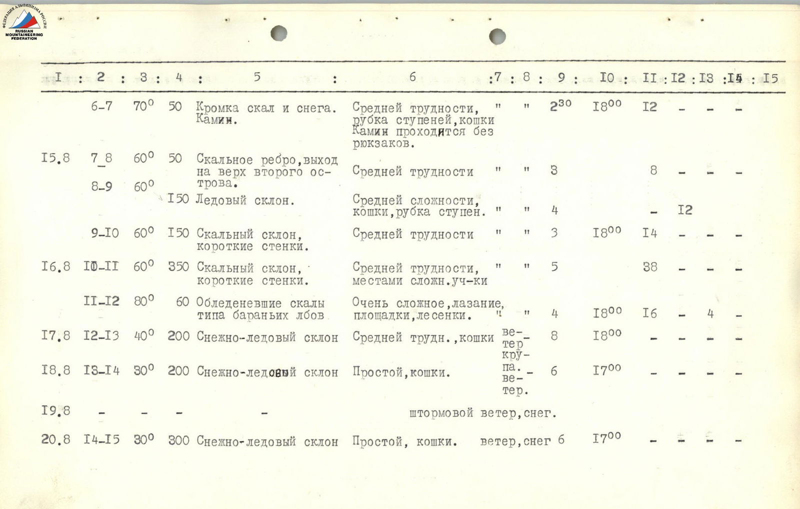
| 16.08 | R10–R11 | 60° | 350 | Rocky slope, short walls. | Medium difficulty, complex sections in places | 5 | 38 | — | — | ||||
| 16.08 | R11–R12 | 80° | 60 | Icy rocks like "sheep's foreheads". | Very complex climbing, ledges, ladders. | 4 | 18:00 | 16 | — | 4 | |||
| 17.08 | R12–R13 | 40° | 200 | Snow-ice slope | Medium difficulty, crampons | Wind, graupel | 8 | 18:00 | — | — | — | ||
| 18.08 | R13–R14 | 30° | 200 | Snow-ice slope | Easy, crampons. | Wind, graupel | 6 | 17:00 | — | — | — | ||
| 19.08 | — | — | Stormy wind, snow. | Stormy wind, snow | — | — | — | — | |||||
| 20.08 | R14–R15 | 30° | 300 | Snow-ice slope | Easy, crampons. | Wind, snow | 6 | 17:00 | — | — | — | ||
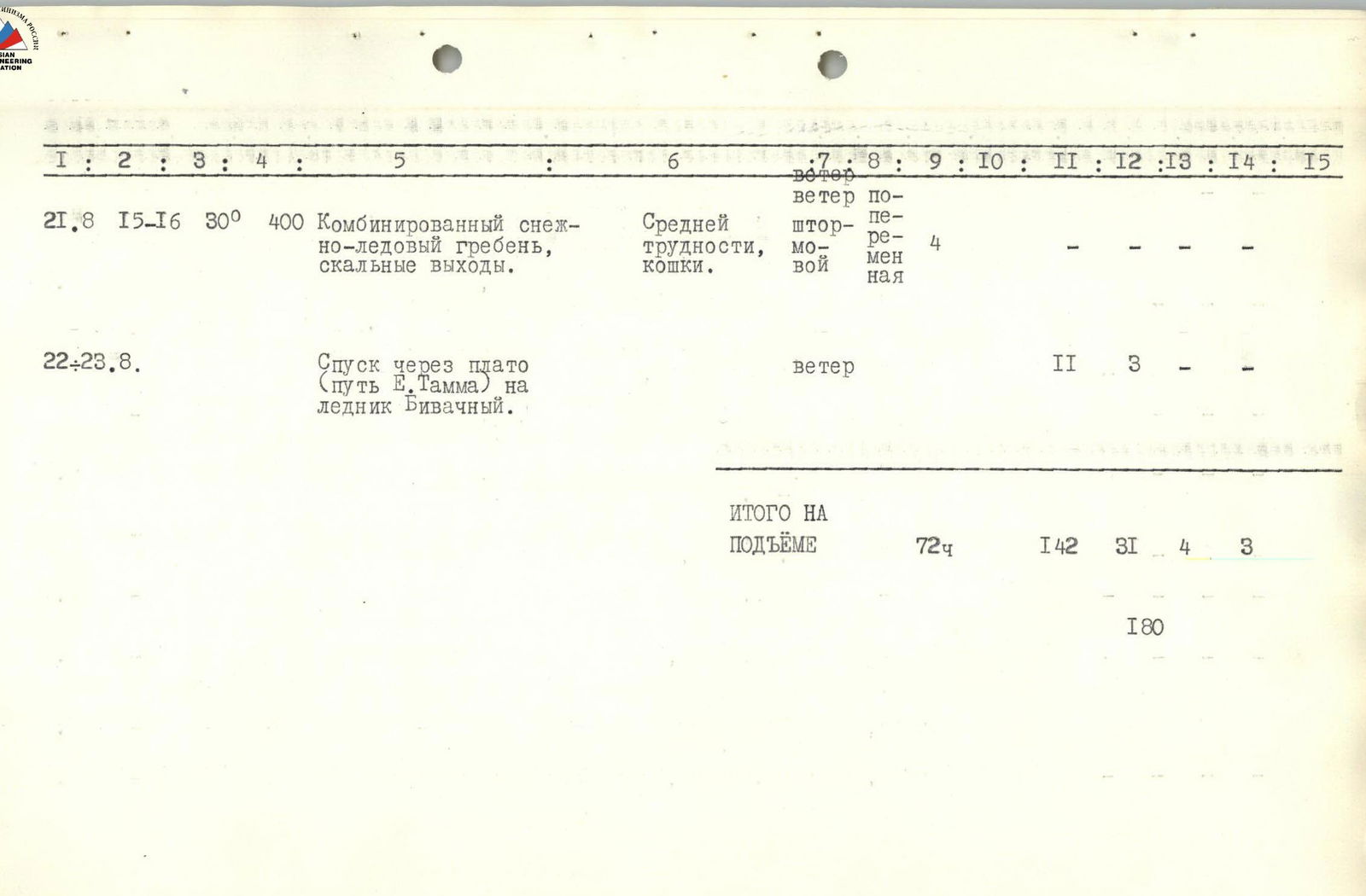
| 21.08 | R15–R16 | 30° | 400 | Combined snow-ice ridge, rock outcrops. | Medium difficulty, stormy, variable | Stormy wind, variable | 4 | ||||||
| 22–23.08 | Descent via the plateau (E. Tamm's path) to Bivachny Glacier. | Wind | 11 | 3 | |||||||||
| TOTAL FOR THE ASCENT | 72 hours | 142 | 31 | 4 | 3 | ||||||||
| 180 |
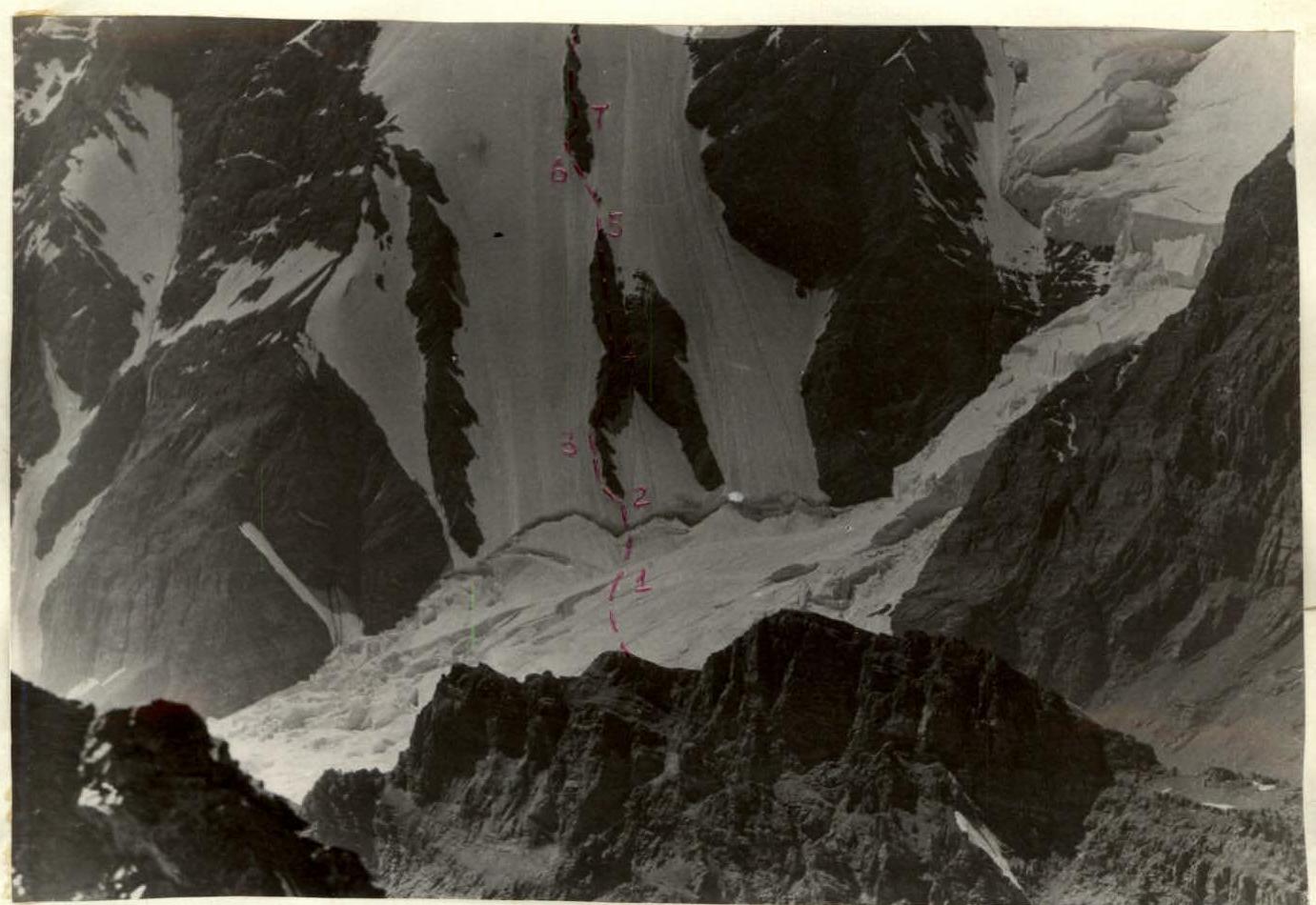
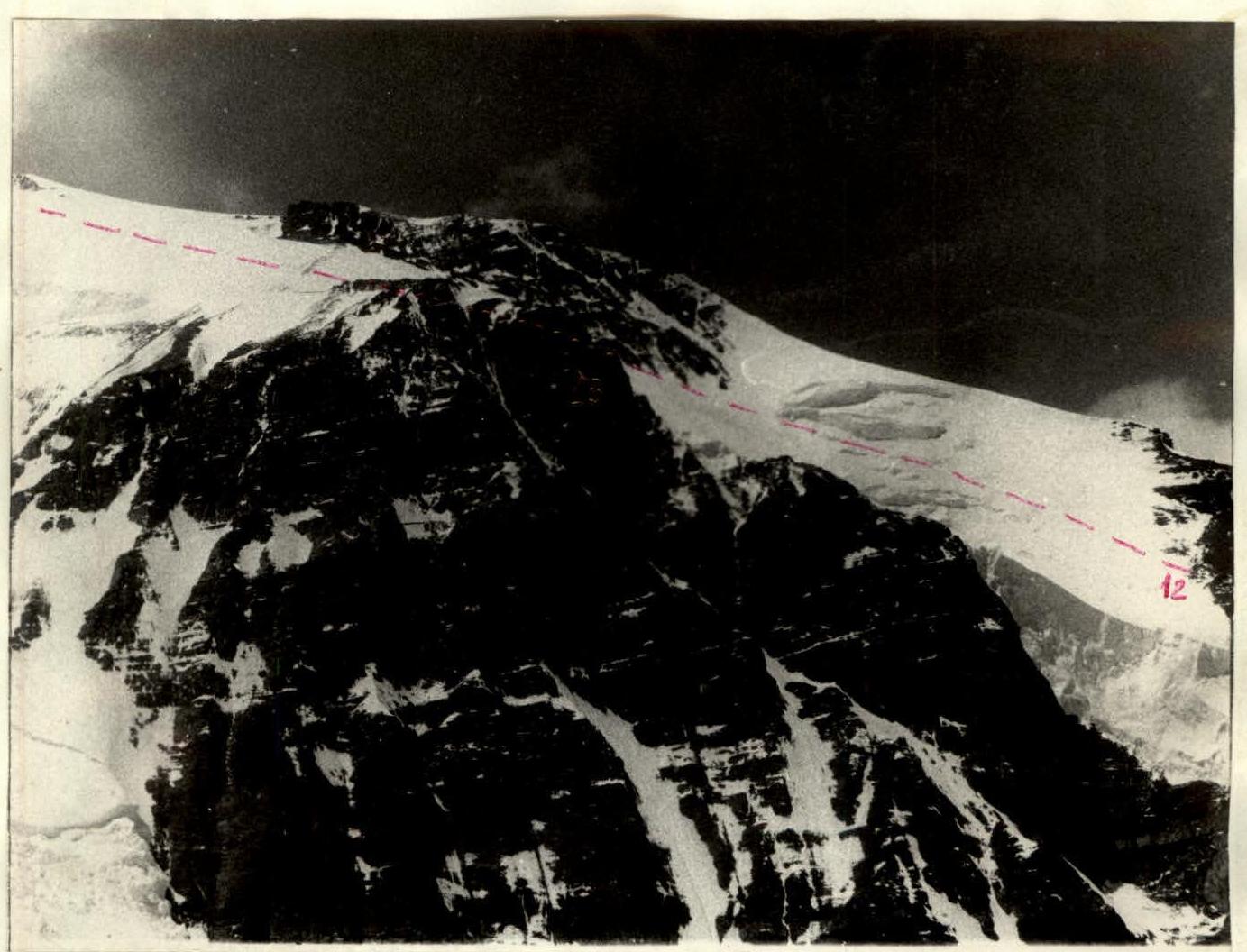
Bergschrund, 1st and 2nd rocky outcrops
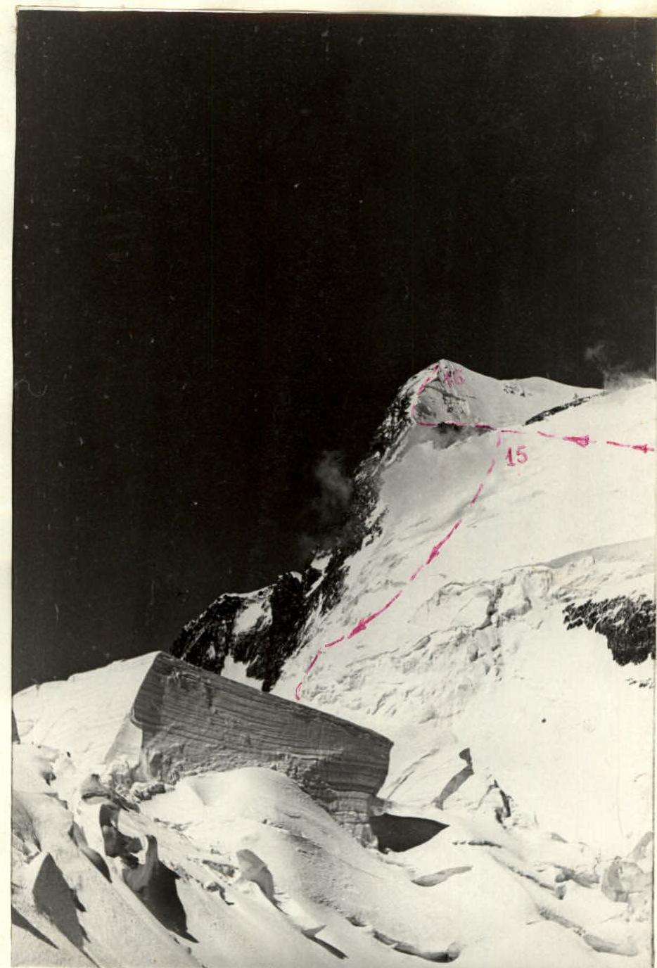
Path along the ridge after the wall
Summit and descent path onto the plateau