Committee for Physical Culture and Sports under the Council of Ministers of the Tajik SSR
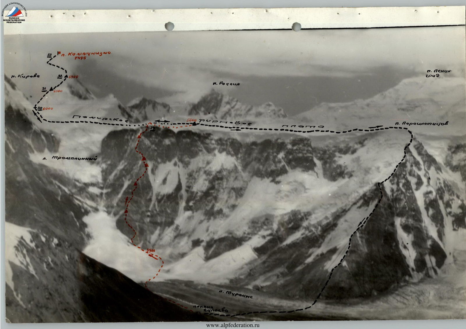
Peak Communism
First ascent from the north with an exit to the Pamir Plateau along the wall to the right of the Trampolinny Glacier
I. General Characteristics of the Route and Walls
The ascent route passes to the right of the Trampolinny Glacier, along the northern wall of the Pamir Firn Plateau, with an exit to the plateau, and further, through the Big Barrier, to the summit of Peak Communism.
The ascent along the wall with an exit to the plateau is a first ascent. The further ascent to the summit through the Big Barrier is part of the classified route of ascent to Peak Communism from the north via the so-called "Burevestnik Ridge" 5B category of difficulty.
The Pamir Firn Plateau with an average elevation of 5800–6100 m (according to literary sources) drops steeply to the north onto the Turamys Glacier with a steep rock-ice wall.
Sides of the wall:
- To the east, it is dissected by the discharges of the Trampolinny Glacier, separating it from Peak Kirova;
- The western part is somewhat flattened, forming a clearly defined ridge (the so-called "Burevestnik Ridge"), along which the 5B category route to Peak Communism passes.
The top of this ridge is called Peak Parachutists.
The main technical difficulty in ascending Peak Communism from the north, both along the Burevestnik Ridge and along the new route, is the exit to the plateau.
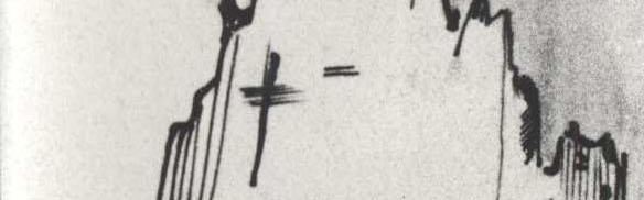
Almost the entire wall is overhung by the plateau, forming ice walls 40–100 m high. Periodically, firn blocks break off and fall, breaking into dust and forming snow-ice avalanches. The frequency of avalanches depends on the movement of firn on the plateau, weather, precipitation, etc. On average, about once an hour, an avalanche passes somewhere along the wall. Avalanches also occasionally occur from the Trampolinny Glacier, sometimes reaching significant sizes. The total length of the wall from the Trampolinny Glacier to the Burevestnik Ridge is about 6 km. The steepness of the wall varies. Generally, the part of the wall, approximately up to the middle of its extent from west to east, has a steepness of 60°. The eastern part of the wall has a steepness of 70°. The upper half of the wall throughout its extent is steeper than the lower half. Moreover, the upper part of the eastern wall often approaches a sheer drop. The wall has several rock counterforts. The ascent route passes along the third counterfort (counting from the Trampolinny Glacier) and begins at the confluence of the Trampolinny Glacier and the Turamys Glacier. As seen from the photos, this ascent option is the safest and most logical both in terms of avalanche danger and the possibility of ice falls. This is because the route leads to the highest point of the plateau, due to which the firn plateau, "overflowing" in lower areas, does not reach the top of the rock wall here. No significant rockfalls were observed along the wall where the route passes, although such rockfalls were noted on the routes of neighboring peaks — Peak Kirova, NKVD.
The character of the rock formations changes with height. Layers of rocks with different characteristics are clearly visible:
- Different colors,
- Different degrees of destruction,
- Different degrees of hardness.
The route is very logical. Deviations from it are possible only after reaching the top of the "striped" gendarme (see description) with a move to the right. However, this option is not recommended due to its greater difficulty and danger.
The exit to the plateau is also recommended along the traversed path because an exit to the left after the last night's camp (end of section R23–R24) is associated with overcoming a significant section of rocks covered with ice, passes under cornices, and is dangerous. The ascent in this case is associated with overcoming an ice wall 40–50 m high and cornices, which presents significant technical difficulty.
Description of the Ascent Route
The entire route can be divided into three major parts, sharply differing in the degree of technical complexity, height, and method of overcoming. These parts are: the wall, the plateau, the Big Barrier, and the summit.
I. The Wall
Approaches to the counterfort — the beginning of the route through the Turamys Glacier take 1 hour 30 minutes. During the approaches, it is necessary to "veer" to the right, under the wall, bypassing the zone of action of avalanches from the Trampolinny Glacier.
The glacier at the end of the approaches is significantly broken, and maneuvering among crevices takes a lot of time. With a small amount of snow in some places, crampons may be required.
Before exiting, it is necessary to study the glacier's regime. According to observations, large avalanches descended early in the morning, which led to a late start on the route — at 9:00.
In general, the route along the wall can be divided into a number of large sections, also differing in the form of relief and degree of complexity. Such sections can be called:
- The counterfort, which is the beginning of the route, having a clearly defined triangular shape;
- Wall I, to which the counterfort is connected by a short bridge. The wall consists of two belts — rocks of white and black color, clearly visible from the base camp;
- The Central Ridge, starting from the top of Wall I and ending with the "striped" gendarme;
- Wall II — the upper part of the Northern wall of the Pamir Firn Plateau, the most steep and complex part of the route.
1st day, July 24
I. Counterfort
Section R0–R1
The beginning of the route on the counterfort — monolithic overhanging rocks of yellow color, very hard rock. They are bypassed on the left along the ice of the Trampolinny Glacier. Protection from possible avalanches is provided by ice discharges and crevices of the glacier at the point of contact with the rocks of the counterfort. Throughout the observation period, there were no cases where avalanches touched the counterfort, indicating a high reliability of protection. The ice with a steepness of 40°–50° is traversed on crampons, sometimes with step-cutting. Movement is alternating, teams work independently, insurance is with pitons, using rock pitons driven into the rocks of the monolith. Length — 110 m, difficulty — 3B, time to pass — 1 hour 30 minutes, 7 pitons driven.
Section R1–R2
The bypass of the overhang continues until reaching the beginning of a wide, strongly inclined (up to 50°) shelf, rocky, местами covered with ice and snow. The counterfort is traversed along the shelf to the right and upwards. Length — 80 m, movement is alternating, teams work independently, insurance is with pitons (4 pitons). Time to pass — 1 hour. Steepness of rocks — 50°, difficulty — 3, time to pass — 1 hour.
Section R2–R3
Not reaching the end of the shelf, movement continues straight up, onto the ridge crossing the counterfort from right to left upwards. Length — 100 m (2×50), steepness — 70°, difficulty — 4A. Movement is alternating with the hanging of belays, insurance is with pitons (5 pitons), time to pass — 2 hours. Rocks are significantly destroyed (large form), rock is strong.
Section R3–R4
Rocks of the ridge are destroyed (large form), rock is strong. Length of the section — 300 m, steepness — 50°, movement is alternating, insurance is for ledges, difficulty — 2, time to pass — 1 hour.
Section R4–R5
At the end of the ridge, the character of the rocks changes sharply. The rock is soft, white, crumbles, with a small form of destruction. The ridge ends, turning into a white wall. Movement is straight up, steepness — 70°, length — 90 m (1×60 + 1×30), difficulty — 4B, time — 2 hours 30 minutes. Movement is alternating, with the hanging of belays. Insurance is with pitons (8 pitons).
At the end of the section — an overnight stay. Further movement is not advisable because, according to observations from below, there are no suitable platforms over a significant distance.
2nd day, July 25
2. Wall I (belt of white and black rocks)
Section R5–R6
From the overnight camp, movement is along a vaguely expressed ridge, to the right of it, bypassing the gendarme. Length — 65 m, steepness — 50°, difficulty — 2, rocks are light-colored, destroyed (large form). Movement is alternating, teams work independently, insurance is for ledges, time — 30 minutes.
Section R6–R7
The ridge abuts against the wall. Rocks are white, monolithic, the rock is marble-like limestone, steepness — 65°, length — 125 m (1×60 + 1×65). Movement is alternating, with the hanging of belays, insurance is with pitons (8 pitons), time — 2 hours, difficulty — 4A.
Section R7–R8
Movement is in the direction of the beginning of a narrow and often interrupted shelf, more like an inner corner, crossing the wall from left to right upwards and passing between the dark spots described above, standing out against the light background of the belt of marble-like rocks. The upper part of the belt is traversed along a steep (75°) wall with a length of about 40 m, and weakly destroyed (large forms of destruction). The total length of the section — 200 m, time to pass — 4 hours.
During the passage, the following were used:
- Belays,
- 14 pitons driven.
In some places on the shelf, there were sections of ice, which were chipped away with a hammer. Category of difficulty of the section — 4B.
Section R8–R9
A small section (15 m) of sheer and overhanging rocks of dark color is traversed using ladders and pulling up backpacks. 7 pitons driven, time to pass — 1 hour 30 minutes, category of difficulty — 5B. The section leads to a small inclined shelf where part of the group can be accommodated (see diagram № 1). Rocks are monolithic.
Section R9–R10
To the right of the shelf, a groove-chimney with a steepness of 60° and a length of 60 m goes up to the left. The ascent is along its left part. 5 pitons driven, time to pass — 2 hours, category of difficulty — 4B. Rocks are monolithic, of hard rock.
Section R10–R11
The chimney leads to the beginning of a rock-ice couloir with a steepness of about 50°, gradually increasing in its upper part. Rocks are dark-colored, weakly destroyed (large form of destruction), category of difficulty — 3. Length of the section — 150 m, time to pass — 2 hours. 4 pitons driven.
Section R11–R12
The couloir leads to a ridge on the left, along which (15 m) we approach a snow wall with a length of 60 m and a steepness of 70°. Passage of the section took 1 hour, category of difficulty — 4B, 3 pitons driven. The wall leads to a large shelf with a steepness of about 30°, covered with large rock fragments. Part of the shelf is occupied by snow, from the melting of which streams flow down the traversed wall, forming ice accretions by morning. The elevation of the shelf is 4910 m.
By 20:00, the group was assembled and began to organize an overnight stay. Setting up platforms for tents took about 2 hours.
It should be noted that this is the only place convenient for organizing an overnight stay encountered along the route of the second day.
3rd day — July 26
Section R12–R13
From the overnight camp, to the right and upwards, 100 m along weakly destroyed rocks (large form of destruction) with a steepness of 60°, with alternating insurance through ledges, we exit to the ridge. Time to pass — 1 hour 30 minutes, category of difficulty — 3.
III. Central Ridge
Section R13–R14
In some places, a very narrow ridge is composed of rocks of hard rock, steepness of the section — 65°, there are sections of sheer rocks with a length of 10–15 m. Movement is with piton insurance and use of belays. Difficulty of the section — 5A, length — 140 m, time to pass — 5 hours, 16 pitons driven. The section leads to the base of a gendarme with smooth, steep walls.
Section R14–R15
Before Wall II, the steepness of the ridge and its difficulty increase sharply — this is a place like a small break. At this place, there is a sheer gendarme with smooth walls on the ridge. From the gendarme, a discontinuous narrow shelf goes down to the right, traversing to the right from the ridge, descending into a steep couloir. In the couloir, the rocks have a bluish-gray hue, so the couloir is called "blue." Descent into the couloir is with the hanging of belays and piton insurance (5 pitons).
Length of the section — 60 m (1×60). Steepness of rocks — 70°. Difficulty of the section — 4B. Time to pass — 1 hour. Rocks are of hard rock, местами destroyed (large form of destruction).
Section R15–R16
IV.
The "blue" couloir starts under the "Striped Gendarme" and ends a little below the point of descent into it along the route. In plan, it has an arcuate shape, going to the right at the beginning of the couloir. Rocks are of hard and soft rock, with step-like formations 2–3 m, allowing shelter from possible rockfalls from the "Striped Gendarme" (no rockfalls were observed during the group's passage). The average steepness of rocks and the section — 60°, length — 120 m (2×60). It is traversed with alternating piton insurance (8 pitons) and hanging of belays. The ascent route passes along the left (in the direction of travel) side of the couloir at the junction with the ridge. Time to pass — 2 hours 30 minutes, category of difficulty — 4A. In the upper part, the couloir sharply increases in steepness (up to 70°–75°) and ends under the "Striped" gendarme.
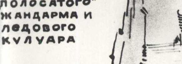
Section R16–R17
(see diagram № 3, photo № 1–№ 3). The gendarme, about 150 m high, standing before Wall II at the end of the ridge of the central part of the wall (above the "blue couloir"), is composed of rocks of soft, brittle rock of different light colors, going in numerous horizontal stripes. For these stripes, the gendarme is called "striped." The fragility of the rock requires special attention during movement and insurance organization.
The rocks are very steep, almost sheer, dissected by canyons of ice couloirs. It is separated from Wall II by a steep ice couloir, leading to a very short (10–15 m) ice bridge. The gendarme is traversed alternately to the right in the direction of travel, up to the middle of its height.
Length of the section — 100 m (2 × 40 + 1 × 20). Steepness of rocks — 75°, difficulty — 5B. Insurance is with pitons (14 pitons). Time to pass — 4 hours, backpacks are pulled up.
The overnight stay is organized in the lower part of the gendarme, 60 m above the "blue couloir" (1 × 40 + 1 × 20). Time to pass the section to the overnight stay — 2 hours 30 minutes, 10 pitons driven.
4th day — July 27
Section R17–R18 (see diagram № 3)
From the middle of the "striped gendarme," a traverse follows with a descent into the ice couloir passing between it and Wall II. The descent is forced because the gendarme further is composed of completely sheer rocks, brittle, not providing reliable retention of driven pitons and wedges.
The couloir has to be traversed with almost continuous step-cutting