Championship of the USSR in Alpinism, High-Altitude Class
Report of the CS DSO "Mehnat" Team on the Ascent to Peak Kommunizma 7495 m via the NE Counterfort.
Team Captain: VORONIN V. G.
Team Coach: ZEL'CHIEVKOV V. A.
Pamir - Tashkent 1970
THE TEAM DEDICATES ITS ASCENT ON PIK KOMMUNIZMA 7495 m TO THE XXIV CONGRESS OF THE CPSU
I. Route Description.
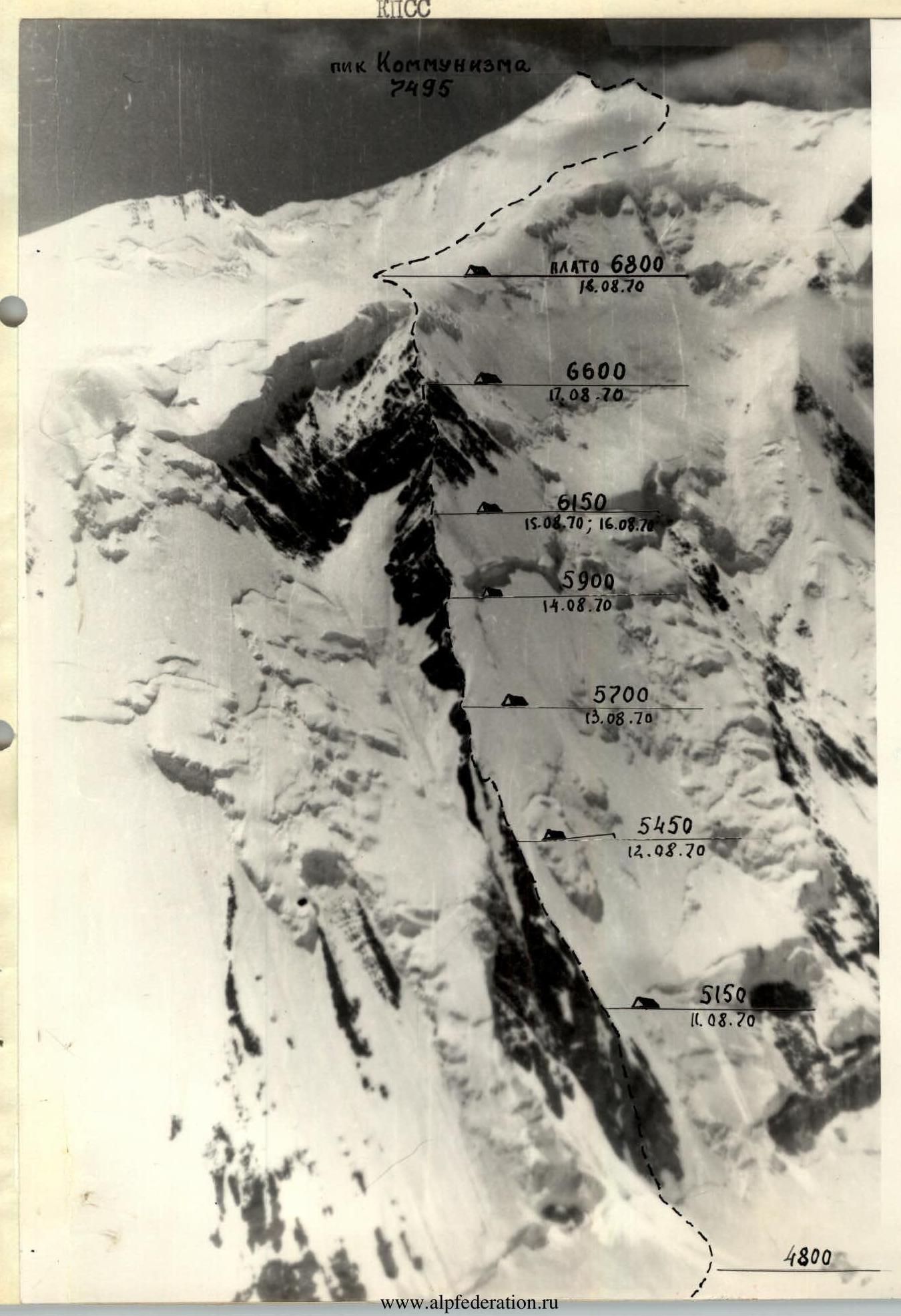
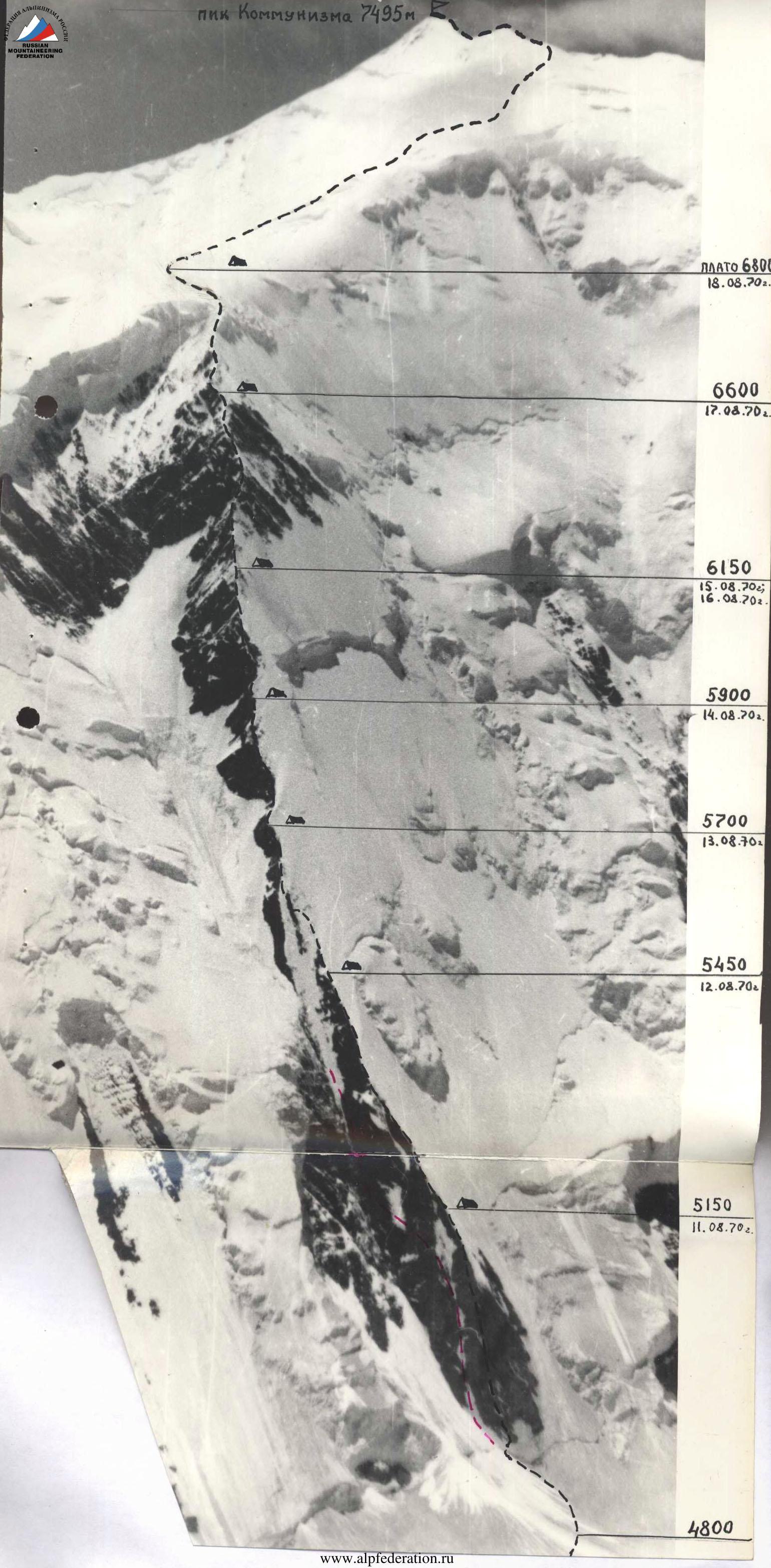
August 10, 1970 - Approach from the Base Camp to the route.
August 11, 1970 - Start of the route (R0–R1) on a snowy slope transitioning into an icy slope, bypassing the avalanche cone on the right.
Crossing a 2-meter bergschrund on ice axes and ascent up the icy slope to the rocky base of the NE counterfort (R1–R2).
The left bastion of the base appears very accessible. However, due to the danger of icefall and constant rockfall, the route is taken via the right bastion. The boundaries of the hazardous area, marked on photo 4.1 with a red dotted line, were determined after two observed rockfalls during a reconnaissance sortie.
It's necessary to start the ascent on the counterfort early in the morning.
The rocky bastion (R2–R3) consists of steep, partially destroyed rocks covered with sparse ice accretion. There are:
- relatively convenient platforms for belaying;
- sufficient number of cracks for piton placement.
The rocks are brittle, requiring careful testing during movement.
Extended pitons are used, and occasionally standard ones. The bastion is ascended via the left convex rounded edge.
On August 17, 1970, during processing, ropes were hung on 2/3 of the bastion's height. On August 11, 1970, the processed part was passed, and then the rest of the bastion was traversed. The route is equipped with continuous fixed ropes, and progression is aided by jammers. Rucksacks are pulled up using an improved block-brake with a jammer.
In some places, rucksacks need to be:
- pulled away from the rocks to avoid jamming;
- prevented from triggering rockfalls.
On the R2–R3 section (upper part), a semi-reclining bivouac is set up to the left of the ridge on a rocky ledge cleared of ice and embedded rocks. The ledge is sloping, so a 0.5 m wall is built to level it.
August 12, 1970 - The path continues along the edge of the wall (R3–R4), which drops vertically to the left, and a steep icy slope. The section is mostly traversed on rocks. The rocks are individual boulders and stones cemented by ice. Occasionally, it's necessary to traverse the icy slope with step-cutting. There are very few cracks on the rocks for piton placement. Metal wedges are used, hammered into the wall below the edge level, which is quite inconvenient. Ice piton placement is avoided due to the thin ice layer and its tendency to flake off.
The edge is interrupted by a concave bend in the rocky wall, covered with ice accretion (R4–R5). The ice is thin, but rocks are barely visible, with only occasional protrusions and stones. In some protrusions, cracks can be found for piton placement.
The section is traversed on crampons on ice with step-cutting from one protrusion to another. Step-cutting is challenging due to the ice's tendency to flake off.
Ice pitons are placed only after:
- removing the top layer of ice (15–20 cm);
- and only in areas where the ice is thick enough for this operation.
The wall's bend is traversed upwards to the left, in the direction of the edge's continuation.
The continuation of the edge (R5–R6). After the R5 section, an icy ridge is notable, transitioning into an icy slope, which abuts a rocky wall, bypassing it on the right. The wall and slope form an obtuse angle, making it very difficult to traverse the edge. The amount of ice accretion on the rocks increases.
Forty meters before the end of the rocks, we descend to the left down to a ledge via a vertical wall, where, after clearing ice and building a 1.5-meter stone structure from available debris, we create a small platform. Although cramped, we manage to spend the night almost lying down.
Three team members worked on the platform for 2 hours. Voronin and Luman hung two ropes above during this time.
August 13, 1970 - From the bivouac, the edge continues for another rope length (R6–R7). In the middle of the section, there's a rocky step. It's not very high (3 m), but it's traversed with great effort due to the 90-degree overhang covered with icicles.
The icy gully (R7–R8). 1/3 of it is processed in the evening. The ice is steep and very brittle:
- the first climber, wearing crampons, carefully cuts steps;
- large depressions are cut out under the pitons;
- pitons with loops are used to facilitate rope pulling.
The fixed ropes are taut, without any sagging, as the path traverses in the direction of the rocky knife (R8–R9), resembling a prehistoric lizard's ridge protruding from the ice.
The knife is steep, up to 80 degrees in the lower part, and very sharp. Traversing it is complicated by a significant amount of ice accretion, which is constantly chopped off with an ice axe to find holds, footholds, and cracks for pitons.
This knife protrudes from the icy gully. From its upper part, we continue on similar ice as in the main gully (R9–R10). However, there are protruding stones here, and the path proceeds from one protrusion to another much faster. We again reach the contact between rocks and ice (R10–R11). And once more, we're faced with familiar ice accretion hiding necessary irregularities on the rocks for belaying and movement. Again, the laborious work with an ice axe is required to clear necessary protrusions and cracks.
The day is coming to an end; it's time to think about a bivouac. Ahead lies an icy gully (R11–R12), preceded by an icy ridge that diverges to the right from our direction and transitions into an icy slope above. After spending over an hour, we create a platform in the slope of this ridge for a bivouac and, having placed ice pitons for belaying, spend the night in a sitting position.
During the preparation of the platform, B. Bloshtein and Putinchev processed the upcoming icy gully (R11–R12). This was a day of continuous fixed ropes.
August 14, 1970 - Morning. Surprisingly good weather. Until now, daily systematic clearances were followed by snow squalls and fog.
The icy gully (R11–R12) is traversed quickly via the pre-installed fixed ropes. The path is eased by the steps cut out the previous day.
Again, familiar terrain (R12–R13) - contact between a vertical wall and an icy slope. Ice accretion. Occasional step-cutting. Clearing holds, footholds, and cracks from the now tiresome ice. Extended pitons are used.
Next - a series of 4 icy gullies, alternating with steep rocky ridges (R13–R14).
In the gullies:
- step-cutting;
- ice piton placement.
The ice structure is similar to that in the previous gullies. The rocky ridges - or rather, large and small fragments of stones embedded in ice - are challenging to overcome due to their fragility and steepness.
The load on the supports is only vertical.
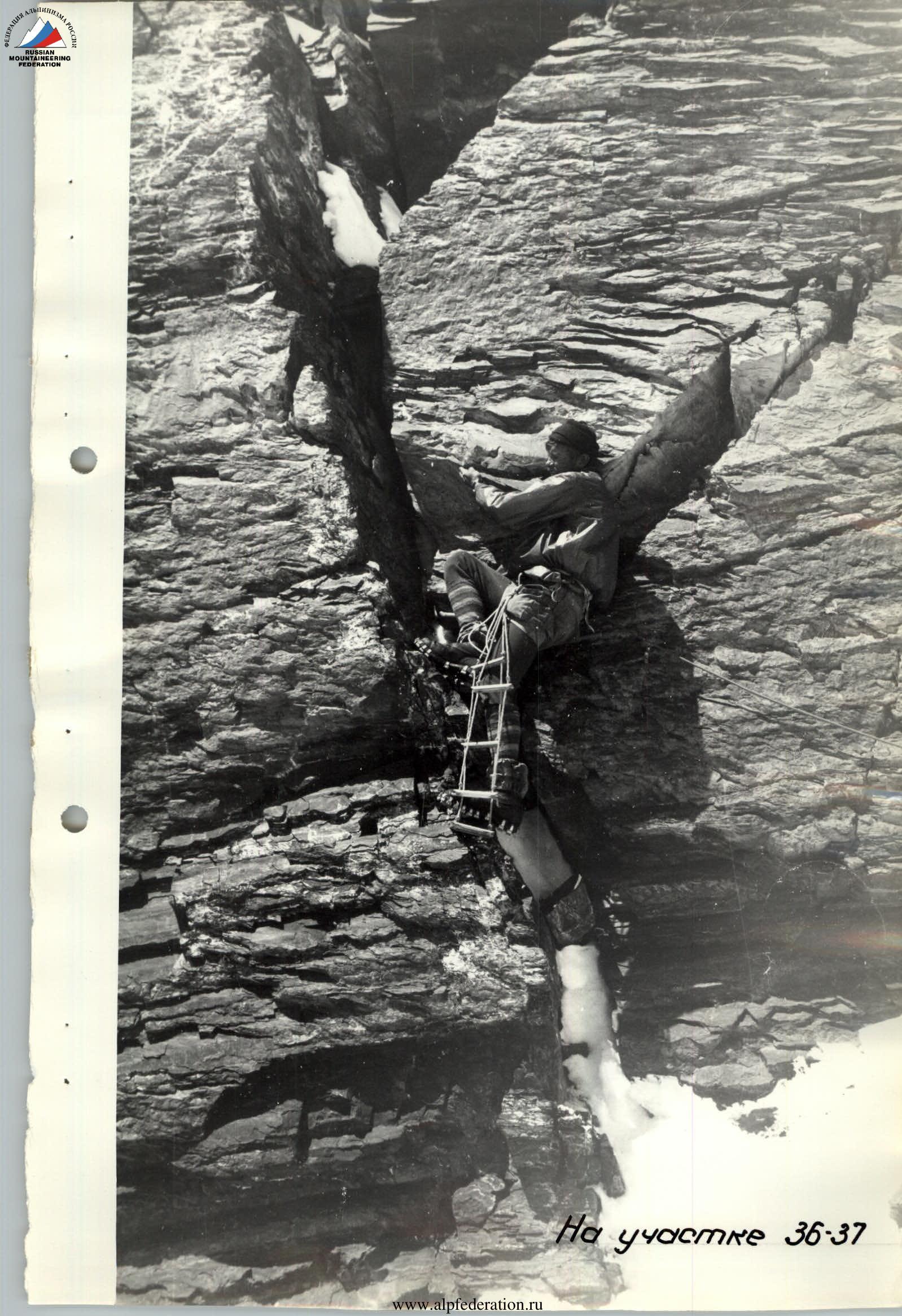
A sheer rocky wall (R14–R15), with occasional areas of reduced steepness - a "heel" of ice. The rocks are very challenging. At the end of the section, there are slightly overhanging areas requiring the installation of a 10-meter ladder. The first climber ascends these 10 meters using stirrups. Rucksacks are pulled up through a block-brake.
That night, we bivouac on a steep slope, where a platform is built 1.5 meters high using stones and ice fragments. We again spend the night sitting, insured as a precaution. A control note is left at this bivouac site.
August 15, 1970 - The weather seems to be treating us kindly. Again, clear skies. Directly above the bivouac, there's a steep icy slope (R15–R16), abutting sheer rocks (R16–R17).
At dawn - the sun appears on the route daily at 6:10. Restless Borya Bloshtein gets us on our feet, and after a hasty breakfast, Z. Luman and G. Kalinin set out to overcome the two mentioned sections.
- Fixed ropes are installed.
- Rucksacks are pulled directly from the bivouac, setting up a sort of "cable car" over 80 meters through blocks secured at the start and end of the route.
Ahead, again, there's an icy slope (R17–R18) leading to a rocky slope covered with ice (R18–R19), made up of large blocks (1.5–2.0 m), heavily smoothed. Although the overall steepness of the slope is not significant (no more than 60 degrees), the blocks are difficult to traverse due to the lack of holds. The lower block (about 2.5 m) is particularly notable, onto which the leading climber, Z. Luman, steps with the help of his companions ("elephant" technique). Profiled pitons are used. Rucksacks are pulled up.
A snowy-icy knife-edge ridge of variable steepness from 0 to 60 degrees (R19–R20). We proceed cautiously, as balancing is required. The knife-edge abuts an icy rocky step (R20–R21), representing a vertically placed slab. Only the presence of a convenient crack for piton placement makes it possible to overcome it using stirrups. Rucksacks are pulled up.
Again, a snowy-icy knife-edge ridge (R21–R22) and another rocky step (R22–R23), this time humped, but again lacking necessary irregularities for traversal. Again, stirrups and rucksack pulling.
A snowy cornice is perched on the step, being the end of a new snowy-icy knife-edge. We chop off the cornice and manage to set up a tent more or less tolerably, with:
- 2 lying-down places;
- 3 sitting places.
At night, we swap places to rest evenly.
Preliminary study of the route (photographs, reconnaissance, visual-optical observation from the 6500 m mark on the eastern ridge), as well as the increasing complexity, suggested the absence of suitable bivouac sites after one day's climb, which later proved to be true. We decide to conduct a one-day processing of the route, which promises to be very challenging. Voronin and Putinchev set out for the processing. On this day, strong gusts of wind occasionally blew in. From the bivouac, we watched as the workers above frequently pressed themselves against the rocks, weathering each gust.
During the processing, those remaining at the bivouac expanded it by adding stone masonry to the size of a reclining bivouac.
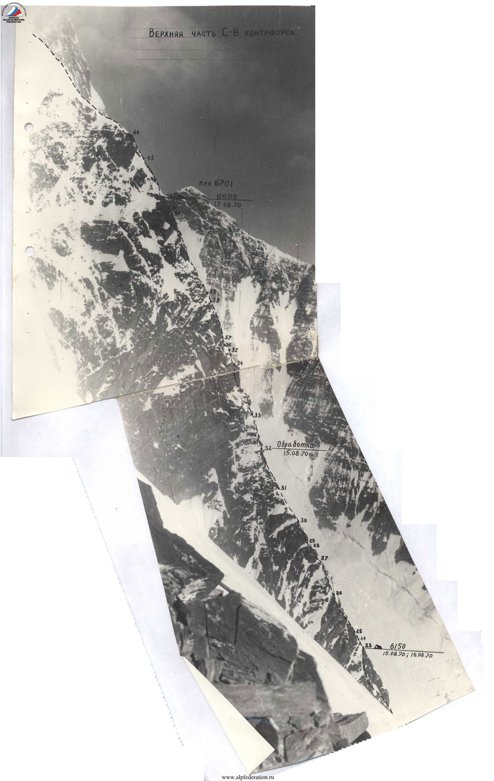
August 17, 1970 - Immediately from the bivouac, a short snowy-icy knife-edge ridge (R23–R24) is followed by a 5-meter overhanging quartz vein (R24–R25), where we barely find thin cracks for petal pitons, and the upper part is traversed using bolt-hole technique. A ladder is hung on this section.
Above, there are steep round rocks with ice accretion (R25–R26). A significant and laborious effort is made to clear the rocks of ice to find necessary cracks for pitons.
Then, a snowy ridge of the lower type (R26–R27). The snow is deep and dry - a surprise for us, having dealt mostly with ice or dense firn until now. Apparently, the presence of snow can be explained by the already significant height and the ridge's orientation, protected from the wind by a negative wall of rocks, intersected by a slightly inclined, not very wide chimney (R27–R28). The chimney doesn't allow for a comfortable fit. Extremely difficult free climbing is required. Rucksacks are pulled up.
Above, there's a short (4 m) ascent of steep ice (R28–R29), where step-cutting is necessary.
Above the ascent, there's a sheer sentinel (R29–R30), towering over the route like an enormous tooth. It's overcome head-on via the wall with a minimal number of cracks. Even with rubber boots, it's impossible to traverse; thus, during processing, bolt-hole technique and stirrups were used. During the group's passage, a ladder is hung, and rucksacks are pulled up.
A snowy-icy slope (R30–R31) with outcrops of glazed rocks leads to a negative wall (R31–R32), where bolt-hole technique, stirrups, and ladders are used. Rucksacks are pulled up. This section completes the previous day's processing.
Next, there's an icy ridge (R32–R33) of considerable length. We proceed in crampons with step-cutting.
A rocky ascent (R33–R34) - the first two meters form a sharp overhang, and above, there's a steep rocky wall with ice accretion. Challenging climbing with piton belays.
Rucksacks are pulled up.
The negative start is overcome using the "elephant" technique.
An icy ridge with steep outcrops of rocks (R34–R35) abuts a sheer wall.
Step-cutting.
From the ridge, a 4-meter icy slope (R35–R36) to the left leads to a diagonal, not very deep chimney in this wall (R36–R37) - very challenging free climbing. The chimney leads to an almost vertical face of the wall (R37–R38). The face represents a sharp outer angle. Rucksacks are pulled directly up the wall. This section is very challenging to overcome without special techniques.
A short icy slope (R38–R39) transitions into a rocky one (R39–R40), which, after the previous sections, seems relatively simple.
After the wall, we're unexpectedly faced with a mysterious phenomenon. The counterfort is cut across its entire width by a deep (60–70 m) crevasse (R40–R41) with completely smooth, vertical walls extending deep into the ground. Fortunately, the width of this crevasse is only 1.5 m; otherwise, its traversal would be a problem.
- Voronin jumps across first;
- then the rest traverse via fixed ropes.
It's already late - we search for a place to bivouac. We ascend another rope length along the continuation of the wall (R41–R42), at the top of which we clear a small platform of rocks, snow, and ice, set up a tent, and spend the night tolerably.
August 18, 1970 - A rocky-snowy-icy ridge (R42–R43) is relatively simple but has a "twist":
- a 2-meter rocky step protrudes;
- under which we again build an "elephant" for the last time.
The ridge transitions into a rocky-snowy-icy slope (R43–R44). We traverse the ridge and slope in pairs, alternately, belaying through protrusions. We reach the final rocks of the counterfort. The rocks are slabby and warm. We lie on them for half an hour, warming up in the sun.
A horizontal icy-firn ridge of a typical knife-edge character (R44–R45). We traverse it in crampons, chopping off the sharp part and belaying through ice pitons.
The ridge, gaining steepness up to 45 degrees, abuts a huge icy-firn cornice (R45–R46), onto which we ascend from the left, continuing to cut steps and place ice pitons. Behind this cornice, a second, smaller cornice rises, connected to the first by a simple snowy ridge (R46–R47). We ascend to the second cornice (R47–R48), sinking waist-deep into dry, loose snow.
A firn ridge (R48–R49) transitions into a long, gentle slope (R49–R50) - the 6800 m plateau. At "Uzdarka," with shelters left from the first ascent, we set up a tent. Today was an unprecedentedly short working day - we reached the plateau at 15:00. We rest before the upcoming summit push.
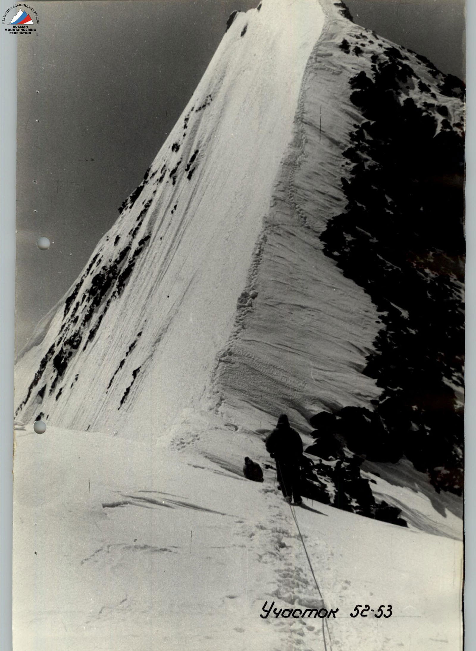
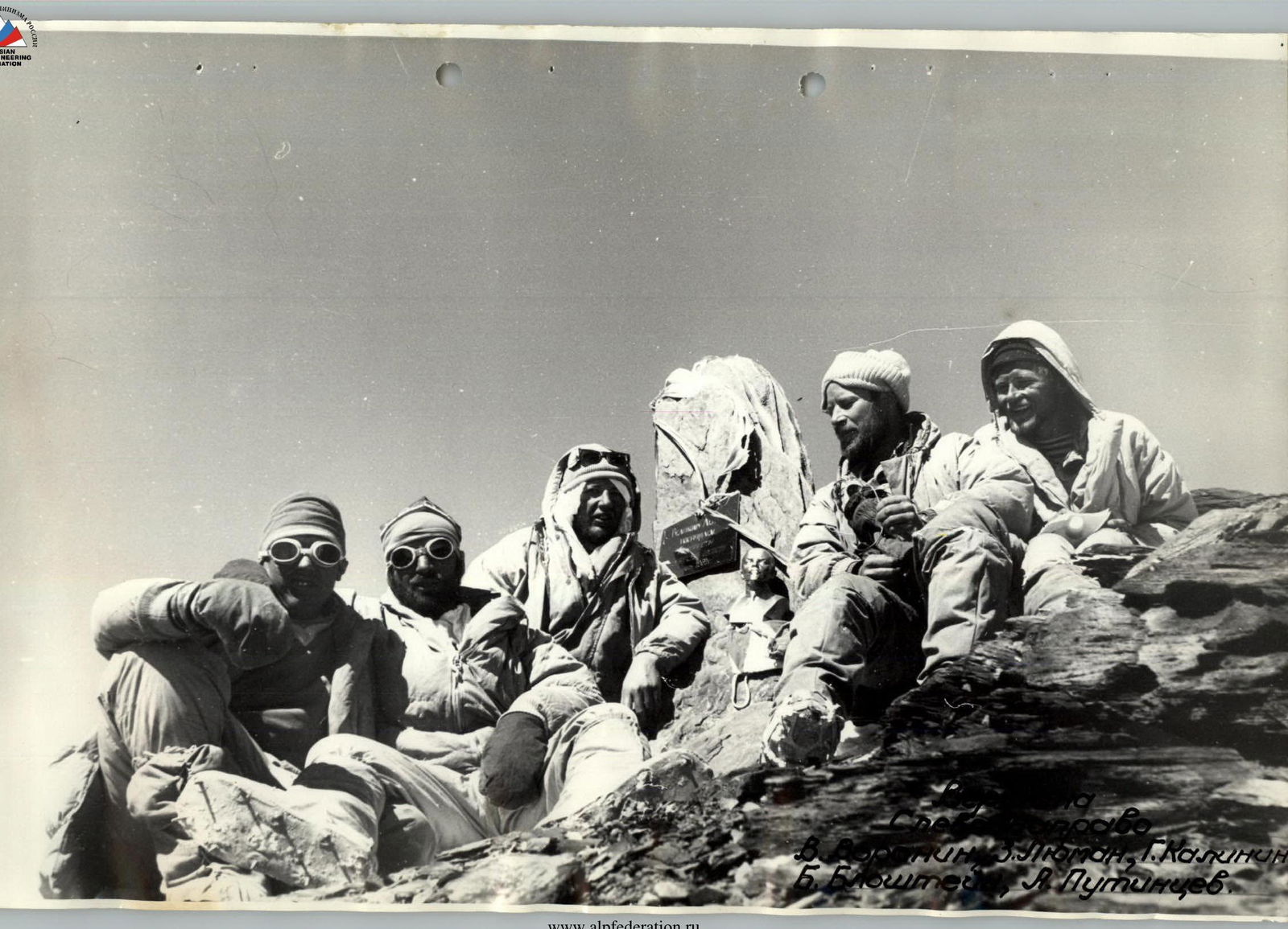
August 19, 1970 - We set out lightly towards the summit. Familiar snowy slopes, ridges, and broad crests (R50–R51) lead to the pre-summit ridge (R51–R52). Along it, we approach the summit ascent (R52–R53). We follow clear tracks, indicating that several groups have already ascended here. We reach the summit at 14:45, spend about 30 minutes there, and then return to our tent.
August 20, 1970 - Descent via the eastern ridge to the Base Camp, where friends warmly greet us, having prepared:
- an abundant table;
- a festive cake.
VI. Overall Assessment of Participants' Actions During the Ascent.
Team members have known each other for many years, undertaking complex ascents together in expedition conditions. They are physically and technically well-prepared. Acclimatization was achieved through a prior ascent of Peak Kommunizma via E. Abalakov's route. Each participant knew and clearly performed their duties.
Within the team, there were individuals with inclinations towards traversing specific types of terrain (snowy, icy, or rocky), performing their tasks with pleasure and virtuosity. They led on their preferred sections.
For example, Putinchev, a native of Krasnoyarsk, raised on the rocks of Stolby, a prize-winner at the 1965 USSR Climbing Championship, led on the most complex rocky sections. Even in rare instances where there was no ice on the rocks, he used rubber boots, unusual for a high-altitude route. Luman, a participant in the ascent, is a significant specialist in traversing snowy-icy terrain.
Utilizing the sports talents of the participants, the team quickly and qualitatively overcame even the most complex sections, minimizing time, effort, and special equipment.
It's worth noting that the ascent participants, Kalinin and Bloshtein, with three cameras equipped with interchangeable lenses, excelled in photography despite the route's complexity.
During the ascent, everyone enjoyed excellent health, sleep, and appetite. The team's cohesion, outstanding technical and moral preparation of the participants allowed for a safe and stylish ascent.
Team Captain MS -
Coach of the team, Honored Coach of UzSSR MS -
V. Voronin G. Kalinin A. Putinchev www.alpfederation.ru↗
VIII. Additional Data on the Route.
The route taken by the team is flanked by icefalls on the NE wall, which, however, do not pose an objective danger to its passage.
These icefalls and the route's complexity apparently did not attract the attention of previous groups visiting this area.
Studying photographs taken in 1964 during the ascent of Peak Izvestiy, as well as thorough reconnaissance, clarified that the route via the NE counterfort is quite safe, technically complex, logical, and very interesting from a sports perspective.
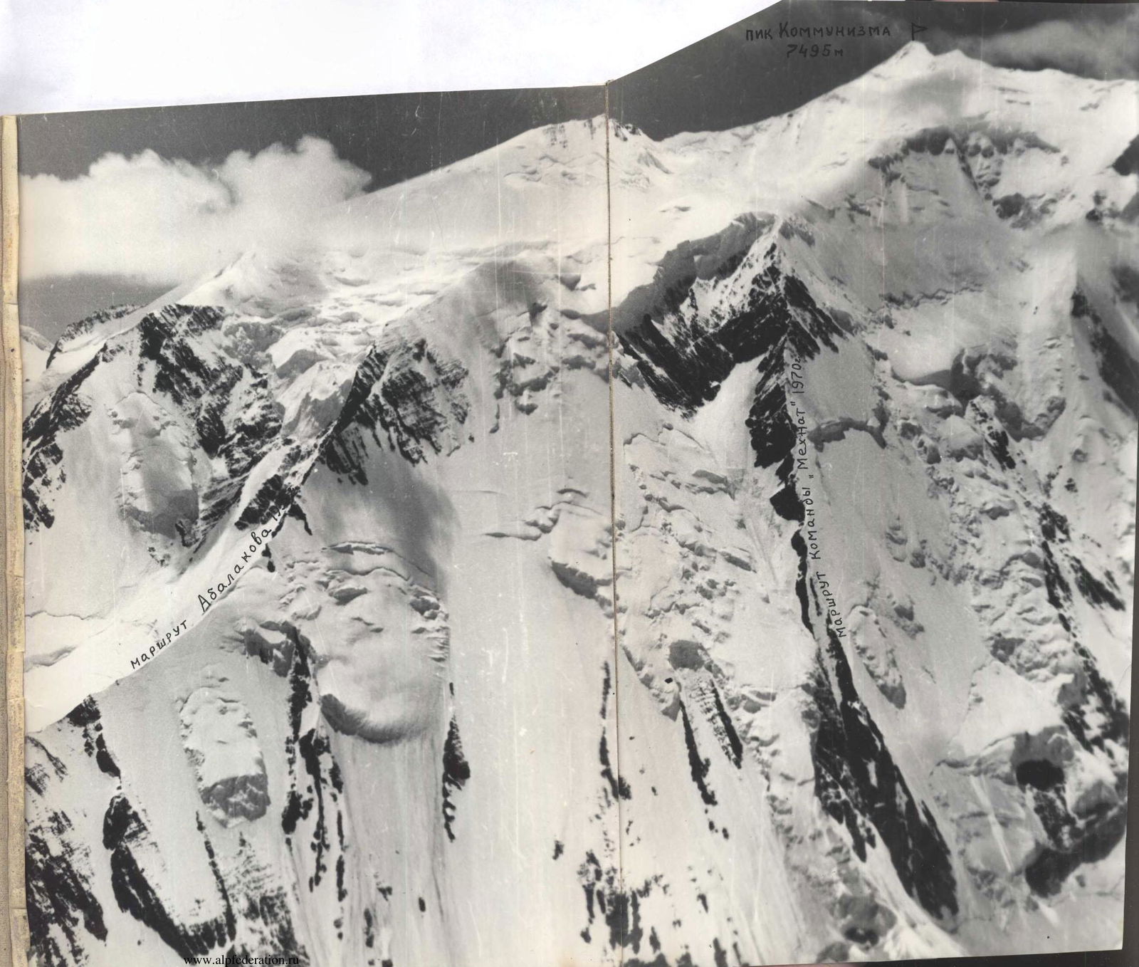
To accurately determine the category of complexity of the route, it's very convenient to compare it with neighboring routes on Peak Kommunizma:
- via the eastern ridge (E. Abalakov, 1933, 5B category);
- via the eastern counterfort (P. Budanov with a group, 1968, 6B category).
The route via the northeast counterfort is significantly longer and steeper than each of these.
After 14:00, the route receives no direct sunlight.
The team's achievements in high-altitude and technical ascents include the following:
- Peak Izvestiy 6840 m - 5B category;
- Peak Voroshilov 6662 m - 5B category;
- Peak Kommunisticheskoy Akademii 6439 m - 5B category;
- Peak Lenin 7134 m via various routes, including 5B category from the south through Peak 6852 m;
- Peak Evgeniy Korzhenevskoy 7105 m - 5B category;
- Peak Oktyabr'skoy Revolyutsii 6983 m - 6B category and from the southwest through Peak Shipka - 5B category;
- Peak Pobeda 7439 m via the northern ridge;
- Peak Kommunizma 7495 m via the eastern ridge.
Moreover, routes on peaks Izvestiy, Kommunisticheskoy Akademii, Lenin from the south, Korzhenevskoy, and Revolyutsii with 10.3 were traversed by team members as part of pioneering groups. The new route on Peak Kommunizma via the NE counterfort is considered by the team to be the most challenging of those previously traversed and is rated as a 6B category route.
On behalf of the team, Team Captain MS - V. Voronin MS - G. Kalinin CMS - A. Putinchev
Table
Key Characteristics of the Ascent Route
Ascent Route: Peak Kommunizma via the northeast counterfort
Height Difference of the Route: 2695 m
Including complex sections: 1670 m, of which the most complex are 295 m (the mass of small walls with lengths from 2 to 7 m on other sections are not included in this sum of the most complex sections).
Steepness of the Route:
- Counterfort - 60 degrees
- Upper part - 28 degrees
| Dates | Sections | Avg. Steepness | Length (m) | Terrain Characteristics | Difficulty | Method of Passage | Weather | Time of Bivouac Setup | End Time | Working Hours | Pitons: Rock | Ice | Bolt-Hole | Weight (g) | Bivouac Conditions |
|---|---|---|---|---|---|---|---|---|---|---|---|---|---|---|---|
| 11.08.1970 | R0–R1 | 45° | 40 | Snowy-icy avalanche cone | Easy | Crampons, in pairs | Cloudy, occasional fog, squalls | 6:45 | Rocky ledge | ||||||
| 11.08.1970 | R1–R2 | 50° | 30 | Icy slope | Medium | Crampons, steps, alternately | Fog, squalls (waited out for 3 h 30 min in total) | 1 | 2 | Semi-reclining | |||||
| 11.08.1970 | R2–R3 | 50° | 350 | Rocky bastion | Hard | Pitons, fixed ropes | 17:35 | 7:40 | 38 | 650 | |||||
| 12.08.1970 | R3–R4 | 60° | 120 | Contact between rocky wall and icy slope | Hard | 6:50 | 14 | Rocky ledge, semi-reclining | |||||||
| 12.08.1970 | R4–R5 | 70°/55° | 120 | Rocks covered with ice | Hard | Waited out bad weather (2 h 15 min) | 6 | 7 | |||||||
| 12.08.1970 | R5–R6 | 60° | 160 | Contact between rocky wall and icy slope | Hard | 17:50 | 8:45 | 16 | |||||||
| 13.08.1970 | R6–R7 | 60° | 20 | Hard | 7:45 | 2 | Icy slope (sitting) | ||||||||
| 13.08.1970 | R7–R8 | 70°/60° | 120 | Icy slope | Medium | Crampons, steps | 12 | ||||||||
| 13.08.1970 | R8–R9 | 60° | 40 | Rocky knife | Medium | Pitons, alternately | Waited out bad weather (1 h 10 min in total) | 3 | |||||||
| 14.08.1970 | R9–R10 | 70° | 40 | Icy-rocky slope | Medium | Crampons, steps, pitons, fixed ropes | 1 | 2 | |||||||
| 14.08.1970 | R10–R11 | 60° | 60 | Contact between rocky wall and icy slope | Hard | 16:10 | 7:15 | 7 | 650 | ||||||
| 14.08.1970 | R11–R12 | 70°/45° | 40 | Icy gully | Hard | Clear | 8:30 | 1 | 3 | Icy-rocky slope (sitting) | |||||
| 14.08.1970 | R12–R13 | 60° | 60 | Contact between rocky wall and icy slope | Medium | 6 | |||||||||
| 14.08.1970 | R13–R14 | 70°/45° | 80 | Rocky ridges, icy gullies | Hard | 2 | 1 | ||||||||
| 14.08.1970 | R14–R15 | 80° | 60 | Rocky wall | Very hard | Pitons, stirrups, fixed ropes | 16:20 | 7:50 | 8 | ||||||
| 15.08.1970 | R15–R16 | 60° | 40 | Icy slope | Medium | Pitons, crampons, fixed ropes | Clear | 7:30 | 4 | Snowy-icy knife | |||||
| 15.08.1970 | R16–R17 | 80° | 40 | Rocky wall | Hard | Pitons, fixed ropes | 7 | ||||||||
| 15.08.1970 | R17–R18 | 55° | 60 | Icy slope | Medium | Pitons, crampons, fixed ropes | 1 | 3 | Lying down in turns | ||||||
| 15.08.1970 | R18–R19 | 60° | 40 | Rocks covered with ice | Hard | Pitons, "elephant", fixed ropes | 5 | ||||||||
| 15.08.1970 | R19–R20 | 60° | 40 | Snowy-icy knife | Medium | Steps, pitons, fixed ropes | 2 | ||||||||
| 15.08.1970 | R20–R21 | 80° | 20 | Snowy wall | Very hard | Pitons, stirrups, fixed ropes | 6 | ||||||||
| 15.08.1970 | R21–R22 | 60° | 40 | Snowy-icy knife | Medium | Steps, pitons, fixed ropes | 2 | ||||||||
| 15.08.1970 | R22–R23 | 80° | 20 | Rocky wall | Very hard | Pitons, stirrups, fixed ropes | 18:50 | 11:20 | 6 | ||||||
| 16.08.1970/17.08.1970 | R23–R24 | 60° | 10 | Snowy-icy knife | Hard | Pitons, steps, fixed ropes | 16.08.1970: Strong gusty wind with drifting snow | 8:40 | 1 | 1 | Snowy-icy knife (lying) | ||||
| 16.08.1970/17.08.1970 | R24–R25 | 95° | 5 | Negative rocks | Very hard | Pitons, stirrups, fixed ropes | 3 | 1 | |||||||
| 16.08.1970/17.08.1970 | R25–R26 | 60° | 60 | Rocky wall | Hard | Pitons, fixed ropes | 17.08.1970 | 7:10 | 14 | ||||||
| 17.08.1970 | R26–R27 | 45° | 20 | Snowy knife | Medium | Via ice axe, alternately | |||||||||
| 17.08.1970 | R27–R28 | 95° | 10 | Rocky chimney | Very hard | Free climbing, fixed ropes | Clear | 1 | |||||||
| 17.08.1970 | R28–R29 | 75° | 4 | Icy slope | Hard | Steps, fixed ropes | |||||||||
| 17.08.1970 | R29–R30 | 90° | 60 | Rocky wall | Very hard | Pitons, stirrups, fixed ropes | 16 | 3 | Rocky-snowy-icy ridge (lying) | ||||||
| 17.08.1970 | R30–R31 | 45° | 20 | Snowy-icy slope | Medium | Pitons, steps, fixed ropes | 2 | ||||||||
| 17.08.1970 | R31–R32 | 95° | 40 | Rocky wall | Very hard | Pitons, stirrups, fixed ropes | 16.08.1970 | 9:50 | 14 | 2 | |||||
| 17.08.1970 | R32–R33 | 50° | 60 | Icy ridge | Hard | Crampons, pitons, fixed ropes | 6 | ||||||||
| 17.08.1970 | R33–R34 | 85° | 40 | Rocky wall | Very hard | Pitons, "elephant", fixed ropes | 9 | ||||||||
| 17.08.1970 | R34–R35 | 60° | 40 | Icy ridge with rocky outcrops | Medium | Pitons, steps, fixed ropes | 4 | ||||||||
| 17.08.1970 | R35–R36 | 75°/20° | 4 | Icy slope | Hard | Steps, fixed ropes | |||||||||
| 17.08.1970 | R36–R37 | 90° | 20 | Chimney in rocky wall | Very hard | Free climbing, fixed ropes | 4 | ||||||||
| 17.08.1970 | R37–R38 | 85° | 20 | Rocky edge | Very hard | Pitons, fixed ropes | 16.08.1970 | 18:30 | 6 | ||||||
| 17.08.1970 | R38–R39 | 70° | 5 | Icy slope | Hard | Steps, fixed ropes | |||||||||
| 17.08.1970 | R39–R40 | 50° | 40 | Rocky slope | Medium | Pitons, fixed ropes | 17.08.1970 | 18:25 | 5 | ||||||
| 17.08.1970 |