Altai Regional Alpine Federation
For the Championship of the Soviet Union in the class of high-altitude ascents.
Report
on the ascent of Peak Kommunizma (7495 meters) via the counterfort from the Belyaev Glacier (sixth category of difficulty) Barnaul, 1969
I. Brief geographical description and sporting characteristics of the ascent object
In the center of the North-Western Pamir, at the junction of two ridges – Peter the First and Academy of Sciences, on the territory of the Tajik SSR is located the highest peak of the Soviet Union – Peak Kommunizma. The area of Peak Kommunizma, which has a height of 7495 meters above sea level, is the most elevated part of the Pamir. The snow line in this area is at an altitude of 4000–4300 m. The sharply continental climate creates favorable conditions for the formation of ice, which covers the slopes of the ridges, peaks, and, sliding down from them, accumulates in the valleys. For example, glaciers:
- Fedchenko
- Garmo
- Gando
- Fortambek
- others
The approaches to the upper reaches of many glaciers are extremely difficult due to complex systems of crevasses and seracs at the confluence with lateral glaciers. Studying the experience of expeditions of previous years, in particular 1959, and comparing the state of the glaciers, it should be noted that the Garmo Glacier has significantly retreated and the difficulty of passing it has decreased, while the Gando Glacier has increased its volume.
The path to the Garmo Glacier from the capital of the Tajik SSR – Dushanbe lies:
- along the highway,
- by air transport to the city of Jirgital or the village of Tavildara, and then by helicopter.
The great height and significant technical complexity characterize Peak Kommunizma as a first-class peak in mountaineering terms, and one of its most difficult routes is the ascent via the counterfort from the Belyaev Glacier.
Since 1959, the counterfort has been passed only twice:
- in 1959 – by a group of the "Burvestnik" society led by K. Kuzmin,
- in 1968 – by a group of the "Spartak" society led by V. Shataev.
II. Reconnaissance, acclimatization
In accordance with the developed plan, the entire expedition team made exits to the area of the Gando Glacier to carry out deliveries and subsequent acclimatization ascent to Peak Moskva. This work was carried out in two stages.
The first – a two-time exit to organize an intermediate camp on the Gando Glacier near the spurs of Peak Moskva.
The second – carrying out a delivery to the saddle between Peak Moskva and Peak Borodino (5900 meters) and the subsequent assault on the summit with overnight stays:
- on the saddle,
- on the ridge (6300 m),
- on the ridge (6300 m) again.
After returning to the base camp, the group did not conduct reconnaissance in the area of Peak Kommunizma, as it was familiar to two participants – V.P. Sibiryakov and V.S. Rakhimov, who were here in 1959. The other participants studied in detail the materials and description of the route provided by V. Shataev, who gave a detailed consultation on the route.
III. Group composition
Assault team:
- Sibiryakov V.P. 1928 MS "Lokomotiv" Barnaul
- Rakhimov V.S. 1927 MS "Lokomotiv" Barnaul
- Achkasov Yu.I. 1939 CMS "Lokomotiv" Novoaltaysk
- Luzhetsky B.N., 1939, CMS "Lokomotiv", Barnaul
- Bondarchuk N.M., 1934, CMS "Urozhay", Smolensky district of Altai Krai
All participants have experience in high-altitude ascents:
- Sibiryakov V.P. – Peak Kommunizma, Kунгур and Mузтаг-Ата peaks, traverse of peaks Leningrad – Abalakova, Peak Moskva
- Rakhimov V.S. – Peaks Kommunizma, Lenin, Moskva, Kунгур and Mузтаг-Ата peaks, traverse of peaks Leningrad – Abalakova
Achkasov Yu.I. – Peak Moskva. Luzhetsky B.N. – Peak Moskva. Bondarchuk N.M. – Peak Moskva.
The other participants of the declared team composition were unable to participate in the expedition due to objective reasons, and K.B. Semenyuk, who arrived later and did not undergo the same excellent acclimatization, was included in the auxiliary group.
Auxiliary group:
- Semenyuk K.B. – MS "Trud" Barnaul
- Telenkov V.I. – 1st category "Trud" Barnaul
- Kalachev V.N. – 1st category "Trud" Barnaul
- Makeev V.P. – 1st category "Lokomotiv" Novoaltaysk
- Marinin G.N. – 1st category "Trud" Barnaul
IV. Equipment, nutrition
Group equipment:
-
- Climbing rope 2×40 m – 4.5 kg
-
- High-altitude tent with collapsible poles – 5 kg
-
- Repschnur 1×40 m – 1 kg
-
- Pot 1 pc. – 0.4 kg
-
- "Febus" primus stove with fuel – 1.6 kg
-
- Gasoline – 5 kg
-
- Ice screws 12 pcs. – 2 kg titanium (including 8 screw-type)
-
- Rock pitons 20 pcs. – 1.5 kg titanium
-
- Flares with a flare gun – 0.6 kg.
-
- First-aid kit – 0.7 kg.
-
- Hammer (the group had 1 ice axe) 1 pc. – 0.7 kg.
Total: 23 kg
Products were selected at the rate of 7 days of ascent with a total weight of 22 kg. Thus, the daily ration was 600 grams.
The assault team members used ordinary mountaineering boots with tricouni crampons, and Bondarchuk wore felt-insulated boots. If necessary, each could insert fur socks – called "chuni" in Siberian dialect – into their boots.
V. Organization and tactics of the ascent
During the multi-day rest of the assault team, the auxiliary group consisting of K. Semenyuk, V. Kalachev, V. Makeev, B. Tseselsky, V. Navalikhin, G. Vedukhin made an exit to the area of the "marmot camp" to deliver equipment and supplies, medical equipment, and a first-aid kit to organize a base camp on the Belyaev Glacier. Then, on the evening of July 30, the entire expedition team headed to the upper reaches of the Garmo Glacier, and after an overnight stay at the Avo-Dara stream, they approached the icefall in the area of the "marmot camp" on July 31 via the moraine and then the glacier. The overnight stay was organized on the glacier, and on the same day, a reconnaissance of the icefall was carried out, and a path through it was chosen. The merciless sun had melted almost all the snow bridges across the numerous crevasses, complicating the passage through the icefall.
On August 1, having overcome the icefall, they entered the cirque of the Belyaev Glacier and set up a camp at an altitude of 4600 m.
On August 2 and 3, observations of the counterfort were made using a 60x telescope. The ascent route was chosen, and overnight stay locations were identified.
The ascent was organized to enable interaction with K. Semenyuk's group, which would ascend Peak Kommunizma via the "Georgian" route:
- By direct observation of the group's actions on the route.
- By sending flare signals at 21:30. A green flare – "all is well". A red flare – "help is needed". Most of the route would be within sight of observers in the camp with the telescope.
Additionally, during this period, groups of climbers from the city of Chelyabinsk were on an ascent, and we knew that a group from Leningrad's "Lokomotiv" was also climbing. All these groups would be in close proximity both during the ascent and descent of our group.
VI. Route progression
August 4, 1969.
At 6:00, the group set out for the upper reaches of the Belyaev Glacier, overcoming numerous crevasses. An hour later, having put on crampons, they began the ascent up the ridge via a 300-meter firn slope, where exposed ice significantly hindered movement.
Further along the snowy ridge, the route leads to broken rocks (100 meters). The great steepness, near-vertical sections in places, and the instability of rock boulders create significant difficulties in traversing the slope. Protection via rock outcrops and pitons.
Then, after passing a sharp rocky ridge, they enter a dip and continue left along ledges to rocks of moderate difficulty, 90 meters long, which lead to a ridge-like feature.
After that, via difficult rocks, they reach a sharp ridge with cornices on both sides. Then – a rappel down a smooth slab onto a sharp ice knife-edge.
This is followed by a 250-meter snow-ice slope with a steepness of 40°.
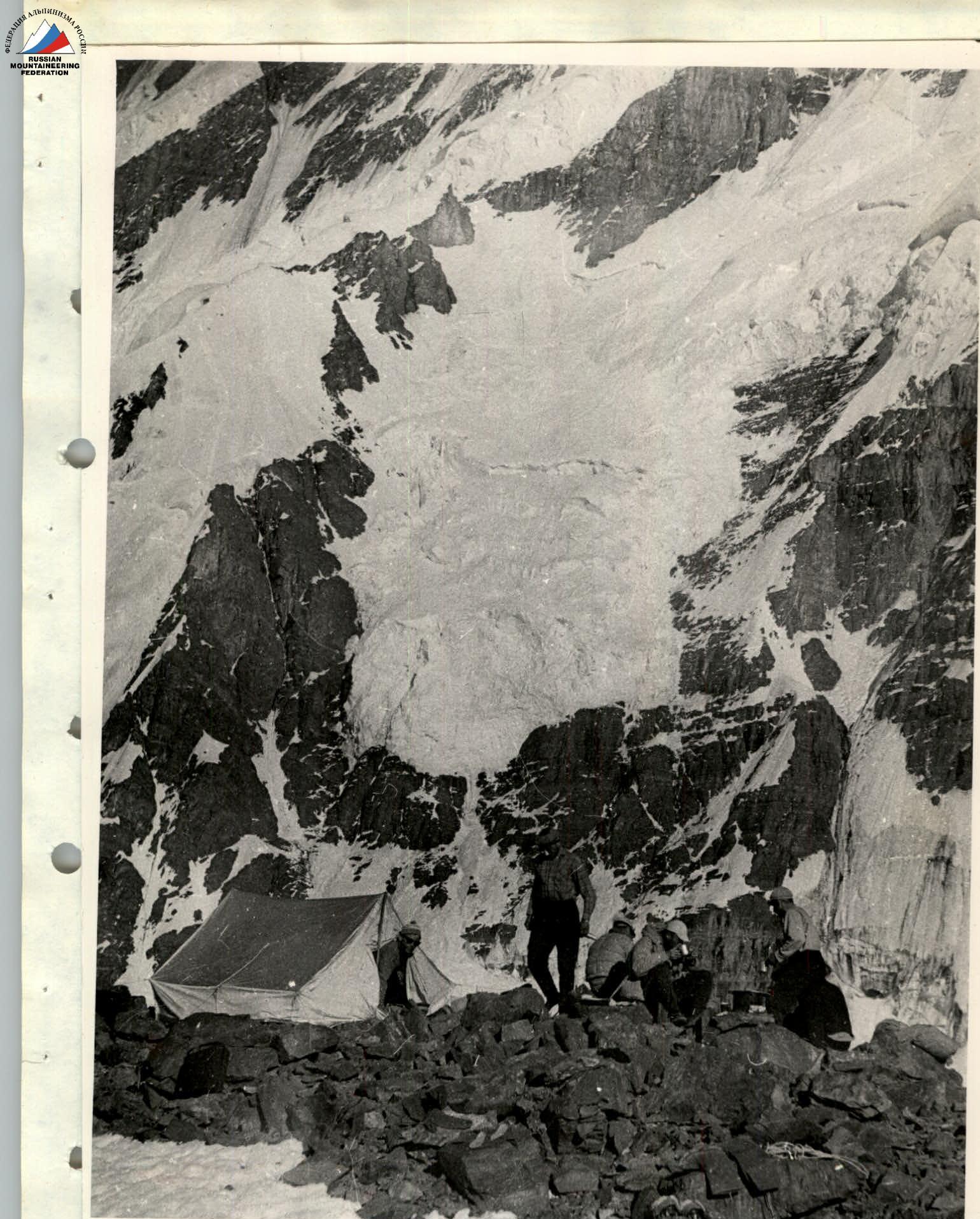
Before reaching the ridge, they set up an overnight platform. (See photo 1. Bivouac)
August 5, 1969.
Departure at 7:00 AM. They traverse the ridge, which drops off steeply on both sides with overhanging snow caps, then along smoothed slabs covered with a thin layer of ice (100 m), and reach the foot of an icefall. They move left along rocky ledges 3–4 m wide, still covered in ice, with an ice wall on the right and a sheer drop on the left down to the Belyaev Glacier. After 100 meters of movement, they turn 90° and make a diagonal ascent up a steep ice slope onto a snow field of a hanging glacier. Steps are cut. Protection is provided by pitons: rock pitons at the bottom and ice screws when exiting onto the ice. Then, they traverse 500 meters of a steep firn slope. In places, they have to cross crevasses via bridges or bypass them on the right. The snow is unstable; two rows of ice falls are traversed. Steps are cut, and protection is provided by pitons. They turn left towards the rocks and find a spot for a tent on the snow before reaching them. At 21:30, a green flare is raised in response to theirs. (See photo 2. Bivouac)
August 6, 1969.
The weather in the morning is good, as on the previous days. The entire day is spent overcoming rocks. The steepness starts at 45°, then increases to 50–55°. In places, there are steeper sections. They approach the famous 30-meter rock tower. Having overcome it, they reach a steep ridge (70°), which leads to the shoulder at 6900 m. They set up an overnight stay on a convenient snow platform. An icy wind restricts movement. (See photo 3. Bivouac)
August 7, 1969.
The wind remains strong. They traverse the ridge with a slight ascent, then make a traverse of a snow slope to the left. Feet sink deeply into loose snow; occasionally, there are dense snow "boards". Further, they ascend a snow slope with a steepness of 45° containing very loose snow. After 450 meters, they reach a snow-ice ridge. They set up a tent on the snow between protruding rocks and fall asleep until morning. The altitude is 7200 m. (See photo 4. Bivouac)
August 8, 1969.
Departing at 10:00 AM, they overcome the last few hundred meters along the ridge and reach the summit at 13:00. They enjoy the view, and examine the banners left by the Chelyabinsk teams, then begin their descent to the south. Having descended to an altitude of 6800 m, they set up a tent. (See photo 5. Bivouac)
August 9, 1969.
They begin their descent at 8:00. They quickly descend to the broken part of the glacier. Here, the pace slows somewhat. Having rappelled down an ice wall, they reach a plateau and move along it, bypassing Peak Pravdy. At the start of the next descent, they set up an overnight stay.
August 10, 1969.
At 6:00 AM, they begin a difficult descent through the icefall, which is over 1000 m long. The great steepness of the section and exposed ice require the use of pitons. The descent is carried out using a sport climbing technique for 250 m, then with protection via an ice axe. At 14:00, the group reaches the camp on the Belyaev Glacier.
On the same day, the entire expedition team begins their descent to the Garmo Glacier, and on August 11, the groups arrive at the base camp.
VII. Evaluation of the group's actions
All group members have many years of experience in joint ascents, which positively impacted their performance on the route. Each participant has a good command of the entire range of techniques for traversing rocky, icy, and snowy sections.
Good training and excellent acclimatization of the participants ensured the success of the ascent; all climbers felt great on the route.
Movement was carried out in two teams – of two and three people. The composition of the teams changed daily, and each participant worked in all the links.
The route is classified as category 6B and fully deserves this classification.

TABLE OF MAIN CHARACTERISTICS OF THE ASCENT ROUTE
- Altitude difference along the route: 7495 m – 4600 m = 2895 m
- Including difficult sections – 550 m
- Route steepness: average – 45°, including complex sections – 60–90°

| Date | Sections traversed | Average steepness of sections (in degrees) | Length of sections | Character of relief | Difficulty (by technique) | Method of advancement and protection | Weather conditions | Time of bivouac setup | Time of departure | Rock pitons used | Ice screws used | Shлямбуров used | Conditions of overnight stay |
|---|---|---|---|---|---|---|---|---|---|---|---|---|---|
| August 4 | R0–R1 | 5–10 | 1000 m | Open glacier | easy | simultaneously | clear sky, no wind | 6:00 | |||||
| R1–R2 | 5 | 200 m | Closed glacier, crevasses | easy | simultaneously | ||||||||
| R2–R3 | 45 | 300 m | Snow-ice slope | medium | crampons, simultaneously | ||||||||
| R3–R4 | 45–55 | 250 m | Broken rocks, rocky ledges, many "live" stones | medium | pitons, outcrops | 6 | |||||||
| R4–R5 | 60–40 | 200 m | Rocks leading to a ridge with cornices on both sides | medium | 2 | ||||||||
| R5–R6 | 20 m | Smooth sheer slab 10 m, followed by a sharp ice ridge | medium | rappel, pitons | 2 | ||||||||
| R6–R7 | 40 | 250 m | Snow-ice slope | medium | alternately | 17:30 | 21:20 | Platform made on an ice slope. Excellent. | |||||
| August 5 | R7–R8 | 10 | 150 m | Ridge dropping off steeply on both sides, cornices on both sides | medium | outcrops | 7:00 | ||||||
| R8–R9 | 40 | 100 m | Smoothed slabs with large crevasses | medium | pitons | 5 | |||||||
| R9–R10 | 25 | 100 m | Rocks smoothed by ice, 3–4 m wide. Bypass of a hanging glacier | medium | 5 | 2 | |||||||
| R10–R11 | 60–65 | 50 m | Ice | difficult | steps, crampons, pitons | 5 | |||||||
| R11–R12 | 30–50 | 500 m | Ice covered with snow. местами чистый. Crevasses, bergschrunds | medium | ice axe, pitons | 8 | |||||||
| R12–R13 | 15 | 100 m | Traverse left across snow onto rocks. Bergschrund | medium | Ice axe | 17:20 | 10:20 | Platform under a rocky overhang on snow. Good. | |||||
| August 6 | R13–R14 | 45 | 200 m | Broken rocks, partially covered with snow | medium | pitons | clear sky, wind | 7:30 | 10 | ||||
| R14–R15 | 50 | 320 m | Rocks | difficult | pitons | 24 | |||||||
| R15–R16 | 50–70 | 200 m | Rocks | very difficult | pitons | 22 | 3 | in rocks | |||||
| R16–R17 | 45 | 40 m | Snow | easy | Ice axe | strong wind | 21:00 | 13:30 | On snow. Excellent. | ||||
| August 7 | R17–R18 | 150 m | Snow ridge | medium | simultaneously | clear sky, wind | 9:00 | ||||||
| R18–R19 | 35 | 60 m | Snow ridge | medium | |||||||||
| R19–R20 | 0–45 | 80 m | Traverse of a snow slope. Loose snow, sometimes snow "boards" | easy | Ice axe, physical effort | wind | On a rocky slab. Excellent. | ||||||
| R20–R21 | 45 | 450 m | Snow slope, partially loose snow | medium | in 3 teams, Ice axe | 18:00 | 9:00 | ||||||
| August 8 | R22–R23 | 20 | 200 m | Snow-ice ridge | medium | clear sky | reached the summit at 13:00 |
Total on ascent:
- rock pitons used – 76
- ice screws used – 18
During descent:
- rock pitons used – 3
- ice screws used – 12
Chairman of the Regional Physical Culture Committee – (V. Sokolov) Leader of the ascent – (V. Sibiryakov)