Ascent Log
- Ascent category — High-altitude
- Ascent area — Central Pamir, Bivachny Glacier
- Ascent route with peak names and elevations — East ridge of Peak Kommunizma, 7495 m
- Ascent description: height difference 2895 m, average slope 40°, complex section length — 277 m
- Number of pitons used: rock — 23, ice — none, bolted — none
- Total climbing hours — 28 h 30 min
- Number of bivouacs and their description — six: during ascent — on 4600 m № 1, on 5900 m № 2, on 6400 m № 3, on 6900 m № 4; during descent — on 6900 m № 4, on 5600 m № 5. All bivouacs were lying down and comfortable.
- Team name — Armed Forces of the USSR (SKA KSAVO)
- Surname, name, patronymic of the leader, participants, and their qualification: Popenko Yuri Stepanovich, CMS; Belovol Evgeny Vasilyevich, CMS; Staroseltsev Evgeny Vasilyevich, MS; Afanasyev Vladimir Mikhailovich, CMS; Kuramshin Rashit Midhatovich, CMS.
- Team coach — Ilyinsky Ervand Tikhonovich, MS, Honored Coach of the Kazakh SSR.
- Date of departure and return — August 20, 1975; August 25, 1975.

- Peak Kommunizma from the east (taken from Peak Revolyutsionerov) Routes: 1 — Tatma's path (August 13, 1961); 2 — Kchetsky's path (September 2, 1967); 3 — Budanov's path (August 21, 1968); 4 — E. Abalakov's path (September 3, 1933); 5 — Voronin's path (August 19, 1970); 6 — Sapozhnikov's path (August 19, 1971).
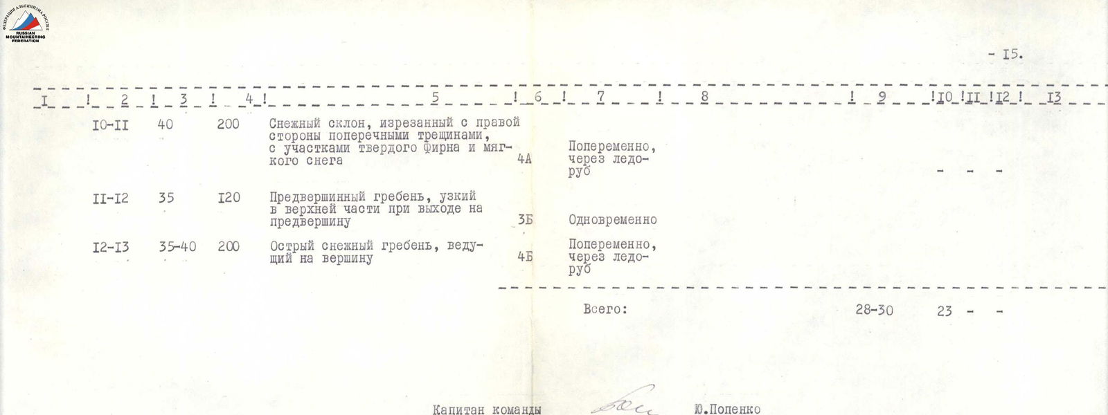 Photo 2. East ridge of Peak Kommunizma.
1. Description of the Ascent Area
Detailed study of the Peak Kommunizma area began in the late 1920s by Soviet researchers and scientists.
In 1928, a Soviet-German expedition worked in the Pamir mountains, which first measured the height of Peak Kommunizma — 7495 m, but mistakenly identified it as Peak Garmo.
In 1932, climbers and topographers established that the peak "7495" rises at the junction of the Peter the First and Academy of Sciences ranges, 18 km north of Peak Garmo. At the suggestion of N. V. Krylenko, the 7495 m peak was named Peak Stalin, and in 1960 it was renamed Peak Kommunizma.
In 1933, a special team № 29 was included in the Tajik-Pamir expedition, tasked with conquering Peak Kommunizma from the Bivachny Glacier via the eastern ridge. After lengthy and thorough route preparation, on September 3, Evgeny Abalakov successfully reached the summit.
In 1955, climbers from the Georgian Alpine Club ascended to the summit from the Belyaev Glacier.
From 1957 onwards, groups of climbers ascended Peak Kommunizma via various routes almost annually (photo 1). The number of routes now totals around two dozen. Several routes are rated as the highest 6th category of difficulty.
The climate of the Peak Kommunizma area is characterized by exceptional dryness and harshness. At the Fedchenko Glacier meteorological station (4169 m), the average July temperature is minus 8 °C, and the average January temperature is minus 31.4 °C.
The average annual precipitation on the Fedchenko Glacier is around 1100 mm. Due to the sharp continental climate, the snow line in the Peak Kommunizma area is at an altitude of 4400 m.
The Academy of Sciences range is composed of Paleozoic metamorphic and sedimentary strata (phyllites and other metamorphic schists, quartzites, marbles, limestones), which are penetrated by magmatic intrusive rocks (granites, granodiorites).
The relief of the area is characterized by deep, steeply sloping valleys with bare rocks and large scree slopes on their slopes. The ridges are sharp, with typical alpine-glacial relief, and sharp peaks.
Earthquakes, intense processes of thermal and frost weathering, combined with a large height difference and steep slopes, make the relief very dynamic. Rockfalls, live scree, snow avalanches, ice collapses, unexpected and sudden glacier movements, and the dissected and inaccessible nature of the ridges pose serious obstacles on the path to the summits.
2. Pre-Ascent Preparation
2.1. Route Selection
The choice of ascent route was determined by two factors:
— 1. The greatest logic, purposefulness, and sufficient technical and tactical complexity of the East ridge of Peak Kommunizma among all possible routes from the Bivachny Glacier.
— 2. The desire to pay tribute to the pioneer of this route, Soviet climber Evgeny Mikhailovich Abalakov, by following his path (photos 1, 2).
The final choice was made upon arrival in the ascent area. Before heading to the mountains, the team thoroughly familiarized themselves with all routes taken to Peak Kommunizma from this side, weather conditions, and the specifics of the ice-rock relief.
2.2. Tactical Ascent Plan
Having decided on the ascent route to Peak Kommunizma, the team proceeded to prepare for it. A tactical ascent plan was drawn up, the main milestones of which were as follows:
— 1. Ascent to the East ridge for acclimatization and delivery of equipment and supplies to an altitude of 6000 m with a bivouac at 5600 m.
— 2. Acclimatization ascent to the summit in the base camp area with a bivouac at an altitude of around 6000 m.
- Ascent to Peak Kommunizma with intermediate camps at altitudes of 4600 m, 5600 m, 5900 m, 6400 m, and 6900 m.
More details of the tactical plan are provided in the ascent debriefing report (appendix 5).
- Descent to the base camp — two days.
From August 8, the team began implementing the planned plan. The first intermediate camp at 4600 m was set up on August 9 under the slopes of Peak Ordzhonikidze as a support base for the assault on Peak Kommunizma. Over the next two days, August 10 and 11, the path to the ridge was reconnoitered through the icefall, a camp was set up at 5600 m, and equipment and supplies were delivered to altitudes of 5900 m and 6200 m.
During the same sortie, a site was prepared at 5900 m for a bivouac.
Equipment delivered to the ridge included pitons, ropes, a tent, and some personal gear.
On August 12, the team returned to the base camp, and on August 14, for additional acclimatization, the team ascended Peak Revolyutsionerov (~6000 m), where they spent the night at the summit. On August 16, they descended to the base camp to rest.
On August 19, the team departed for camp 4600 m to begin the ascent to Peak Kommunizma. From camp 4600 m, with favorable weather, the team began their journey to the summit. Excellent physical preparation of the participants allowed them to ascend directly to the 5900 m bivouac, bypassing the 5600 m bivouac. This saved one day on the ascent to Peak Kommunizma. Having passed all the planned camps, the team reached the summit on August 23 and descended to the base camp on August 25. During the descent, they spent a night at 6900 m and another at 5600 m before descending the icefall. Thus, the developed tactical plan was followed fairly strictly during the ascent.
To ensure safety on the route, the tactical plan included:
— 1. Passing the lower icefall in the morning hours when the likelihood of it falling is lowest.
— 2. Passing complex and hazardous sections of the route with alternate piton protection or protection through ledges.
- On hazardous snow slopes, all participants were lowered down on fixed ropes. The last person descended with bottom protection.
2.3. Ascent Organization
To ensure safety measures during the ascent, the following steps were taken:
— 1. Organization of three groups with a total of 15 people to interact with the team making the qualifying ascent to Peak Kommunizma. These groups departed with a one-day interval between them and our team.
— 2. Establishment of constant observation of the team from a point under the slopes of Peak Ordzhonikidze by two observers using 40x binoculars.
— 3. Ensuring reliable radio communication between the support groups, the base camp, and the base camp with Darout-Kuran. The communication scheme looked as follows:

— 4. Equipping the team with modern group and personal gear (appendices 8 and 9) and high-calorie food (appendix 10).
— 5. Ensuring thorough medical monitoring of the participants and equipping the team with a necessary set of medications.
3. Ascent Conditions
Overall, the ascent conditions were favorable. Periodically, fog rolled in, and snow fell in small portions, but after the Tien Shan bad weather, this was not particularly felt. Only on the day of the ascent was there a strong wind with drifting snow, which filled goggles and stung faces, under an absolutely clear, blue sky. However, by 14:00, the wind had died down, allowing the team to enjoy a good panorama from the summit of Peak Kommunizma.
The route in the lower part is snow-rock. Rock "gendarmeres" alternate with sections of snow ridges. This continues up to an altitude of 6400 m.
Further, the route is purely snowy with individual sections of hard firn. Snow slopes sometimes give way to sharp, steep ridges. Movement here is mostly simultaneous, but in some cases, it is alternate with protection through an ice axe.
The daily altitude gain was between 500 and 1300 m.
The largest altitude gain was on the first day of ascent: 1300 m from 4600 m to 5900 m. In subsequent days, it remained at around 500 m, including on the day of reaching the summit (7495 m) from 6900 m.
4. Team Composition
Popenko Yu. S., Captain, CMS
Belovol E. V., Deputy Captain, CMS
Staroseltsev E. V., Participant, MS
Afanasyev V. M., Participant, CMS
Kuramshin R. M., Participant, CMS
The quantitative composition of 5 people was determined by the reasons specified in the ascent debriefing report (appendix 5).
All ascent participants know each other well, having shared ascents and participated in alpine events together.
Four out of five have already climbed seven-thousanders, so they have high-altitude climbing experience.
The team trains systematically under the guidance of Master of Sports, Honored Coach of the Kazakh SSR Ilyinsky E. T.
5. Evaluation of Participants' and Team's Actions
Team Captain: "Team members worked conscientiously, dedicating all their efforts to achieving the set goal — conquering the highest peak in the Soviet Union".
"Particularly noteworthy was the active work of V. Afanasyev at altitudes above 7000 m, who led the way for most of the route".
Team Coach: "The team successfully accomplished the task — ascending Peak Kommunizma to gain high-altitude climbing experience. The ascent was made at a good pace, indicating the high physical fitness of the participants and correct planning of the ascent considering their capabilities. The team did not violate safety requirements during the route".
Team Captain Yu. Popenko Team Coach E. Ilyinsky
6. Description of Route Passage
August 19. At 11:00, the team departed from the base camp located at an altitude of 3700 m on the right side of the Bivachny Glacier. Following a trail upstream along the slope to a glacial lake, they crossed the Bivachny Glacier towards the confluence with the Stalin Glacier. They then rounded a pinch on the left and followed a trail along the slope upwards to the next pinch. Again, they exited onto the glacier and continued along the seracs towards the foot of the East ridge of Peak Kommunizma.
At the confluence of the Stalin Glacier and Peak Ordzhonikidze, not reaching the ice ascents, they crossed the Stalin Glacier to the right towards the southern slopes of Peak Ordzhonikidze, where they set up the first intermediate camp at 4600 m. The approach took 5 h 30 min.
August 20. The team departed early at 7:00. Immediately from the 4600 m camp, they had to navigate through a band of seracs to reach the start of the route. After the seracs, the path went briefly along the bed of a glacial stream (upstream), then turned sharply left and began ascending the first ascent of the glacier flowing from the slopes of Peak Kommunizma (section R0–R1). The steepness of the ascent, which was 30° at the bottom, increased to 40° as they climbed. The path was obstructed by longitudinal crevasses at the bottom and transverse crevasses at the top, where the glacier bent. The glacier then became less steep. However, a second ice ascent followed, also with a steepness of 35–40° (section R0–R1), leading under a hanging icefall. Under this icefall, they moved left and upwards onto an ice field, bypassing a lower active icefall adjacent to the rocks of the East ridge. The ice field on the right gave way to an ice slope with a steepness of 35–40° (section R0–R1), which led into an ice corridor cut by transverse crevasses. From the ice corridor, they ascended a 50° left slope with step-cutting to the right and upwards, emerging onto an ice slope adjacent to the rocks of the East ridge. Movement continued left and upwards along the boundary between rocks and ice in an ice gully with a steepness of 40°, from which they deviated right onto a rock-ice slope of the same steepness, transitioning into a purely rock slope with heavily weathered rocks (section R0–R1). The slope led them to the East ridge to the 5600 m camp (photo 3). The ascent from the 4600 m camp to 5600 m took 4 hours. After a 2-hour rest, they packed their gear and continued their ascent towards the 5900 m camp at 13:00. Initially, the path went gently upwards over snow covering scree, then descended slightly (section R1–R2, photo 3). A total descent of 100 m. Further, the path followed the ridge with rock outcrops (15 m), dropping steeply to the right with an ice slope and to the left with a 40° rock slab (section R1–R2).
From the ridge, they deviated left onto slabs with heavily weathered rocks. Movement along the ridge and slabs was with alternate protection, including 80 m along the slabs at an angle of 30° (section R1–R2). After the slabs, they returned to the ridge and continued their ascent along the right snow slope of the ridge (section R1–R2) with a steepness of 35–40° simultaneously (120 m).
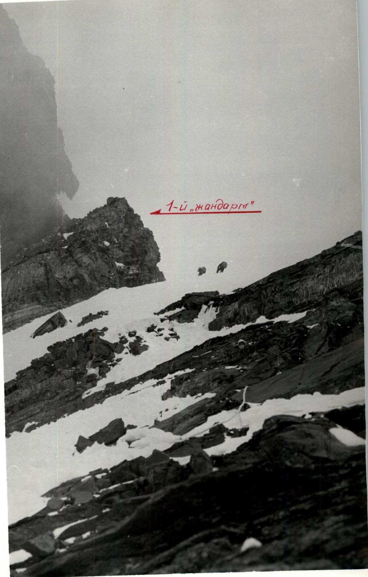
Not reaching the first "gendarme" (photo 4), the ridge became steeper at 50° over a 10-meter section with exposed ice. These 10 m were traversed with step-cutting and alternate protection. Further, the ridge leading to the first "gendarme" had a steepness of 45°. The "gendarme" was bypassed on the right along a 40 m rock slab of moderate difficulty with a steepness of 45° (section R2–R3, photo 5). The rocks on this section had a tile-like structure.
After the first "Gendarme", movement continued along the snow ridge (80 m) with a steepness of 40° (section R3–R4). Before approaching the second "gendarme", the ridge steepness increased to 50° over a 30 m section (section R3–R4). The ascent to the second "gendarme" began with a steep 4-meter rock wall composed of brittle shale plates (section R4–R5). Above the wall, they traversed left along a wide ledge for 5 m, then ascended 30 m along a 50° slab also composed of shale (section R4–R5). Above the "gendarme", they set up a bivouac at 5900 m on the ridge before a rock "boulder".
The ascent from the 5600 m bivouac to 5900 m took 2 h 30 min, and setting up the bivouac took 2 hours.
The weather throughout the day was poor: fog in the morning, snow in the second half of the day, and snow with strong winds by evening.
August 21. The first pair, E. Belovol and V. Afanasyev, started on the route at 9:00. Initially, they ascended to the "boulder" of the second "gendarme", bypassing it on the left along a ledge, and then climbed the snow ridge (section R5–R6, photo 6) with a steepness of 45° (60 m) towards the third "gendarme", which was traversed head-on along heavily weathered shale rocks (photo 7).
The length of the rocks on the third "gendarme" was 40 m, and the steepness varied from 50° at the bottom to 40° at the top (section R5–R6). From the third "gendarme" to the fourth, the path followed the left side of a rocky, heavily weathered ridge (15 m) with a steepness of 40° (section R5–R6).
The fourth "gendarme" was bypassed on the right along a stepped slab (40 m) also composed of plate-like shale. The slab's steepness was 45° (section R5–R6).
They then returned to the ice-snow ridge with a steepness of 40°, which after 40 m abutted against the fifth "gendarme" (section R5–R6). Overcoming it began with a steep 70° 3-meter wall (section R6–R7), above which they deviated left and upwards along an inclined ledge (photo 8), bypassing a rock outcrop and then emerging onto an ice-snow slope with a steepness of 40° (section R6–R7). Along this slope, after 15 m, they encountered a 5-meter steep wall (70°), which was traversed head-on, leading to a 7-meter inclined ledge (section R6–R7). Moving along the ledge, they entered an ice-rock gully with a steepness of 50° and a length of 20 m on the left side of the fifth "gendarme" (section R6–R7). The gully ended in an inclined shelf, from which a snowslope extended upwards with the same steepness as the gully (section R6–R7). The snowslope led to a snow ridge with rock outcrops. Along this ridge with a steepness of 40°, they moved 40 m towards the sixth "gendarme" (section R6–R7). Not reaching the "gendarme" by one rope length (40 m), they deviated right in traverse and then ascended a rocky slope with a steepness of 45°, covered in snow (240 m), to the ridge above the sixth "gendarme" (section R6–R7). Along the ridge with a steepness of 35°, they reached the 6400 m bivouac at 17:00.
A suitable site on a rocky ridge, prepared by previous climbers from slate slabs, was used to set up the tent.
The weather throughout the day was poor: strong winds with snowfall. Only by 18:00 did the snowfall cease, but it became very cold.
August 22. The team departed from the bivouac at 10:00. Initially, the path continued (40 m) along a gently sloping rocky ridge (section R7–R8), which then transitioned into a snow ridge and, gradually widening, became a snow slope about 1 km long with two snow "cushions" (section R7–R8).
On the upper "cushion" at 14:00, they set up the 6900 m camp.
The weather was magnificent: warm and windless. However, this had a negative side — the snow became very soft, making movement difficult.
Having achieved the goal set by the tactical plan — reaching 6900 m — they considered further ascent under the prevailing conditions to be impractical.
August 23. The team departed for the ascent at 7:00. The sky was cloudless, but a strong side wind carried drifting snow. Initially, they moved (400 m) along a gently sloping slope (20°) of the second snow "cushion" (section R8–R9), after which they encountered a steep 40–50° snow ridge (section R9–R10), sharp at the top and resembling a sickle in shape (100 m). The ridge then gave way to a gentle (20°) slope (section R9–R10), which after 160 m led to a snow slope cut by transverse crevasses on the right side, with a steepness of 40° (section R10–R11). Characteristic of this slope was the alternation of sections of hard firn and soft snow. Along this slope (section R10–R11), they ascended 200 m to reach the pre-summit ridge with a steepness of 35°, which, narrowing at the top, led after 120 m to the pre-summit (section R11–R12). From the pre-summit to the summit, the path (200 m) followed a sharp snow ridge (section R12–R13) with a steepness of 30–40°. Movement was with alternate protection through ice axes.
At 17:00, the team reached the summit, where they retrieved a note left by the group of V. Lukin on August 1, who had completed a traverse of Peaks Kommunizma and Korzhenevskaya. By 21:00, all participants had descended to the 6900 m tent.
The weather was windy and cold in the morning, improving after 13:00. They spent half an hour on the summit, examining and photographing the panorama of surrounding peaks.
August 24–25.
Over the next two days, the team descended to the base camp at 3700 m, with an intermediate bivouac at 5600 m to ensure backup for groups on the ascent.
The weather during the descent was more favorable than during the ascent.
Photo 3. Ridge with "gendarme". Sections R2–R7. Tent — cache at 5600 m.
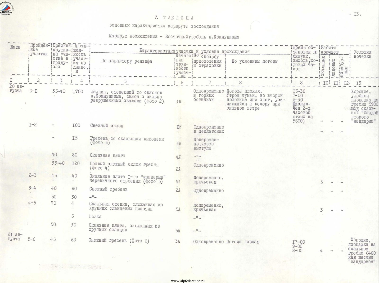
Photo 4. Approach to the 1st "gendarme".
7. Table of Main Ascent Route Characteristics
Ascent route — East ridge of Peak Kommunizma
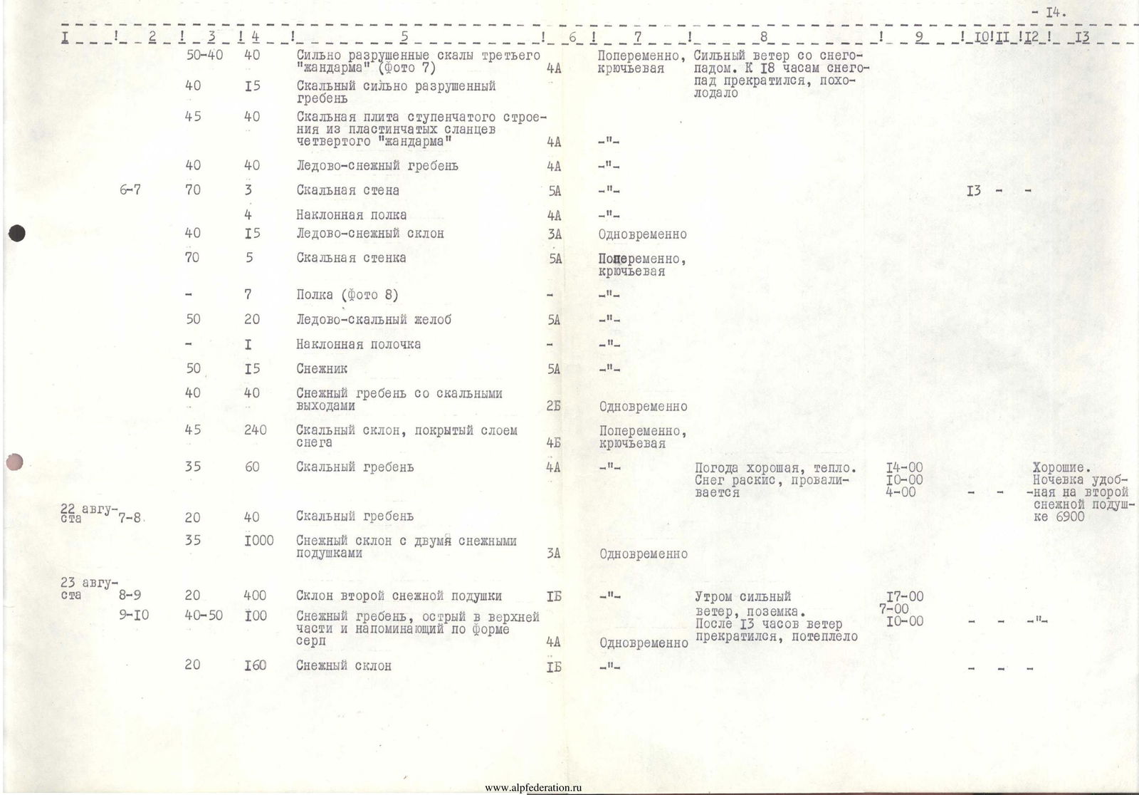
| Date | Sections traversed | Average steepness of section in degrees | Section length, m | Section description and passage conditions | Section difficulty category | Method of overcoming and protection | Weather conditions | Time of bivouac, departure, climbing hours | Rock pitons used | Ice pitons used | Bolted pitons used | Bivouac conditions |
|---|---|---|---|---|---|---|---|---|---|---|---|---|
| August 20 | R0–R1 | 35–40° | 1700 | Glacier flowing from the slopes of Peak Kommunizma, slope with heavily weathered rocks (photo 2) | 3Б | Simultaneously in crampons | Poor weather. Fog in the morning, snow in the second half of the day, intensifying by evening with strong winds | 15:30 7:00 6 h 30 min (excluding 2-hour rest at 5600 m) | Good, convenient site on the ridge at 5900 m under the rock "boulder" of the second "gendarme" | |||
| R1–R2 | 100 | Snow slope | 1Б | Simultaneously in wicketons | ||||||||
| 15 | Ridge with rock outcrops (photo 3) | 3Б | Alternately, through ledges | |||||||||
| 80 | Rock slab | 4 | ||||||||||
| 35–40° | 120 | Right snow slope of the ridge (photo 4) | 2А | Simultaneously | ||||||||
| R2–R3 | 45° | 40 | Rock slab of the 1st "gendarme" with a tile-like structure (photo 5) | 4А | Alternately, with piton protection | 3 | ||||||
| R3–R4 | 40° | 80 | Snow ridge | 2А | Simultaneously | |||||||
| 50° | 30 | |||||||||||
| R4–R5 | 70° | 4 | Rock wall composed of brittle shale plates | 5А | Alternately, with piton protection | 3 | ||||||
| 5 | Ledge | |||||||||||
| 50° | 30 | Rock slab composed of brittle shale | 5А | |||||||||
| August 21 | R5–R6 | 45° | 60 | Snow ridge (photo 6) | 3А | Simultaneously | Poor weather | 17:00 9:00 8 h 00 min | Good, site on a rocky ridge at 6400 m above the sixth "gendarme" | |||
| R5–R6 (part) | 50–40° | 40 | Heavily weathered rocks of the third "gendarme" (photo 7) | 4А | Alternately, with piton protection | Strong winds with snowfall. Snowfall ceased by 18:00, became very cold | ||||||
| 40° | 15 | Rocky, heavily weathered ridge | ||||||||||
| 45° | 40 | Stepped rock slab of the fourth "gendarme" composed of plate-like shale | 4А | |||||||||
| 40° | 40 | Ice-snow ridge | 4А | |||||||||
| R6–R7 | 70° | 3 | Rock wall | 5А | ||||||||
| 4 | Inclined ledge | 4А | ||||||||||
| 40° | 15 | Ice-snow slope | 3А | Simultaneously | ||||||||
| 70° | 5 | Rock wall | 5А | Alternately, with piton protection | ||||||||
| 7 | Ledge (photo 8) | |||||||||||
| 50° | 20 | Ice-rock gully | 5А | |||||||||
| 1 | Inclined shelf | |||||||||||
| 50° | 15 | Snow slope | 5А | |||||||||
| 40° | 40 | Snow ridge with rock outcrops | 2Б | Simultaneously | ||||||||
| 45° | 240 | Rocky slope covered in snow | 4Б | Alternately, with piton protection | ||||||||
| 35° | 60 | Rocky ridge | 4А | Good weather, warm. Snow is soft, collapses | 14:00 10:00 4 h 00 min | Good. Comfortable bivouac on the second snow "cushion" at 6900 m | ||||||
| August 22 | R7–R8 | 20° | 40 | Rocky ridge | ||||||||
| 35° | 1000 | Snow slope with two snow "cushions" | 3А | Simultaneously | ||||||||
| August 23 | R8–R9 | 20° | 400 | Slope of the second snow "cushion" | 1Б | Strong winds, drifting snow in the morning. Wind ceased after 13:00, warmed up | 17:00 7:00 10 h 00 min | |||||
| R9–R10 | 40–50° | 100 | Snow ridge, sharp at the top and resembling a sickle in shape | 4А | Simultaneously | |||||||
| 20° | 160 | Snow slope | 1Б | |||||||||
| R10–R11 | 40° | 200 | Snow slope cut by transverse crevasses, with sections of hard firn and soft snow | 4А | Alternately, through ice axe | |||||||
| R11–R12 | 35° | 120 | Pre-summit ridge, narrow at the top, leading to the pre-summit | 3Б | Simultaneously | |||||||
| R12–R13 | 35–40° | 200 | Sharp snow ridge leading to the summit | 4Б | Alternately, through ice axe | |||||||
| Total: | 28–30 h | 23 |
Note: In the columns "Rock pitons used", "Ice pitons used", and "Bolted pitons used", the number of pitons is given for the section as a whole.
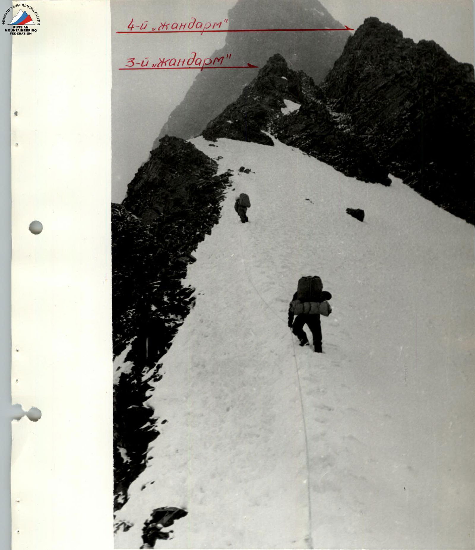
Photo 6. Approach to the 3rd "gendarme".
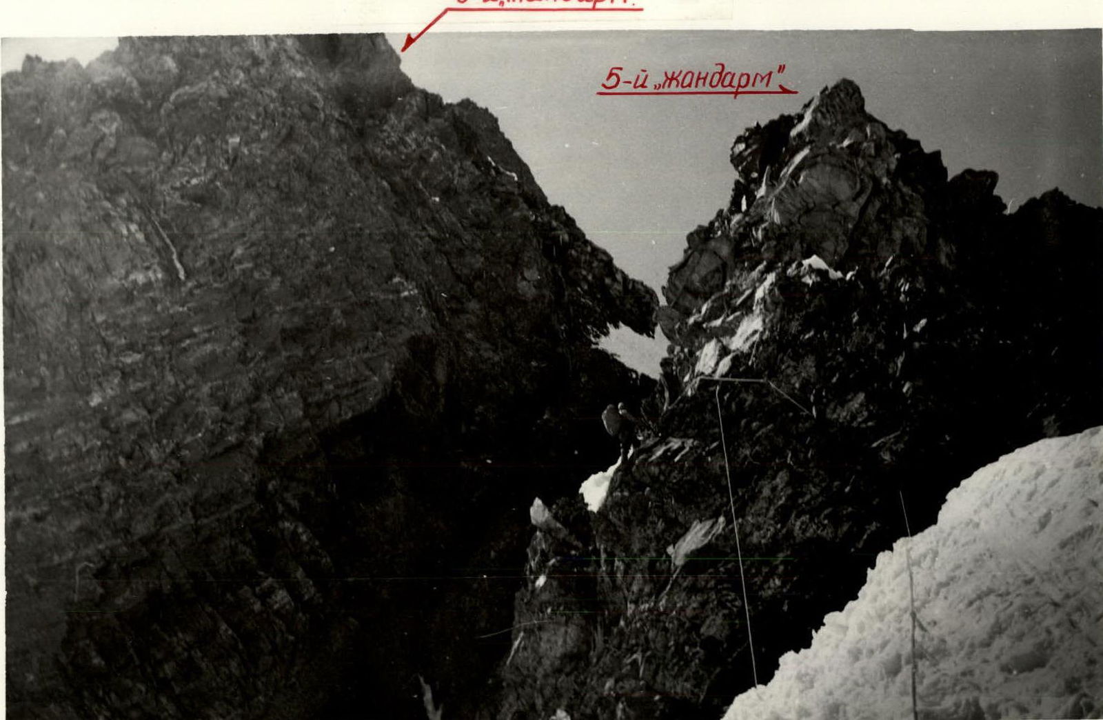
Photo 8. Bypass of the 5th "gendarme" along the ledge.