I. High-altitude class.
- Pamir. Akademiya Nauk Range.
- Peak Kommunizma, 7495 m, via the northern route through p. 6950 m (Borodkin)
- Difficulty category — 5A
- Elevation gain: 3300 m
average slope of the route 40°
section lengths:
- R2 — 1200 m
- R3 — 4000 m
- R4 — 600 m
- R5 — 100 m
- Pitons driven:
rock 5, bolt 0, chock 0, ice 8
- Team's working hours: 292 hours.
- Overnights: 3 overnights — bivouac.
- Team leader: Team members:
Valeriy Alekseyevich Kolyshkin — Master of Sports Aleksandr Filippovich Savchenko — Candidate for Master of Sports Yuriy Anatol'yevich Dumik — Candidate for Master of Sports Sergey Alekseyevich Kozhushko — Candidate for Master of Sports
- Coach: Aleksandr Dmitriyevich Tsymbal.
- Departure to the route — August 8, 1984, summit — August 10, 1984, return — August 11, 1984.
Our team members, all graduates of the Taganrog Radio Engineering Institute, had experience climbing routes of the highest difficulty category in various mountainous regions of the USSR in previous sports seasons, and repeatedly participated in the USSR, RSFSR, and Caucasus alpine championships. In 1982, participating in the CS "Burevestnik" primacy in the technical class, the team took 1st place for the ascent to v. Zindon via the center of the North wall, 6B category of complexity (Shumilov's route).
The team began preparing to participate in the RSFSR primacy in the high-altitude class in January 1984. The intended object of ascent was p. Pobedy. As preparation, a two-week training camp was held in Prielbrusye at the "Mir" station (3500 m). During the spring period, they trained on rocks and participated in various rock climbing competitions. They took part in the Rostov-Taganrog run, which was dedicated to the memory of deceased climbers. In May, a training trip to the Crimea rocks was organized.
As a result of regular training and alpine events, the team members were in good physical shape by the start of the season. But due to various reasons, the object of ascent had to be changed at the last moment: instead of p. Pobedy, p. Kommunizma was chosen. Due to a lack of time, it was not possible to thoroughly study the routes on p. Kommunizma; the route of D. Borodkin was chosen, which, as it turned out later, was downgraded to 5A category of complexity.
Before the championship, a training camp was held in the Tian Shan in the Karakol gorge. In bad weather, the Ryabukhin route was climbed on the Dzhigit peak via the North wall, 5B category of complexity. In addition, as part of preparations for the competition, already in the Pamir, the team made an ascent to p. E. Korzhenevskoy.
Due to the expedition's base being located under p. Lenin, the team was tied to the schedule of the MAL helicopter, which was supposed to take us back. Due to time constraints, we had to abandon the backup option — p. Korzhenevskoy via the South wall, 5B category of complexity (Dobrovolskiy's route), although after the "demotion" of D. Borodkin's route on p. Kommunizma, an ascent to p. E. Korzhenevskoy would have been preferable.
Having a description of the route and consultations with groups that had passed this route, we drew up a tactical plan for the ascent.
Ascent schedule.
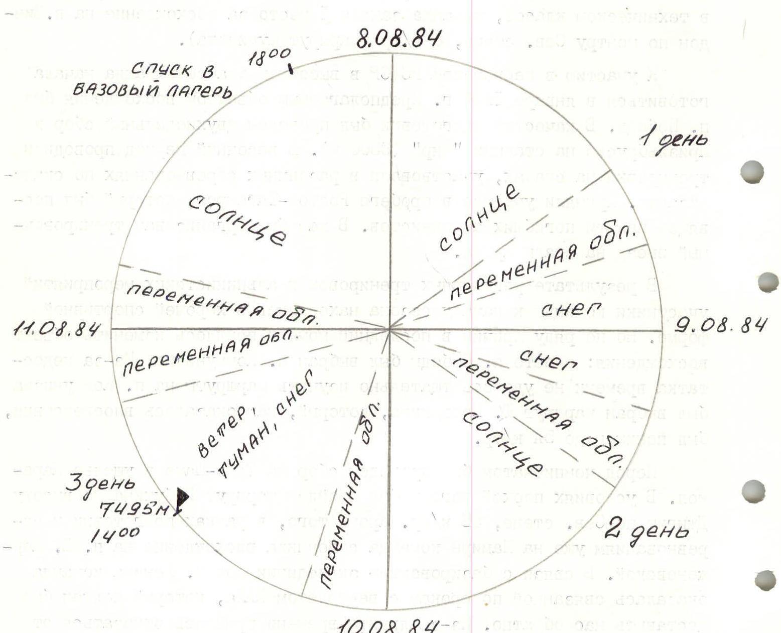
Due to the team's good preparation and successful acclimatization during the ascent to p. Korzhenevskoy, the tactical plan was to complete the ascent in a short time. The weather was not favorable for the ascent — it was not very stable, sunshine alternated with fog and clouds, fresh snow fell, hindering the team's progress.
The tactical plan for the ascent looked as follows:
- 1st day — ascent from the base camp to 5300 m
- 2nd day — ascent to "Verblud" and descent to the 6000 m plateau
- 3rd day — ascent to the shoulder of p. Kommunizma 6900 m
- 4th day — exit to the summit and descent to 6500 m
- 5th day — descent to the base camp
The team left the base camp on August 8, 1984. Heavy rain forced them to stop for the night before the Walter Glacier. Bad weather made adjustments to the tactical plan. It was decided to leave the next day and get back on schedule. On August 9, 1984, the team ascended to "Verblud" and descended to the plateau of p. Kommunizma. Fresh snow fell during the night. Fog and lack of visibility did not allow them to leave the bivouac early. Fresh snow greatly hindered progress. Because of this, they deviated from the tactical plan and stopped for a bivouac at 6500 m. Later, they got back on schedule and there were no further deviations from the tactical plan.
The rope teams worked alternately, with a change of leaders. All overnights were good, on convenient sites. To ensure safety, an early departure from the bivouacs was observed. Good knowledge and correct choice of the route, full rest on the bivouacs, and excellent nutrition, as well as attention to objective dangers, contributed to the success of the ascent.
There were no accidents or injuries. Communication with observers was regular via a "Granit" radio station. In addition, observers monitored the team through a telescope.
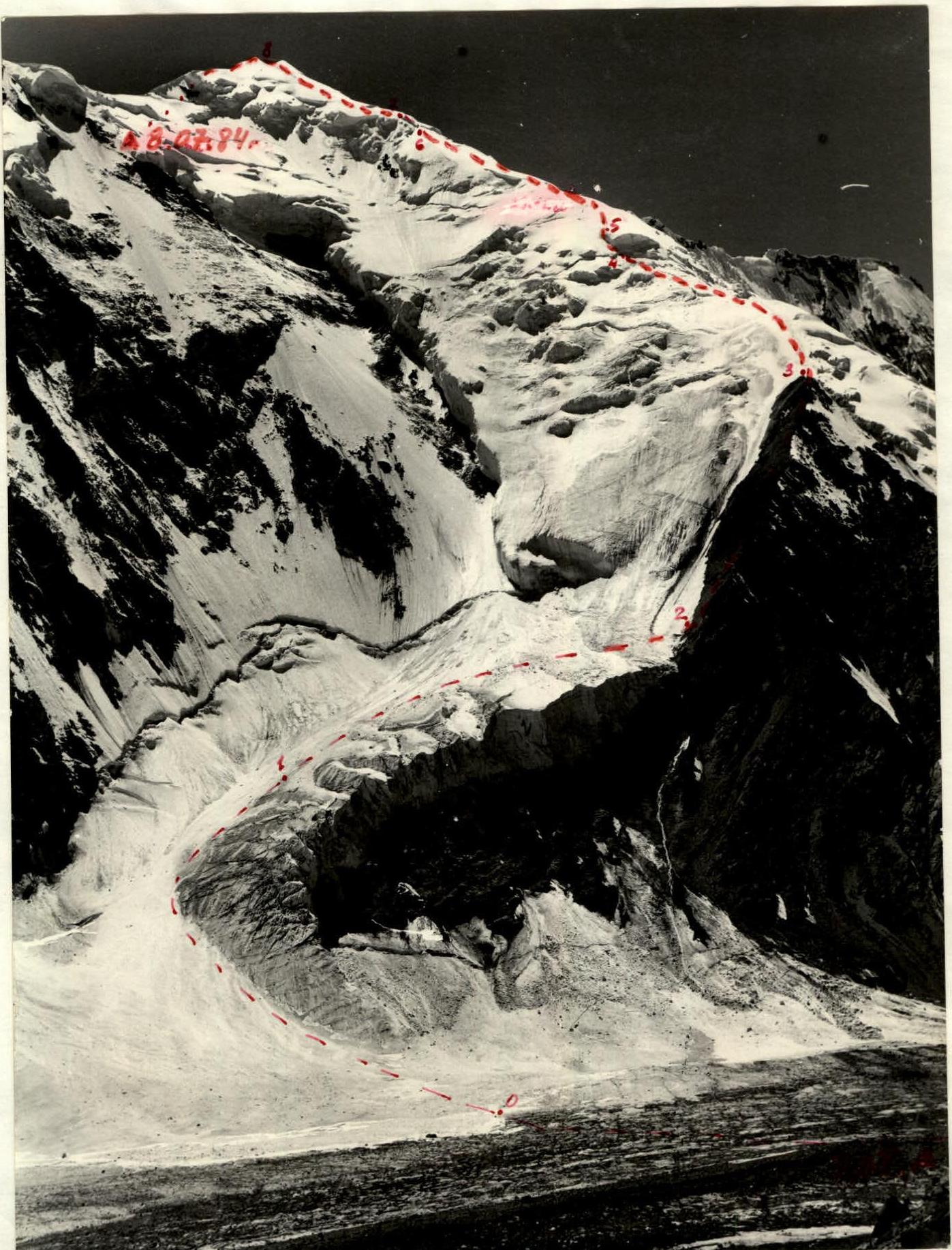
| Date | Section | Avg. slope | Length (m) | Terrain character | Difficulty | Condition | Weather conditions | Rock pitons | Ice pitons |
|---|---|---|---|---|---|---|---|---|---|
| 08.08.1984 | R0–R1 | 45 | 440 | snow-ice slope | 3 | Sun | |||
| R1–R2 | 15 | 300 | Icefall | 2 | Variable cloudiness | ||||
| R2–R3 | 45 | 800 | Destroyed rock ridge | 2–3 | 2 | ||||
| R3–R4 | 40 | 300 | snow-ice slope | 3 | 2 | ||||
| R4–R5 | 70 | 60 | Ice overhang | 5 | 2 | ||||
| R5–R6 | 45 | 360 | Snow slope | 3 | |||||
| R6–R7 | 45 | 60 | Ice crevasses | 5 | 2 | ||||
| R7–R8 | 35 | 480 | Snow slope | 3 | |||||
| R8–R9 | 45 | –350 | snow-ice slope | 4 | Snow | ||||
| 09.08.1984 | R9–R10 | 0 | 900 | Plateau | 2 | Variable cloudiness, sun | |||
| 10.08.1984 | R10–R11 | 40 | 1400 | snow-ice slope | 4–5 | Variable cloudiness | |||
| R11–R12 | 0–45 | 600 | Snow couloirs | 4 | Wind | ||||
| R12–R13 | 40 | 800 | snow-ice board | 4–5 | Fog | 2 | |||
| R13–R14 | 40 | 120 | snow-ice ridge | 5 | Snow | 3 | |||
| Descent from the summit via the ascent route | 5 | 8 |
Description of the route by sections
1st day. August 7, 1984. Departure from the base camp and ascent to the Walter Glacier. Overnight stay due to bad weather. No technical difficulties.
2nd day. August 8, 1984. Early departure from the bivouac. Crossing the Walter Glacier and approaching the hanging icefall. There were no ice falls during the approach to the route. Fast ascent up the dense firn slope (movement in crampons). Exit to the hanging icefall and traverse it to the right towards the rock ridge.
Then, a climb up rocks of medium difficulty to the beginning of the snow-ice fields. Rest. Height 5700 m. Bivouac site.
Straight up, a steep ice slope. Ascent with piton belay. Further, a gentle snow-ice slope abuts an ice ledge, the passage of which requires careful piton belay and attention. Then, we ascend the snow slope. The snow slopes are "soaking," and the ascent is laborious.
Changing the lead rope teams and leaders within the teams, we ascend the snow-ice fields, bypassing crevasses and ledges. At 18:00, we reach "Verblud." Carefully belaying in the rope teams, we descend to the plateau. Belay via ice axes and ice pitons.
On the 6000 m plateau, we set up a bivouac. The weather is deteriorating.
3rd day. August 9, 1984. We woke up early. Visibility is zero. Snow is falling lightly. At 10:00, the weather improves, and the sun comes out. We begin the ascent to the shoulder of p. Kommunizma. Fresh snow fell during the night, making it very difficult to walk. Everyone sinks deeply. After expending a lot of effort, we stop for a bivouac at 6500 m.
4th day. August 10, 1984. The weather is good. Frosty. An early departure for the summit assault allowed us to reach 6900 m on the dense frozen snow. We carefully and with thorough belay pass the snow-ice board. The weather is deteriorating. At a good pace, we exit to the summit of p. Kommunizma at 14:30. Exercising caution, we begin the descent. We successfully return to the previous bivouac site. Overnight stay.
5th day. August 11, 1984. Well-rested, we descend to the plateau. Then, we ascend to "Verblud" and follow the familiar path back to the base camp.
Technical photograph of the route.