Report
On the ascent of the Chelyabinsk regional council team of the "Zenit" sports society to Peak Kommunizma via the 5B category difficulty route for the "Zenit" Central Sports Council championship in the high-altitude climbing class
Chelyabinsk, 1972
Geographical description and sporting characteristics of the ascent route
Peak Kommunizma (7495) rises at the junction of the Peter the First and Academy of Sciences ridges (Fig. 1). The main questions of the orography of the Peak Kommunizma mountain node were resolved in 1932 by an expedition of the USSR Academy of Sciences. To the northeast of the peak lies the powerful Bivachny glacier, and to the southeast of the summit, at an altitude of 6000–6100 m, lies the "Pravda" peak plateau. To the northwest of the summit, at an altitude of 5700–6000 m, along the Peter the First ridge for ten kilometers, lies the Pamir firn plateau, representing an almost flat snow field.
The summit tower of Peak Kommunizma descends steeply on the north and west with rocky slopes. To the west, at an altitude of 6900 m (Photo 1, R11), it is adjoined by a horizontal slope - the "Shoulder" of Peak Kommunizma - which forms the "Big Barrier" of the plateau. From the shoulder, a snow-ice slope descends to the plateau (northwest) with a clearly defined counterfort (Photo 1, R8–R10). This path was first taken by the VTsSPS expedition led by K. Kuzmin in 1957 to reach Peak Kommunizma. The ascent to the plateau was explored and made from the side of the Garmo glacier. And in 1968, three expeditions of the "Burevestnik" sports society conquered Peak Kommunizma from the side of the Fortambek glacier, ascending to the plateau via the "Burevestnik" ridge. Our team chose this route to conquer the highest point of the Soviet Union.
Out of nine routes by which Peak Kommunizma has been conquered, this route is one of the safest and is classified as 5B category difficulty (all routes to Peak Kommunizma are rated not lower than 5B category).
In total, from 1933 to 1972, more than 400 people have conquered Peak Kommunizma.
Brief description of the ascent conditions in the given area
The remoteness from populated areas and inaccessibility of the region served as a serious obstacle to its development until recently. The widespread use of helicopters for development purposes opens up great opportunities for scientific research and further alpine exploration of the area. The flight time from Dzhirgital settlement to the Fortambek glacier (Suloeva meadow) takes 30 minutes, while the caravan path used to take 1.5–2 weeks.
Products for the expedition are best purchased at the place of formation of the expedition or in the city of Dushanbe and delivered to Dzhirgital settlement by car or plane.
The most favorable conditions for ascent in this area are at the end of July - August. During this period, there is a maximum of sunny days. Bad weather, as a rule, does not last more than 1–3 days. On the ridges - strong winds, snowstorms.
The route to Peak Kommunizma via the "Burevestnik" ridge is combined, with a predominance of snow-ice sections, representing either deep snow or hard firn, blown by fierce high-altitude winds. The ascent usually takes 8–13 days.
Reconnaissance exits
According to the general plan of the expedition, during July 15 - August 1, all participants of the expedition were to:
- gain good altitude acclimatization;
- improve their sports form;
- check equipment and high-altitude footwear;
- carry out further reconnaissance of the upcoming route to Peak Kommunizma (the first reconnaissance of this route was done in 1970 during the ascent to Peak E. Korzhenevskaya via Peak Babushkina).
The final stage of this period was to be the ascent to Peak E. Korzhenevskaya. For this purpose, an advance camp was organized under Peak E. Korzhenevskaya, reconnaissance exits and dumps were made to 5100 m and 5800 m. In conclusion, the ascent to Peak E. Korzhenevskaya was made by the entire composition of the expedition (seven people) except for V. Butkov. From the southern ridge of Peak Korzhenevskaya, the chosen route of ascent to Peak Kommunizma was well observed. Detailed consultations on the state of the route were obtained from V. N. Shataev - Honored Coach of the RSFSR, Master of Sports of the USSR, Head of the Climbing Department at the State Committee for Physical Culture and Sports.
Planned composition of the assault group
Based on the results of reconnaissance exits, dumps, and ascent to Peak E. Korzhenevskaya, the following composition was selected for the ascent to Peak Kommunizma:
Davidenko V. N. - leader of the ascent, team captain; Butkov V. L. - participant; Perekhodyuk V. N. - coach; Ponkina T. N. - participant.
Davidenko, Perekhodyuk, and Ponkina were participants in the conquest of E. Korzhenevskaya. Butkov Vitaly did not participate in the ascent to Peak Korzhenevskaya, but proved himself well during dumps and reconnaissance exits and was in his best sports form by the beginning of the ascent.
Tactical plan of the ascent
The tactical plan of the ascent was clear to us even before leaving for the mountains. Corrected according to the results of observations of the route and in connection with the international climbing event, it looked as follows.
The ascent is to be made from the base camp located on Suloeva meadow.
From July 15 to August 1 - acclimatization, reconnaissance exits, and ascent to Peak E. Korzhenevskaya via the southern ridge of 5A category difficulty.
From August 1 to 7 - rest and preparation for the ascent to Peak Kommunizma.
August 8 - ascent via the "Burevestnik" ridge to overnight stays on the "Camel" (5200 m).
August 9 - ascent to the plateau (to the snow ridge crossing the plateau) via the "Parachutists'" peak.
August 10 - ascent across the plateau to the northwest ridge of the "Big Barrier", leading to the western shoulder of the summit; ascent via the northwest ridge to an altitude of 6400 m.
August 11 - exit to the western shoulder of the summit; overnight stay at an altitude of 6900 m.
August 12 - ascent to Peak Kommunizma; overnight stay at an altitude of 6900 m.
August 13 - descent to the plateau.
August 14 - descent to the base camp on Suloeva meadow.
August 15–17 - reserve days for bad weather.
Interaction is to be carried out with the groups of the Odessa "Avangard" sports society and the Leningrad "Spartak" sports society.
Communication with the base camp is to be carried out by radio (up to the "Plato" high camp), visually (with binoculars and a 45x telescope), and with the help of signal flares.
The group decided to go ahead of all teams: Ufa, Odessa, Alma-Ata, Georgia, Leningrad, which were preparing for the ascent around the same time. At the time of the ascent, teams from Kamchatka led by G. I. L. Agranovsky were on the route.
Description of the ascent
Taking into account the good altitude acclimatization of the team members and their excellent sports form (as evidenced by the successful ascent to Peak E. Korzhenevskaya), it was decided to start the ascent to the highest point of the USSR without preliminary dumps.
August 8. Left Suloeva meadow at 8:00. Crossing the Fortambek glacier, approached the start of the route by 9:00. By passing the bergschrund along the snow, approached a simple rock wall, which after five meters leads to a firm talus (R1). The talus is sometimes interrupted by wet areas of rocks from melting snow. By 12:30, approached the snow-ice slope (R2). The weather starts to deteriorate:
- snowdrift;
- tracks are quickly covered;
- on the firm firn lies a small layer of snow;
- ice is increasingly appearing under the snow;
- the ice axe is used frequently.
By 15:30, approached a rock wall, bypassing it on the left along the route via the 40 m accumulated ice, and via 15 m of rockfall to reach the ridge (R3). Here, a warm meeting with the Kamchatka team. According to them, the route is very saturated and complex. Due to bad weather, tracks are quickly covered. Saying goodbye to the Kamchatka team, we ascend along the ridge, representing rocks of medium difficulty. There are many loose rocks. Two-meter walls with a steepness of up to 90° are encountered, but they do not pose a particular difficulty for passage. The ridge leads to a convenient snow mulde, where we find water under the ice. Overnight stay here. Time - 17:30. Very difficult working day. Heavy backpacks are felt, as we are carrying high-altitude footwear in addition to food and equipment. Snow grains are falling. Warm.
August 9. Departure at 9:00 (R4). Excellent weather. Ascent traversing snow-ice slopes (left along the route). Deep snow, does not hold well. Approach the bergschrund, which is overcome with the help of ice axes. Further up the steep snow slope (up to 60°) to the ridge. Along the ridge and firn slope, covered with loose snow, to the ridge rocks (100 m). Difficult section. Ice is felt under the deep snow. Rocks are bypassed on the left along the route (150 m) and then exit to the ridge (40 m) via ice with a steepness of up to 40°. We are wearing high-altitude footwear (shekeltons and valenki). Everyone wore crampons. Boots were left at the overnight stay. Further, a relatively easy exit to a snow dome (300 m). Snow up to the ankles. Leaders frequently change.
Approach the "Parachutists'" rocks (R5). First, we go along a simple rocky ridge covered with snow. Then, with careful belay, we bypass the rocky section on the right along the route, exiting to the summit and further to the plateau. Time 13:00.
Sinking deeply into the snow, we try to find the optimal path across the plateau. At times, the person in front sinks up to the knee. Perekhodyuk is in front, followed by Butkov. Both choose the path excellently. And despite the heat and heavy snow, the group reached the snow ridge by 15:30. Overnight stay in a cave. 6 hours 30 minutes of walking time.
August 10. Departure at 8:15. Movement across the plateau (R7). We move quickly. The snow is significantly easier than yesterday. By 11:30, reached the southwest counterfort of the Big Barrier. Along the left slope, we start ascending the counterfort (R8). In the lower part of the path lies fluffy snow. After an hour, we pass the bergschrund and exit to the convex part of the counterfort. Steepness 40°. Here, the snow is compacted by winds, and in some places, traces from our crampons are visible. It's hard to move. By 15:30, it started snowing. Visibility sharply worsened. We stop at the first convenient site for an overnight stay. Time 16:00.
- Heavy snowfall, but warm.
- 7 hours 45 minutes of walking time on this day.
- By evening, a strong wind picked up, which raged all night, trying to tear the tent to shreds.
- The tent was buried twice during the night.
Altitude 6400 m.
August 11. After a sleepless night, a late departure. Strong wind, snowdrift. Very cold. Departure postponed until 12:00. Left at 12:00. In the breaks in the clouds, the sun was visible. We approach the rocks, the steepness of which does not exceed 25° (R9), and we do not yet use belay. In some places, the counterfort has destroyed rocks. Altitude 6500 m.
Further ascent to the "shoulder" of Peak Kommunizma along a slope of great steepness (R10):
- dry, loose snow;
- sometimes the first person has to dig a trench with hands and feet;
- from time to time, under the snow, we stumble upon ice steps left by participants of the climbing event 10–14 days ago.
The altitude is approaching 6900 m. A few more steps, and the slope becomes gentler. We exit to the horizontal part of the Big Barrier. The tower of the summit is very close. We stop at a convenient mulde for an overnight stay. Time - 15:30. Worked for 3 hours 30 minutes. Well-being and appetite are excellent. At 9:00, we give a green flare: everything is in order.
August 12, Assault Day. Left at 9:15. The sky is clear, cloudless. On the ridge, a strong wind is felt. We approach the tower along a small descent (R11). Further, it was necessary to exit to the firn slope (R12), in some places of which ice shone through. We go in one rope: on the whole rope - Davidenko, Butkov, Ponkina, and Perekhodyuk as the last. We bypass the rocky massif of the tower on the left along the route (160 m) in the direction of a small rocky ridge, passing which (40 m), we move along the steep (40°) firn slope of the northeast ridge. Crampons hold perfectly. By 13:00, we passed the deceased Ufa team. Everyone is extremely attentive, although the most dangerous section is ahead, on the ridge.
By 15:00, we are on the ridge. Having passed 1.5 ropes along the ridge, we ascend along the steep (45°) summit ascent (150 m). At the summit, the snow ends, and the highest point of the Soviet Union is formed by layered schist with a large number of crystals resembling pyrite.
At 15:40, we stood on Peak Kommunizma. We take the note of the team of Master of Sports Afanasiev (Moscow, "Spartak"), who ascended an hour earlier than us via the Tamm route. We saw the participants of this group when we were ascending the summit ascent. From afar, we greeted each other with signs.
Vitaly Butkov's well-being is deteriorating. Very strong wind and cold. Faster down! Careful belay! Descended to the shoulder by 19:00. The weather worsened. By 20:30, we settled comfortably in the tent. We examine each other. We rub frozen hands and feet. We treat Vitaly. We cook dinner. Worked 11 hours 15 minutes on this day. At 21:00, we give a green flare.
August 13. The night passed well. Left the bivouac at 11:30. Butkov has only down clothing. We go in one rope. Along the way, we meet numerous teams: Odessa, Ufa, Georgia, Alma-Ata, Leningrad - ascending to the Big Barrier. By 15:00, we descend to the plateau. Stopped for an overnight stay at 19:00 near the caves. Contacted the base camp by radio and reported on Butkov's condition. Kuibyshev doctors (O. Khramov and Benkin) thoroughly examine Vitaly. Pneumonia may begin. Tomorrow, we need to descend to Suloeva meadow. We spend the night in a tent, Vitaly - in a cave (with doctors). Worked 7 hours 30 minutes on this day.
August 14. Left at 10:00. Vitaly is moving much faster. By 12:00, we are already on the "Parachutists'". With careful belay in one rope, we descend to 13:30 to the overnight stays on the "Camel". Arrived at Suloeva meadow by 18:00. Here, we are surrounded by care and attention.
The entire ascent was made in 43 hours of walking time. The group's behavior on the route above 7000 m was perfectly observed through a telescope from the base camp. The group was provided with reliable radio communication up to the "Plato" high camp and regularly maintained communication with the base camp using signal flares.
All participants of the ascent worked clearly and harmoniously on the route. The participants are physically and technically excellently prepared and represent a collective with high moral and volitional qualities.
Team captain V. Davidenko
Coach V. Perekhodyuk
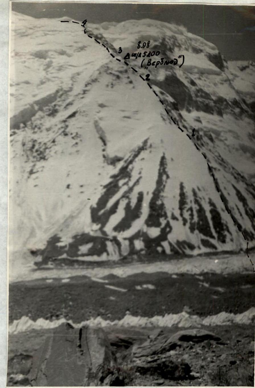
PHOTO 2. "BUREVESTNIK" RIDGE
TABLE of main characteristics of the ascent route to Peak Kommunizma from the Fortambek glacier via the "Burevestnik" ridge Height difference of the route: 7495 m – 3900 m = 3595 m, average steepness of the route 37°.
| Date | Section | Average steepness on the section, ° | Length of the section, m | Relief | Technical difficulty | Passage | Belay | Weather conditions | Departure time | Arrival time | Time en route | Driven pitons | Overnight stay conditions |
|---|---|---|---|---|---|---|---|---|---|---|---|---|---|
| 8.08 | R1 | 30–40 | 700 | Firm talus | Simple | Simultaneous | Good | Good | 8:00 | 17:30 | 9:30 | Good | |
| R2 | 35–40 | 500 | Firn, ice on bypass | Medium | Ice axe | Difficult | Snowdrift, medium | 2, 2, 1 | Medium | ||||
| R3 | 45–65 | 400 | Destroyed rocks | Medium | Alternating, pitons | Medium | Snow grains | Medium | |||||
| 9.08 | R4 | 35 | 700 | Snow, bergschrund; firn, ice on bypass | Medium | Ice axe, steps, pitons | Medium | Excellent | 9:00 | 15:30 | 6:30 | 3 | Good |
| R5 | 25 | 300 | Snow-covered rocks | Easy | Simultaneous | Medium | Medium | 2 | Medium | ||||
| R6 | 4000 | Snow | Fresh snow, местами deep | Simultaneous | Medium | Medium | Medium | ||||||
| 10.08 | R7 | 4000 | Medium | Simultaneous | Medium | Good | 8:15 | 16:00 | 7 h 45 min | Bad: snow and strong wind | |||
| R8 | 35 | 700 | Firn | Medium | Ice axe | Medium | 15:30 snowfall | ||||||
| 11.08 | R9 | 20–30 | 200 | Snow-covered rocks | Easy | Simultaneous | Medium | Wind, cold | 12:00 | 15:30 | 3 h 30 min | Satisfactory | |
| R10 | 40 | 600 | Firn | Medium | Ice axe | Medium | Medium | ||||||
| 12.08 | R11 | 700 | Snow | Easy | Simultaneous | Medium | Clear, but cold | 9:15 | 20:30 | 11 h 15 min | Satisfactory | ||
| R12 | 40 | 800 | Firn | Medium | Ice axe | Medium | Strong wind | ||||||
| R13 | 45 | 200 | Snow-covered rocks | Difficult to organize belay | Alternating | Medium | Medium | ||||||
| 13.08 | Descent to "Plato" high camp | ||||||||||||
| 14.08 | To base camp on Suloeva meadow |
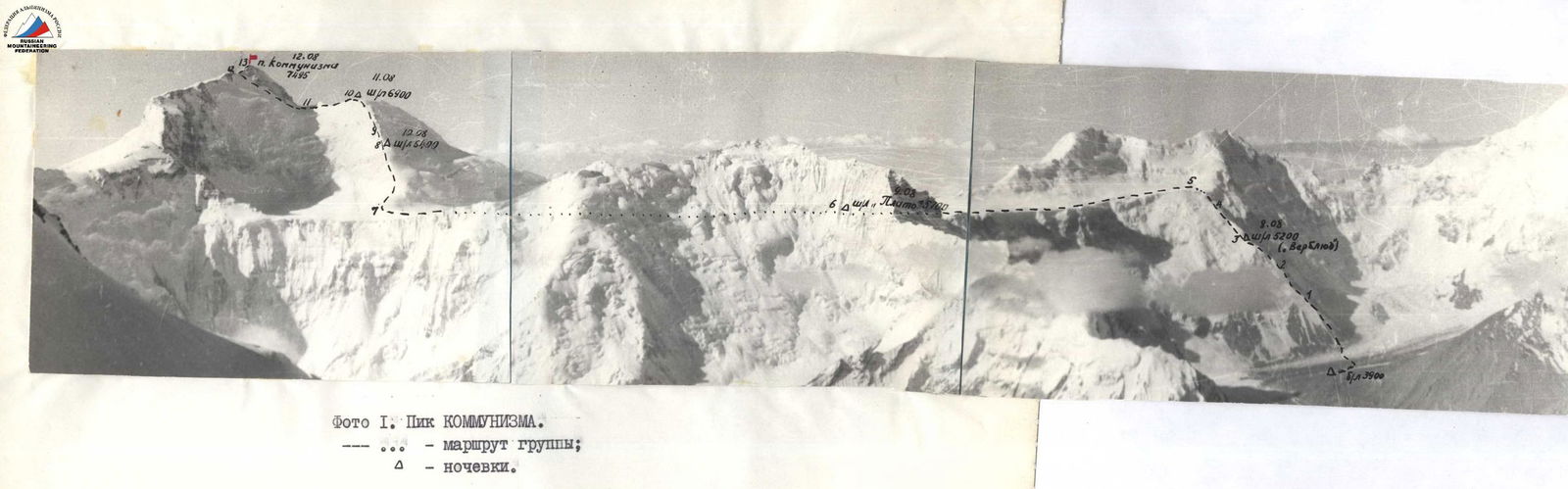
Photo 1. PEAK KOMMUNIZMA. →... — route of the group; Δ — overnight stays.

