Report
On the traverse of the peaks of Kommunisticheskaya Akademiya — "6045 m" — Garmo, performed by the combined team of the Armed Forces in 1972 (North-West Pamir)
Historical and geographical overview and characteristics of the area
In 1928, participants of the Pamir expedition of the USSR Academy of Sciences, topographer I.G. Dorofeev, first crossed the Academy of Sciences range from east to west and discovered a large glacier flowing into the Vanch valley. The glacier was named after the Geographical Society. The length of the glacier was determined to be 18 km. The glacier is located in the upper reaches of the Vanch river valley. In the area of the Kasal-ayak pass, it seems to merge with the Fedchenko glacier. However, the main branches of the RGO glacier originate from:
- the southern slopes of Garmo peak, one of the largest centers of glaciation in the north-western Pamir;
- the south-western slopes of Kommunisticheskaya Akademiya peak.
To the south, the RGO glacier receives a large tributary — the Krasnoarmeets glacier. A detailed study of the RGO glacier was conducted in 1948 by a comprehensive geographical expedition of Moscow University. The total length of the glacier from the slopes of Garmo and Komakademiya was determined to be 21 km. The width is about 1 km.
The RGO glacier is dominated by two high peaks:
- Garmo peak;
- Kommunisticheskaya Akademiya peak.
And if Garmo peak has long attracted the attention of geographers and climbers, having its local name, then Kommunisticheskaya Akademiya peak received its name only in 1928, during an expedition led by the tireless Pamir researcher N.V. Krylenko.
For many years, both peaks have attracted the attention of climbers, but the complexity of the ascent to these peaks has repeatedly deterred athletes. And now, on the eve of the 50th anniversary of Soviet mountaineering, when hundreds of athletes have climbed Peak Kommunizma, when the peaks of Pobeda and Khan-Tengri have been conquered by many dozens of ice climbers, ascents to Komakademiya and Garmo peaks still remain isolated cases.
For the first time, climbers ascended Garmo peak in 1948, and one must pay tribute to the courage of A. Bagrov, V. Ivanov, V. Mukhin, A. Ivanov, I. Daibog, A. Gozhev, and V. Gusev, who reached the summit on August 30. The ascent was made from the Vavilov glacier along the northern ridge, via the route that N.V. Krylenko had dreamed of taking. The ascent to Garmo peak was the greatest achievement of Soviet mountaineering. The climbers had to set up nine camps during the ascent to the summit.
Nine years later, in 1957, Georgian climbers successfully pioneered a new route to Garmo peak from the Vanch valley, ascending from the western branch of the RGO glacier.
In 1962, a group of Soviet-British climbers ascended to the peak via the route taken by the first ascenders from the Vavilov glacier. Unfortunately, two British climbers were killed during the descent.
And finally, in 1969, climbers ascended Garmo peak for the fourth time, again from the Vavilov glacier, but via a new, more difficult route. These were Leningrad climbers led by Yu. Kuzmin.
The history of ascents to Kommunisticheskaya Akademiya peak is even shorter. The first serious attempt to conquer this beautiful Pamir peak, which is very reminiscent of Ushba, was made in 1962 by Uzbek climbers led by MS USSR Zil'nibekov. The route was chosen along the south-eastern ridge. The climbers were unable to ascend higher than 5300 m. Bad weather and the complexity of the route prevented them from reaching the summit.
And only in 1965, Uzbek climbers realized their long-held dream. A group led by P'yankov successfully completed what they had previously planned. The south-eastern ridge of the southern summit of Komakademiya peak was traversed.
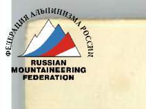
The second passage of Komakademiya peak was successfully completed in 1971 by a team of the Armed Forces led by MSMK Bitnyy A.V. The team made a extremely difficult ascent to the southern summit along the southern wall, then ascended to the northern summit and descended to the RGO glacier along the steep north-western ridge. The route was duly rated 6B category of difficulty.
Exploration of new routes by an expedition of army climbers formed the basis of the Armed Forces expedition in 1972. The reconnaissance showed that an ascent to Komakademiya peak along the south-western wall directly from the RGO glacier was feasible.
As often happens, one idea gives rise to another. A more daring, at first glance, seemingly unlikely idea emerged — to connect the two formidable peaks into a single whole, i.e.:
- to combine a wall ascent to Komakademiya peak;
- with a subsequent traverse of Garmo peak.
Moreover, the eastern ridge of Garmo peak represented, perhaps, the most difficult unattempted route to the peak.
This issue was debated at length in the section. The only doubt was whether there would be enough strength to solve such a sporting task. Practically all the best climbers of the Armed Forces, who had repeatedly proven themselves in difficult ascents in the Caucasus and Pamir, were involved.
The idea of a traverse captivated almost everyone, and perhaps most of all — with its technical complexity. The instability of the weather was not always taken into account.
A few words about the incorrect orientation of the routes ascended before 1972 to Komakademiya peak.
Komakademiya peak has two summits:
- the northern one, 6439 m high;
- the southern one — 6370 m (according to our estimate).
Between the summits is a saddle, with an approximate height of 6230 m (also according to our estimate). The summits are strictly oriented from north to south.
From the southern summit, a steep south-eastern ridge extends towards the weather station on the Fedchenko glacier, along which the first ascent to the southern summit was made in 1965.
The fact that the ridge is south-eastern is stated in the article by V. El'nikov, A. P'yankov, and G. Krukovskiy "Storming the six-thousanders of the Academy of Sciences range" on pages 65, 71, and 72 (see "Conquered peaks" 1965–1967).
And in the official classification of peaks, this route is listed as the north-eastern wall. This error led to another. Subsequent climbers in 1971 called their route along the southern wall the south-eastern one and also officially entered it into the classification table.
Based on the thus oriented routes, applications were submitted in 1972 with the already existing incorrect orientation.
As a result of this year's expedition and the routes ascended, it is necessary to correct the orientation of the previously ascended routes in 1965 and 1971 to:
- the 1965 route should be considered, as the first ascenders did — Komakademiya peak via the south-eastern ridge;
- the 1971 route should be considered — Komakademiya peak via the southern wall.
The routes ascended by army climbers to Komakademiya peak via the south-western wall correspond to its actual orientation. 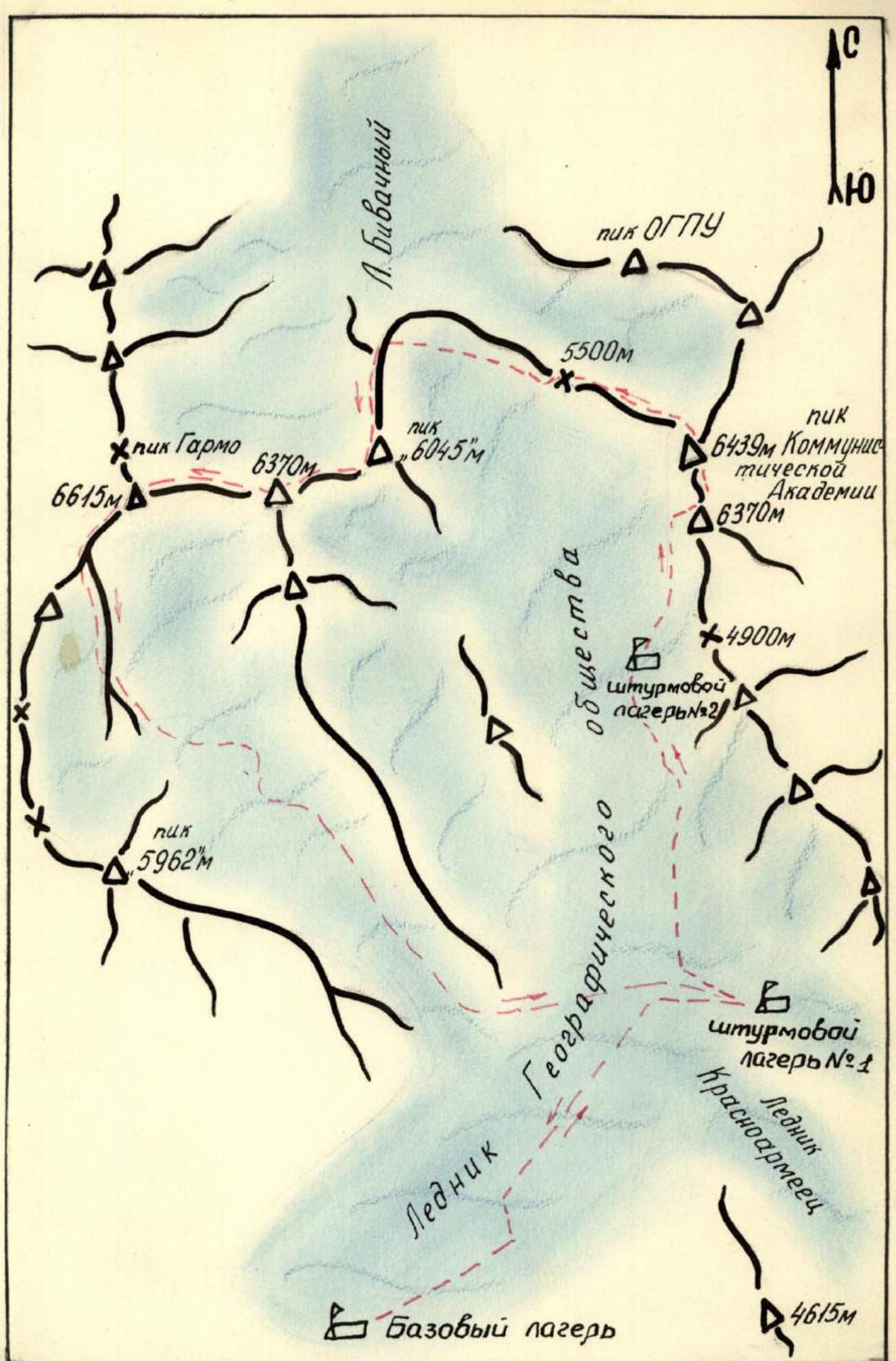
Map of the ascent area
Northern summit
Southern summit
Panorama of the traverse
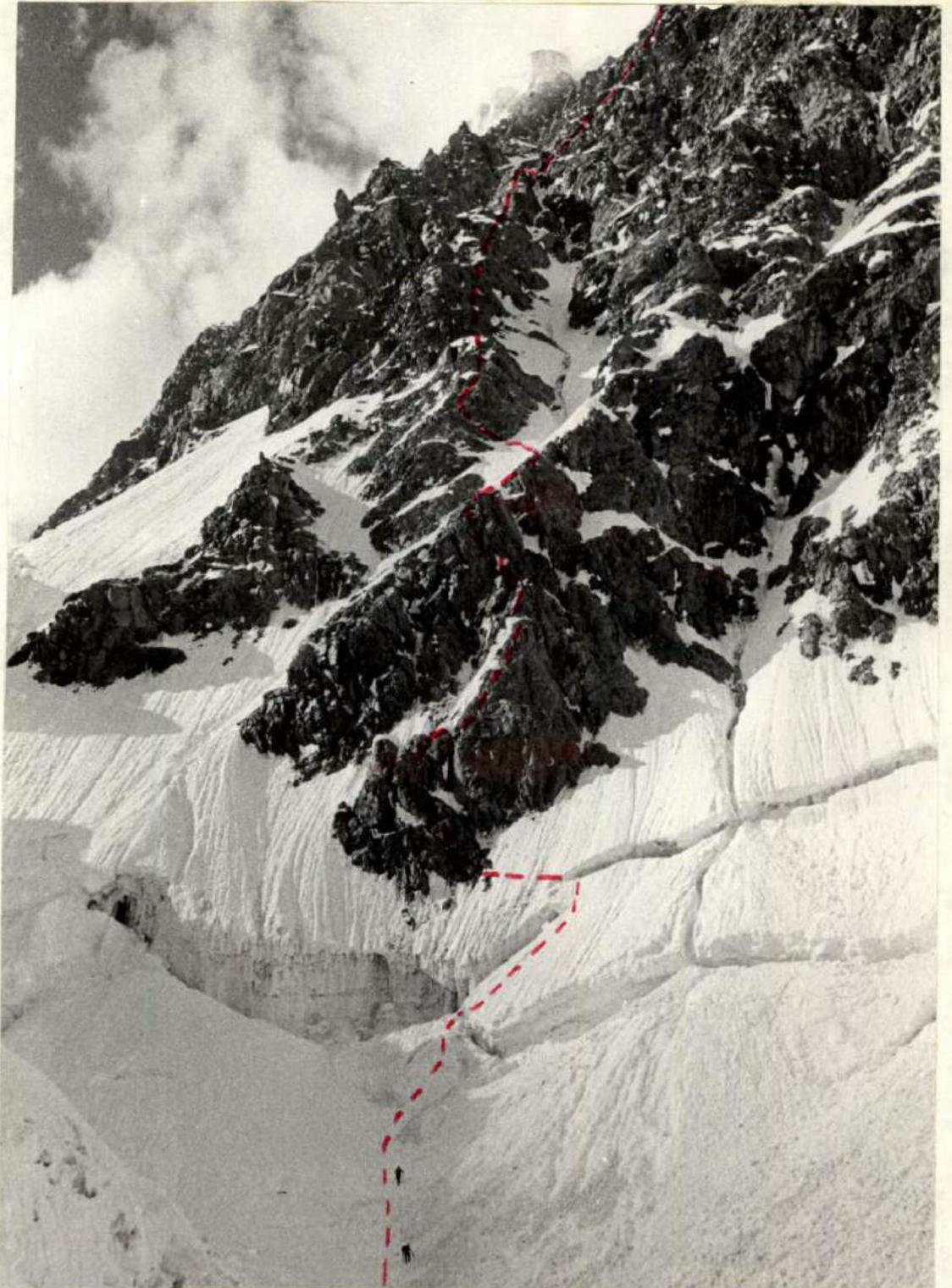
The lower part of the route along the south-western wall of Komakademiya peak.
- Since the length of the traverse was at least 10 km, and its complexity was beyond doubt, the assault group was determined to be 8 people with the maximum possible distribution of experienced climbers among the ropes. For the same reason, "high-altitude" climbers were included:
- NEKRASOV;
- STAROSELETS;
- AKHVLEDIANI;
- CHEPIGA.
- The passage of the south-western wall of Komakademiya peak was planned at a somewhat slow pace to conserve strength for the subsequent traverse of the Garmo massif.
- A half-day rest was planned on the 5500 m col after descending from Komakademiya peak.
- Preliminary processing of the lower 200 meters of the wall was planned upon arrival at the route.
- Since the ascent to the northern ridge of "6045 m" peak from the 5500 m col goes from the eastern side along a snow-ice slope, the time of ascent was planned for the second half of the day.
- Night camps on the eastern ridge of Garmo peak were planned on the least steep sections — "cushions".
- The descent from Garmo peak was to be made along the southern ridge — the route taken by the Georgian climbers in 1957 during the traverse of the Darvaz wall.
- In case of a need to descend during the traverse, two options were considered: a) after descending from Komakademiya peak, from the 5500 m col to the RGO glacier; b) after descending from "6045 m" peak, from the 5700 m col to the RGO glacier.
- During the traverse, on the section of the ascent to Komakademiya peak along the south-western wall, the team interacted with Matyushin's team — constant visual and voice communication, as well as radio communication and signal flares. During the further traverse, there was interaction with Bandurovskiy's support group, which was first in camp № 2, and then in camp № 1.
- Data on the team's movement was transmitted by radio from camp № 1 to the base camp and further to Osh.
At the coaching council on August 2, the compositions of the assault groups were finally approved. From the main composition, заявленный in the championship, DEMCHENKO A.S. and SARKISOV L. did not arrive at the gathering. Team member IVANOV G. was not allowed by the gathering's doctor due to illness. Therefore, participants from the reserve composition were included: AKHVLEDIANI G., NEMSITSVERIDZE N., and CHEPIGA V. Thus, the team set out on the traverse in a composition of 8 people:
- NEKRASOV V.P. — MSMK.
- STAROSELETS E.V. — MS.
- VARDANYAN G.G. — MS.
- MASLENNIKOV A.S. — CMS.
- AKHVLEDIANI G.D. — CMS.
- BARANOV V.A. — CMS.
- CHEPIGA V.K. — CMS.
- NEMSITSVERIDZE N.V. — CMS.
All participants had joint climbing experience both in the 1972 season and in previous seasons. All participants are champions of the Armed Forces in the 1970–1971 seasons, and NEKRASOV and STAROSELETS are multiple prize-winners of the USSR championship.
August 3. Base camp — assault camp № 1. Movement first along the trail on the left (orographically) side of the RGO glacier, then crossing to the center of the glacier to camp № 1. The glacier is very calm. Travel time — 6 hours.
August 4. Ascent from camp № 1 to camp № 2. In camp № 1, an observation group led by Galaktionov remains. The group includes a radio operator. The ascent goes along the left (orographic) side of the RGO glacier. Icefalls are bypassed along previously processed rock walls. After the 2nd icefall, a turn to the right into a snow couloir and exit to the 3rd terrace of the glacier. The detour along the rocks took 3 hours. Total time taken for the ascent to camp № 2 — 7 hours.
August 5. Ascent at 5:00. Departure at 7:00. In the camp, Bandurovskiy's group remains. Two teams — 12 people — ascend. 8 people are on the traverse, 4 people are on the south-western wall to Komakademiya peak. From camp № 2, movement goes to the right along a steep snow slope towards the wall. The teams approach the start of the route at 10:00. Tents are set up. The distance between the bivouacs of the teams is about 500 m.
Until 15:00, observation of the wall's regime was carried out. During the day, there were strong rockfalls and avalanches. It was gratifying to see that the planned ascent route was completely safe. At 15:00, the duo STAROSELETS–NEMSITSVERIDZE began processing the lower part of the wall (lower triangle). In 5 hours, they processed R3–R9. R6 and R8 turned out to be particularly difficult, as well as overcoming the bergschrund. R8 is a vertical wall — an internal angle with a cork on top. In the future, this section was passed without backpacks, with subsequent pulling.
August 6. Fog and rain in the morning. Visibility 8–10 m. August 7. The weather has not changed. The second day at the bivouac under the wall. August 8. The weather has somewhat improved. It is decided to deliver additional fuel and food from camp № 2 in case the bad weather continues. The quartet MASLENNIKOV, CHEPIGA, BARANOV, and VARDANYAN perform this task during the day. August 9. The weather improves in the morning. Visibility increases, light snow. Departure from the bivouac site at 8:00. In 4 hours, the sections processed on August 5 are passed. The rocks are snow-covered, and in some places, icy. The pace of movement is not high. We approach a snow ridge (R10) and then a snow-ice couloir. This is a dangerous section. The couloir is possible not only for avalanches but also for rockfalls. The width of the couloir is 40 m, steepness about 60°. Careful piton insurance, both on rock and ice pitons. Constant observation of the top.
The route to the lower parts of the wall goes along the left edge of the triangle. The vertex of this triangle is a characteristic "ear" gendarme. We need to reach these "ears", but it's still very high. For now, the path goes along smooth slabs (R14), then two characteristic gendarmes on a snow-rock ridge, and again difficult steep slabs. We exit onto a steep ridge with snow cornices. Above the ridge stands a vertical smooth wall, to the right is a sheer drop. To the left is a narrow ledge that runs along the lower part of the wall. Obviously, this is where we need to look for the ascent route. It's already evening. The ridge is very narrow. There's nowhere to set up tents. We cut down the cornices and settle in for a sitting bivouac. A very difficult day. A lot of "piton" work. 13 ropes were passed during the day. We settle in for the night at 22:00. The working day is 12 hours. In the evening, at 20:30, there is a radio communication session with Matyushin's group and signalling with flares with Bandurovskiy's group and camp № 1. Matyushin reported that his team will start the assault tomorrow morning.
August 10. In the morning, they waited for the sun. Dried equipment and tents. Departure from the bivouac site at 10:00. Complex climbing along a narrow ledge, then 5 m to the left along a barely noticeable ledge, and 4 m up a wall — exit to a 0.5 m wide ledge. These sections are very well passed by MS VARDANYAN. Then, one of the best rock climbers, NEMSITSVERIDZE, joins him, and together they overcome a 20-meter wall with flowstone. Pitons are used as points of support. Above the wall, on a very small ledge, a "receiving point" for backpacks is organized. A complex ascent of backpacks from the bivouac site to the top of the wall begins. This entire section required about 5 hours of work.
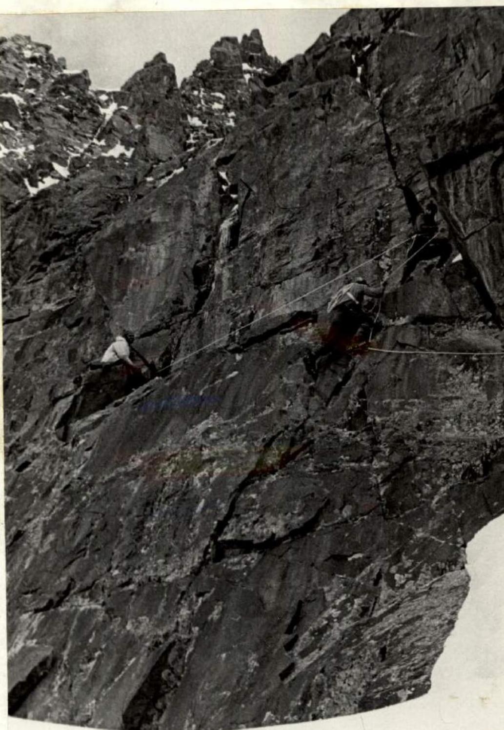
The further path goes along a rocky ridge, where rocky walls alternate with slabs and steep sections. The most complex sections are R29 and R30.
By evening, the team reaches under the "ear" gendarme, which directly overhangs the route with a wall. All sections are so steep that there's nowhere to set up tents. Under the gendarme, two ledges were found to sit on, and a bivouac was set up for 4 people each.
- The second sitting bivouac.
- We knew in advance that it would be bad until the top of the triangle with bivouacs, but we hoped to pass the lower part of the wall somewhat faster.
- The wall prevented us from reaching the top of the gendarme, taking too much time.
- 11 ropes were passed during the day.
- The working day — 10 hours.
At 9:00 in the morning, they saw Matyushin's group departing from their bivouac site. In the evening, there was radio communication with him. They reported that the route in the lower part of the wall is very difficult. Bandurovskiy's group approached the wall and set up a bivouac, observing both assault groups. The night's rest was very uncomfortable and cold. They slept very poorly.
August 11. Departure from the bivouac site at 10:00. An attempt to bypass the gendarme to the right was unsuccessful. The path was blocked by a completely sheer wall that turns into an ice slope. Directly above, the wall has a negative incline. To the left, a steep ledge with flowstone extends. Careful piton insurance. The ledge leads to an ice-rock couloir. The steepness is at least 70° (R33). This section was very well overcome by MASLENNIKOV. He passed without a backpack, in crampons, using rock and ice pitons. The couloir leads to the top of the "gendarme", a narrow rocky ridge that is overcome "on top". The rocky ridge turns into a snowy ridge. The steepness drops sharply to 45°, and then to 40°. Fatigue is felt after 2 sitting bivouacs. It is decided to set up a bivouac earlier than usual, especially since the place for the bivouac is simply excellent. 6 ropes were passed during the day. The working day — 7 hours. Matyushin's group is in visual visibility, parallel to us. We are separated by a deep couloir that runs along the entire wall from the glacier. Major avalanches and rockfalls occur along this couloir.
August 12. A very good rest during the night. In the morning, they decided to make a late departure, drying equipment and tents. Departure from the bivouac site at 12:00. Directly above the bivouac is a rocky ridge with steep rocks. Movement goes along the left part of the ridge. A characteristic gendarme in the upper part of the ridge is bypassed on the left. This section marks the end of the lower part of the wall, which turned out to be more complex than we expected. Until the very gendarme "ears", there was not a single platform for setting up tents. This circumstance should be taken into account by subsequent climbers.
The middle part of the wall is less steep and represents snow-ice slopes of a wide couloir that begins to the left of the saddle (closer to the northern summit). To the right, above, the black walls of the upper part of the wall (summit tower) are visible. From the bivouac site, movement goes directly upwards along a snowy ridge (R37), then begins to cross a steep snow-ice slope (couloir) at an angle of 45–50° (upwards to the right). The couloir is in very good condition. For each rope, 1 ice piton is used. After 4 ropes of movement, we reach the black rocks. The first 40 m go along a steep rocky ridge, then movement goes along a ledge to the left — upwards to a small snowy ridge, along which we exit onto a gentle snowy saddle. The saddle abuts a vertical rocky wall. A good place for a bivouac. 11 ropes were passed during the day. The working day — 8 hours.
August 13. The height is around 5500 m. Night camp on snow. Quite cold. The summit tower, or rather the upper part of the wall, lies before us. Departure from the bivouac site at 13:00. The wall above the bivouac appears quite formidable.

Ascent along the snowy ridge R34–R35. Impression.
NEKRASOV passes the first 40 meters without a backpack:
- First 5 meters up;
- then 5 m to the left;
- further to the right to the internal angle.
The angle is vertical, about 15 m high. It is passed first directly up, then a transition to the left wall — difficult climbing, artificial points of support, and exit to a steep rocky "knife" that leads to a small platform (R42).
The second 40 meters of the wall are confidently passed by BARANOV:
- First, movement along a narrow ledge to the right — upwards;
- then an internal angle;
- further to the left along rocky slabs.
Exit to a ledge. From the ledge, again an internal angle with a steepness of about 70°. The length of the saddle is 60 m. The saddle again leads to a rocky wall.
Again, NEKRASOV passes this rocky section. Steepness 80°. Rocky walls alternate with an internal angle (R46). The wall ends with a 20-meter rocky ledge. Then there is a 5-meter vertical wall. Further to the left — a 5-meter ledge, and after that, rocky slabs that lead to a rocky couloir.
The couloir is very steep and complex. It is very well passed by VARDANYAN. The top of the couloir ends in a gentle saddle, very convenient for a bivouac. 8 ropes were passed during the day. The working day — 9 hours. The entire day — complex climbing on rocks. To the right of us is a deep couloir, above which is the summit tower. Matyushin's group also approached under the summit tower. They are on the other side of the couloir. We established voice communication. Matyushin reported that the group's condition is good.
A control tour was set up at the bivouac site.
August 14. Departure from the bivouac site at 10:00. First, ascent directly up the wall — 5 m, then to the right along a slab (careful piton insurance), further to the left — another rocky wall, and exit to a snow-rock ridge. Along the ridge, we approach under the нависающих скал. The "gendarme" is bypassed on the left along a steep rocky ledge with ice. A very difficult section (R56), successfully overcome by CHEPIGA in a calm, academic style. After bypassing the "gendarme", movement goes directly up along steep destroyed rocks covered with snow. We exit onto a snowy ridge. The steepness drops to 40°. Along the snowy ridge, we approach under the summit tower. We begin the ascent along the rocks of the summit tower. First, along a couloir, then to the right — upwards — exit to a ledge (R61). Setting up a bivouac. Seven days of work on the wall. Fatigue is felt among team members. The height — about 6000 m — also takes its toll. Fuel is running low, but food supplies are better. There's not much left to the summit. For the second day, a strong wind blows. 12 ropes were passed during the day. Working hours — 8.
August 15. A strong wind in the morning. Departure from the bivouac site at 12:00. The first 30 m directly up from the bivouac along a rocky ridge, then onto a ledge to the right. Further, the path goes to the left — upwards along a rocky ridge covered with snow. The ridge leads to a ledge. From the ledge, movement goes directly up along rocks to a vertical wall. The wall is traversed to the left — upwards with careful piton insurance. Further — complex climbing along an 80° rocky wall, which leads to a wide ledge running from the saddle to the southern ridge at the height of the saddle. We move to the left along the ledge towards the saddle (80 m) and approach a rocky-snowy couloir. A straightforward ascent, and the team exits onto the saddle between the southern and northern summits. Now it can be considered that the wall is practically passed. The summit is a straightforward ridge. The saddle is a snowy field. For the first time in a week, backpacks are shed, and one can walk freely on a large platform without a rope. We reached the saddle at 20:30. 10 ropes were passed during the day. The working day — 8.5 hours.
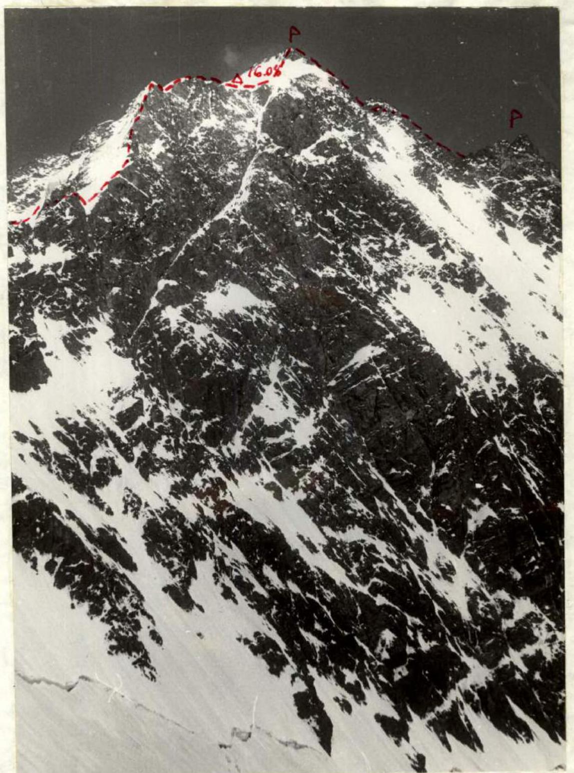
August 16. The sun illuminated the bivouac early, as the saddle is oriented towards the east. Departure from the bivouac site at 9:30. The height of the saddle, according to our estimate, is around 6250 m. Without backpacks, movement is quite fast. From the saddle to the tour on the southern summit, there are only 8 ropes, with 5 of them along the ridge. The team reached the summit in 2 hours 30 minutes, at 12:00. From the tour, they extracted a note from last year's climbers — the team of the Armed Forces led by BITNYY. Interestingly, the note had been lying for exactly 1 year, since August 16, 1971.
The descent to the saddle took 1.5 hours. After rest and dismantling the bivouac, the team began the ascent to the northern summit. The route also goes directly along the ridge. In the lower part, the ridge is very simple, then becomes more complex, and the main difficulty is overcoming an 80-meter rocky wall before exiting onto the summit ridge. The length of the ascent to the northern summit is about 10 ropes. The time taken for the ascent is about 4 hours. The team reached the summit at 19:00.
At 19:15, the descent began along the north-western ridge. The descent route is familiar to us from last year's description. Moreover, one of our team members, STAROSELETS, was part of last year's ascent. A bivouac was decided to be set up in an icy cirque, which is 40 minutes down from the summit. At 20:00, they approached the cirque. Indeed, the site was as if specially prepared for camping: windless, safe, and flat. A note from Bandurovskiy's group, which had ascended to this summit from the 5500 m col, was retrieved from the northern summit. At the time the team reached the northern summit, Matyushin's group was seen descending to the saddle from the southern summit. An example of complete interaction and insurance. Voice communication was established with them. 10.5 working hours were spent during the day.
North-western ridge of Komakademiya peak (descent route from the northern summit, to the right — southern summit).
August 17. Departure from the bivouac site at 11:00. In the morning, they carefully examined the route for further traverse. From here, everything is visible as if on a palm. Garmo peak makes a very formidable impression. Once again, they considered the places for night camps. The descent to the 5500 m col is quite complex:
- 4 ropes of descent were made along vertical walls;
- there are many icy sections on the ridge;
- 12 rock and ice pitons were hammered during the descent.
The descent was facilitated by the fact that the tracks of Bandurovskiy's group's ascent and descent were visible. At 17:00, the team descended to the lower point of the entire traverse — the 5500 m col. Half an hour later, Matyushin's group descended. We warmly congratulated our friends on their remarkable ascent.
To the great disappointment of the team, 3 participants cannot continue the further traverse: BARANOV, CHEPIGA, and NEMSITSVERIDZE. The reasons are as follows:
- NEMSITSVERIDZE must arrive in Tbilisi on August 22 to take exams at the institute.
- BARANOV and CHEPIGA's business trips end on August 22, 1972.
Bad weather not only delayed the team under the route but also complicated the passage of the route itself. Our companions' disappointment knows no bounds.

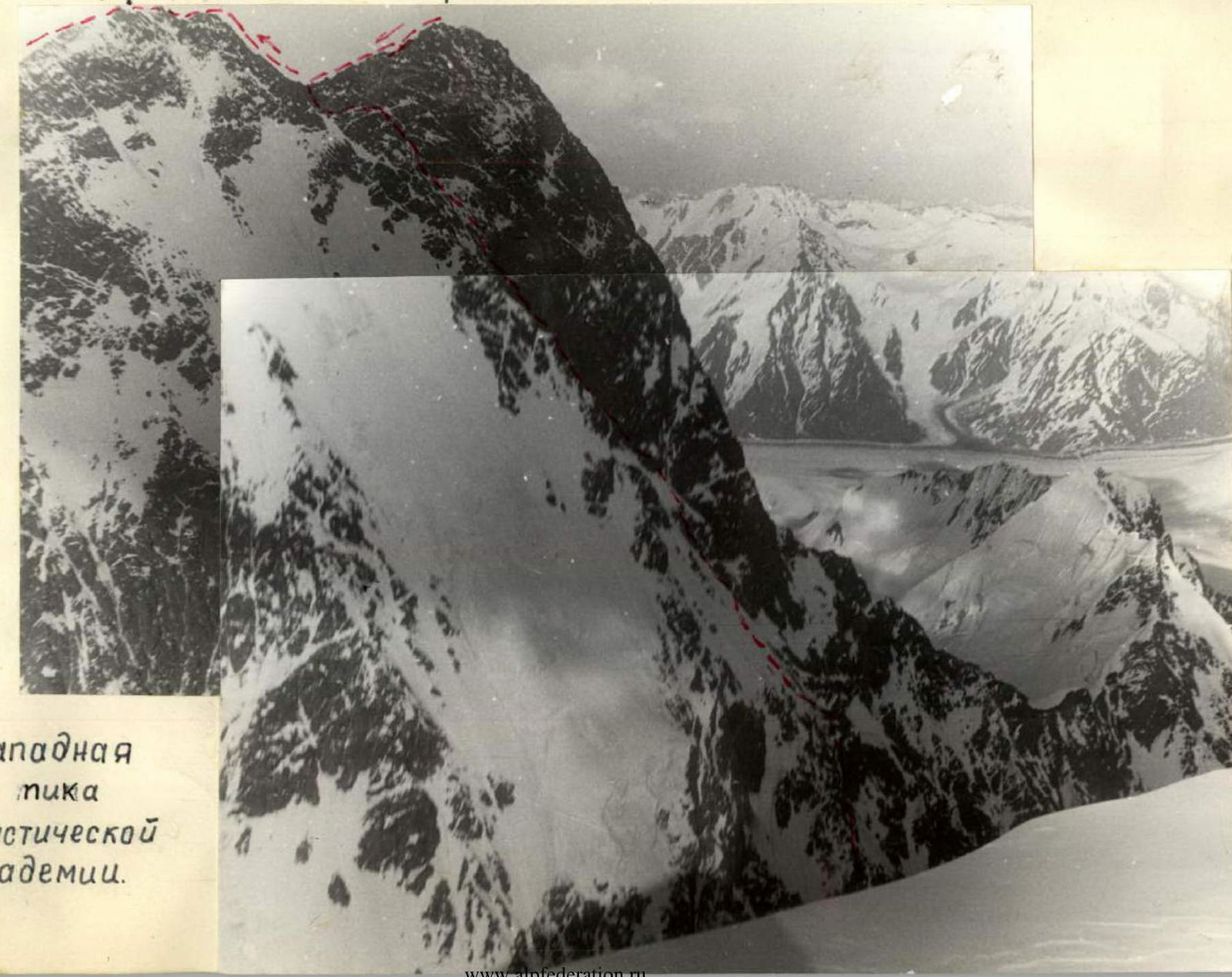
Section of the traverse — ridge and summit "6045 m" (R77–R81).
But sport is sport, and duty is duty. Our companions go down with Matyushin's group to assault camp № 2. The team remains in a composition of 5 people. The working day — 7 hours.
August 18. Until 12:00, the team rested. Equipment and food supplies were sorted out. Now the team consists of 2 ropes:
- NEKRASOV — STAROSELETS;
- VARDANYAN — AKHVLEDIANI — MASLENNIKOV.
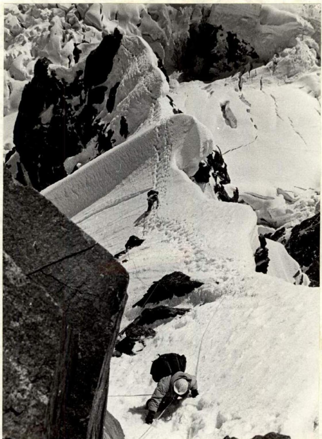
From the 5500 m col, a gentle ridge extends, curving in an arc and adjoining the northern ridge of "6045 m" peak. Since the year was very snowy, a mass of cornices formed on the ridge (section from the col), the reliability of which raised doubts. For safety reasons, the team decided to bypass the initial section of the ridge along the slope to the left (from the RGO glacier side) and exit onto the ridge at the point where it adjoins the northern ridge. In our opinion, this detour did not save time. Technically, both sections were equally challenging. The safety of passage in case of a detour was obvious. Since the ascent to the ridge goes from the east, it was decided that it would be safer in terms of avalanche danger in the second half of the day.
First, they descended 120 meters from the 5500 m col, then traversed about 300 meters to the right along the slope towards a characteristic gap in the ridge. After the traverse, the path went along a snow slope, first 30°, then 35°. To the right remained a characteristic drop of the glacier. The ascent to the gap went to the left along a firn slope, overcoming 2 bergschrunds. Then a traverse to the right and upwards, and the last 60 meters went along a steep slope. At 21:00, they set up a bivouac. The place for the bivouac was very good: a horizontal scree, water, and the absence of wind. The ridge towards the Bivachny glacier and Garmo peak was bounded by a rocky wall. They exchanged signal flares with the assault camp № 2. A control tour was set up.
The working day — 9 hours.
August 19. Departure from the bivouac site at 11:00. The northern ridge of "6045 m" peak is a wide (20–30 meters) ridge, the right edge of which consists of rocks, and to the left — snow or ice. During the ascent to the penultimate gendarme, they crossed an icy couloir (about 10 m) with step-cutting.
The ridge from the last gendarme to the summit has a cornice inclined towards Garmo peak. Here, movement was carried out with maximum caution. The exit to the summit of "6045 m" goes along a snowy, wide ridge. At 17:00, they reached the summit and set up a tour on the rocky outcrops. For the first time, people ascended this peak.
The descent from the summit to the 5700 m col, which leads to the eastern ridge of Garmo peak, took literally about 40 minutes.

First, they descended along the ascent route, then to the left and down, bypassing a crevasse on the left, and further to the right and down to the col. They set up a tent almost before the first cornice of the col.
Over two days, or rather one and a half, the section of the traverse between Komakademiya peak and Garmo peak was passed, and a nameless summit was conquered. But this section did not determine the complexity of the route. The team approached Garmo peak. If the first half of the traverse was determined by the wall of Komakademiya peak, the second half is determined only by Garmo peak. Garmo peak has no easy paths, and it was ascended only by four groups, one of which was part of a joint Soviet-British expedition. Garmo peak is a formidable peak. Among all the peaks, it stands out with its whiteness and height. The ridge simply overhangs the night camp. And the col represents continuous cornices. The weather is still good.
August 20. Departure from the bivouac site at 10:00.
- The col is a 250-meter ridge, jagged with 8 cornices.
- Complex snow-ice work.
- All cornices are inclined towards the RGO glacier.
- Overcoming the col took more than 4 hours.
After the col:
- First, a steep snowy ridge.
- Then a 5-meter ice wall.
- Firn gives way to soft snow.
- The snow is powdery and deep.
- Under the snow — ice.
- At some places, a climber sank waist-deep, and movement upwards simply stopped.
- At such sections, the lightest participant passed without a backpack.
- After the ice wall — a steep sharp ridge.
- Then another 5-meter ice wall.
- The team exits onto a "cushion".
According to the plan, the night camp was to be here, in the upper part of the "cushion" near the rocks.
- At 4 pm, it started snowing.
- The temperature dropped.
- By evening, a blizzard developed.
- The bivouac was on a good, comfortable site in a mixed mulde near the rocks.
- At night, it became even colder.
- 18 ropes were passed during the day.
The working day — 10 hours. A very difficult day. All 10 hours — ice and snow, and still at a low temperature. Despite fatigue, in the evening, in the tent, they held a small celebration in honor of Gogi Akhvlediani's birthday. Today, Gogi is 22 years old. As a gift, Gogi received a jar of black caviar. Feet began to freeze. Boots were placed in sleeping bags, and every day — a change of socks and insoles.
August 21. Departure from the bivouac site at 10:00. From the bivouac upwards, a very steep ascent of the rocky ridge begins. Many sections with flowstone. Complex work with careful piton insurance. This is one of the most difficult places. Then the steepness decreases, and cornices begin. The ridge ends with a narrow 15-meter col. A very complex section. The sharp ridge is cut down. The col abuts a second "cushion".
Along the "cushion", they move until the bergschrund, where the bivou


