REPORT
on the ascent of Peak Kom. Academii (6439 m) via the SW wall, category 6B (second ascent)
July 26 – August 4, 1979
Team of the Armed Forces of the USSR:
- Cherepov V.A. — leader
- Gaas A.V. — coach
- Gromko V.N.
- Egorov V.M.
- Zhak V.V.
- Maleev V.V.
- Sharonov B.P.
5. Table of main route characteristics
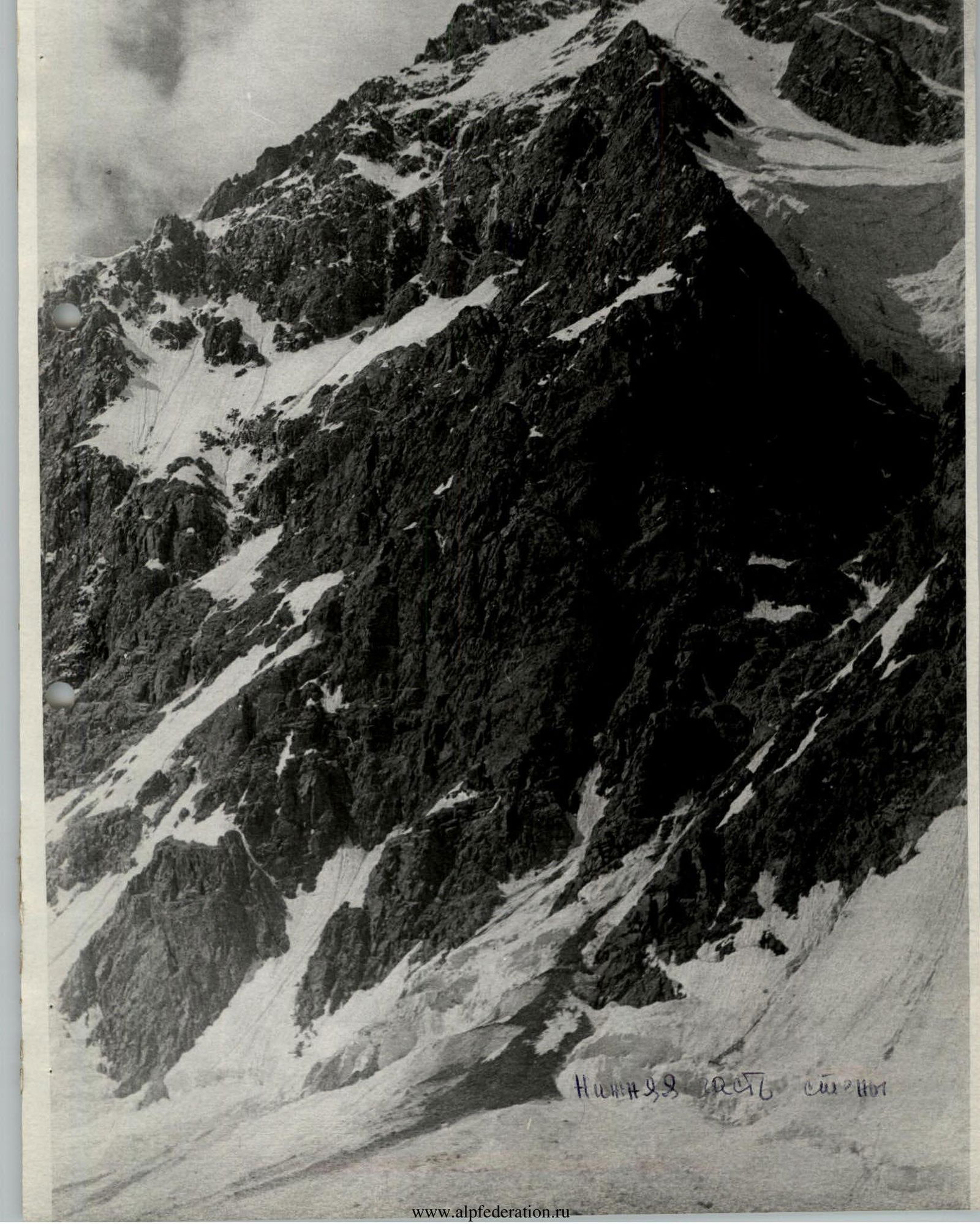
Route: Southwest wall of Peak Kom. Academii.
Elevation gain: From the glacier to the South summit over 2000 m vertically, including 1500–1600 m of technically difficult sections.
Average slope of the route: 64°/as assessed by the first ascensionists, ~70°. Average slope of the lower part of the wall: 70°. Average slope of the central tower: ~75°.
Pitons hammered: rock 168, ice 6.
Total hours of climbing: 67 h – to the South summit. To the North summit – an additional 7 h. Total: 74 h. Time does not include approach to the route.
Route length to the South summit – 2700 m.
| Date | Section | Slope | Length in 40 m pitches | Terrain characteristics | Time of bivouac | Climbing time | Rock pitons | Ice pitons |
|---|---|---|---|---|---|---|---|---|
| 28.07 | R0–R1 | 45° | 2 | snow-firn slope | 8:00 | 1 | – | |
| R1–R2 | 65–70° | 1 | chimney | 5 | – | |||
| R2–R3 | 65–70° | 1 | sheepbacks | 3 | – | |||
| R3–R4 | 55–60° | 0,5 | inclined shelf | – | – | |||
| R4–R5 | 65–70° | 1,5 | snow-covered rocks | 2 | – | |||
| R5–R6 | 80° | 1 | monolithic rock wall | 6 | – | |||
| R6–R7 | 85–90° | 1 | rock wall | 5 | – | |||
| R7–R8 | 80° | 0,5 | rock wall | 3 | – | |||
| R8–R9 | 55–60° | 0,5 | snowy ridge | – | – | |||
| R9–R10 | 90° | 1 | chimney with ice plug | 7 | 1 | |||
| R10–R11 | 70° | 2 | broken rocks with snow | 20:00 | 5 | – | ||
| 29.07 | R11–R12 | 65–70° | 2 | snow-covered broken rocks | 8:00 | 3 | – | |
| R12–R13 | 70–75° | 0,5 | rock shelf | 3 | – | |||
| R13–R14 | 85–90° | 1 | chimney | 5 | – | |||
| R14–R15 | 55–60° | 0,5 | rock ridge | 1 | – | |||
| R15–R16 | 70–80° | 1,5 | rock walls | 5 | – | |||
| R16–R17 | 80–85° | 0,3 | rock wall | 1 | – | |||
| R17–R18 | 65–70° | 1,5 | boundary of rocks and snow | 4 | – | |||
| R18–R19 | 80° | 0,8 | chimney | 20:00 | 6 | – | ||
| 30.07 | R19–R20* | 40–50° | 0,7 | rock cornice | 8:00 | 1 | – | |
| R20–R21* | 55–60° | 1 | sharp rock ridge | 1 | – | |||
| R21–R22 | 70–75° | 0,7 | narrow rock shelf | 1 | – | |||
| R22–R23 | 70–75° | 2,0 | “jendarme” | 7 | – | |||
| R23–R24 | 50–55° | 1 | broken rocks | 2 | – | |||
| R24–R25 | 60–65° | 2 | ice-firn slope | 2 | 3 | |||
| R25–R26 | 50° | 1 | sheepbacks | 20:00 | 1 | – | ||
| 31.07 | R26–R27* | 50–55° | 1 | sheepbacks | 7:00 | 2 | – | |
| R27–R28* | 50–55° | 5 | snowy-firn ridge “knife” | 9:30 | – | 4 | ||
| 1.08 | R28–R29 | 80° | 0,5 | rock wall | 5:00 | 1 | – | |
| R29–R30 | 75–80° | 0,75 | rock shelf | 1 | – | |||
| R30–R31 | 60–65° | 1 | snow-covered rocks | 4 | – | |||
| R31–R32 | 55–60° | 0,5 | snow-covered rocks | 1 | – | |||
| R32–R33 | 55–60° | 1,5 | snow-ice slope | – | – | |||
| R33–R34 | 75–80° | 2 | inclined shelf (left-up) | 8 | – | |||
| R34–R35 | 80° | 1 | rock wall | 9:30 | 5 | – | ||
| 2.08 | R35–R36 | 80–85° | 3 | boundary of rocks and snow | 6:30 | 11 | – | |
| R36–R37 | 75–80° | 2 | rock walls | 7 | – | |||
| R37–R38 | 65–70° | 0,5 | broken rocks | 1 | – | |||
| R38–R39 | 75–80° | 3 | monolithic rocks | 10 | – | |||
| R39–R40 | 70–75° | 0,25 | shelf | 2 | – | |||
| R40–R41 | 75–80° | 1 | chimney | 5 | – | |||
| R41–R42 | 80° | 0,25 | rock wall | 3 | – | |||
| R42–R43 | 60–65° | 4 | rock ridge | 20:00 | 6 | – | ||
| 3.08 | R43–R44 | 80–85° | 0,25 | rock wall | 7:30 | 1 | – | |
| R44–R45 | 55–60° | 1 | broken rocks | 1 | – | |||
| R45–R46 | 60–65° | 0,25 | inclined slab | 3 | – | |||
| R46–R47 | 55–60° | 0,5 | broken rocks | – | – | |||
| R47–R48 | 60–65° | 0,5 | sheepbacks | 1 | – | |||
| R48–R49 | 75–80° | 1 | Rock wall with shelf and inner angle | 4 | – | |||
| R49–R50 | 60–65° | 1 | broken rocks | 2 | – | |||
| R50–R51 | 55–60° | 0,7 | snow-covered rock shelf | 1 | – | |||
| R51–R52 | 65–70° | 0,5 | inclined slab | 2 | – | |||
| R52–R53 | 50–55° | 0,7 | sheepbacks | 1 | – | |||
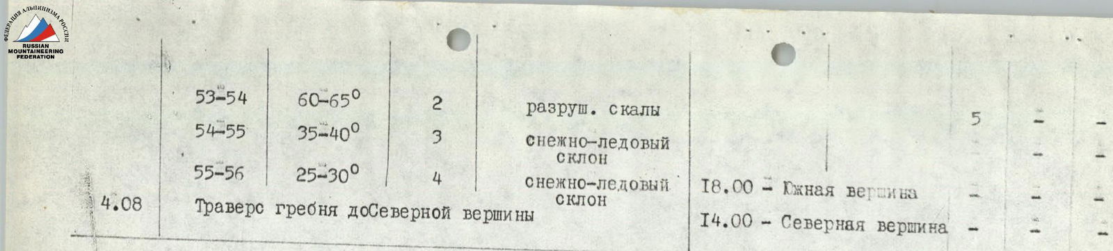
| R53–R54 | 60–65° | 2 | broken rocks | 5 | – | |||
| R54–R55 | 35–40° | 3 | snow-ice slope | – | – | |||
| R55–R56 | 25–30° | 4 | snow-ice slope | 16:00 – South summit | – | – | ||
| 4.08 | Traverse of ridge to North summit | 14:00 – North summit | – | – |
NOTE: *) Sections of the route processed the day before. On July 26, 1979, at 7:00, the team in full strength left the base camp for the upper reaches of the Vanch valley. Along the right-hand moraine (left orographically) of the Russian Geographical Society (RGO) glacier, the team approached the confluence of the Krasnoarmeets and RGO glaciers (4 h), where the army camps are located. This is a convenient location at the beginning of the green moraine, with a small lake. The observation group will be stationed here, and the SW wall of Peak Kom. Academii is visible from here.
July 27. At 9:00, the team continued on along the RGO glacier. They traversed the middle of the glacier under the wall of one of the small ridges extending from the ridge where Peak Kom. Academii is located. To the left of the waterfall descending from this ridge, where the glacier is close to the wall, the team ascended via a rope previously fixed during the reconnaissance sortie. They climbed a rocky outcrop and then moved along a steep snowy couloir. After ascending the couloir and crossing a small snowy ridge to the left of the couloir, they returned to the RGO glacier. They then bypassed numerous crevasses and séracs on the RGO glacier and approached the assault camp established during the reconnaissance sortie, near the SW wall of Peak Kom. Academii. From the army camps – 6–7 h. They set up a bivouac and continued observing the wall and the route, finalizing the start of the ascent and preparing equipment for the climb.
July 28. At 8:00, the rope team Cherepov – Zhak – Sharonov began processing the lower part of the wall. This section is an irregular rhombus. After overcoming the bergschrund, the team started ascending steep rocks (65–70°), following the left part of the rhombus (R1–R2). Piton protection was used. Further:
- a chimney was climbed left-upwards;
- then rocks resembling “sheepbacks” were traversed (R2–R3).
Ropes were fixed. The path continued roughly through the center of the rhombus, deviating to the right:
- along a snow-covered inclined shelf (R3–R4);
- then across rocks (R4–R5).
The rocks were diverse, snow-covered, and quite steep, but there were footholds for climbing. The steepness of the rocks increased (R5–R8). The walls included slabs with few footholds, but with cracks for pitons – ladders were used in such cases (R6–R7).
On the wall section (R7–R8), there was a small cornice (~1.5 m), which was bypassed left-upwards. Behind the ledge lay a section of difficult rocks 5–6 m high.
After the wall, a ridge (R8–R9) led to the upper part of the triangular wall. Here, a narrow chimney with a plug (R9–R10) was encountered. Climbing was difficult, and ladders were used. After the chimney, steep broken rocks of medium difficulty led to a small shelf (R10–R11), where a bivouac could be set up. This was also where the first ascensionists had camped, but they reached this spot after a day of route processing.
400 m were covered. Time: 15:00.
The rope team, having processed the lower part of the route, descended to the assault camp, from where a team of four started their ascent, to continue the climb the next day. By 20:00, the team Gaas, Gromko, Egorov, and Maleev had reached the shelf at the end of section R10–R11. The first camp on the wall was established here, with a tent suspended and a semi-reclined overnight stay organized.
July 29. 8:00. The first team to leave camp №1 was Gaas–Gromko. From the assault camp, the team Cherepov–Zhak–Sharonov ascended to camp №1. They climbed quickly and removed the ropes. They were assisted by the duo Egorov–Maleev, who then followed the first team. The weather was good, and there was a lot of work to be done, which would determine the speed of the entire team's progress. The last team worked very efficiently, quickly hammering pitons and handing over freed equipment to the preceding climbers. The leading team, like the day before, climbed without backpacks.
From camp №1, the initial movement was across broken rocks (R11–R12) with protection via outcrops and pitons. Then along an inclined shelf (R12–R13) to an overhanging wall (R13–R14), which was climbed via a narrow chimney with many loose rocks. Ladders were used during the climb. The lead climber wore galoshes.
The path continued along a counterfort with a snowy ridge (R14–R15), transitioning into monolithic rocks with small ledges. The overall steepness of the route increased.
Ahead lay a large “jendarme”. Initially, it was bypassed via narrow ledges on the right (R15–R16). Then a small steep wall (R16–R17) was encountered, climbed “head-on”, followed by a traverse along the boundary of rocks and snow (R17–R18). They reached a rock gully (chimney) with ice (R18–R19). The chimney led to a ridge. Climbing was difficult, with movement on fixed ropes and the use of ladders.
On a narrow rock ridge, after prolonged effort (2 h), a small platform for one tent for 3 people was created. Another tent was set up 160 m below on a narrow shelf – a semi-reclined overnight stay. On the same day, they processed another 80 m (R19–R21). The path above camp №2 also followed a narrow ridge, bypassing another “jendarme” on the right. The weather was good, with a temperature of –8°C at night.
July 30. 8:00. The team Gromko–Sharonov led the way. They traversed a narrow rock shelf (R21–R22), overcoming a “jendarme” (R22–R23), and continued along a sharp rock ridge. On this section:
- rocks were partly broken;
- climbing was difficult in places.
Then they ascended rocks (R23–R24) to an ice-firn slope (R24–R25), formed by a ridge and a small lateral ridge extending from it. The ice-firn slope was traversed in its lower part from left to right and upwards along the lateral ridge (R24–R25). Protection was provided using rock and ice pitons. Steps were cut. They reached a snowy ridge (R25–R26) with rock outcrops. At the beginning of this ridge:
- snow was cleared;
- a platform for two tents was prepared.
This took about 2 h. The tents were set up in the dark. The temperature was –10°C at night.
July 31. 7:00. The team Cherepov–Zhak climbed the rock section above the bivouac (R26–R27). They traversed a steep ice “knife” (R27–R28) – a ridge on an ice slope. Crampons were used, and ice pitons provided protection. The path lay to the left of a deep gully formed by falling rocks and ice.
The “knife” was about 200 m long to where it met the rocks. When V. Cherepov, who was leading, approached the upper part of the “knife”, rocks began to fall more frequently. The only safe shelter from them was above the “knife” (in ~150 m) under a rock wall. Time: 9:00. Passing this section could be unsafe, so it was decided to:
- fix ropes on the ice “knife” for 200 m on ice pitons;
- descend to the bivouac;
- continue the ascent the next morning.
The correctness of this decision became apparent within 1–1.5 h, when continuous rockfall started, lasting the rest of the day and most of the night. The left rope was partly covered by small avalanches. On this clear and sunny day, the team was forced to shelter for safety.
August 1. 5:00. Still dark, but the team quickly dismantled the camp and began the ascent via the ropes fixed the day before, which had to be dug out from under the snow that had frozen overnight. Everyone wore crampons. The last 10 m of the slope, remaining to reach the rocks where the ice gully had to be crossed, were climbed with the use of ice pitons and with extreme caution.
A small steep rock wall, led to by the ice “knife”, was climbed “head-on” (R28–R29).
The path continued along a narrow shelf to the right (R29–R30) to snow-covered rocks (R30–R32). The snow cover on the rocks gradually increased until the rocks were completely hidden under a snow-ice slope (R32–R33), leading to a steep wall under which one could safely shelter from falling rocks.
From here began the upper bastion – the central tower (R33–R56).
From under the wall, along an inclined shelf left-upwards, they climbed about 80 m of steep rocks to the next rock wall (R34–R35). Time: 9:30.
Finally, the most rockfall-prone sections of the route were behind them, and they had managed to pass them when the danger of rockfall was still relatively low. But like the day before, the sound of falling rocks gradually intensified today, especially from the left and below.
Again, like yesterday, the team decided to stop further movement and halted for a bivouac.
- Part of the team settled in different places on the shelf under the wall at the start of R33–R34.
- Another part – under the next wall at the start of R34–R35.
No tent was set up that day.
The day was sunny and hot, with significant snowmelt, water flowing down the wall, and occasional icicles, ice fragments, and rocks falling.
The temperature was –10°C at night.
August 2. 6:30. Early rise. The team Gromko–Cherepov led the way. They climbed steep rocks with good holds (R35–R36), along gullies where water was flowing. Climbing was difficult, and they moved without backpacks. Gradually, the steepness of the wall decreased, and the structure of the wall changed: from monolithic to blocky (R36–R37). Five pitches were climbed, and the team Cherepov–Maleev took the lead. The path followed broken rocks (R37–R38). Climbing here required extreme caution due to the danger of dislodging rocks onto climbers below. Then they encountered steep rocks again with diverse terrain (R38–R39). Ladders were used in some places. After passing a narrow inclined shelf (R39–R40) and a steep chimney (R40–R41), they approached the start of a small steep wall (R41–R42). Here, the lead changed again. V. Zhak took the lead, assisted by V. Cherepov. They climbed a rock ridge (R42–R43).
This day was characterized by significant physical exertion. Early rise, long working day, large elevation gain, increased altitude (~6000 m), and heavy backpacks (the first duo still worked without backpacks). All this required serious physical and psychological strain from the participants.
After climbing the rock wall (R41–R42), the terrain became less steep and acquired a ridge-like character (R42–R43), but there was still no suitable place to set up even one tent. On steep and small shelves lay fine and medium scree, which came loose at the slightest touch. Time: around 20:00. The working day lasted more than 13 h. After processing a small rock wall (R43–R44), they stopped for a bivouac. Again, the team failed to gather together for the night; everyone spent the night apart. The weather was good. In the second half of the night, a strong wind arose, which subsided somewhat by morning.
August 3. 7:30. The team Sharonov–Maleev started moving. After ascending the ropes fixed the day before along the rock wall and passing section (R44–R45), they climbed a small slab (R45–R46) and then traversed rocks consisting of loose stones (R46–R47) and “sheepbacks” (R47–R48), where water began to flow.
The proximity of the summit was felt. However, the rocks became steeper again, and another wall (R48–R49) was encountered. It was climbed along a narrow inclined shelf right-upwards to an inner corner. Climbing was difficult, with the lead climber ascending without a backpack. The inner corner led to a small rock shelf with many loose stones. Further, a rock wall consisting of large white blocks, down which water flowed (R49–R50). Along a rock shelf below the largest block – a traverse to the right. Then, overcoming rock slabs (R51–R52), “sheepbacks” (R52–R53), and broken rocks (R53–R54), they reached a gentle ice slope with rock outcrops (R54–R55). Apparently, here, on sections (R53–R54) and (R54–R55), rockfall originated. Clouds appeared. The approach of bad weather was felt. The wind strengthened.
Along the snow-ice slope (R54–R55), adhering to the rock ridge on its left side, they climbed higher. Large “jendarmes” were encountered on the way, each seeming like the summit. The ridge had a wavy character. After overcoming the last snow-ice slope (R55–R56), at 16:00, they reached the South summit of Peak Kom. Academii.
In the cairn, they found a note from the team of the Novosibirsk GorSportkomitet led by Kaspirovich from 1975. They examined the path towards the North summit and decided to stop for the night practically on the summit, descending 10 m into one of the depressions in the ridge.
They began preparing a platform for tents:
- by clearing a large amount of ice;
- creating excellent platforms for two tents, which they set up side by side.
This took more than an hour. Finally, for the second time during the entire ascent, the entire team gathered together for the night. A strong wind blew all night, with snowfall.
August 4. In the morning, the weather was very bad, with snowfall and limited visibility. By 9:00, the snow had stopped, and visibility improved. They set off at 9:15. They moved along the ridge towards the North summit. The path was relatively easy, with small “jendarmes” climbed head-on. The largest “jendarme” on the ridge was bypassed on the left, with piton protection. The rock ridge ended in a wall, from which they organized a rappel descent. After the descent, the path continued along a snow-ice ridge with a wavy character. The ridge had cornices facing northeast. Along the ridge, they approached a saddle, from where a snowy ascent began, gradually transitioning into a rocky one.
They ascended broken rocks on the ascent to a “jendarme”, which was climbed initially head-on and then with a deviation to the left. After the “jendarme”, they overcame a small rock wall and continued the ascent along broken, gentle rocks to the North summit of Peak Kom. Academii. At 14:00 – on the North summit.
At 14:30, they began their descent towards the RGO pass (Otrada), then to the RGO glacier, and back to the base camp. During the descent from the North summit, they had to use ice screws and set up sports descents repeatedly. The slope was steep, with a thin (3–5 cm) layer of snow on the ice. The last person descended wearing crampons. The weather was unstable, with wind and occasional snowfall.
From the pass, they descended to the RGO glacier along a rock ridge (7 sports descents). Further, the path to the base camp followed the glacier along the Category III wall of Peak Kom. Academii. The wall was shrouded in clouds, with only the beginning of the route visible. Under the wall – traces of recent rockfall, as well as snow and ice deposits, but dark colors prevailed.
7. Assessment of participants' actions
During the ascent, all participants performed well, although for three of them (V. Egorov, V. Zhak, B. Maleev), this was their first “six”. This trio was also on a height close to 6500 m for the first time. All participants were physically and technically well-prepared for such a serious ascent, enduring:
- cold;
- discomfort of sitting overnight stays;
- the organization of which took a considerable amount of effort and time.
The team's work was friendly, clear, and well-coordinated. Much initiative and high activity were shown by the team veteran and ascent leader V. Cherepov, as well as the youngest participant – V. Zhak.