on the ascent of Peak Kommunisticheskoy Akademii (6439 m) via the northwest edge, accomplished from August 3 to 16, 1972, during the USSR Armed Forces Championship in mountaineering.
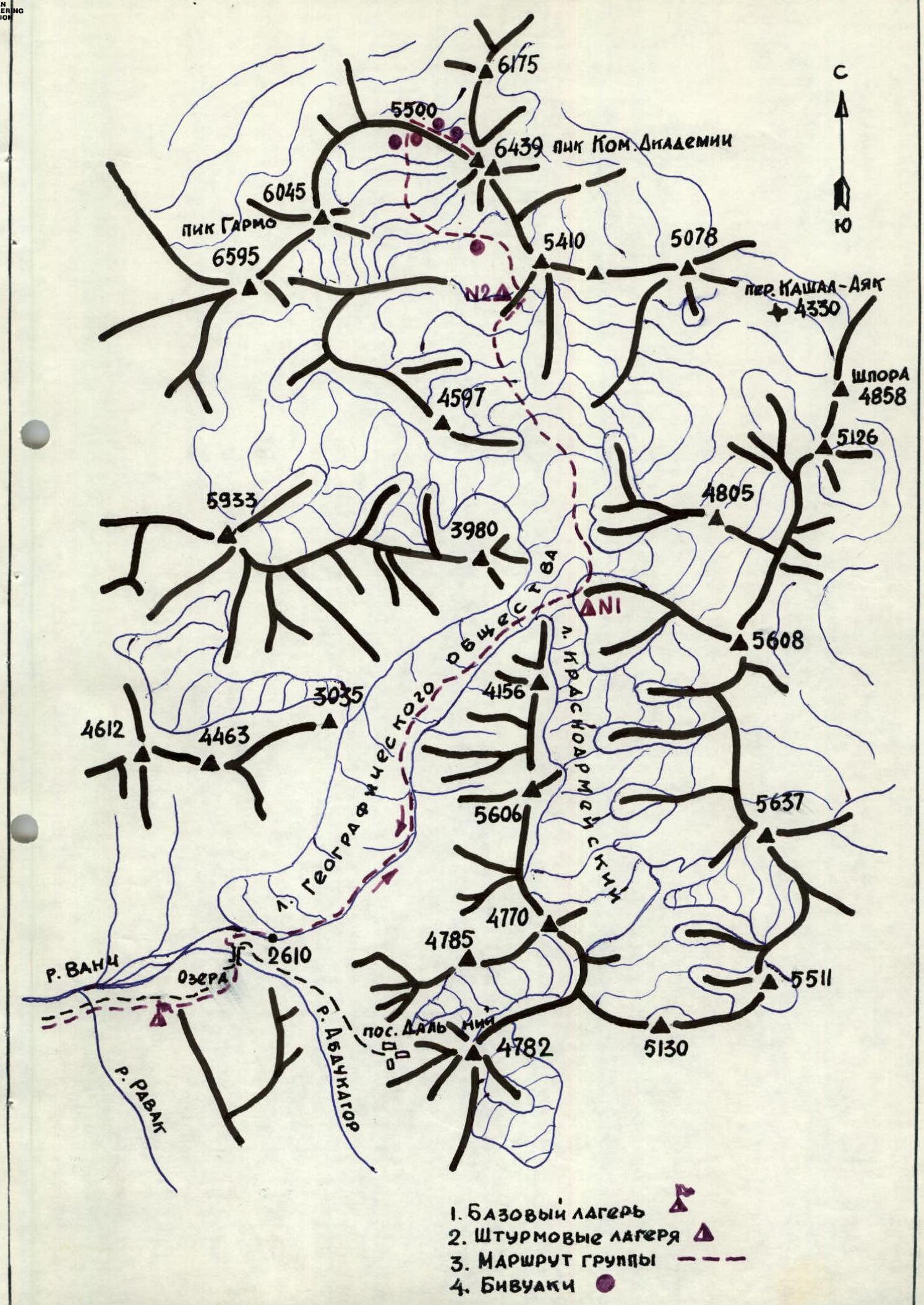
Peak Kommunisticheskoy Akademii (6439 m) is located in the Central Pamir, in the southwestern part of the Fedchenko Range, adjacent to the Academy of Sciences Range near Peak Garmo. To the north and northwest, the upper reaches of the Bivachny Glacier adjoin the base of Peak Kommunisticheskoy Akademii, while its southern slopes feed the right tributary of the Geographical Society Glacier. The eastern and northeastern slopes contribute to the formation of the twin-headed Koma-Akademii Glacier, which flows into the Fedchenko Glacier near a high-altitude weather station.
The first ascent to the South Summit of Peak Koma-Akademii was made via the northeast face in 1965 by a team from the Union of Sports Societies and Organizations of the Uzbek SSR, led by A. P'yankov. In 1971, a team from the USSR Armed Forces mountaineering training camp, led by A. Bitny, repeated the ascent, reaching the north summit via the south summit and the southeast face.
During the 1972 season, the base camp for the USSR Armed Forces mountaineers was established on July 25, 85 km from the town of Vanch, near the Geographical Society Glacier, at an altitude of 2600 m. The area of the planned ascents was well-studied during the 1971 USSR Armed Forces training camp, allowing all participants to immediately begin training climbs in the high-altitude zone.
From July 27 to 31, all team members:
- participated in setting up assault camps #1 and #2;
- conducted thorough reconnaissance and reviewed the planned ascent routes;
- made necessary supplies of food and equipment;
- underwent active acclimatization at altitudes of 4200–5000 m.
After thorough reconnaissance and discussions, the team decided on the final ascent route: the northwest edge of Peak Koma-Akademii from the 5500 m col between Peak Garmo (6045 m) and Peak Koma-Akademii, approaching from the Geographical Society Glacier.
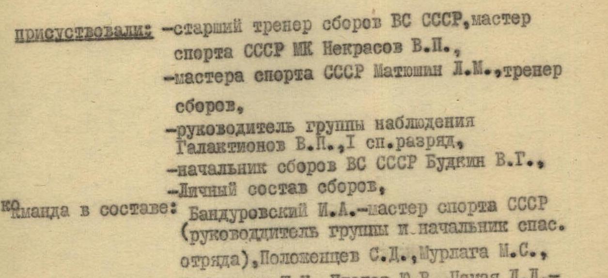
The coaching council approved the team composition and the planned route.
Team composition:
- I. Bandurovsky, Master of Sports, USSR, team captain.
- S.D. Polozhentsev, 1st sports category, deputy team captain.
- M.S. Murlaga, 1st sports category.
- Sh.N. Gabisiani, 1st sports category.
- Yu.V. Platov, 1st sports category.
- D.D. Tsomaya, 1st sports category.
Team coach: V.P. Nekrasov, Master of Sports, USSR, international class.
After a 3-day rest, the team began the assault. August 3. Departure from base camp at 6:00 AM. The route followed the path to the settlement of Dal'ny, crossing the Abdukator River via a suspension bridge, and then along the trail to the tongue of the Geographical Society Glacier on its right side. The team continued along the right side of the glacier to the confluence with the Krasnoarmeysky Glacier. They bivouacked (1st assault camp) in a moraine pocket near a lake, on a grassy clearing. Time from base camp: 8 hours.
August 4. Departure at 6:00 AM. The team ascended the Geographical Society Glacier, traversing towards the rocky ridge descending from Peak 5410. They navigated through an icefall (crevasses, icefalls, belays!), staying to the right, until reaching the start of a couloir descending from the ridge. After crossing a bergschrund, they ascended a vertical, smooth wall (35–40 m) to a talus shelf (belays). They then moved left along the shelf to a snowy couloir (35–45°, 20 ropes) and ascended to a horizontal part of the ridge. Biwak or 2nd assault camp. Time from 1st assault camp: 7 hours.
August 5–6. The team remained at the 2nd assault camp, observing and coordinating with groups led by V.P. Nekrasov and L.M. Matyushin. On August 6, the weather deteriorated significantly, with complete calm, snow, and rain.
August 7. Departure at 9:30 AM. The team continued ascending the glacier towards Peak Koma-Akademii, traversing the slopes of Peak 5410 (rocks!) to the ridge at the start of the second icefall. They ascended the ridge (1.5–2 ropes, belays!) and then transitioned to the upper right part of the icefall, reaching a plateau below Peak Koma-Akademii (crevasses, belays!). The weather worsened again. They set up a biwak and encountered teams ascending the southwest face. Time from 2nd assault camp: 3 hours.
August 8. Departure at 11:00 AM. By this time, the snow had stopped, and the fog had cleared. From the biwak, they traversed a gentle glacier towards the third icefall. Staying in the middle of the glacier, they navigated through the icefall (crevasses, icefalls, belays!). Overcoming the icefall required the full range of snow and ice techniques. When approaching the icefall, particular attention was given to the hanging glaciers on the slopes of Peaks 6045 m and Koma-Akademii. After the icefall, they reached a snowy plateau and followed it to the col between Peak Garmo (6045 m) and Peak Koma-Akademii. They set up a biwak on the plateau below the col. Time from biwak under the walls of Peak Koma-Akademii: 9 hours.
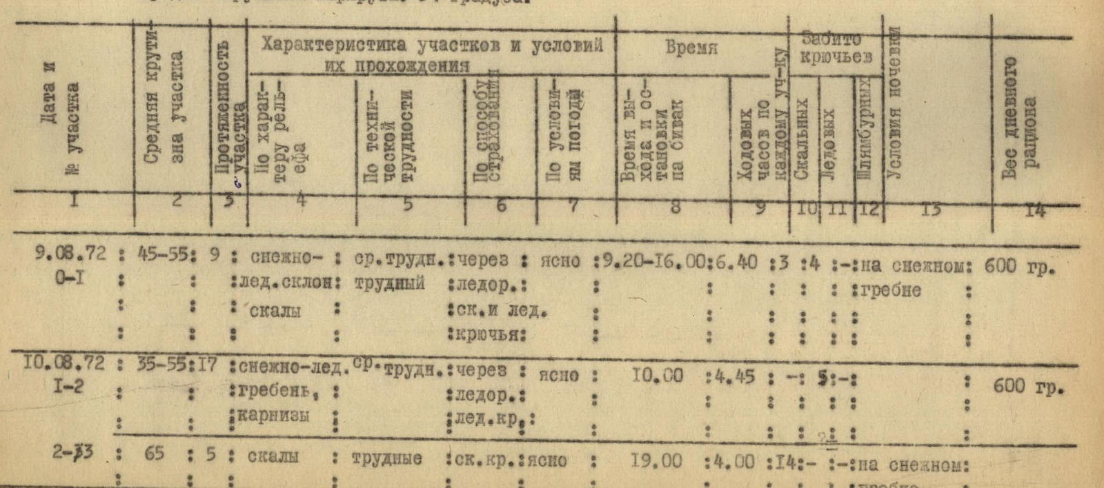
August 9. (Section 0-1). Departure at 9:20 AM. They ascended to the 5500 m col towards the first rocky pillar to the right of the col. This was the most optimal and safe ascent route. They climbed 2 ropes up a snowy slope (45°, belays!) to a bergschrund, then crossed it to a snow-ice slope and ascended 3 ropes (50–55°, belays!) to rocks. They climbed difficult, steep rocks (65–70°, belays!) for 4 ropes to a snowy ridge. The col. They leveled a platform for a tent on the snowy ridge. Time from biwak on the plateau below the col: 6 hours 40 minutes.
August 10. (Section 1-2). Departure at 10:00 AM. The route followed a snowy ridge, partially icy (35–55°, 17 ropes, belays!), with steep snow-ice drops to the north and almost vertical rock walls to the south. At the end of the ridge, they encountered a 150-meter pillar (section 2-3), which was overcome directly via difficult, smooth, "tile-like" rocks (65°, belays!), spanning 5 ropes. They descended from the pillar to a snowy ridge. Biwak. Time from biwak on the col: 8 hours 45 minutes.
August 11. (Section 3-4). Departure at 9:00 AM. They ascended a snow-ice slope (55–60°, belays!) for 3 ropes to rocks. They climbed very difficult, snow-covered, and icy rocks (60–75°, belays!) directly upwards for 4 ropes (section 4-5) to a rocky ledge. Biwak on the ledge. Time from biwak on the ridge below the pillar: 8 hours 35 minutes.
August 12. (Section 5-6). They ascended a difficult wall with few holds (80°, belays!) for 1.5 ropes to a rocky ridge. Along the sharp and difficult (65°, belays!) ridge for 0.5 ropes, they reached a pre-summit snow-ice slope. They ascended the slope (section 6-7) for 18 ropes (35–50°, belays!) to a rocky tower on the north summit of Peak Koma-Akademii. Rocks of moderate difficulty (section 7-8), with a slope of 50° and spanning 6 ropes, led them left-upwards to talus and then to the summit. The summit is a sharp rocky peak. Time from biwak on the rocky ledge: 7 hours 45 minutes.
They reached the summit at 15:55. They found a note from the USSR Armed Forces mountaineering team led by A.V. Bitny, dated August 17, 1971.
The descent from the summit followed the ascent route:
- August 12. North summit of Peak Koma-Akademii (6439 m) to biwak on the rocky ledge. Time taken: 4 hours 50 minutes.
- August 13. Biwak on the rocky ledge to the col. Time taken: 8 hours.
- August 14. Rest day due to coordination requirements on the col, observing other groups.
- August 15. Col to 2nd assault camp to 1st assault camp. Time taken: 10 hours.
- August 16. 1st assault camp to base camp. Time taken: 6 hours.
Characteristics of the ascent route via the northwest edge of Peak Koma-Akademii:
- The route is combined, featuring complex snow-ice and rocky sections, requiring thorough preparation and appropriate equipment.
- The route has significant snowfall. Crossing snowy sections is safest during early morning or late afternoon, depending on the exposure and steepness.
- The route is 80% narrow-ridged, with an average steepness of 54°. The edge is flanked by steep slopes of up to 60–70° and sometimes 80°. The route is characterized by numerous snow cornice.
- The optimal group size is 10–15 people. Setting up biwaks is possible along most of the route, except for rocky sections, but requires significant time and physical effort.
- The route via the northwest edge is only passable in good weather. The section from the 5500 m col to the north summit, as well as the approaches to the col and the ascent to it, can be entirely icy in snow-free years.
- When traversing the glacier under the slopes of Peaks 6045 m and Koma-Akademii, caution is required due to potential icefalls from their slopes.
- The best time for the ascent is late July to August, based on data from the Fedchenko Glacier weather station.
- Given the snowy nature of the route, preparation should include insulated mountaineering boots, spare gloves, and socks.
- The complexity of the route demands high technical, physical, and psychological preparation.
- Time taken: a) From base camp to the 5500 m col: 27 hours. b) Ascent to the col and traversal of the northwest edge to the summit: 31 hours 25 minutes. c) Total time from base camp to the summit: 58 hours 25 minutes. d) Descent from the summit to base camp: 29 hours.
Conclusions:
- The tactical plan and biwak locations, determined by preliminary observations, were correct.
- The equipment and food supplies were optimal and fully supported the ascent.
- The route to Peak Koma-Akademii via the northwest edge is undoubtedly complex and maximally logical, objectively safe. Compared to routes like the southeast face, 5B category of difficulty, they are comparable in complexity but longer.
- The team ascended via a new route, adhering to the tactical plan, under observation, and fulfilling all coordination and communication requirements. The ascent was conducted without violating USSR mountaineering rules or the 1972 USSR Armed Forces Alpine Championship regulations.
- Team members I.A. Bandurovsky, S.D. Polozhentsev, M.S. Murlaga, and Sh.N. Gabisiani demonstrated high technical proficiency, tactical awareness, and coordination, completing the route at a good pace without incidents.
- Yu.V. Platov and D.D. Tsomaya personally opted out of the ascent due to poor health but contributed significantly to the overall success.
Captain of the team: I. Bandurovsky Coach of the team: V. Nekrasov
Table
Key characteristics of the ascent route:
- Route: Peak Kommunisticheskoy Akademii (6439 m) via the northwest edge.
- Height gain: 1309 m.
- Number of difficult sections: 4.
- Average steepness of the route: 54°.
Information by days:
-
August 9, 1972 (Section 0-1)
- Average steepness: 45–55°
- Length: 9 ropes
- Characteristics: snow-ice slope, medium difficulty, via ice axe, clear, rocks, rock and ice pitons
- Time: start 9:20, end 16:00, moving time 6 hours 40 minutes
- Pitons used: 3 rock, 4 ice
- Bivouac conditions: on snowy ridge
- Daily ration weight: 600 grams
-
August 10, 1972 (Section 1-2)
- Average steepness: 35–55°
- Length: 17 ropes
- Characteristics: snow-ice ridge, medium difficulty, via ice axe, clear, cornices, ice pitons
- Time: start 10:00, moving time 4 hours 45 minutes
- Pitons used: -
- Bivouac conditions: -
- Daily ration weight: 600 grams
-
August 10, 1972 (Section 2-3)
- Average steepness: 65°
- Length: 5 ropes
- Characteristics: rocks, difficult, rock pitons, clear
- Time: start 19:00, moving time 4 hours
- Pitons used: 14 rock
- Bivouac conditions: on snowy ridge
- Daily ration weight: -
-
August 11, 1972 (Section 3-4)
- Average steepness: 55–60°
- Length: 3 ropes
- Characteristics: snow-ice slope, medium difficulty, via ice axe (strong), clear, ice pitons, wind, and frost
- Time: start 9:00, moving time 2 hours 10 minutes
- Pitons used: 3
- Bivouac conditions: -
- Daily ration weight: 600 grams
-
August 11, 1972 (Section 4-5)
- Average steepness: 60–75°
- Length: 4 ropes
- Characteristics: snow-covered rocks, very difficult, icy, clear
- Time: start 17:35, moving time 6 hours 25 minutes
- Pitons used: 19
- Bivouac conditions: on rocky ledge
- Daily ration weight: -
-
August 12, 1972 (Section 5-6)
- Average steepness: 65–80°
- Length: 2 ropes
- Characteristics: rocky wall, difficult, rock pitons, frost, clear
- Time: start 8:50, moving time 2 hours 15 minutes
- Pitons used: 9
- Bivouac conditions: -
- Daily ration weight: 600 grams
-
August 12, 1972 (Section 6-7)
- Average steepness: 35–50°
- Length: 18 ropes
- Characteristics: snow-ice slope, medium difficulty, via ice axe, clear, ice pitons
- Time: moving time 3 hours 50 minutes
- Pitons used: 7
- Bivouac conditions: -
- Daily ration weight: -
-
August 12, 1972 (Section 7-8)
- Average steepness: 50°
- Length: 6 ropes
- Characteristics: rocks, medium difficulty, via rock pitons, frost, clear
- Time: moving time 1 hour 40 minutes
- Pitons used: 6
- Bivouac conditions: -
- Daily ration weight: -
Summit of Peak Koma-Akademii (6439 m) reached at 15:55. Descent from the summit followed the ascent route.
Total:
- Steepness: 54°
- Ropes: 64
- Time: 31 hours 25 minutes
- Pitons used: 51
- Daily ration weight: 19 (units not specified)
Captain of the team: I. Bandurovsky Coach of the team: V. Nekrasov
Protocol
of the debriefing of the USSR Armed Forces mountaineering team ascent to Peak Kommunisticheskoy Akademii (6439 m) via the northwest edge, accomplished from August 3 to 16, 1972, during the USSR Armed Forces Alpine Championship.
Speakers:
I.A. Bandurovsky – outlined the chosen tactical plan and its justification, characterizing the route to the summit via the northwest edge.
The route is largely objectively safe and represents complex rock-snow-ice work. The ascent confirmed that the planned tactical plan, chosen path, and biwak locations, determined by preliminary observations, were correct. The route complexity is assessed as 5B category.
The equipment and food supplies were optimal and fully supported the ascent.
Comparison with routes like the southeast face of Chatyn-Tau (5B category), the north face of the 2nd western summit of Tutyu-Bashi (5B category), and others, shows that the route is comparable in complexity but longer.
The team, consisting of I.A. Bandurovsky, S.D. Polozhentsev, M.S. Murlaga, and Sh.N. Gabisiani, executed the route clearly and cohesively, at a good pace, without incidents.
Due to poor health, team members D.D. Tsomaya and Yu.V. Platov did not complete the ascent but actively participated in observing other groups.
M.S. Murlaga – the route is logical and interesting, very complex, and requires full mobilization of mountaineering skills. It is the most complex of all the peaks I have ascended. The route was completed without failures or incidents and fully deserves the 5B category.
Sh.N. Gabisi - noted the increased complexity of the route, requiring heightened attention and tension. Of the nine peaks of the 5th category I have ascended, this is the most complex and is classified as 5B category. The route is logical and sufficiently safe.
V.S. Galaktionov – the team acted in accordance with the tactical plan, constantly under observation, and precisely fulfilled coordination requirements.
L.M. Matyushin – the team completed the ascent in full compliance with USSR mountaineering rules and the 1972 USSR Armed Forces Alpine Championship requirements. The route is undoubtedly complex and logical and can be classified as 5B category.
V.P. Nekrasov – noted the high technical proficiency of the team that reached the summit. The route is logical, of great interest, and belongs to the 5B category.
Debriefing conclusion:
- The ascent was completed without violating USSR mountaineering rules or the 1972 USSR Armed Forces Alpine Championship regulations and can be credited to: – I.A. Bandurovsky – S.D. Polozhentsev – M.S. Murlaga – Sh.N. Gabisi
- The route should be submitted to the classification commission for categorization.
- The ascent report should be submitted to the Main Judging Collegium of the 1972 USSR Armed Forces Alpine Championship.
Senior coach of the team, Master of Sports, USSR, international class V. Nekrasov
Protocol led by participant of the 1972 USSR Armed Forces mountaineering training camp S. Polozhentsev
August 25, 1972