Ascent to Pik Izvestii from Walter Glacier via the north spur
The first ascent was made by the "Pamir-77" team — led by Cherny N.D. Pik Izvestii is located in the central part of the Pamir Mountains, in the Academy of Sciences Range, between Pik 6700 and Voroshilov Peak. The height of Pik Izvestii is 6840 m. To the north lies the Walter Glacier, and to the south lies the Stalin Glacier. Until now, no routes had been made from Walter Glacier directly to the summit of Pik Izvestii. The route taken represents a snow-ice spur, starting with a straightforward ridge section from Walter Glacier. The spur leads to the firn fields adjacent to the summit of Pik Izvestii. The ascent was made from a base camp by a lake at the confluence of the Moskvina and Walter Glaciers by a team of trainers from "Pamir-77" in the following composition:
- Cherny N.D., CMS — leader
- Borodkin Yu.V., MS
- Bobrov V.I., CMS
- Smirnov R.N., MS
The team had good prior acclimatization: ascent to Pik Petrovskogo, ascent up the same spur of Pik Izvestii to 6100 m (from where the team was withdrawn for rescue work) and participation in rescue work on Pik E. Korzhenevskoi with ascent to 5600 m.
Day 1
From the base camp by the lake at the confluence of the Moskvina and Walter Glaciers, the team departed on August 3, 1977, at 6:00. Moving along the right (orographic) moraine of Walter Glacier, the team reached the upper cirque of this glacier in 3 hours, crossed the glacier, and approached the base of the spur.
The lower part of the spur (sections R0–R1, R1–R2) is a scree ridge turning into straightforward rock. It took the team 1 hour to overcome it.
At the end of the ridge, there is a good resting and camping spot.
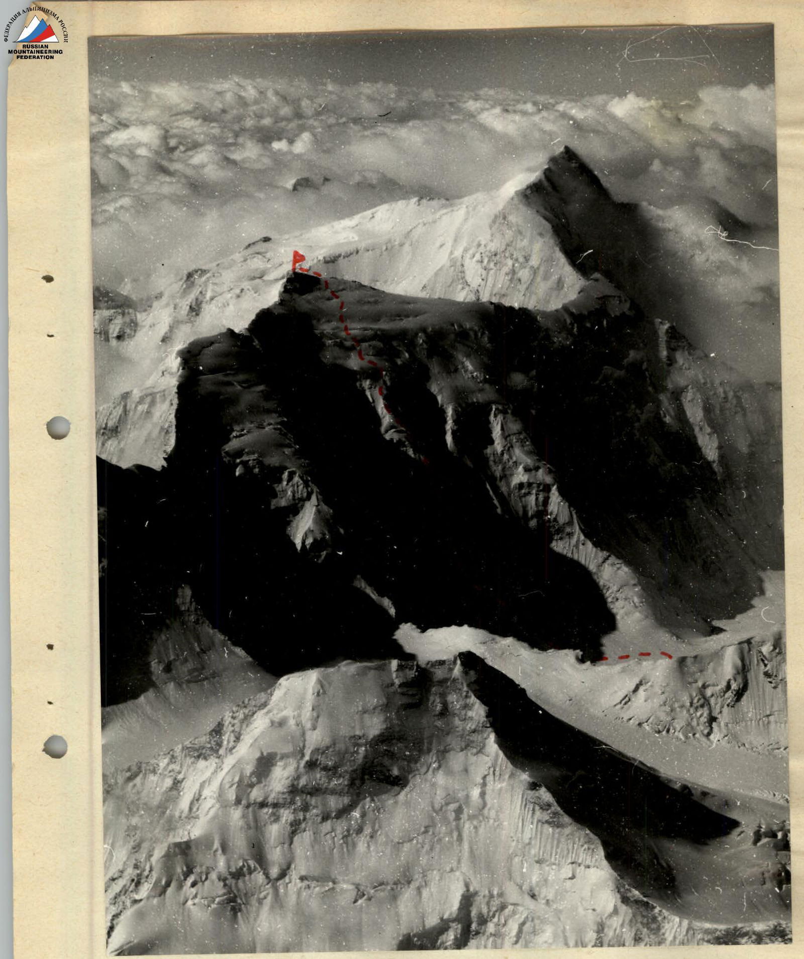
Pik Izvestii, view from the north, photo taken from an airplane. — Team's route.
From here begins a snow-ice ridge leading to the first ice slope. In its lower part, the ridge is gentle at 10–20°, but its steepness increases to 40° in the upper part. Depending on weather conditions, there may be more or less ice, but movement across it is still done in crampons with protection via ice axe and ice screws.
The bypass of the first ice slope (section R3–R4) is done on the right by traversing steep ice. This section is the most challenging on the route. It represents an ice slope with an average steepness of 40° ( местами до 60°). In places, the ice is rotten, and the protection is screw belays. Most of this section required step-cutting. It is recommended to pass this section in the first half of the day when it is still in the shade, as icefall is possible in principle. Passing this section took about 3 hours. Further, the route lies across a broad snow-ice spur with individual ridges, hollows, and ice walls. In places, the spur is intersected by crevasses. Movement is mostly alternating. Protection is via ice axe, and in places, ice screws. Having moved about 200 m along it, the team set up camp in a convenient snow hollow.
Day 2
On this day, the team continued moving along the snow-ice spur. The team departed from the camp at 8:00 and, with a short break for a snack, moved until 17:00, approaching the upper firn slope by evening. Here, at a height of about 6200 m, on a snow slope, a platform was cut out for a tent. In the evening, the pair Borodkin — Cherny:
- trod paths in the lower part of the snow-firn slope
- to facilitate the ascent up it in the morning.
The snow condition was satisfactory.
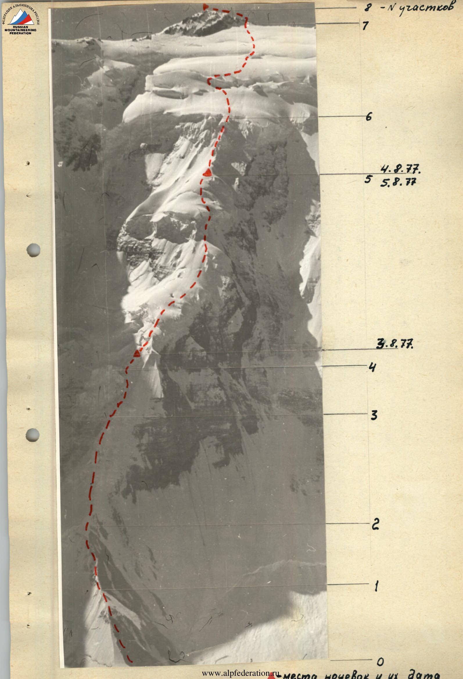
Day 3
Leaving the tent and backpacks at the campsite, the team went up lightly to ascend to the summit and descend back to camp in one day. The lower part of the snow-firn slope was traversed along partially snow-covered tracks made the previous day. In the upper part of the slope, the steepness reaches 45–50°, but in the morning (the team departed at 7:30), the firn held well. Movement was alternating, with protection via ice axe. The upper part of the slope can be passed in two ways: either across a 3-meter firn wall, where it would likely be necessary to make a diagonal cut, or along a steep gully (up to 50–60°) with deep snow, leading to a bypass of this wall to the lower edge of the pre-summit firn fields of Pik Izvestii. The team chose the second option. The gully was technically climbed by Borodkin, and the rest of the team followed using a fixed rope.
The further path lies across firn fields descending from the summit ridge of Pik Izvestii. The lower part is gentle, and the snow was not very deep, so the team moved simultaneously. The middle part of the fields is cut by slopes and crevasses, and here, in places, it was necessary to:
- organize protection via ice axe,
- overcome steep snow-ice ascents up to 40–50°.
The upper part of the fields is also relatively calm. After reaching the snow-covered rocky ridge of the summit, the team moved along it to the left and was on the summit by 17:00. The descent along the ascent route to the camp at 6200 m took 3 hours, and by 20:00, the team was back at the tent. It should be noted that under less favorable conditions (bad weather, deep snow) or with poorer physical preparation, the team might not have made it to the summit and back in one day. Therefore, it is advisable to set up the last camp above the firn slope at a height of 6400–6500 m.
Day 4
The team continued descending along the ascent route. On challenging ice sections, 4 ice screws were left, through which sport rappels were organized with subsequent rope retrieval. In places, ice pillars were cut out for the same purpose (a total of 3 such pillars were cut). By 14:00, the team descended to Walter Glacier, and by 18:00, they approached the base camp.
List of equipment used
- High-altitude tent — 1 pc.
- Main rope — 2×40 m.
- Auxiliary rope — 60 m.
- Ice screws — 8 pcs.
- "Febus" primus — 1 pc.
- Ice axes — 2 pcs.
- Ice hammers — 2 pcs.
- Personal equipment — 4 sets.
Recommended number of participants — 4–6 people.
Conclusion
Assessing the route taken and comparing it with nearby routes by Borodkin, Cherny on Pik Kommunizma, and the route by Budanova on Pik E. Korzhenevskoi, the team evaluates it as category 5B difficulty.
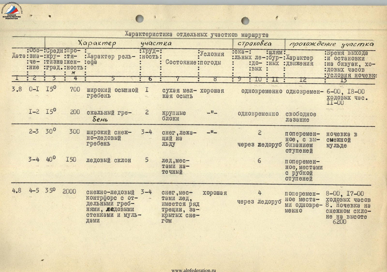
Characteristics of individual sections of the route
| № | Date | Section | Steepness | Length | Nature of terrain | Category of section | Condition / Conditions | Protection | Nature of movement | Notes |
|---|---|---|---|---|---|---|---|---|---|---|
| 1 | 3.08 | R0–R1 | 15° | 700 m | broad scree ridge | 1 | dry fine scree / good | simultaneous | simultaneous | 6:00, 18:00, 11 hours walking time |
| 2 | R1–R2 | 15° | 200 m | rocky ridge | 2 | large blocks / -"- | simultaneous | free climbing | ||
| 3 | R2–R3 | 30° | 300 m | broad snow-ice ridge | 3–4 | snow lying on ice / -"- | via ice axe | alternating, with step-cutting | camping in a snow hollow | |
| 4 | R3–R4 | 40° | 150 m | ice slope | 5 | ice, местами натечный / | via ice axe | alternating, местами с рубкой ступеней | ||
| 5 | 4.08 | R4–R5 | 35° | 2000 m | snow-ice spur with individual ridges, ice walls, and hollows | 3–4 | snow, местами лёд, имеется ряд трещин, закрытых снегом / хорошая | via ice axe | alternating, местами одновременное | 8:00, 17:00, 8 hours walking time. Camping on a snow slope at 6200 m height |
| 6 | 5.08 | R5–R6 | 40° | 240 m | snow-firn slope ending in a wall | 5 | dense firn / good | via ice axe | alternating with step-cutting | 7:30–20:00, 12 hours 30 minutes walking time |
| 7 | R6–R7 | 25° | 1000 m | firn fields with individual slopes, crevasses, and walls | 3–4 | snow, firn / -"- | simultaneous, местами via ice axe | simultaneous, местами alternating | camping on a snow slope at 6200 m height | |
| 8 | R7–R8 | 15° | 300 m | rocky ridge, heavily snow-covered cornices to the south | 3–4 | dense snow, разрушенные скалы / сильный ветер | via ice axe and rock outcrops | alternating |