14
Route Description
Ascent to Pik Glavlengradstroy
First Ascent
Report №259 dated 27/1-67 SA Leningrad 1965 LOS DSO "Burevestnik"
Peak 5,730, "Pik Glavlengradstroy," is located in the massif of Pik Evgenii Korzhenevskoi along its north-northeast ridge. This ridge directly branches off from the 6,787-meter summit and divides the upper part of the Kara-Sel valley into two sections, which flow into the Muk-Su river valley.
The Kara-Sel valley is of significant interest due to the possibility of ascending Pik B. Korzhenevskoi (7,105 m) from its upper part - the Mushketov Glacier. Our expedition and the Tomsk expedition (1965) were the first mountaineering groups to visit this valley and accomplish several first ascents.
The expedition began its journey in Osh by car. They drove along the highway to the Sary-Tash settlement, then through the Alai valley to Daroot-Korgon, and towards the Tersagar Pass until the end of the motorable road (about a six-hour walk to the pass).
Then, the caravan traversed the pass to the Altyn-Mazar weather station (8-9 hours) and from there - 5 hours - down the Muk-Su to a crossing. The expedition's base camp was located on the southern bank of the Muk-Su near a stationary suspension bridge.
The ascent to Pik Glavlengradstroy was made by groups scouting routes to Pik E. Korzhenevskoi from the Mushketov Glacier, part of the LOS DSO "Burevestnik" and LOLGU named after A. A. Zhdanov expedition in the summer of 1965.
Route Description
Day 1. From the base camp, down the Muk-Su to its confluence with the Kara-Sel River. Along the way, crossing the Aiu-Dzhilga River, which is only possible before 11:00-12:00. The absolute height of the confluence is 2,700 m. The next crossing - over the Kara-Sel - is a suspension crossing. Further, between the glacier (left bank) and the lateral moraine, up the valley, sometimes entering the glacier due to the dangerously overhanging conglomerate slopes of the steep lateral moraine. The Mushketov Glacier is heavily crevassed and difficult to traverse. Two hours from Camp 1, due to the glacier's severe crevassing, the path ascends to steep rocky slopes, continuing 60-40 m above the glacier (4 ropes of handrails, 15 pitons). Then, to a meadow with grass and shrubs. The journey to Camp 1 takes 8-9 hours. The camp's altitude is about 3,000 m.
Day 2. Through the lateral moraine back onto the glacier (descent via very steep, rockfall-prone moraine) and practically across the icefall (the possible route changed frequently), with some piton protection and step-cutting (on average, 3-4 pitons and 50-60 steps per traverse), exit onto the scree of the northeast ridge. Continue up the scree until it clearly levels out. On a small stony plateau under the ridge's walls - Camp 2.
- Travel time from Camp 1 to Camp 2: about 4.5 hours
- Camp altitude: 4,300 m
Day 3. Departure must be early, at 3:00-4:00, due to the avalanche danger in the lower part of the route. Bypassing the northeast counterfort of Pik 5500 to the east, enter a wide, steep snow couloir and ascend it until it levels out into a steep rocky couloir to the right. To the left of the couloir, ascend to a ledge (35 m, 4 pitons). Continue up the wall (70° steepness) to a poorly defined ledge under overhanging rocks (1 rope, 3 pitons). Along the ledge, right-upwards into the couloir and 7-8 m up - extremely difficult climbing on an overhang. This section is traversed in climbing shoes and without a backpack. From the wall - exit onto the leveling part of the couloir (piton). Then, crossing the couloir, exit onto the wall before the ridge. One and a half ropes of very difficult climbing (only 2 pitons could be placed) - 60° steepness, and at the end - about 70°, and exit onto the ridge. With the help of handrails fixed to a ledge on the ridge (this is the only suitable ledge on the ridge - the ridge rocks are heavily smoothed), descend and return to Camp 2, leaving the handrails behind. From Camp to Camp - 11 hours.
It should be noted that all rock formations in this area are composed of extremely soft and brittle, thin-layered schist, heavily smoothed by winter avalanches. In our case - on the northeast ridge - the situation was exacerbated by the черепицеобразное layering. All this combined created conditions under which climbing became very difficult and the use of artificial holds was practically excluded.
Day 4. Early departure, up the couloir and along the fixed handrails onto the ridge, with an average steepness of 35°. The ridge is heavily smoothed, without ledges; piton protection - long rock or (better) ice pitons, 1-2 per rope. Up the ridge rocks - 7 ropes. The upper part of the ridge is covered with verglas and snow, loose and not deep (8 ropes, the first without crampons, protection - ice pitons). Exit onto the main ridge connecting Piks 5500 and 5730, via a steep snow slope to the left of Pik 5500 (2 ropes); at the bottom of the slope - a bergschrund. At an altitude of 5,350 m - camp. A rope team proceeds further along the ridge to process gendarmes, while others establish Camp 3 - a cave. From Camp 2 - 12 hours.
Day 5. Departure at 6:00. Descent into the ridge's trough to two gendarmes (ice, firm névé), leaning leftwards. They are overcome head-on, slightly favouring the right side; protection via ice axe and ice pitons. Further, the ridge alternates between gentle sections and steep pitches up to 50°. Snow is very loose, and protection is only possible with ski poles. Snow cornices, occupying about half the ridge's length, are traversed on the right. Overcoming the final steep pitch, reach Pik 5730. From camp - 3-4 hours. Then, descend via the ascent route to Camp 3.
Day 6. Return to Camp 1.
Meteorological Conditions. During the ascent, the second half of each day saw a sharp deterioration in weather - snowfalls and strong winds.
Route Classification. The group believes the route corresponds to Category 5B complexity. An ascent of this type is very useful in its specificity for a group planning to traverse walls in the area of Pik Kommunizma or Pik Evgenii Korzhenevskoi.
The first ascent was made by a group of 6 people under the leadership of Master of Sports ZARICHNYAK A.
| Participants: | 1. SHVEDCHIKOV P. | — MS |
|---|---|---|
| 2. BAKURSKII L. | — MS | |
| 3. RUMIN YA. | — 1st sp. razryad | |
| 4. PILITSYN S. | — 1st sp. razryad | |
| 5. DRABKIN P. | — 1st sp. razryad |
The peak (5,703 m) is named Pik Glavlengradstroy in honour of one of the country's leading construction organizations - Glavlengradstroy, which was awarded the most prestigious government award - the Order of Lenin in June 1965, and since three members of the assault team work in the Glavlengradstroy system.
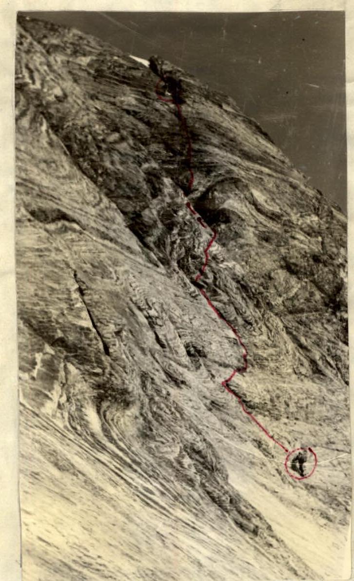
PHOTO 1. The third day of ascent. Climbing the left side of the couloir.
