Introduction
In the center of the Pamir Mountains, in an area that remained a "blank spot" for a long time, between two seven-thousander peaks — Peak Kommunizma (7495 m) and Peak Evgeniya Korzhenevskoi (7105 m) — stands a nameless peak marked on the map as "5691". The summit ridge stretches from east to west and divides the Moskvina Glacier into two branches; to the north and south, the ridge drops off with ice falls and sheer walls. The highest point of the peak is located in the eastern part of the ridge.
This area was not mapped until the early 1930s, and even after that, it was rarely visited — the approaches to the upper reaches of the Moskvina Glacier were too difficult. N.V. Krylenko with two companions was the first to circumnavigate the peak in 1933. His note lay in a large cairn at the lower point of the East Ridge for 33 years! Later, despite the inaccessibility, the area around Peak E. Korzhenevskoi was visited several times by various groups and even entire expeditions, but no attempt was made to climb the nameless peak "5691", which is an excellent panoramic point in the area.
In July-August 1966, an expedition from the Central Sports and Tourism Council of the "Burevestnik" sports organization worked in the upper reaches of the Moskvina Glacier, with the goal of making several ascents of Peak E. Korzhenevskoi via new routes. During the high-altitude acclimatization, one of the expedition groups made the first ascent of the nameless peak "5691" on August 1, 1966, dedicating the climb to the 20th anniversary of the Moscow Institute of Physics and Technology.
Description of the Route via the East Ridge
From the expedition's Base Camp, located in the "pocket" of the left (orogr.) moraine of the Moskvina Glacier (3900 m), we first go up the moraine pocket to the fork of the Moskvina Glacier. Here, we descend from the moraine onto the glacier, cross the left (orogr.) branch — the Walter Glacier — and reach the western slope of peak "5691". Then we proceed along the left (orogr.) moraine of the Moskvina Glacier under the northern slopes of the peak. Attention!
- The slopes of the peak are prone to rockfall and ice avalanches.
- The moraine gradually ends, and the path goes along the edge of the glacier, bypassing a "step" in the ice fall.
- There are hidden crevasses.
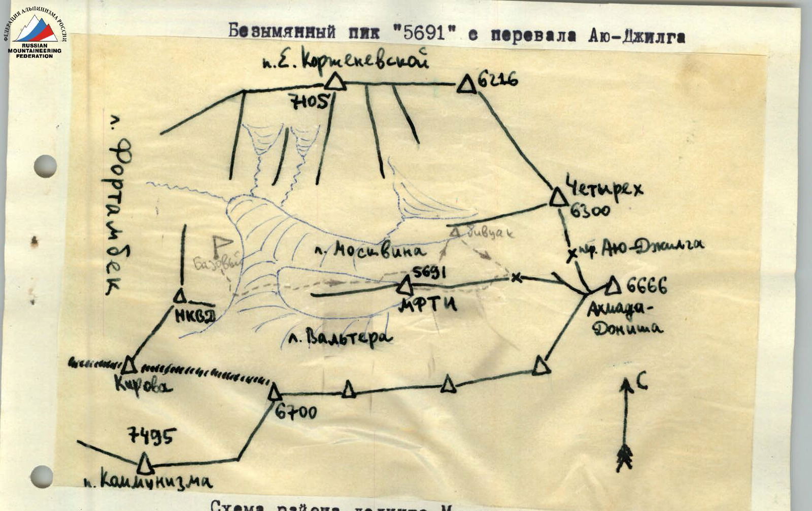
Map of the Moskvina Glacier area — traces of ice avalanches from the slopes of peak "5691".
Above the ice fall, the Moskvina Glacier forms a cirque — a gently sloping, even snowfield — enclosed between:
- the slopes of Peak Chetyrekh,
- the Ayu-Dzhilga pass,
- Peak Akhmada Donisha,
- the East Ridge of peak "5691".
We cross the glacier and set up a bivouac (4900 m) on the moraine under the slopes of Peak Chetyrekh. The journey from the Base Camp takes 5-6 hours.
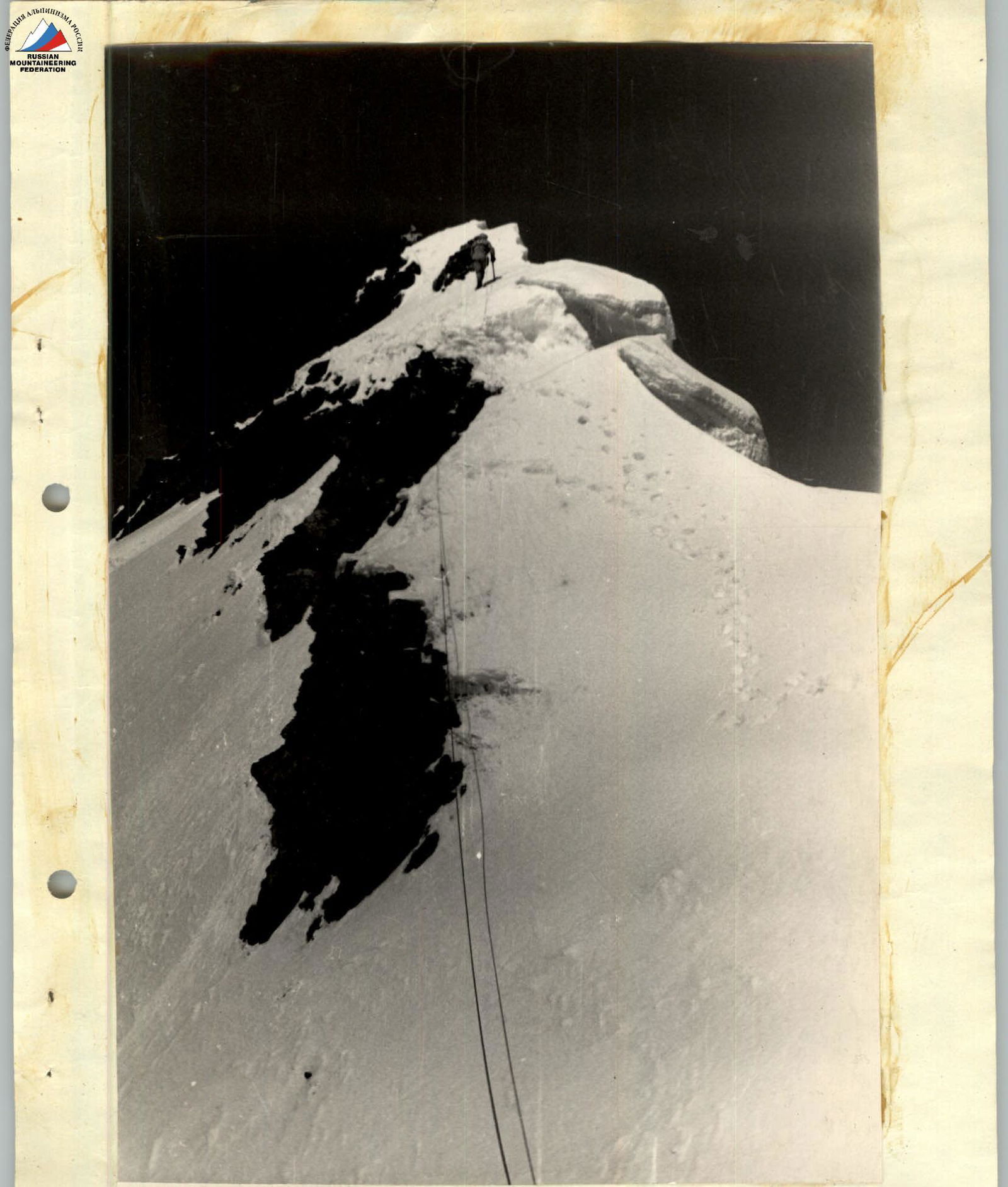
Early in the morning, before the snow on the East Ridge has a chance to soften, we leave the bivouac. We cross the cirque of the Moskvina Glacier in the direction of the lower point of the East Ridge, which is the pass between the cirques of the Walter and Moskvina Glaciers. Attention! There are hidden crevasses along the way. A steep (up to 50°) slope with a bergschrund leads to the ridge, which is easily bypassed. Above is a snowy ridge that drops off towards the Moskvina Glacier with enormous cornices. The path along it does not present serious technical difficulties, but when bypassing the cornices, it is sometimes necessary to walk along the steep (up to 45-50°) southern slopes of the ridge. Belaying is required!
In the middle section, the East Ridge loses its clearly defined character: steep ascents alternate with descents, and the path is blocked by ice falls, over which the ridge turns slightly to the north. It is necessary to go under the ice falls along the northern slope of the ridge and then climb steeply to the ridge, cutting a "window" in a small cornice. Ice-covered rocks are found only near the very summit.
Belaying is required!
The highest point of the peak is a snowy cornice, so we set up a control cairn on the near-summit rocks.
The journey from the bivouac to the summit takes 3.5-4 hours.
The descent via the ascent route takes 1-1.5 hours.
Conclusion
Group composition:
- S. I. Skurlatov — 1st sports category — leader
- Yu. V. Borodkin — 1st sports category — member
- V. P. Egorov — Honorary Master of Sports — member
- S. B. Tikhvinsky — 1st sports category — member
- V. M. Maksimov — 1st sports category — member
- A. P. Shindyakin — 3rd sports category — member
The route via the East Ridge, according to the participants of the first ascent, corresponds to category 3B. Later, the ascent was repeated by a group of trainers. The category of difficulty was confirmed by the Coaching Council of the expedition.
The summit of peak "5691"
Request
The group requests that the Alpine Federation of the USSR name the nameless peak "5691", on which the first ascent was made, Peak "MPhTI" in honor of the 20th anniversary of the Moscow Institute of Physics and Technology. The request is supported by the leadership of the "Burevestnik" expedition.
Leader of the group that made the first ascent — Yu. I. Skurlatov


